
Scattered thunderstorms with severe gusts, hail and a tornado risk are possible near a cold front from the Ohio Valley to the Mid-Atlantic tonight. Tropical Storm Bertha is expected to bring tropical storm conditions to portions of the Gulf Coast from the panhandle of Florida into Louisiana through Wednesday. Read More >
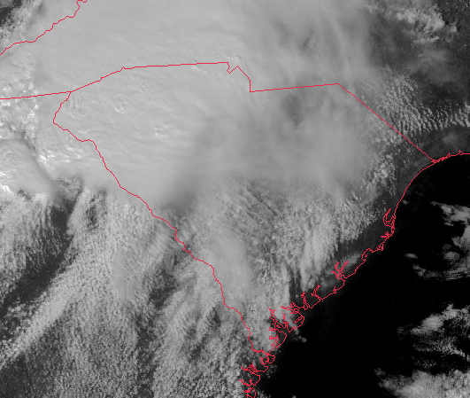
This is a visible satellite loop of the severe storms that moved across the Midlands Saturday afternoon. The time of this loop runs from 2:45 pm until 7:02 pm. Notice the cloud streets moving from southwest to northeast ahead of the cluster of storms, which is indicative of strong inflow to the storms. The letters represent supercell thunderstorms which spawned tornadoes. Hail up to the size of golfballs were reported with many of the storms.
A - This storm produced EF-3 damage in Prosperity and funnel cloud reports in northern Richland County.
B - This storm produced EF-0 to EF-1 damage across McCormick and northern Edgefield Counties, EF-0 damage near Pelion and St. Matthews.
C - This storm produced EF-0 damage in northern Columbia County, GA and EF-2 damage in Clearwater. The most significant damage along its track was rated EF-3 in Branchville.
D - This storm produced EF-2 damage in Elgin and EF-1 damage in Lee County south of Bishopville.
E - This storm produced EF-1 damage near Keysville, GA.
F - This storm produced EF-1 damage east of Waynesboro, GA.

