A strong and potent storm in the Upper Great Lakes drove a cold front through Lower Michigan during the evening and overnight hours on October 18 and 19. Ahead of the cold front the atmosphere was very warm, moist and unstable. These conditions combined with the strong storm to produce a widespread tornado and severe weather outbreak across the Great Lakes, Ohio Valley, and Tennessee Valley. Tornadoes were reported across Northern Lower Michigan, Southwest Lower Michigan, Southeast Lower Michigan as well as Northern Indiana.
Eleven tornadoes have been confirmed in Michigan’s Lower Peninsula during this outbreak. Unfortunately, three people were killed in the state, two near Williamston and one near Kalkaska. Five tornadoes have been confirmed in Southeast Michigan in Shiawassee, Genesee, Tuscola and Huron Counties. Below is a listing of tornado outbreaks, since 1950, across the state:
| Southeast Michigan Data | State of Michigan Data | |||||||||||||||
| Date | F0 | F1 | F2 | F3 | F4 | F5 | Total | F0 | F1 | F2 | F3 | F4 | F5 | Total | ||
| 6/8/53 | 1 | 2 | 2 | 1 | 6 | 1 | 1 | 3 | 2 | 1 | 8 | |||||
| 5/12/56 | 1 | 1 | 2 | 2 | 6 | 1 | 1 | 6 | 2 | 10 | ||||||
| 4/11/65 | 2 | 3 | 5 | 1 | 4 | 2 | 5 | 12 | ||||||||
| 4/21/67 | 0 | 1 | 1 | 6 | 1 | 1 | 10 | |||||||||
| 6/26/73 | 6 | 3 | 9 | 6 | 3 | 9 | ||||||||||
| 7/14/74 | 4 | 1 | 1 | 6 | 6 | 1 | 1 | 8 | ||||||||
| 6/15/82 | 2 | 3 | 1 | 6 | 3 | 4 | 1 | 8 | ||||||||
| 9/14/90 | 1 | 2 | 1 | 4 | 1 | 5 | 1 | 7 | ||||||||
| 3/27/91 | 2 | 1 | 3 | 5 | 3 | 3 | 4 | 15 | ||||||||
| 7/2/97 | 1 | 9 | 1 | 2 | 13 | 2 | 9 | 3 | 2 | 16 | ||||||
| 5/21/01 | 3 | 1 | 4 | 13 | 4 | 2 | 19 | |||||||||
| 10/24/01 | 1 | 2 | 3 | 3 | 7 | 9 | ||||||||||
| 8/24/07* | 2 | 1 | 1 | 4 | 2 | 2 | 1 | 1 | 6 | |||||||
| 10/18-19/07* | 1 | 4 | 5 | 1 | 5 | 5 | 11 | |||||||||
*Tornadoes rated on the Enhanced Fujita Scale (EF) after February 1, 2007
While October tornado events in Southeast Michigan are rare, October 18 and 19, 2007 is reminiscent of October 24, 2001. On that date, 9 tornadoes developed across Michigan including three in Southeast Michigan. Looking specifically at Southeast Michigan tornado statistics, we find that 7 October tornadoes have occurred between 1950 and 2006, including those 3 back in 2001.
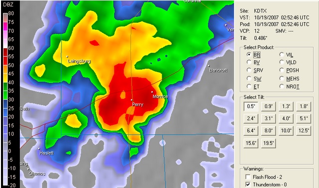
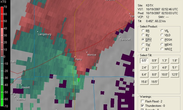
The tornado in Shiawassee County was a continuation of the Williamston/Ingham County Tornado. The tornado moved from Ingham County into Shiawassee County for about 2 miles, just south of Perry. In Shiawassee County, the tornado damage was rated as an EF1 on the Enhanced Fujita Scale with winds estimated up to 100 mph. Damage in Shiawassee County occurred around 10:53 p.m. and included 4 barns and 3 houses. One house had windows blown out, one farm house had a section of roof taken off, and the third modular home had the entire roof taken off. The damage path in Shiawassee County was about 100 yards wide.
The tornado in Genesee County occurred around 1:06 a.m. in Thetford Township about 5 miles east of Clio. The tornado was rated as an EF0 with winds estimated around 80 mph. The tornado damage was 2 1/2 miles long and 50 yards wide. It started near Center and Vienna Roads and ended in Buell Lake Park. Most of the damage was to large trees with many snapped or uprooted. One home had shingle damage and a barn had a portion of its metal roof peeled off.
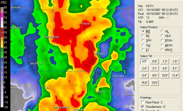
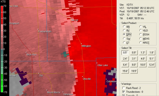
The Millington tornado in Tuscola County occurred around 1:16 a.m. This tornado was rated a strong EF1 with winds estimated around 105 mph. The tornado damage was 2 miles long and 30 yards wide. The tornado started just west of Barnes and Fulmer Roads just southwest of town, where a modular home was completely destroyed and a framed house lost a section of its roof. The tornado ended north of Main Street and Caine Road in Millington.
At around 1:45 a.m. two miles west of Deford in Tuscola County, a tornado rated as EF1
with estimated winds around 95 mph caused substantial damage. Its damage path was around
100 yards wide and about 3 miles long. A garage was destroyed, several houses
sustained roof damage, and numerous trees were snapped off or uprooted.
At around 2:30 a.m. four miles west of Port Hope in Huron County, a tornado rated as EF1
with estimated winds around 100 mph caused substantial damage. Its damage path was around
100 yards wide and about a mile long. Large heavy farm machinery was lifted and displaced,
and a farm shed was moved about 120 feet off of its foundation. Also, the walls of a large
barn were lifted 6 to 8 feet from their foundation.
Below are the Base Reflectivity and Storm Relatively Velocity (SRM) images from near Perry and Millington
The updated preliminary storm reports from yesterday’s severe weather in Southeast Michigan are listed below.
000
NWUS53 KDTX 200144
LSRDTX
PRELIMINARY LOCAL STORM REPORT...SUMMARY
NATIONAL WEATHER SERVICE DETROIT/PONTIAC MI
945 PM EDT FRI OCT 19 2007
..TIME... ...EVENT... ...CITY LOCATION... ...LAT.LON...
..DATE... ....MAG.... ..COUNTY LOCATION..ST.. ...SOURCE....
..REMARKS..
0842 PM TSTM WND DMG 2 W BRANT 43.26N 84.27W
10/18/2007 SAGINAW MI LAW ENFORCEMENT
CENTRAL DISPATCH RECEIVED A REPORT OF A VERY LARGE TREE
DOWN ON THE 18000 BLOCK OF BRANT ROAD.
0848 PM TSTM WND DMG 3 W ST. CHARLES 43.30N 84.21W
10/18/2007 SAGINAW MI LAW ENFORCEMENT
CENTRAL DISPATCH RECEIVED A REPORT OF A TREE DOWN ON
RAUCHOLZ RD.
1005 PM HAIL COLEMAN 43.76N 84.59W
10/18/2007 E1.00 INCH MIDLAND MI AMATEUR RADIO
1053 PM TORNADO 2 SSE PERRY 42.79N 84.21W
10/18/2007 SHIAWASSEE MI NWS STORM SURVEY
DAMAGE SURVEY RATED THE TORNADO AS EF1 WITH ESTIMATED
WINDS OF 100MPH. THE PATH LENGTH WAS ESTIMATED AT 2 MILES
LONG WITH A WIDTH OF 100 YARDS WIDE. STRUCTURAL DAMAGE
OCCURED ON 4 BARNS AND THREE HOUSES.
1132 PM TSTM WND DMG 4 N FLUSHING 43.12N 83.84W
10/18/2007 GENESEE MI LAW ENFORCEMENT
LARGE TREE LIMBS DOWN...MOUNT MORRIS AND SEYMOUR ROAD.
1247 AM TSTM WND GST 5 W SWARTZ CREEK 42.96N 83.93W
10/19/2007 E65.00 MPH SHIAWASSEE MI AMATEUR RADIO
A TRAINED SPOTTER ESTIMATED WIND GUSTS AT 60 TO 65 MPH.
0101 AM HAIL 1 W CLIO 43.18N 83.76W
10/19/2007 E0.75 INCH GENESEE MI AMATEUR RADIO
0106 AM TORNADO 5 E CLIO 43.18N 83.64W
10/19/2007 GENESEE MI NWS STORM SURVEY
DAMAGED SURVEY RATED AS EF0 WITH ESTIMATED WINDS OF UP TO
80MPH. THE PATH OF THE TORNADO WAS DETERMINED TO BE 2 1/2
MILES LONG WITH A WIDTH OF 50 YARDS. DAMAGE INCLUDED
SNAPPED/UPROOTED TREES...ROOF DAMAGE ON MULTIPLE
STRUCTURES.
0116 AM TORNADO 1 SSW MILLINGTON 43.27N 83.54W
10/19/2007 TUSCOLA MI NWS STORM SURVEY
DAMAGE SURVEY RATED TORNADO AS A STRONG EF1 WITH
ESTIMATED WINDS OF 105 MPH. THE PATH LENGTH IS ESTIMATED
AT 2 MILES LONG WITH A WIDTH OF 30 YARDS. THE DAMAGE
INCLUDED THE DEMOLITION OF 2 HOUSES AT BARNES AND FULMER
ROADS.
0133 AM TSTM WND DMG 6 W NORTH BRANCH 43.23N 83.31W
10/19/2007 LAPEER MI EMERGENCY MNGR
MULTIPLE TREES DOWN
0145 AM TORNADO 2 W DEFORD 43.51N 83.23W
10/19/2007 TUSCOLA MI LAW ENFORCEMENT
DAMAGE SURVEY RATED TORNADO AS EF1 WITH ESIMATED WINDS
AROUND 95 MPH CAUSED SUBSTANTIAL DAMAGE. ITS DAMAGE PATH
WAS AROUND A HALF MILE WIDE AND ABOUT 3 MILES LONG. A
TRAILER BLOWN INTO NEARBY POND...A GARAGE WAS DESTROYED
... SEVERAL HOUSES SUSTAINED ROOF DAMAGE...AND NUMEROUS
TREES WERE EITHER SNAPPED OFF...UPROOTED OR DOWNED.
0230 AM TORNADO 4 W PORT HOPE 43.93N 82.75W
10/19/2007 HURON MI NWS STORM SURVEY
DAMAGE SURVEY RATED TORNADO AS EF1 WITH ESTIMATED WINDS
AROUND 100 MPH CAUSED SUBSTANTIAL DAMAGE. ITS DAMAGE PATH
WAS AROUND 300 FEET WIDE AND ABOUT A MILE LONG. LARGE HEAVY
FARM MACHINERY WAS LIFTED AND DISPLACED...A FARM SHED WAS
MOVED ABOUT 120 FEET OFF ITS FOUNDATION. ALSO THE WALLS
OF A LARGE BARN WERE LIFTED 6 TO 8 FEET FROM THEIR FOUNDATION.
&&
UPDATED TO INCLUDE STORM SURVEY INFORMATION AND ADDITIONAL REPORTS.
$$

