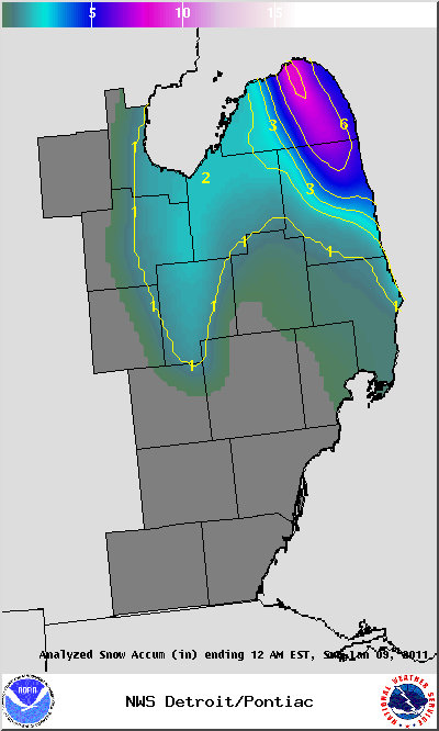
Several rounds of Lake Effect Snow brought several inches of snow to the northern and eastern thumb on Saturday January 8, 2011. The highest snowfall totals were across Huron County where up to 8 inches of snow fell near Port Austin as well as Sanilac County with 6 inches of snow at Minden. A graphic showing the reported snowfall totals and summary statement with reported snowfall amounts are below.
Snowfall Totals:
PUBLIC INFORMATION STATEMENT...STORM TOTALS
NATIONAL WEATHER SERVICE DETROIT/PONTIAC MI
1127 AM EST SUN JAN 9 2011


STORM TOTAL SNOW REPORTS

LOCATION                  SNOWFALL     DURATION
                          (INCHES)      (HOURS)        LAT       LON

...GENESEE COUNTY...
   4 S FLINT               M   1.5            1     42.96N    83.69W
   7 W FLINT               M   1.8            1     43.02N    83.83W
   SWARTZ CREEK            M   1.8            1     42.96N    83.83W

...HURON COUNTY...
   1 ENE PORT AUSTIN       M   4.0            7     44.05N    82.97W
   1 SSE HARBOR BEACH      M   4.0            8     43.83N    82.65W
   5 NNW FILION            M   4.0            7     43.96N    83.04W
   PORT AUSTIN             M   4.0            6     44.04N    83.00W
   BAD AXE                 M   5.0            7     43.80N    83.00W
   1 WNW BAD AXE           M   5.5            6     43.81N    83.02W
   UBLY                    E   7.0            7     43.71N    82.93W
   2 WSW PORT AUSTIN       M   8.0           10     44.03N    83.03W

...SANILAC COUNTY...
   LEXINGTON               M   1.5            3     43.27N    82.53W
   SANDUSKY                E   3.0            3     43.42N    82.83W
   MINDEN                  E   6.0            6     43.67N    82.78W

...ST. CLAIR COUNTY...
   JEDDO                   E   1.0            3     43.15N    82.58W


M = MEASURED
E = ESTIMATED

