A low pressure system moved across southern Michigan overnight producing a wide range of precipitation types and amounts. 5-8 inches of snow fell across locations north of the I-69 corridor mixing with freezing rain during the morning hours for a while. Though ice stuggled to form on most roadways, 0.1-0.3 of ice, was able to accumulate on trees and powerlines along I-69 causing about ten thousand of people to lose power in Shiawassee, Genesee, Lapeer, St. Clair, Macomb, and Oakland Counties. The ice was in addition to 1-3 inches of snow and sleet that had fallen earlier in the night. South of I-69, the precipitation changed rapidly from a sleet/freezing rain mix along the M-59 corridor to all rain from about I-696 southward. 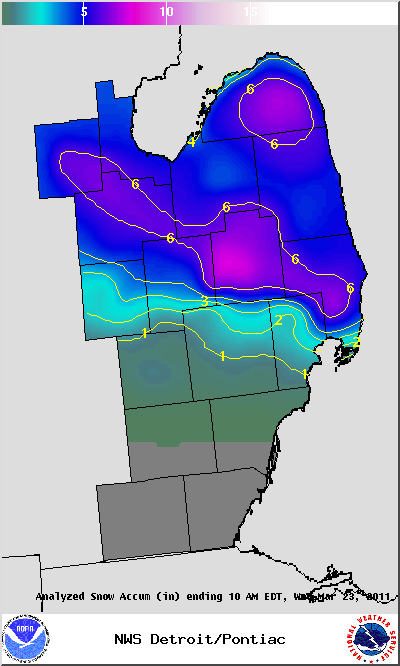
STORM TOTAL FREEZING RAIN REPORTS

LOCATION                   PRECIP      DURATION
                          (INCHES)      (HOURS)        LAT       LON

...OAKLAND COUNTY...
   HIGHLAND                E  0.10            M     42.64N    83.62W

...ST. CLAIR COUNTY...
   ALGONAC                 M  0.25            M     42.62N    82.53W

STORM TOTAL SNOW REPORTS

LOCATION                  SNOWFALL     DURATION
                          (INCHES)      (HOURS)        LAT       LON

...LAPEER COUNTY...
   ELBA                    M   6.5           12     43.04N    83.44W

...MIDLAND COUNTY...
   6 N MIDLAND             M   6.2           14     43.71N    84.23W
   MIDLAND                 M   8.0           14     43.62N    84.23W

...SAGINAW COUNTY...
   3 NW SAGINAW            M   5.8           14     43.45N    83.99W

...ST. CLAIR COUNTY...
   CAPAC                   M   6.5           14     43.01N    82.93W

...BAY COUNTY...
   AUBURN                  M   5.8           14     43.60N    84.08W

...GENESEE COUNTY...
   LINDEN                  M   0.3            M     42.82N    83.78W
   GOODRICH                M   2.8           14     42.92N    83.51W
   DAVISON                 M   3.5           12     43.03N    83.52W
   BURTON                  M   5.2           14     43.00N    83.62W

...HURON COUNTY...
   PORT AUSTIN             M   4.0           14     44.04N    83.00W
   HARBOR BEACH            M   4.5           14     43.85N    82.65W
   5 NNW FILION            M   5.1           13     43.96N    83.04W
   PORT HOPE               M   6.8           14     43.94N    82.72W
   BAD AXE                 M   7.0           14     43.80N    83.00W

...LAPEER COUNTY...
   LAPEER                  M   7.9           14     43.05N    83.32W

...MACOMB COUNTY...
   SSE NEW BALTIMORE       M   1.7           14     42.68N    82.74W
   SHELBY TOWNSHIP         M   1.9           14     42.67N    83.03W
   RICHMOND                M   6.6           14     42.81N    82.75W

...MIDLAND COUNTY...
   MIDLAND                 M   4.7           14     43.62N    84.23W

...OAKLAND COUNTY...
   PONTIAC                 M   0.6            M     42.65N    83.29W

...SAGINAW COUNTY...
   MERRILL                 M   3.0            M     43.41N    84.34W
   CHESANING               M   3.6           14     43.18N    84.12W
   FREELAND                M   4.5           14     43.52N    84.12W

...SANILAC COUNTY...
   LEXINGTON               M   5.0           14     43.27N    82.53W
   SANDUSKY                M   5.0           14     43.42N    82.83W
   MARLETTE                M   6.5           15     43.33N    83.08W

...SHIAWASSEE COUNTY...
   DURAND                  E   1.5           14     42.91N    83.99W
   OWOSSO                  M   2.0           14     43.00N    84.18W
   CORUNNA                 M   3.0           13     42.98N    84.12W

...ST. CLAIR COUNTY...
   ALGONAC                 M   1.4            M     42.62N    82.53W
   ST. CLAIR               M   4.6           14     42.82N    82.49W
   PORT HURON              M   4.7           14     42.99N    82.43W
   ALLENTON                M   5.0           14     42.92N    82.95W
   YALE                    M   5.0           14     43.13N    82.80W
   YALE                    M   5.0           14     43.13N    82.80W
   PORT HURON              M   5.1           14     42.99N    82.43W
   PORT HURON              M   5.2           14     42.99N    82.43W

...TUSCOLA COUNTY...
   CARO                    E   4.0           14     43.49N    83.40W
   VASSAR                  M   5.2           14     43.37N    83.58W


M = MEASURED
E = ESTIMATED

$$

