An amplified, upper level weather pattern allowed for an unseasonably warm and humid air mass to infiltrate the southern Great Lakes region in March. Highly anomalous for the month of March, surface dew points climbed into the lower 60 degree range across much of Southeastern Michigan. This rich moisture combined with an upper level disturbance tracking northward through Lower Michigan on both March 12 and March 15. These conditions fueled the severe thunderstorms in Midland and Bay Counties on March 12 and then the long duration severe thunderstorm event across Southeastern Michigan on March 15. The primary severe weather type observed with these storms was very large hail, along with a few tornadoes.
Severe Weather Reports 3/12/2012

March tornadoes in Southeast Michigan are rare. Prior to the Coleman tornado on March 12, just 9 tornadoes had been recorded before April 1 in Southeast Michigan (the 17 counties that represent the NWS Detroit/Pontiac area of responsibility). Tornado statistics go back to 1950. In 2012, there were 4 tornadoes in Southeast Michigan.
The Coleman and Columbiaville tornadoes were the first to occur north of Interstate 69 in the month of March. The March 12 date also marks a tie for the second earliest tornado in Southeast Michigan and the March 15 date marks the fourth earliest tornado in Southeast Michigan since 1950.
Here is a list of the February and March tornadoes...
| County | Date |
EF or F Scale Rating |
| Monroe | 03/26/1968 | 2 |
| Wayne | 02/28/1974 | 2 |
| Lenawee | 03/12/1976 | 2 |
| Oakland | 03/20/1976 | 4 |
| Macomb | 03/20/1976 | 3 |
| Monroe | 03/27/1991 | 0 |
| Monroe | 03/27/1991 | 0 |
| St. Clair | 03/27/1991 | 1 |
| Lenawee | 03/28/1998 | 1 |
| Midland | 03/12/2012 | 1 |
| Washtenaw | 03/15/2012 | 3 |
| Monroe | 03/15/2012 | 0 |
| Lapeer | 03/15/2012 | 2 |
Dexter Tornado
A National Weather Service Storm Survey confirmed an EF-3 tornado touched down near Dexter, MI with maximum wind speeds of 135-140 mph. The path length was 7.6 miles with an average width of 400 yards and a maximum width of 800 yards. The tornado touched down at 5:18pm just northeast of the intersection of N Territorial and Dexter Townhall Rd. The tornado moved southeast and produced EF-1 damage with winds estimated at 100 mph. Damage was limited to uprooted and snapped trees as well as minor roof damage. The tornado strengthened as it hit the Horseshoe Bend Subdivision with winds estimated at 120 mph and structural damage to the outside of homes. The tornado then continued to track southeast alongside Dexter-Pinckney Rd. and produced EF-3 damage at 5:31pm. Winds estimated at 135-140 mph destroyed one home northwest of Dexter. The tornado was nearly stationary and wobbled around for nearly 5 minutes just northwest of the village of Dexter before turning left, paralleling the Huron River and the producing EF-2 damage on the north side of Dexter. The tornado then produced EF-3 damage again at 5:49pm in the Huron Farms Subdivision with winds estimated at 135-140 mph. One home was destroyed and another house had only interior rooms left standing. The tornado then weakened as it moved southeast and lifted at 5:56pm near the intersection of Zeeb Rd. and Ann Arbor-Dexter Rd.
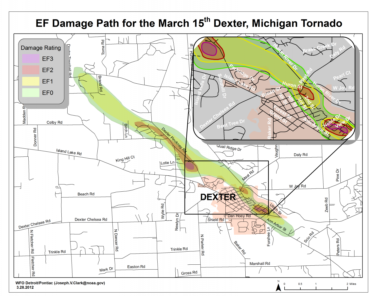
Path of the 3/15/2012 tornado that occurred near Dexter, MI in Washtenaw County
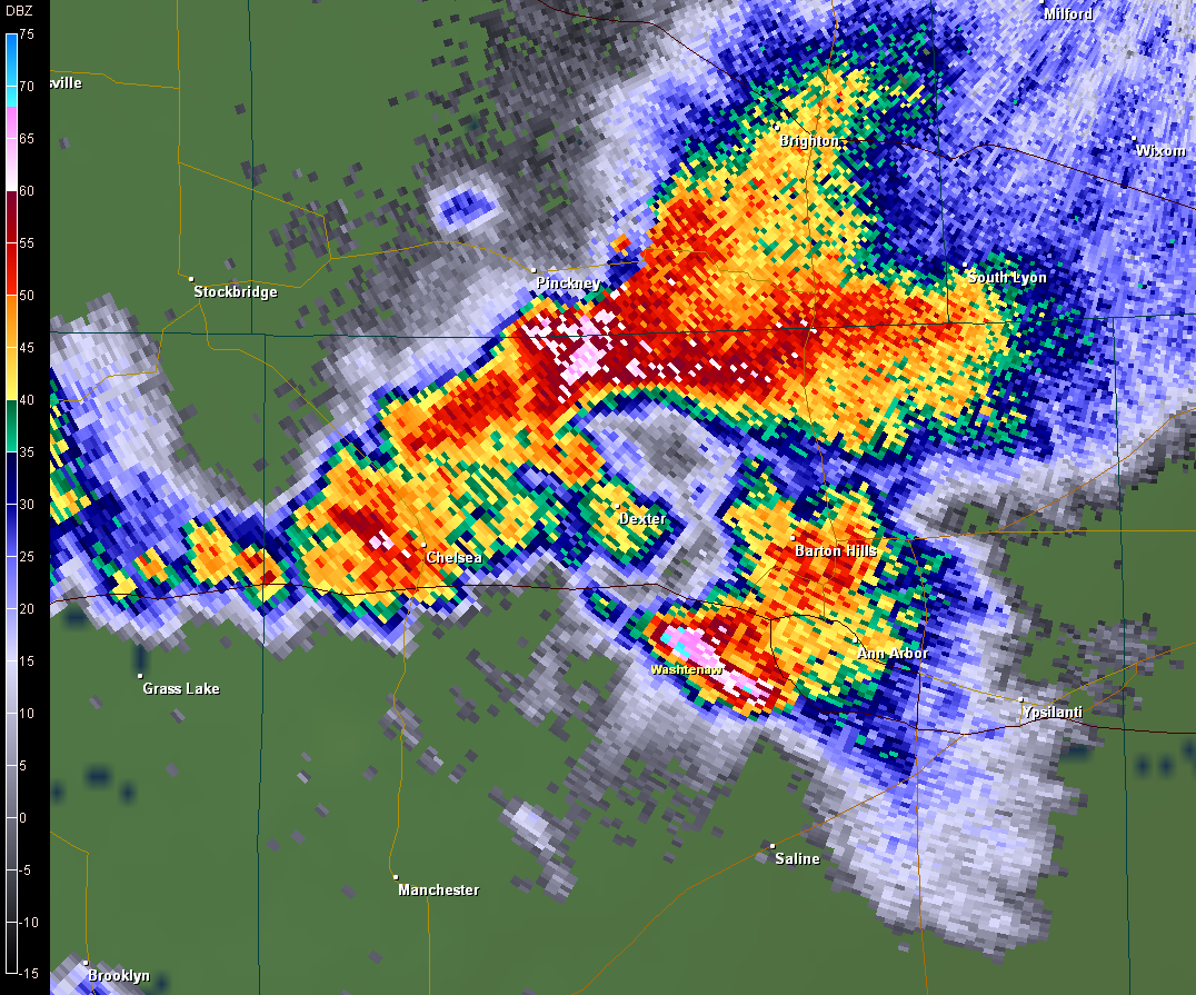
KDTX .5 degree base reflectivity 5:31 PM EDT centered over Dexter storm
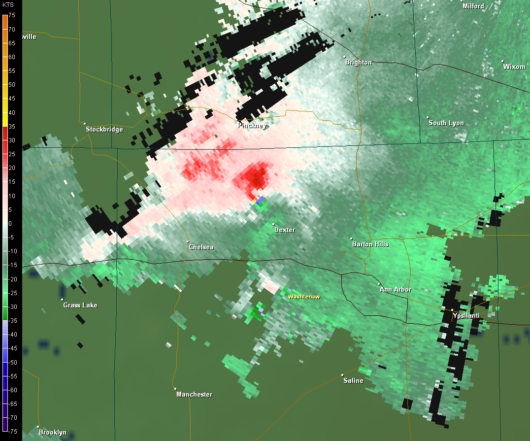
KDTX .5 storm relative motion 5:31 PM EDT centered over Dexter storm
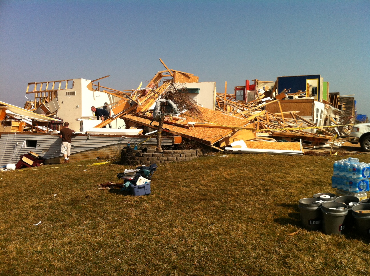
Damage southeast of Dexter in the Huron Farms
subdivison.
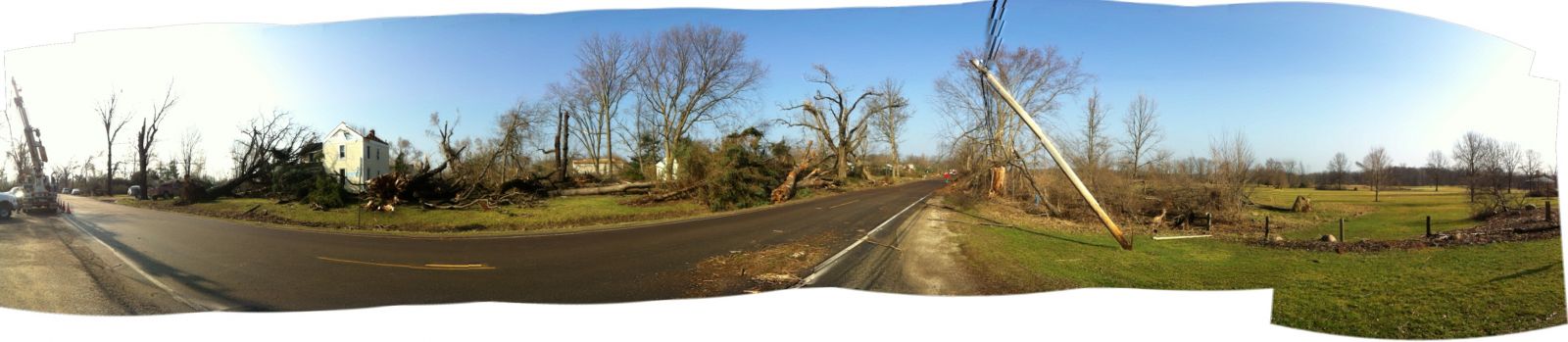
Panorama view of Dexter-Pinckney Road, northwest of the village of Dexter.
Ida Tornado
A tornado was confirmed in central Monroe county. The tornado was rated an EF0, with maximum wind speeds of 85 mph. The estimated path length of the tornado is 0.5 miles with a maximum width of 50 yards. Damage occurred along Ida Center Road just east of Lewis Rd. The damage consisted of siding and shingles blown off a house, a tipped car, a shed destroyed and trees blown down.
Columbiaville (Lapeer Co.) Tornado
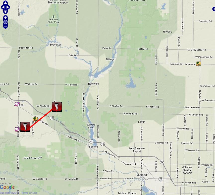
A National Weather Service Storm Damage Survey confirmed the occurrence of a tornado in western Lapeer County, approximately 3 miles south of Columbiaville or 5 miles northwest of Lapeer. The tornado produced damage consistent with a rating of EF2, with maximum wind speeds of around 125 mph. The tornado damage path was roughly 4.5 miles long with a maximum width of 400 yards. The damage extends from near the intersection of Mt. Morris Road and German Road with a touchdown of approximately 649 PM EDT to near the intersection of Flint River Road and Millville Road by approximately 704 PM EDT. Damage along much of the path was primarily uprooted trees and minor structural damage. The most intense damage occurred along Carpentar Road, roughly one quarter mile south of Stanley Road, at 700 PM EDT. A house was shifted off the foundation and an attached garage was destroyed at this location.
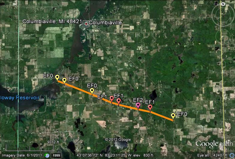
Path of the 3/15/2012 tornado that occurred near Columbiaville, MI in Lapeer County
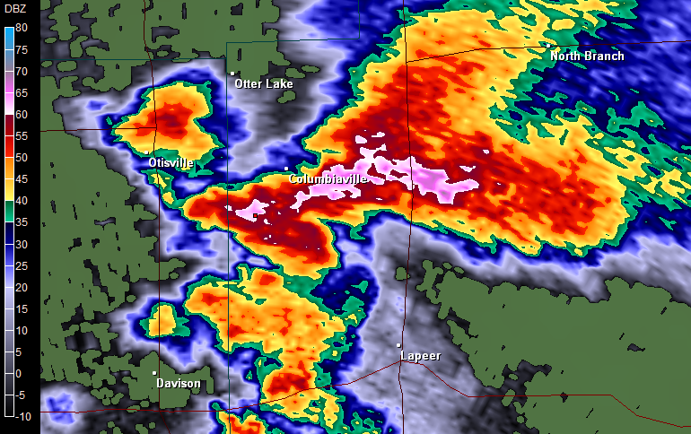
KDTX .5 degree base reflectivity 6:53 PM EDT centered over Lapeer County storm
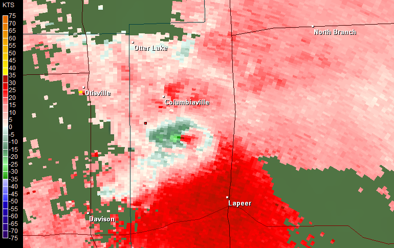
KDTX .5 storm relative motion 6:57 PM EDT centered over Lapeer County storm

