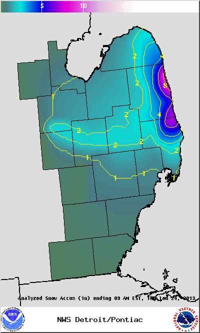
Lake effect snow developed over Lake Huron early on January 24th, bringing up to 8 inches of heavy snow to the eastern Thumb region during the morning hours. Further inland snowfall amounts were lighter but still amounted to1 to 3 inches along the Interstate 69 corridor. Below is a map of the snow totals reported to the NWS in White Lake:
Below are the raw snowfall totals reported to the NWS from our observers:
PUBLIC INFORMATION STATEMENT...STORM TOTALS
NATIONAL WEATHER SERVICE DETROIT/PONTIAC MI
121 PM EST THU JAN 24 2013


STORM TOTAL SNOW REPORTS

LOCATION                  SNOWFALL     DURATION
                          (INCHES)      (HOURS)        LAT       LON

...HURON COUNTY...
   BAD AXE                 M   1.8           24     43.80N    83.00W
   PORT AUSTIN             M   2.0           24     44.04N    83.00W
   HARBOR BEACH            E   3.0            6     43.85N    82.65W

...LAPEER COUNTY...
   LAPEER                  M   2.0           24     43.05N    83.32W

...SAGINAW COUNTY...
   CHESANING               M   3.3           24     43.18N    84.12W

...SANILAC COUNTY...
   SANDUSKY                M   2.0           24     43.42N    82.83W
   LEXINGTON               M   3.6           12     43.27N    82.53W
   CARSONVILLE             M   4.0            6     43.43N    82.67W
   FORESTER                E   7.0            6     43.50N    82.57W
   1 N PORT SANILAC        E   8.0            6     43.45N    82.55W
   2 S FORESTVILLE         E   8.0            6     43.64N    82.61W
   5 ENE CROSWELL          E   8.0            6     43.31N    82.53W
   5 S LEXINGTON           E   8.0            6     43.20N    82.53W

...ST. CLAIR COUNTY...
   ALGONAC                 M   1.5            6     42.62N    82.53W
   PORT HURON              M   2.4            4     42.99N    82.43W
   YALE                    M   3.2           24     43.13N    82.80W
   5 SSE LAKEPORT          E   4.0            6     43.06N    82.46W
   GOODELLS                M   4.5           12     42.98N    82.68W
   LAKEPORT                E   6.0            6     43.12N    82.50W
   2 N SMITHS CREEK        E   8.0            6     42.95N    82.60W


M = MEASURED
E = ESTIMATED

