Overview
Snowfall Records
Detroit:
Record Daily Maximum Snowfall of 8.5 inches was set at Detorit Metro Airport on November 11th, which breaks the old record of 4.1 inches back in 1984. The 8.5 inches, also breaks the November daily snowfall with a previous record of 6.2 inches back on November 15, 1925.
This snow storm, with a total measurement of 9.2 inches over November 11-12, 2019, ranks as the biggest November snow storm in Detroit. This breaks the old record of 9.0 inches, set back on November 15-16, 1932.
Flint:
Record Daily Maximum Snowfall of 8.6 inches was set at Flint Bishop Airport on November 11th, which breaks the old record of 3.0 inches back in 1933.
Flint tied for the 3rd biggest November winter storm with 9.0 inches of snow. The biggest November storm for Flint dumped 13.4 inches on November 6-7, 1951.
Event Summary
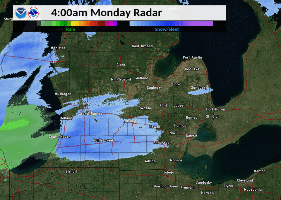
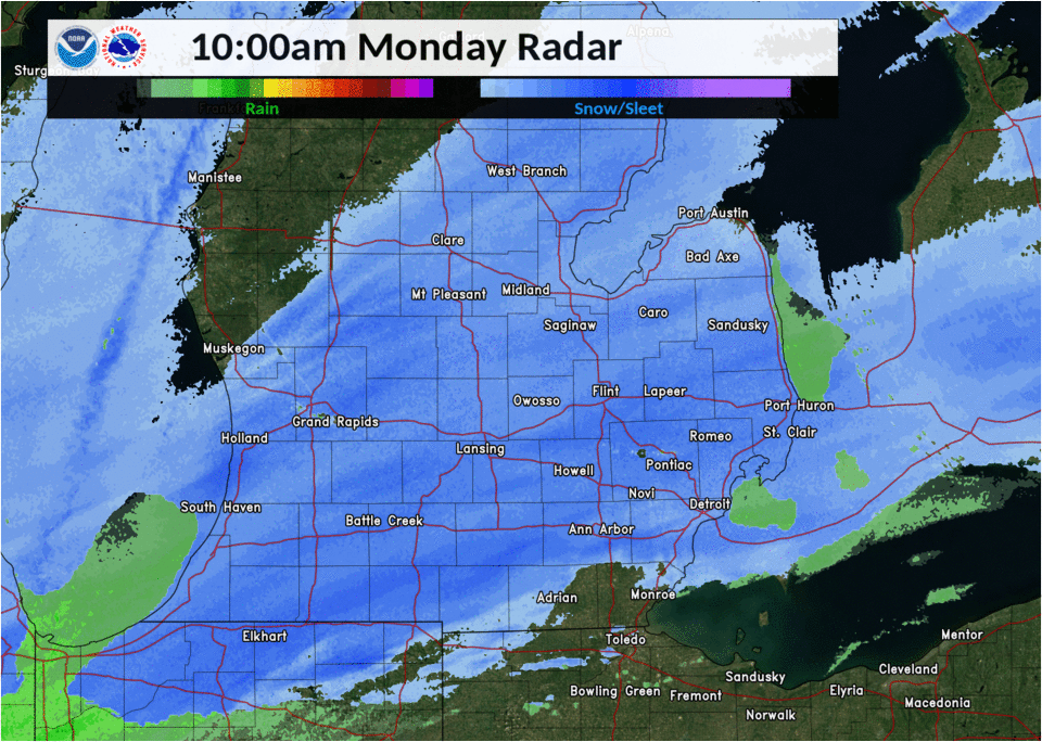
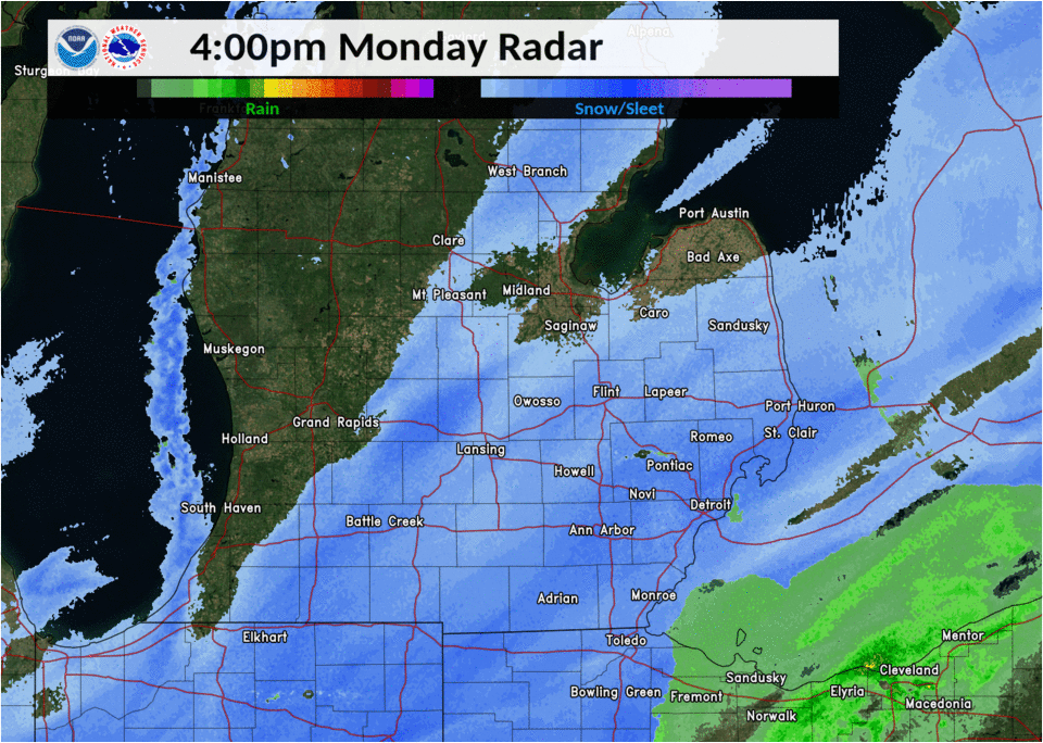
During the early morning period of November 11th, a surface low pressure began to develop over the Ohio Valley tied to a stationary boundary over that region. Snow started to move into SE MI from the west shortly after 3am with the bulk of the region seeing snow falling by 4am. The initial part of the storm had 3 distinct heavier snow bands develop across our region that would begin to collapse together to form one distinct very heavy band by the noon/early afternoon timeframe. This band had 1" per hour snowfall rates over the western and northern Metro areas leading to the high totals seen across Washtenaw, Oakland, and Macomb counties. It would slowly move and pivot east across Detroit and the southern Metro area later in the afternoon as the low began to move east into Pennsylvania. While all this occurred, northerly flow off of Lake Huron allowed for lake-enhanced snowfall rates over the Thumb, especially over areas on the northern and eastern shorelines with some locations seeing over a foot of snow.
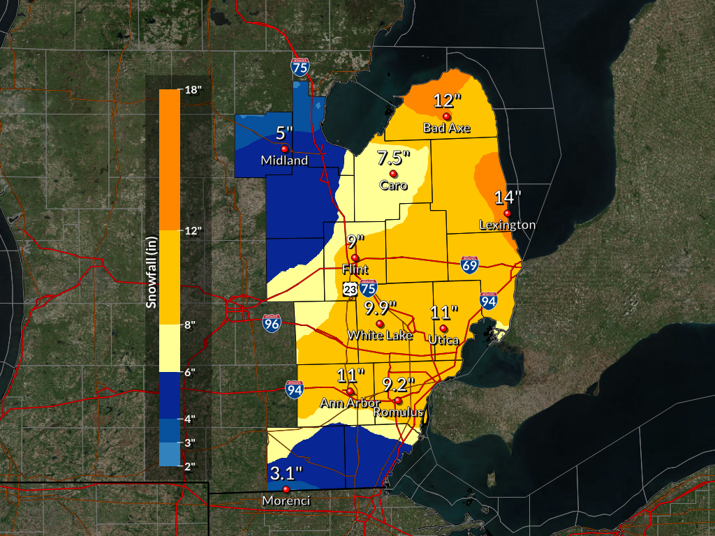
Snowfall Totals
For more detailed snow reports, please see the storm reports tab.
Radar
 |
 |
 |
|
Radar Loop of Snow Event from 4 am to 10 am |
Radar Loop of Snow Event from 10 am to 4 pm |
Radar Loop of Snow Event from 4 pm to 10 pm |
Storm Reports
Public Information Statement...Storm Totals
National Weather Service Detroit/Pontiac MI
1032 AM EST Tue Nov 12 2019


STORM TOTAL SNOW REPORTS

Location                  Snowfall     Duration
                          (Inches)      (Hours)        Lat       Lon

...Bay County...
   Auburn                  M   2.8           24     43.60N    84.08W

...Genesee County...
   Goodrich                M   7.9           30     42.92N    83.51W
   4 N Burton              M   9.3           30     43.05N    83.62W

...Huron County...
   Harbor Beach            M   6.0           30     43.85N    82.65W
   Filion                  M   8.7           30     43.90N    83.00W
   Bad Axe                 M  12.0           30     43.80N    83.00W

...Lapeer County...
   Lapeer                  M   7.5           30     43.05N    83.32W
   Elba                    M   9.5           30     43.04N    83.44W

...Lenawee County...
   Morenci                 M   3.1           30     41.72N    84.22W
   2 WNW Tipton            M   6.3           24     42.03N    84.10W

...Livingston County...
   Pinckney                M   8.2           24     42.45N    83.95W
   1 NE Howell             M   8.4           30     42.62N    83.92W

...Macomb County...
   1 ENE Roseville         M   7.5           24     42.51N    82.92W
   4 NNW Richmond          M   9.5           30     42.86N    82.78W
   2 E Utica               M   9.9           24     42.63N    82.98W
   Sterling Heights        M  10.0           30     42.58N    83.03W
   Shelby Township         M  11.0           30     42.67N    83.03W

...Midland County...
   Oil City                M   4.2           30     43.61N    84.59W
   1 S Midland             M   5.0           30     43.61N    84.23W

...Monroe County...
   Monroe                  M   4.5           24     41.92N    83.39W
   Dundee                  M   5.1           30     41.96N    83.66W

...Oakland County...
   West Bloomfield         M   8.7           30     42.57N    83.38W
   Farmington              M   9.4           30     42.46N    83.38W
   Troy                    M   9.5           30     42.58N    83.14W
   4 E White Lake          M   9.9           30     42.65N    83.43W
   Wixom                   M  10.0           30     42.52N    83.54W
   4 SSE Lake Orion        M  10.6           24     42.73N    83.21W

...Saginaw County...
   2 NW Saginaw            M   4.8           30     43.44N    83.98W
   Chesaning               M   5.0           24     43.18N    84.12W
   Shields                 M   6.0           20     43.42N    84.07W

...Sanilac County...
   Peck                    M   8.3           20     43.26N    82.82W
   Peck                    M  10.0           30     43.26N    82.82W
   Lexington               M  14.0           30     43.27N    82.53W

...Shiawassee County...
   Owosso                  M   5.8           30     43.00N    84.18W

...St. Clair County...
   Yale                    M   7.8           30     43.13N    82.80W
   Port Huron              M  11.0           30     42.99N    82.43W
   Port Huron              M  14.0           30     42.99N    82.43W

...Tuscola County...
   Cass City               M   6.0           24     43.60N    83.18W
   Vassar                  M   6.5           30     43.37N    83.58W
   Caro                    M   7.5           30     43.49N    83.40W

...Washtenaw County...
   Milan                   M   3.0           30     42.09N    83.68W
   Manchester              M   8.5           30     42.15N    84.04W
   Se Ann Arbor            M  10.3           30     42.28N    83.73W
   Ann Arbor               M  11.0           30     42.28N    83.73W

...Wayne County...
   Riverview               M   7.5           30     42.17N    83.19W
   Garden City             M   8.4           30     42.33N    83.33W
   Wyandotte               M   8.8           30     42.21N    83.16W
   Romulus                 M   9.2           30     42.22N    83.37W
   Grosse Pointe Farms     M   9.5           24     42.40N    82.89W


M = Measured
E = Estimated
 |
Media use of NWS Web News Stories is encouraged! Please acknowledge the NWS as the source of any news information accessed from this site. |
|

