Overview
Summary:A potent surface low pressure system organized over northern Mexico Monday night as it tracked into southern Texas Tuesday morning. Supporting upper low pressure phased with an energetic southern stream jet which enabled the system to lift rapidly northeastward while strengthening. Colder air on the northwestern flank of the surface low ensured a focused swath of snowfall from New Mexico, through the Ohio Valley, and into The Northeast by Thursday with persistent Gulf moisture feed. An initial round of snow driven by isentropic ascent began early Wednesday morning which spread from south to north across Southeast Michigan as the low crossed into the Mid-Mississippi Valley. This produced a coating of snow to around two inches by sunrise. The system’s meager dry slot then attempted to work in which led to a few breaks with mid-morning snowfall. Snow then resumed in full-force late Wednesday morning ahead of the heaviest banded features.
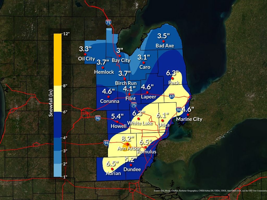
Heavy snowfall occurred midday Wednesday with strong frontogenetic circulations, elevated instability through the DGZ, and deformation forcing which produced large fluffy snowflakes and snowfall rates near one inch per hour at times. Thunder snow was observed just to the east over southern Lake St. Clair during the heaviest snowfall as the surface low approached Lake Erie Wednesday afternoon. Activity diminished quickly Wednesday evening as stabilization settled in behind the departing system which brought an abrupt end to the snow for most locations by 7 PM. Lake effect snow showers impacted portions of The Thumb and southern Huron shoreline areas into the overnight hours. Overall snow accumulations ranged from four to nine inches across the Winter Storm Warning area while amounts between two and four inches were realized elsewhere
Snow Totals
STORM TOTAL SNOW REPORTS

Location                  Snowfall     Duration
                          (Inches)      (Hours)        Lat       Lon

...Lenawee County...
   Adrian                  M   5.2            M     41.90N    84.04W
   Morenci                 M   6.0            M     41.72N    84.22W
   Sand Creek              M   7.0           13     41.83N    84.10W
   Tecumseh                M   7.0           13     42.01N    83.94W
   Onsted                  M   8.0           13     42.01N    84.19W

...Monroe County...
   Temperance              M   4.0            M     41.77N    83.57W
   Dundee                  M   5.2            M     41.96N    83.66W
   1 SSW Ottawa Lake       M   5.8            M     41.75N    83.76W

...Washtenaw County...
   Manchester              M   5.9            M     42.15N    84.04W
   Ene Dexter              M   6.0            M     42.33N    83.88W
   5 NE Clinton            M   6.2            M     42.12N    83.90W
   5 W Plymouth            M   8.0            M     42.37N    83.57W
   2 WNW Ann Arbor         M   8.1            M     42.29N    83.77W
   Manchester              M   8.1           13     42.15N    84.04W
   4 SW Saline             M   8.4            M     42.13N    83.84W
   Ann Arbor               M   8.8            M     42.28N    83.73W

...Wayne County...
   2 NE Livonia            M   5.5            M     42.42N    83.34W
   1 NW Dearborn Heights   M   6.2            M     42.34N    83.29W
   2 NNW Livonia           M   6.7            M     42.42N    83.39W
   Romulus                 M   6.5            M     42.22N    83.37W

...Livingston County...
   1 N Whitmore Lake       M   4.8            M     42.44N    83.75W
   Howell                  M   5.4            M     42.61N    83.94W

...Oakland County...
   5 E Holly               M   4.2            M     42.80N    83.52W
   2 S Ortonville          M   4.6            M     42.82N    83.44W
   E White Lake            M   5.7            M     42.65N    83.50W
   1 SW Clarkston          M   5.9            M     42.73N    83.43W
   3 S Bloomfield Township M   6.0            M     42.53N    83.26W
   4 E White Lake          M   6.1            M     42.65N    83.43W
   Farmington              M   6.2            M     42.46N    83.38W
   2 NNW Wixom             M   6.4            M     42.55N    83.55W
   1 ENE Lake Orion        M   7.2            M     42.79N    83.23W

...Macomb County...
   Mount Clemens           M   4.9            M     42.60N    82.88W
   1 ENE Roseville         M   5.3            M     42.51N    82.92W
   2 NNE Sterling Heights  M   7.0            M     42.61N    83.02W
   Shelby Township         M   7.3            M     42.67N    83.03W
   Sse Shelby Township     M   7.3            M     42.67N    83.03W
   Nnw Richmond            M   7.6            M     42.81N    82.75W

...Shiawassee County...
   Durand                  M   4.0            M     42.91N    83.99W
   Owosso                  M   4.3            M     43.00N    84.18W
   6 WNW Durand            M   4.5            M     42.95N    84.10W

...Genesee County...
   4 SSW Flint             M   3.8            M     42.97N    83.72W
   Burton                  M   3.8            M     43.00N    83.62W
   Grand Blanc             M   3.8            M     42.93N    83.62W
   4 N Burton              M   4.1            M     43.05N    83.62W
   2 SE Grand Blanc        M   4.9            M     42.91N    83.59W

...Lapeer County...
   Lapeer                  M   3.0            M     43.05N    83.32W
   Lapeer                  M   3.3            M     43.05N    83.32W

...St. Clair County...
   Algonac                 M   5.0            M     42.62N    82.53W
   Port Huron              M   5.1            M     42.99N    82.43W
   2 W Port Huron          M   7.0           12     42.99N    82.47W
   2 S Adair               M   8.0            M     42.77N    82.63W

...Saginaw County...
   4 S Auburn              M   2.9            M     43.54N    84.08W
   Saginaw                 M   3.0            M     43.42N    83.95W

...Tuscola County...
   Caro                    M   2.5            M     43.49N    83.40W
   Vassar                  M   3.0            M     43.37N    83.58W
   Cass City               M   3.5            M     43.60N    83.18W

...Sanilac County...
   Roseburg                M   6.0           12     43.19N    82.74W
   Croswell                M   6.8           12     43.27N    82.62W

...Midland County...
   Oil City                M   3.1            M     43.61N    84.59W
   4 SE Midland            M   3.4           12     43.58N    84.17W

...Bay County...
   Auburn                  M   3.6            M     43.60N    84.08W

...Huron County...
   5 NNW Filion            M   3.4            M     43.96N    83.04W
   Bad Axe                 M   3.7            M     43.80N    83.00W
   Port Austin             M   4.0            M     44.04N    83.00W


M = Measured
E = Estimated

$$
Radar
 |
| Radar: NEXRAD mosaic base reflectivity radar loop from 11:30 PM Jan 24, 2023 through 8 PM Jan 25, 2023. |
Environment
|
|
|
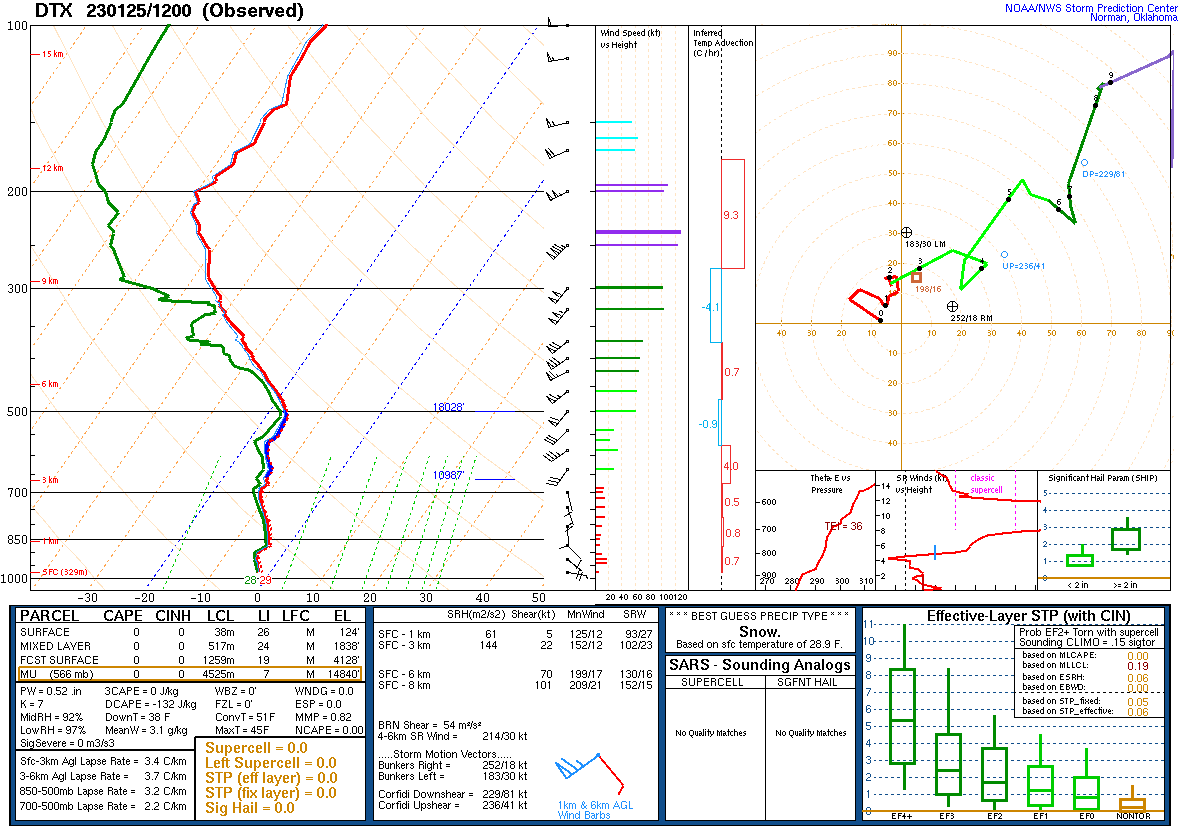
| Figure 1: 12z DTX Sounding | Figure: WPC surface analysis map at 1 PM Jan 25, 2023. |
 |
Figure: 300 mb level height (black contours - m MSL), wind speed (fill - knots), and convergence (pink contours - 10^-5/s) at 1 PM Jan 25, 2023. |
 |
|
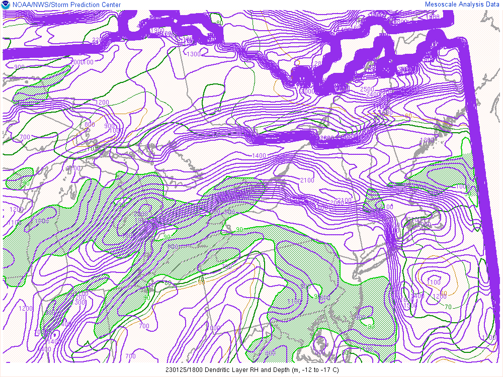
| Figure: Dendritic Growth Zone (-12C to -17Z) depth (contour - m) & RH (fill - %) at 1 PM Jan 25, 2023. | Figure: Mid-level (700-500 mb) lapse rates (contour - J/kg) at 3 PM Jan 25, 2023. |
 |
Media use of NWS Web News Stories is encouraged! Please acknowledge the NWS as the source of any news information accessed from this site. |
|