Overview
Event Summary
A powerful arctic cold front surged across the Midwest eventually reaching Michigan by late day Thursday December 22nd. As this occurred, low pressure began to develop along the front over the northern Ohio Valley. This low rapidly deepened, undergoing bombogenesis, as it lifted through the central Great Lakes into southern Ontario Friday December 23rd. System slowly drifted north over the remainder of the weekend maintaining the extremely tight pressure gradient over the region resulting in a long duration of strong winds and a robust lake effect response.
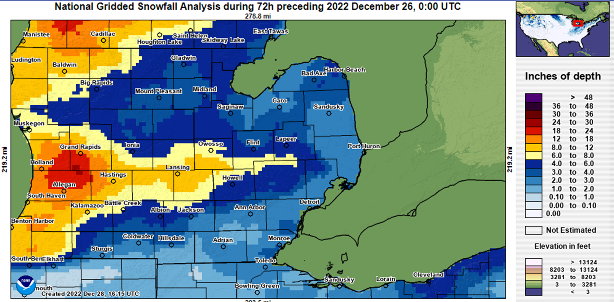
The bulk of initial precipitation ahead of the arctic cold front fell as rain before rapidly transitioning to snow in the immediate wake of the frontal passage. This combined with the progressive nature of the low limited snow with the multiday scattered lake effect snow showers instead generating the bulk of snowfall amounts seen (see Snowfall tab for 3 day totals).
Rather, the primary impact of this system was the wind and cold. Temperatures rapidly fell overnight Dec 22nd into the morning of Dec 23rd with all of southeast Michigan seeing a 35-40° temperature drop resulting in a flash freeze of earlier rainfall. For example: Detroit Metro Airport went form 40°F at 11pm Dec 22 to 1°F 10am Dec 23. The still 'warm' (relatively speaking) Lake Michigan helped to blunt this airmass keeping the core of the arctic airmass to our south over the Ohio Valley. That said, temperatures remained in the single digits (both positive & negative) to positive low teens from Dec 23-25, which combined with wind gusts of 35-60mph (see Wind tab for reports), resulted in windchills ranging from the positive single digits to negative teens.
Radar
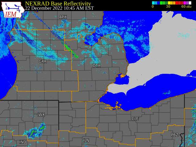 |
|
Radar loop from 10am Thursday December 22 to 9am Sunday December 25, 2022 Arctic cold front crosses the region late Dec 22nd switching over any regions still experiencing rain to all snow with light snow continuing into the morning of Dec 23rd. Lake effect snow then ramps up over the 23rd and continues into Dec 25th. |
Wind
Public Information Statement
National Weather Service Detroit/Pontiac MI
906 AM EST Sat Dec 24 2022

The following are peak wind gusts of 30 mph or more from across the
region reported to the National Weather Service in White Lake over
the past 24 hours (9am Dec 23 - 9am Dec 24).

Port Hope                        58 mph     508 PM...
Saginaw Tri Cities Airport       56 mph     240 PM...
Flint                            54 mph     1127 AM...
Pontiac                          53 mph     443 PM...
Ypsilanti                        52 mph     137 PM...
Detroit City Airport             49 mph     453 PM...
Detroit Metro Airport            48 mph     603 PM...
Adrian                           48 mph     204 PM...
Ann Arbor                        47 mph     130 PM...
Bad Axe                          46 mph     535 PM...
Saginaw Harry Browne             46 mph     715 PM...
Owosso                           44 mph     1215 PM...
Lapeer                           44 mph     1215 PM...
Mount Clemens                    43 mph     718 PM...
Caro                             41 mph     655 PM...
Howell                           40 mph     235 PM...
Grosse Ile                       40 mph     255 PM...
Troy                             39 mph     1055 AM...
Midland                          37 mph     1135 AM...
Port Huron                       37 mph     235 PM...
Lambertville                     37 mph     935 PM...
Snowfall
Public Information Statement
National Weather Service Detroit/Pontiac MI
1147 AM EST Sun Dec 25 2022


SNOW REPORTS... Covering the period from 9am Dec 22 to 9am Dec 25- this includes both snow from the low and subsequent lake effect.

NOTE: Due to the high winds throughout much of the event, variation in amounts over relatively short distances can be expected.


Location                  Snowfall     Duration
                          (Inches)      (Hours)        Lat       Lon

...Bay County...
   Auburn                  M   5.3           72     43.60N    84.08W

...Genesee County...
   4 N Goodrich            M   3.9           72     42.97N    83.51W
   5 SSW Flint             M   6.3           72     42.97N    83.74W

...Huron County...
   Bad Axe                 M   2.8           72     43.80N    83.00W
   5 NNW Filion            M   3.2           72     43.96N    83.04W

...Lapeer County...
   Lapeer                  M   8.3           72     43.05N    83.32W

...Livingston County...
   1 NE Howell             M   5.9           72     42.62N    83.92W

...Oakland County...
   Farmington              M   2.8           72     42.46N    83.38W
   4 E White Lake          M   4.1           72     42.65N    83.43W

...Saginaw County...
   5 S Auburn              M   3.9           72     43.53N    84.08W

...Shiawassee County...
   Durand                  M   5.5           72     42.91N    83.99W
   Owosso                  M   8.5           72     43.00N    84.18W

...Tuscola County...
   Cass City               M   2.0           72     43.60N    83.18W
   Vassar                  M   3.8           72     43.37N    83.58W

...Washtenaw County...
   Ann Arbor               M   5.2           72     42.28N    83.73W

...Wayne County...
   Dearborn                M   2.6           72     42.31N    83.21W
   Garden City             M   4.0           72     42.33N    83.33W
   Grosse Pointe Farms     M   3.2           72     42.40N    82.89W
   1 SE Romulus            M   4.6           72     42.21N    83.35W
   Wyandotte               M   4.2           72     42.21N    83.16W


M = Measured
E = Estimated

$$
 |
Media use of NWS Web News Stories is encouraged! Please acknowledge the NWS as the source of any news information accessed from this site. |
|

