| Overview | Radar |
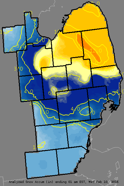
A low pressure system moved across the northern Great Lakes on Monday, February 8th. This low stalled over southern Lake Huron during the early morning hours of February 9, strengthening as it did so. Snow showers with embedded heavier squalls tracked southward through Southeast Michigan overnight with mainly 1-4" by 7 am. The low continued to only slowly drift eastward, resulting in a long period of snowfall throughout the day. The Thumb was the hardest-hit by this activity, with 8-12" widespread across the region. The heaviest amounts occurred in Huron county and in a band over northwest Tuscola and western Sanilac Counties.
Back to top
Radar loop
.gif) |
| Radar loop courtesy of Iowa Environmental Mesonet (IEM). |
|
|
LOCATION                  SNOWFALL     DURATION
                          (INCHES)      (HOURS)        LAT       LON

...BAY COUNTY...
   BAY CITY                M   4.3           17     43.59N    83.89W

...GENESEE COUNTY...
   FLINT                   M   5.7         15.5     43.02N    83.69W
   5 N DAVISON             M   6.0           17     43.10N    83.52W
   FLINT                   M   6.6           19     43.02N    83.69W
   CLIO                    E   7.0           16     43.18N    83.74W

...HURON COUNTY...
   BAD AXE                 E   8.0           20     43.80N    83.00W
   HARBOR BEACH            M   9.5           21     43.85N    82.65W
   PIGEON                  M  10.5           21     43.83N    83.27W
   SEBEWAING               E  11.0           22     43.73N    83.45W
   PORT HOPE               E  12.0           21     43.94N    82.72W

...LAPEER COUNTY...
   LAPEER                  M   6.0           16     43.05N    83.32W

...LENAWEE COUNTY...
   ADRIAN                  E   2.0           16     41.90N    84.04W

...LIVINGSTON COUNTY...
   FOWLERVILLE             M   1.0           17     42.66N    84.07W
   HOWELL                  E   3.0         16.5     42.61N    83.94W

...MACOMB COUNTY...
   CLINTON TOWNSHIP        M   1.5           17     42.59N    82.92W

...MIDLAND COUNTY...
   MIDLAND                 M   2.5           18     43.62N    84.23W

...MONROE COUNTY...
   MONROE                  E   1.0           16     41.92N    83.39W

...OAKLAND COUNTY...
   MILFORD                 M   2.8           18     42.59N    83.60W
   LAKE ORION              M   4.6           19     42.78N    83.24W
   WHITE LAKE              M   5.0           20     42.65N    83.50W

...SAGINAW COUNTY...
   HEMLOCK                 M   3.7           19     43.42N    84.23W
   BRIDGEPORT              M   5.1           19     43.38N    83.88W
   2 NW SAGINAW            M   6.5           19     43.44N    83.98W
   1 S BIRCH RUN           M   8.8           16     43.24N    83.79W

...SANILAC COUNTY...
   MARLETTE                M   9.0           18     43.33N    83.08W
   SANDUSKY                M  10.0           18     43.42N    82.83W
   2 E NEW GREENLEAF       E  12.0           20     43.66N    83.04W
   2 W PECK                M  12.0           20     43.26N    82.86W

...SHIAWASSEE COUNTY...
   CORUNNA                 M   4.3           20     42.98N    84.12W

...ST. CLAIR COUNTY...
   COLUMBUS                M   2.5         15.5     42.89N    82.67W
   FORT GRATIOT            E   5.0           17     43.01N    82.43W
   LAKEPORT                M   8.0           18     43.12N    82.50W
   YALE                    M   8.0           16     43.13N    82.80W

...TUSCOLA COUNTY...
   CARO                    M   8.5           17     43.49N    83.40W
   KINGSTON                E   9.0           17     43.41N    83.19W
   CASS CITY               E  12.0           17     43.60N    83.18W
   DEFORD                  E  14.0           19     43.51N    83.19W

...WASHTENAW COUNTY...
   ANN ARBOR               M   1.8           14     42.28N    83.73W

...WAYNE COUNTY...
   ROMULUS                 M   2.0           14     42.22N    83.37W


M = MEASURED
E = ESTIMATED
Back to top

