Overview
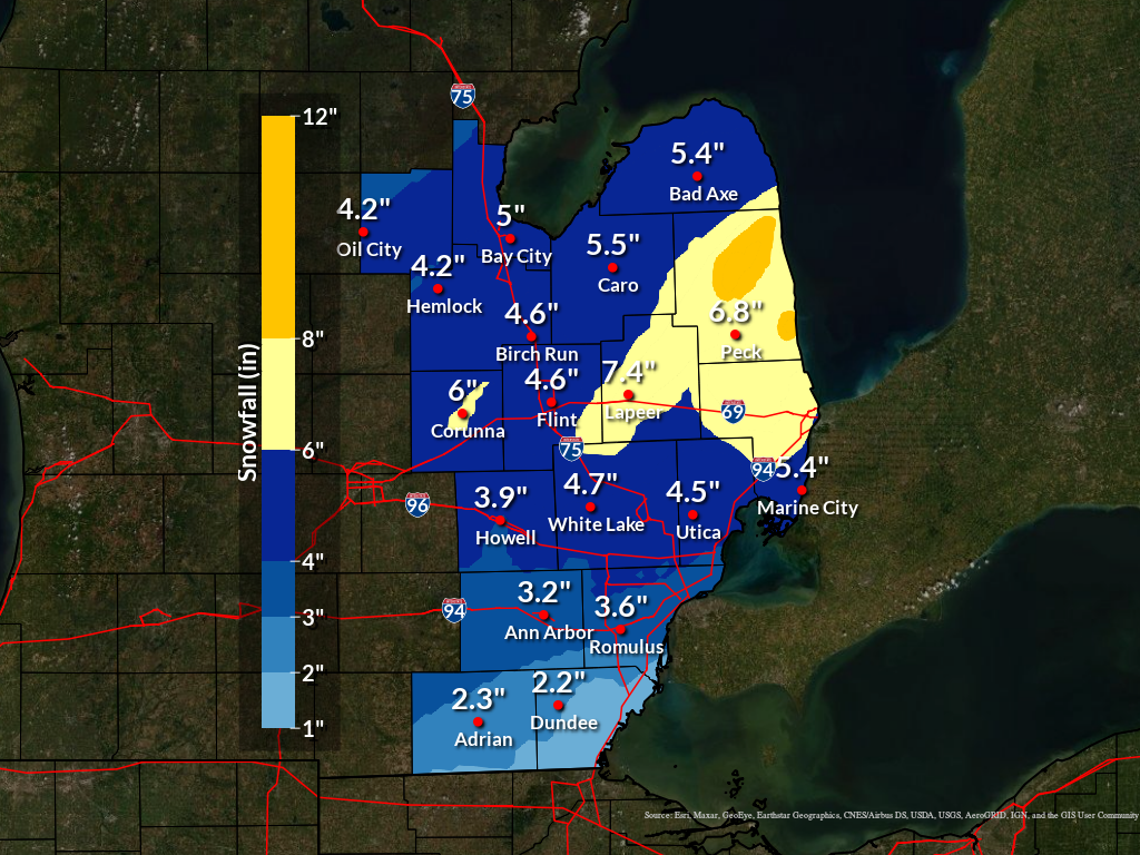
Low pressure tracking through northwest Ohio and into the Eastern Great Lakes produced 3 to 6 inches of snow across most of southeast Michigan Wednesday (Feb 12) afternoon through early Thursday (Feb 13) morning. Sleet and freezing drizzle was mixed in, along and south of I-94, which limited snowfall amounts. With northeast winds off Lake Huron, higher snow totals were observed over the eastern Thumb region, with localized amounts of 7-10 inches. Snow developed Wednesday afternoon and tapered off by 3 AM Thursday, thus road crews were able to clear much of the main roads for the Thursday morning commute. The snow also contained less water content than normal, thus was easier to shovel as well.
Snow Totals
Public Information Statement...Summary
National Weather Service Detroit/Pontiac MI
1135 AM EST Thu Feb 13 2025


STORM TOTAL SNOW REPORTS

Location                  Snowfall     Duration
                          (Inches)      (Hours)        Lat       Lon

...Bay County...
   Bay City                M   4.8           11     43.59N    83.89W

...Genesee County...
   Linden                  M   4.5           12     42.82N    83.78W
   Flint                   M   4.6           11     43.02N    83.69W
   Goodrich                M   4.8           12     42.92N    83.51W
   5 SE Birch Run          M   5.2           10     43.20N    83.72W
   Davison                 M   5.5           11     43.03N    83.52W
   3 S Grand Blanc         M   5.8           11     42.88N    83.62W
   Grand Blanc             M   6.0           11     42.93N    83.62W
   Burton                  M   6.1           12     43.00N    83.62W

...Huron County...
   Bad Axe                 M   4.1           11     43.80N    83.00W
   Harbor Beach            M   5.5           12     43.85N    82.65W

...Lapeer County...
   North Branch            M   6.0           12     43.23N    83.19W
   5 W Lapeer              M   6.5           11     43.05N    83.42W
   Lapeer                  M   7.2           12     43.05N    83.32W

...Lenawee County...
   Morenci                 M   2.0           11     41.72N    84.22W

...Livingston County...
   Pinckney                M   3.6           11     42.45N    83.95W
   Howell                  M   4.0           12     42.61N    83.94W
   Whitmore Lake           M   4.7           12     42.44N    83.74W

...Macomb County...
   Clinton Township        M   4.0           11     42.59N    82.92W
   New Baltimore           M   4.0           12     42.68N    82.74W
   1 SW Sc S Harbor        M   4.3           12     42.46N    82.89W
   Washington              M   4.8           12     42.72N    83.04W
   Shelby Township         M   6.0           12     42.67N    83.03W

...Monroe County...
   Monroe                  M   1.7           11     41.92N    83.39W

...Oakland County...
   Farmington              M   3.2           12     42.46N    83.38W
   Beverly Hills           M   3.3           12     42.52N    83.22W
   Bloomfield Hills        M   3.8           12     42.58N    83.25W
   Berkley                 M   4.1           12     42.50N    83.18W
   2 SW Wolverine Lake     M   4.5           12     42.54N    83.50W
   Leonard                 M   4.5           11     42.87N    83.14W
   Royal Oak               M   4.5           11     42.51N    83.15W
   Lake Orion              M   5.4           12     42.78N    83.24W

...Saginaw County...
   Chesaning               M   4.0           12     43.18N    84.12W
   Oakley                  M   4.5           11     43.14N    84.17W
   Shields                 M   4.8           11     43.42N    84.07W
   Frankenmuth             M   5.0           11     43.33N    83.74W

...Sanilac County...
   Sandusky                M   5.9           12     43.42N    82.83W
   2 W Peck                M   6.5           12     43.26N    82.86W
   Palms                   M   9.0           12     43.61N    82.77W
   Deckerville             M  10.0           12     43.53N    82.74W
   Lexington               M  10.5           12     43.27N    82.53W

...Shiawassee County...
   2 W Perry               M   5.7           12     42.82N    84.27W
   Perry                   M   7.0           11     42.82N    84.23W

...St. Clair County...
   Kimball                 M   6.0           12     42.95N    82.56W
   Lakeport                M   6.3           12     43.12N    82.50W
   Columbus                M   6.5           12     42.88N    82.66W

...Tuscola County...
   Cass City               M   4.5           12     43.60N    83.18W
   Millington              M   4.5           11     43.28N    83.53W
   Caro                    M   5.3           12     43.49N    83.40W

...Washtenaw County...
   2 SE Ypsilanti          M   3.0           11     42.22N    83.59W
   Manchester              M   3.2           11     42.15N    84.04W
   Se Ann Arbor            M   3.2           12     42.28N    83.73W
   Ann Arbor               M   3.6           12     42.28N    83.73W

...Wayne County...
   2 NW Woodhaven          M   3.0           11     42.15N    83.27W
   Riverview               M   3.0           11     42.17N    83.19W
   Livonia                 M   3.1           11     42.40N    83.37W
   Detroit                 M   3.2           11     42.33N    83.05W
   Canton                  M   3.3           11     42.31N    83.48W
   2 S Southwest Detroit   M   3.5           11     42.31N    83.10W
   Plymouth                M   3.5           12     42.37N    83.47W
   2 SE Romulus            M   3.6           12     42.20N    83.34W
   Grosse Pointe Farms     M   4.0           12     42.41N    82.89W


M = Measured
E = Estimated

$$
|
|
|
Estimated snowfall totals across Southeast Michigan from the February 12-13 2025 storm. |
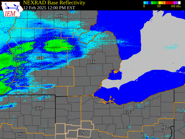
Radar
|
|
|
Radar: NEXRAD mosaic base reflectivity radar loop from February 12-13, 2025 |
Radar loop courtesy of Iowa Environmental Mesonet (IEM)
 |
Media use of NWS Web News Stories is encouraged! Please acknowledge the NWS as the source of any news information accessed from this site. |
|