Our projected Thanksgiving Weekend storm of present day takes me back in time to a "super-snowstorm" that occurred during my first year with the NWS back on the Thanksgiving weekend of 1974. Ironically that storm too, moved into the area on the busy travel day, the Sunday after Thanksgiving. The storm came in during the pre-dawn hours of Sunday rather than later in the day and was a date later - December 1st, 1974. Enjoy snowlovers!
THANKSGIVING WEEKEND SUPER SNOWSTORM OF 1974
Written by: Bill Deedler, Weather Historian, National Weather Service White Lake, Mi
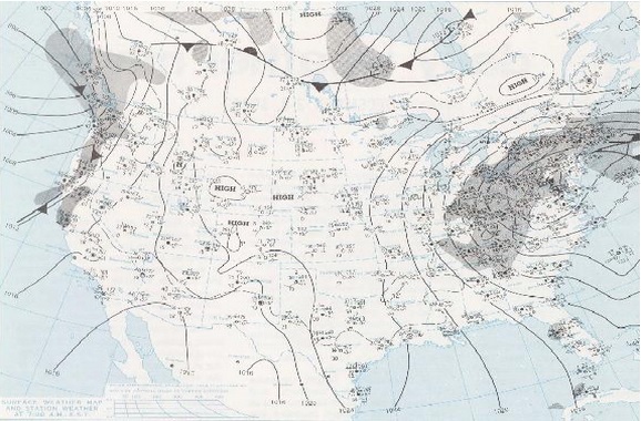
The development and track of this super snowstorm was complicated and quite a hassle for forecasters that Thanksgiving weekend. The primitive forecast models (when compared to the more sophisticated and better resolution of today's models) had quite a time in predicting the track of the storm and its intensity. Even up to the day of the storm, the forecast models continued to weaken the center of the storm as it moved into Kentucky and Ohio, while intensifying a new storm along the East coast. On Saturday, November 30th, a strong closed-off 500 MB Low advanced into the Mid-Mississippi Valley, while at the same time, at the surface, an inverted trough of low pressure extended from a low over the northern Gulf of America, north northwest to a second low over Missouri. The consensus of the forecast models was to bring the 500 MB and surface low generally east, into the Ohio Valley and weakening both. In the meantime, the Gulf Low was forecast to track north northeast up the East Coast and intensify; thus, becoming the main low and storm center of the entire system. This was the accepted forecast scenario with the data available at the time and could hardly be argued otherwise. Actually, this predicted path and subsequent weakening of the Ohio Valley low as the East Coast storm intensifies or "bombs-out" is what generally happens. The models failed in forecasting the weakening trend of the Ohio Valley system. The 500 MB Low and the surface low not only did not weaken, they actually intensified and became vertically stacked in the atmosphere. Generally, when this happens the system tends to hold on to its intensity longer and slow down in movement, both of which proved detrimental to the computer forecast.
Light snow moved into extreme Southeast Lower Michigan during the predawn hours between 5:00 AM and 7:00 AM. Even at the 5:00 AM forecast issuance, it looked as if just one to three inches of snow would blanket extreme Southeast Lower Michigan for this event. However, by sunrise, already up to three inches of snow covered the region and the snow was not getting any lighter. A stiff northeaster' also accompanied this storm, though not as severely as the 1886 storm, averaging 20 to 30 mph with gusts above 30 mph. By sunrise, an area of snow had settled over extreme Southeast Lower Michigan. On radar during the forenoon hours, bands of heavier snow appeared over Northern Ohio and Lake Erie, trekking west-northwest toward Michigan. By now, the forecasters knew the forecast was in trouble and updated the forecast to read "six or more" inches of snow.
The 500 MB Low and associated energy to support the surface system drifted east over Kentucky, while the surface low that was over Missouri drifted east right along with it. A huge conveyor belt of moisture had set up in the atmosphere extending from the Gulf of America and the Western Atlantic, east into the Ohio Valley and Southern Great Lakes. Not only had the storm tapped the usual Gulf moisture; now Atlantic moisture started to be drawn into the mix. After analyzing surface data from the 1886 storm, it is strongly suspected that this too was the case at that time. Huge moisture plumes from both the Atlantic and Gulf of America fed the1974 storm and likely, the1886 storm, with nearly duplicate surface observations before and during the event.
Bands of snow (much of it moderate to heavy) continued to be produced across the Eastern Great Lake States on the "conveyor-belt" through the afternoon, with the heaviest snow falling across extreme Southern Ontario, extreme Southeast Lower Michigan and extreme Northwest Ohio. By mid afternoon, already between six and ten inches of snow was on ground across much of extreme Southeast Lower Michigan, with generally eight to ten inches in the metro Detroit area. Visibilities were frequently near zero and moderate northeast winds blew the heavy, wet snow into at least three to five foot drifts. Another notable item observed during the storm was frequency of large snow flakes. Generally in the majority of snowstorms there may be a period or two of heavy snow with large flakes and a quick accumulation of snow. During this storm however, there were several periods, or waves, of heavy snow with continuous large flakes and very low visibilities, migrating in from the east over the region.
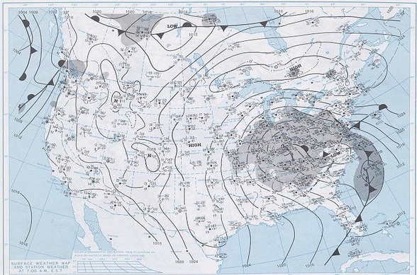
The surface low drifted north northeast from Kentucky into West Virginia by Sunday evening on the 1st and gradually matured and occluded. It still remained however, the dominant low (which was not forecasted by the forecast models), while the second low on east coast moved north at the triple point (at the point where the occluded, warm and cold front of the system met) and never really developed. As darkness fell, generally up to a foot and a half of snow smothered the metro Detroit area, with six to twelve inches elsewhere in extreme Southeast Lower Michigan. During the evening the snowfall became lighter and by midnight, 18.4" was officially observed at Detroit Metro Airport. Another nine tenths of an inch fell early on the 2nd, for a grand total of 19.3" (19.2" of it falling in 24 hours) with Flint reporting a snowstorm total of 8.1". As the low drifted northward, milder air filtered into the region and the snow became mixed with, and then changed to drizzle.
Surface Maps below are from 7am Sun 12/1/74 and 7am Mon 12/2/74, it's a shame the Sun 1pm is not available as that's when the heaviest snow was falling (we are talking several hours of 1/4 mile vsby or less)! You can also see by the maps, only the Southeast portion of the state was affected with the heaviest /near 20"/ in the Detroit Metro area!

