Detroit/Pontiac, MI
Weather Forecast Office
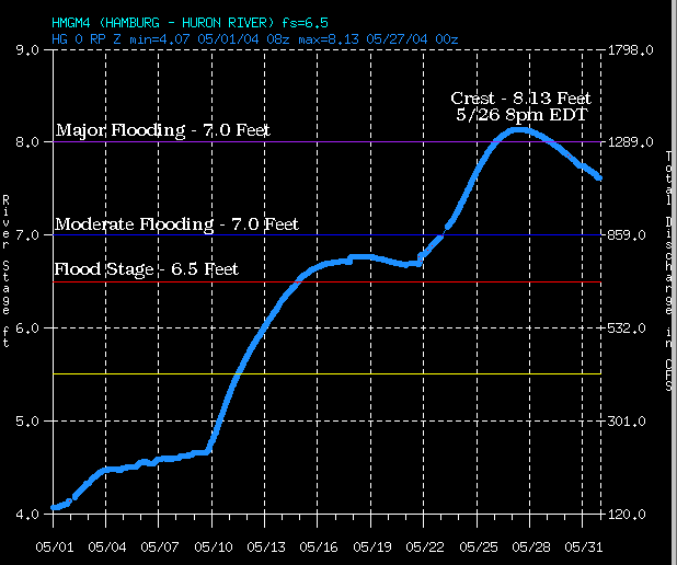
The image above is a hydrograph (a graph of river stages) for the Huron River at Hamburg for the month of May 2004. The graph shows the response of the river to the record monthly rainfall that fell across the Huron River basin. The river crested at 8.13 feet, or 1.63 feet above the floodstage of 6.5 feet. A current hydrograph is available from the NWS Advanced Hydrologic Prediction Service.
The crest of 8.13 feet is the third highest crest recorded for the Huron River at Hamburg. The two higher crests were 8.46 feet on June 30th, 1968; and 8.35 feet on May 15th, 1956. Records for this site go back to October 1951.
The following images are of flooding along the Huron River and Orr Lake near Hamburg. They were taken May 26th, 2004, just before the river crested. Click on the thumbnail to view a larger image. Images courtesy of Danny Costello, National Weather Service.
 |
 |
 |
 |
Weather Forecasts
Fire Weather
Snowfall Forecast
Marine Forecast
Beach Forecast
Aviation
Digital Forecast Graphics
Current Weather Conditions
Local Observations
Today's Weather History
Observed Snowfall
Regional Radar Mosaic
Past Weather Records
Climate records by month
Additional Daily Climate Data
Top 20 Lists
Breakdown by Decade
Largest Snowstorms
Season Snowfall Maps
Year To Date Plots
Severe Weather
Daily Plots
Annual Plots
Event Summaries
US Dept of Commerce
National Oceanic and Atmospheric Administration
National Weather Service
Detroit/Pontiac, MI
9200 White Lake Road
White Lake, MI 48386
248-620-9804
Comments? Questions? Please Contact Us.

