Overview
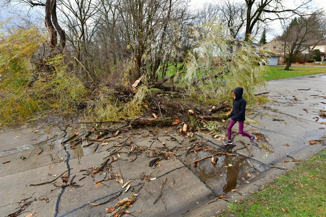
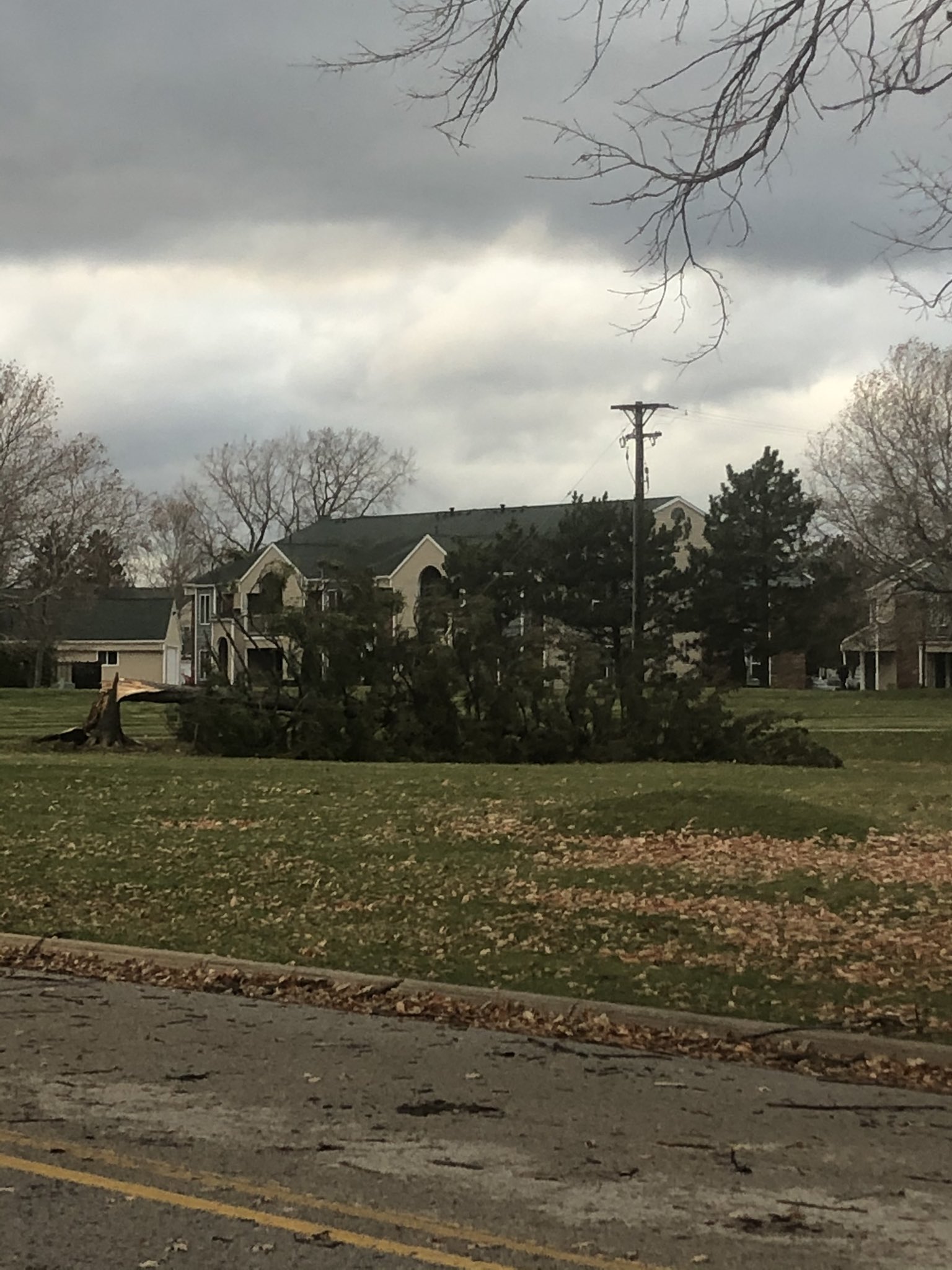
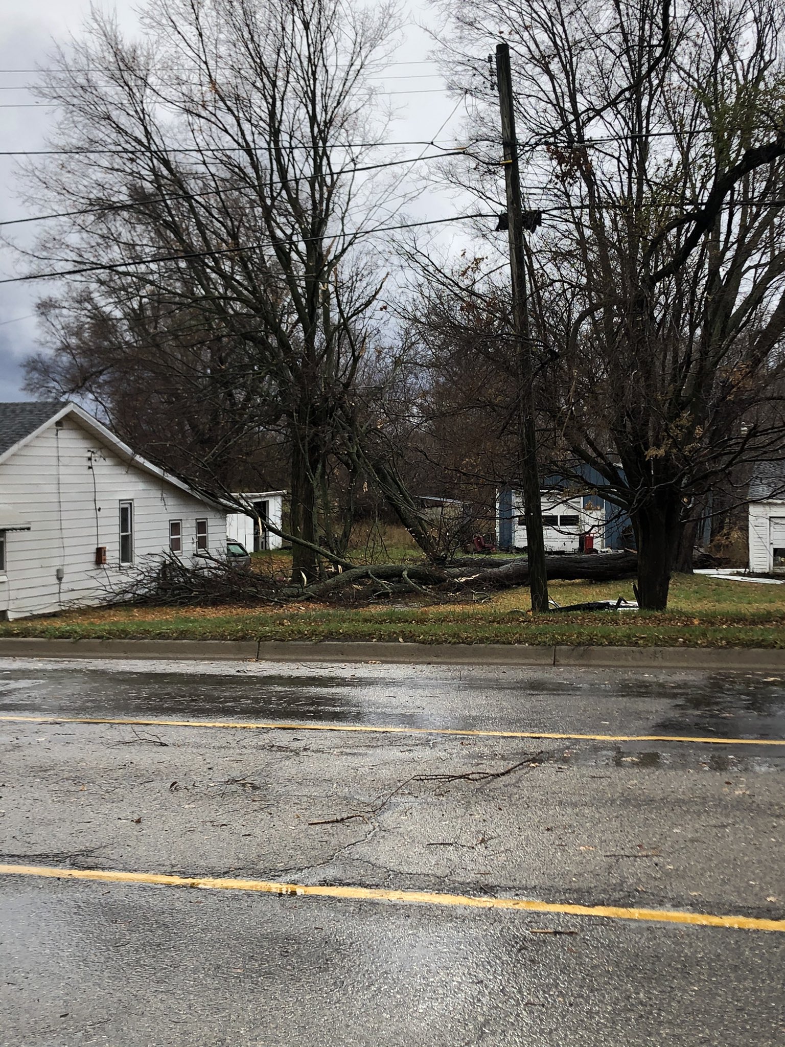
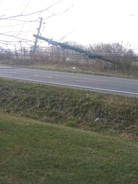
A strong low pressure system developed over the Midwest and swept across the Great Lakes on November 15, 2020. Widespread showers and a few thunderstorms occurred the night before as the warm front lifted through, but the main impact from this system was the wind. A line of gusty showers and thunderstorms accompanied the strong cold front that pushed across lower Michigan and ushered in an afternoon and evening of strong, long-lived gusty winds for which a High Wind Warning was in effect. Gusts of 40 to 50 mph were common while numerous gusts above 60 mph were also measured. Widespread damage to trees and power lines occurred and about 370,000 customers lost power across Lower Michigan.
Photos
 |
 |
 |
|
Farmington Hills, MI Credit: The Detroit News (David Guralnick) |
Port Huron, MI Credit: Matt Markham |
Fowlerville, MI Credit: Isaac Polanski |
 |
 |
|
|
New Balitmore, MI Credit: The Macomb Daily |
Monroe, MI Credit: Brian Stinnett |
Storm Reports
 |
|
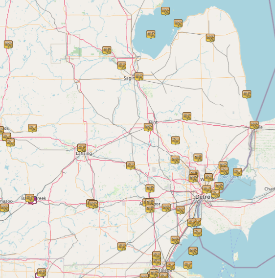
Map of Local Storm Reports
|
Severe Weather Local Storm Reports:
PRELIMINARY LOCAL STORM REPORT...SUMMARY
NATIONAL WEATHER SERVICE DETROIT/PONTIAC MI
1042 AM EST MON NOV 16 2020

..TIME...   ...EVENT...      ...CITY LOCATION...     ...LAT.LON...
..DATE...   ....MAG....      ..COUNTY LOCATION..ST.. ...SOURCE....
            ..REMARKS..

1127 AM     NON-TSTM WND GST 5 S CLARKSTON           42.67N 83.42W
11/15/2020  M55.00 MPH       OAKLAND            MI   ASOS

            MEASURED AT OAKLAND COUNTY INTERNATIONAL AIRPORT.

1130 AM     MARINE TSTM WIND 5 E ESTRAL BEACH        42.00N 83.14W
11/15/2020  M60.00 MPH       LEZ444             MI   MESONET

            MARINE THUNDERSTORM WIND GUST OF 50 KNOTS MEASURED AT
            DETROIT RIVER LIGHT.

1135 AM     NON-TSTM WND GST 5 WSW TEMPERANCE        41.73N 83.65W
11/15/2020  M47.00 MPH       MONROE             MI   AWOS

            MEASURED AT LAMBERTVILLE AWOS.

1150 AM     MARINE TSTM WIND 9 SSE STONY POINT       41.83N 83.19W
11/15/2020  M47.00 MPH       LEZ162             MI   BUOY

            MARINE THUNDERSTORM WIND GUST OF 41 KNOTS MEASURED AT
            TOLEDO LIGHT.

1155 AM     NON-TSTM WND GST 3 SW TROY               42.54N 83.18W
11/15/2020  M65.00 MPH       OAKLAND            MI   AWOS

            MEASURED AT OAKLAND/TROY AIRPORT.

1159 AM     NON-TSTM WND GST 5 ENE DETROIT           42.40N 83.02W
11/15/2020  M58.00 MPH       WAYNE              MI   ASOS

            MEASURED AT DETROIT CITY AIRPORT.

1200 PM     NON-TSTM WND DMG PORT HURON              42.99N 82.43W
11/15/2020                   ST. CLAIR          MI   PUBLIC

            SEVERAL LARGE TREES DOWN THROUGHOUT THE CITY DUE TO HIGH
            WIND GUSTS.

1250 PM     NON-TSTM WND GST 5 E ESTRAL BEACH        42.00N 83.14W
11/15/2020  M70.00 MPH       LEZ444             MI   BUOY

            MARINE WIND GUST OF 61 KNOTS MEASURED AT DETROIT RIVER
            LIGHT.

1250 PM     NON-TSTM WND GST 4 WNW TEMPERANCE        41.79N 83.65W
11/15/2020  M48.00 MPH       MONROE             MI   MESONET

1251 PM     NON-TSTM WND GST 1 SE ROMULUS            42.21N 83.35W
11/15/2020  M61.00 MPH       WAYNE              MI   ASOS

            MEASURED AT DETROIT METRO AIRPORT.

1255 PM     NON-TSTM WND GST 4 NNW MIDLAND           43.67N 84.27W
11/15/2020  M46.00 MPH       MIDLAND            MI   AWOS

0100 PM     NON-TSTM WND DMG ANN ARBOR               42.28N 83.73W
11/15/2020                   WASHTENAW          MI   PUBLIC

            SEVERAL LARGE LIMBS DOWN DUE TO HIGH WIND GUSTS. TIME
            ESTIMATED FROM PEAK WIND OBSERVATION AT ANN ARBOR AIRPORT
            DUE TO EXTENDED PERIOD OF HIGH WINDS AND DELAYED
            REPORTING OF DAMAGE.

0100 PM     NON-TSTM WND GST 9 SSE STONY POINT       41.83N 83.19W
11/15/2020  M62.00 MPH       LEZ162             MI   BUOY

            MARINE WIND GUST OF 54 KNOTS MEASURED AT TOLEDO LIGHT.

0100 PM     NON-TSTM WND GST 2 W ANN ARBOR           42.28N 83.77W
11/15/2020  M48.00 MPH       WASHTENAW          MI   MESONET

0100 PM     NON-TSTM WND GST 1 SE WHITMORE LAKE      42.41N 83.73W
11/15/2020  M47.00 MPH       WASHTENAW          MI   MESONET

0100 PM     NON-TSTM WND DMG N BERKLEY               42.50N 83.19W
11/15/2020                   OAKLAND            MI   TRAINED SPOTTER

            LARGE LIMBS DOWN DUE TO HIGH WINDS RESULTING IN HOME AND
            VEHICLE DAMAGE. TIME ESTIMATED DUE TO EXTENDED PERIOD OF
            HIGH WINDS AND DELAYED REPORTING OF DAMAGE.

0109 PM     NON-TSTM WND GST 4 ENE MOUNT CLEMENS     42.62N 82.82W
11/15/2020  M59.00 MPH       MACOMB             MI   AWOS

            MEASURED AT SELFRIDGE AIR NATIONAL GUARD BASE.

0112 PM     NON-TSTM WND GST 4 NNE GROSSE POINTE     42.43N 82.87W
11/15/2020  M63.00 MPH       LCZ460             MI   MESONET

            MEASURED AT GROSSE POINTE YACHT CLUB.

0115 PM     NON-TSTM WND GST 2 WNW HOWELL            42.62N 83.97W
11/15/2020  M49.00 MPH       LIVINGSTON         MI   AWOS

0120 PM     NON-TSTM WND GST 4 S ANN ARBOR           42.22N 83.73W
11/15/2020  M61.00 MPH       WASHTENAW          MI   ASOS

            MEASURED AT ANN ARBOR AIRPORT.

0123 PM     NON-TSTM WND GST 5 S AUBURN              43.53N 84.08W
11/15/2020  M55.00 MPH       SAGINAW            MI   ASOS

            MEASURED AT TRI-CITIES AIRPORT.

0130 PM     NON-TSTM WND GST 5 ESE MOUNT CLEMENS     42.57N 82.80W
11/15/2020  M58.00 MPH       MACOMB             MI   MESONET

            MEASURED AT LAKE ST. CLAIR METROPARK.

0135 PM     NON-TSTM WND GST 4 ENE SAGINAW           43.43N 83.87W
11/15/2020  M46.00 MPH       SAGINAW            MI   AWOS

            MEASURED AT HARRY BROWNE AIRPORT.

0135 PM     NON-TSTM WND GST 2 NW MONROE             41.93N 83.42W
11/15/2020  M54.00 MPH       MONROE             MI   AWOS

0146 PM     NON-TSTM WND GST 2 E ORTONVILLE          42.85N 83.41W
11/15/2020  M50.00 MPH       OAKLAND            MI   MESONET

0200 PM     NON-TSTM WND DMG 1 WSW ROCHESTER         42.69N 83.13W
11/15/2020                   OAKLAND            MI   PUBLIC

            LARGE TREES DOWN DUE TO HIGH WIND GUSTS. TIME ESTIMATED
            FROM PEAK WIND OBSERVATION AT PONTIAC AIRPORT DUE TO
            EXTENDED PERIOD OF HIGH WINDS AND DELAYED REPORTING OF
            DAMAGE.

0222 PM     NON-TSTM WND GST 4 SW HARSENS ISLAND     42.56N 82.64W
11/15/2020  M58.00 MPH       ST. CLAIR          MI   MESONET

0235 PM     NON-TSTM WND GST 2 SSE BAD AXE           43.78N 82.98W
11/15/2020  M47.00 MPH       HURON              MI   AWOS

0241 PM     NON-TSTM WND GST 2 S GROSSE ILE          42.10N 83.15W
11/15/2020  M47.00 MPH       WAYNE              MI   AWOS

0300 PM     NON-TSTM WND GST 3 ESE FLAT ROCK         42.09N 83.21W
11/15/2020  M47.00 MPH       WAYNE              MI   MESONET

0354 PM     NON-TSTM WND GST 5 E YPSILANTI           42.23N 83.53W
11/15/2020  M60.00 MPH       WAYNE              MI   ASOS

            MEASURED AT WILLOW RUN AIRPORT.

0425 PM     NON-TSTM WND GST 3 SW ADRIAN             41.87N 84.08W
11/15/2020  M60.00 MPH       LENAWEE            MI   ASOS

            MEASURED AT LENAWEE COUNTY AIRPORT.

0429 PM     NON-TSTM WND GST 4 N BAY PORT            43.91N 83.38W
11/15/2020  M54.00 MPH       HURON              MI   MESONET

0434 PM     NON-TSTM WND GST 5 SW FLINT              42.97N 83.75W
11/15/2020  M54.00 MPH       GENESEE            MI   ASOS

            MEASURED AT FLINT AIRPORT.

0440 PM     NON-TSTM WND GST 8 ESE AU GRES           44.02N 83.54W
11/15/2020  M62.00 MPH       LHZ421             MI   BUOY

            MARINE WIND GUST OF 54 KNOTS MEASURED AT GRAVELLY SHOAL
            LIGHT.

0516 PM     NON-TSTM WND GST 2 S GROSSE POINTE       42.36N 82.91W
11/15/2020  M68.00 MPH       LCZ460             MI   BUOY

            MARINE WIND GUST OF 59 KNOTS MEASURED AT PECHE ISLAND
            LIGHT.

0524 PM     NON-TSTM WND GST 3 ENE LAPEER            43.07N 83.27W
11/15/2020  M47.00 MPH       LAPEER             MI   AWOS

0530 PM     NON-TSTM WND GST 6 W ST. CLAIR SHORES    42.51N 83.00W
11/15/2020  M45.00 MPH       MACOMB             MI   MESONET

0550 PM     NON-TSTM WND GST 5 E CROSWELL            43.27N 82.52W
11/15/2020  M53.00 MPH       LHZ443             MI   MESONET

0700 PM     NON-TSTM WND GST 12 NNW BAY PARK         43.81N 83.72W
11/15/2020  M59.00 MPH       LHZ422             MI   BUOY

            MARINE WIND GUST OF 51 KNOTS MEASURED AT SAGINAW BAY
            LIGHT.
Environment
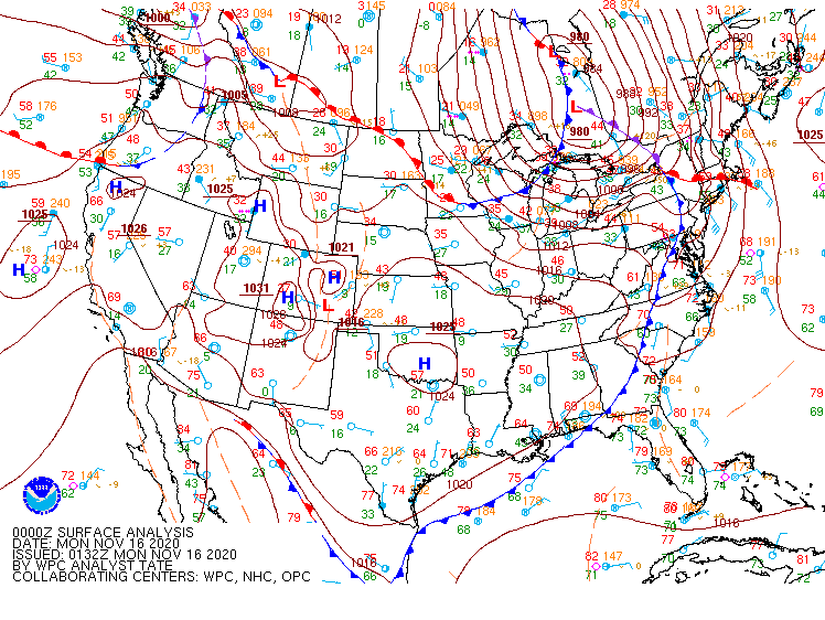
An amplified midlevel wave emerged over the central Plains on Saturday, November 14 and moved into the Great Lakes on Sunday, November 15. A 140 knot jet streak rounded the base of this wave by early Sunday, and the trough began to take on a negative tilt as it moved into the Great Lakes. This helped the system strengthen considerably as it tapped into a highly baroclinic environment across the region. The associated surface low pressure center tracked from the lower Missouri Valley northeast through Wisconsin and eventually across the eastern Upper Peninsula and Lake Superior. It deepened to a strong 980mb low as it reached Ontario Sunday afternoon.
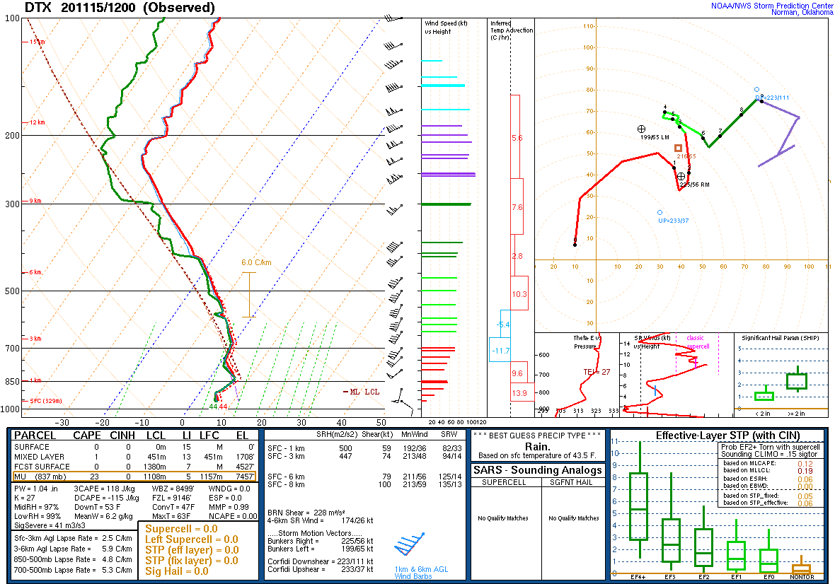
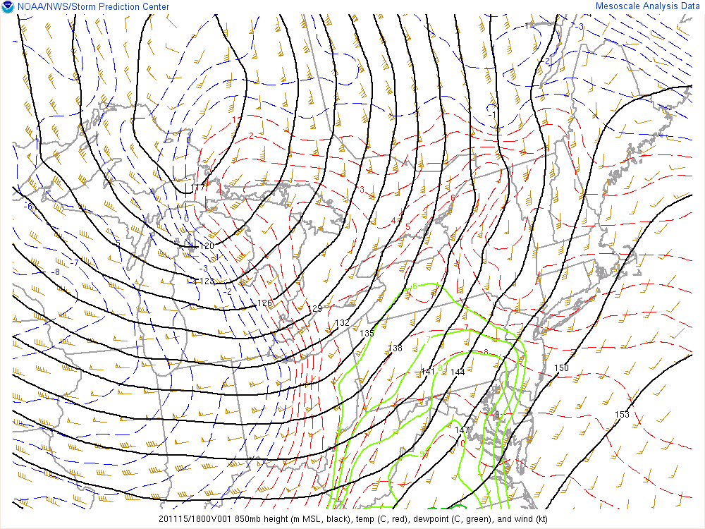
The warm front lifted through SE Michigan late Saturday into early Sunday with widespread showers and some thunderstorms across the region and temperatures rising from the upper 30s/lower 40s to mid 50s. A very strong low-level jet was positioned over the region during this time with 50 to 60 knot winds just a few thousand feet above the ground. A stable low-level profile kept most of this momentum from reaching the ground until Sunday morning when daytime heating allowed better mixing to begin. As the low moved into eastern Lake Superior midday Sunday, the system’s strong cold front swept across the state and temperatures quickly fell back to the 40s and 30s. The front was accompanied by a line of strong showers and a few storms. While winds were already ramping up in the warm sector ahead of this, the line of convection was able to tap into the strong wind aloft and bring gusts of 50+ mph to the surface.
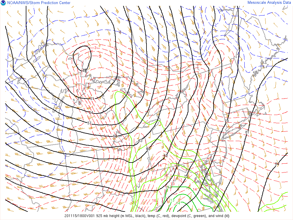
The cold front introduced strong cold advection that rapidly deepened the mixed layer heading into the afternoon. This promoted efficient mixing of the stronger winds aloft down to the surface. Wind gusts of 40 to 50 mph were common through the afternoon and evening with numerous gusts over 60 mph. The magnitude and longevity of the wind resulted in widespread tree and power line damage across the region. As the low occluded and continued tracking northeast into Ontario and Quebec, the pressure gradient and wind magnitude gradually weakened Sunday night.
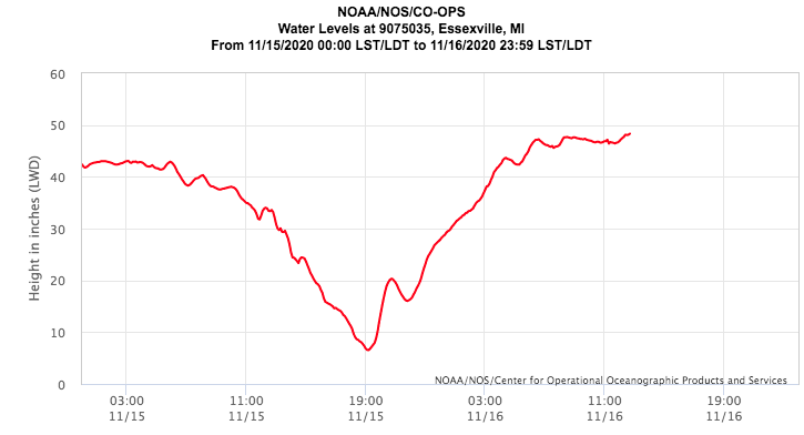
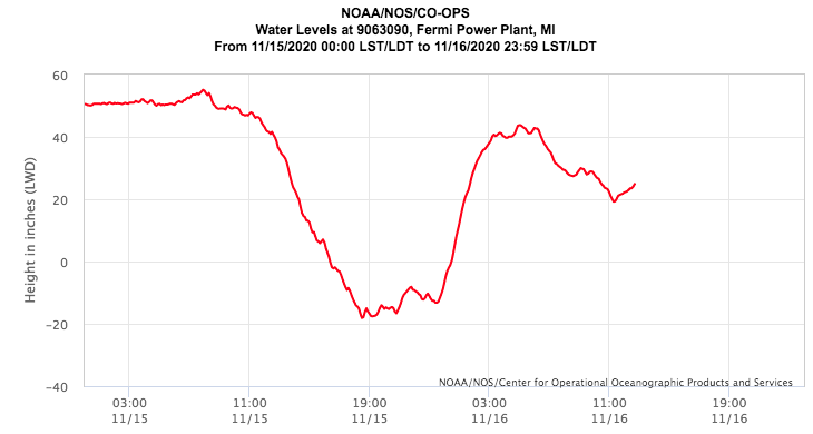
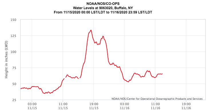
Another impact of the high wind was very low water levels across western Lake Erie and Saginaw Bay. Lake levels fell about 3 feet at Essexville (Saginaw Bay) from Sunday morning to Sunday evening. At Toledo and Fermi (western Lake Erie), lake levels fell about 7 feet and 5.5 feet respectively, even surpassing the low water datum for those sites. Meanwhile on the far side of Lake Erie in Buffalo, water levels jumped about 6 feet Sunday evening. When the winds weakened Sunday night, much of the displaced water rushed back to the western basin as part of a seiche.
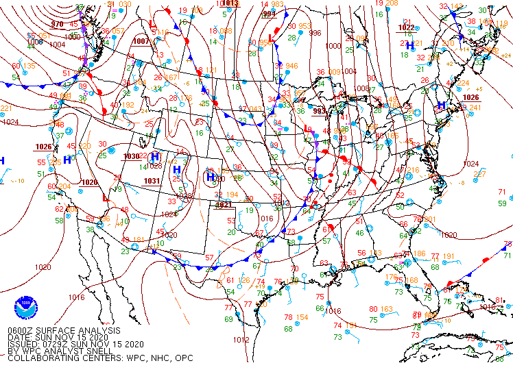
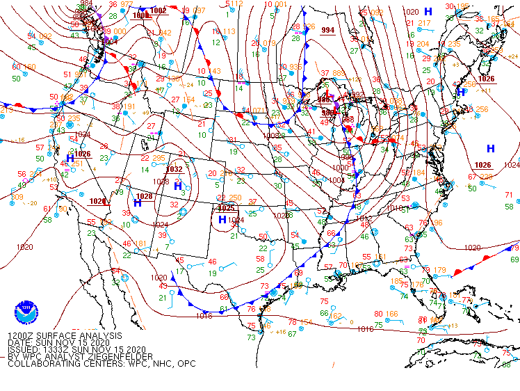
Click on the images below to see them expanded.
 |
 |
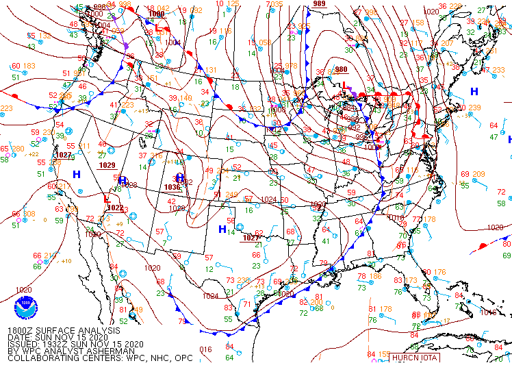 |
| Figure 1: Weather Prediction Center (WPC) surface map, valid 06 UTC 15 November 2020. | Figure 2: Weather Prediction Center (WPC) surface map, valid 12 UTC 15 November 2020. | Figure 3: Weather Prediction Center (WPC) surface map, valid 18 UTC 15 November 2020. |
 |
 |
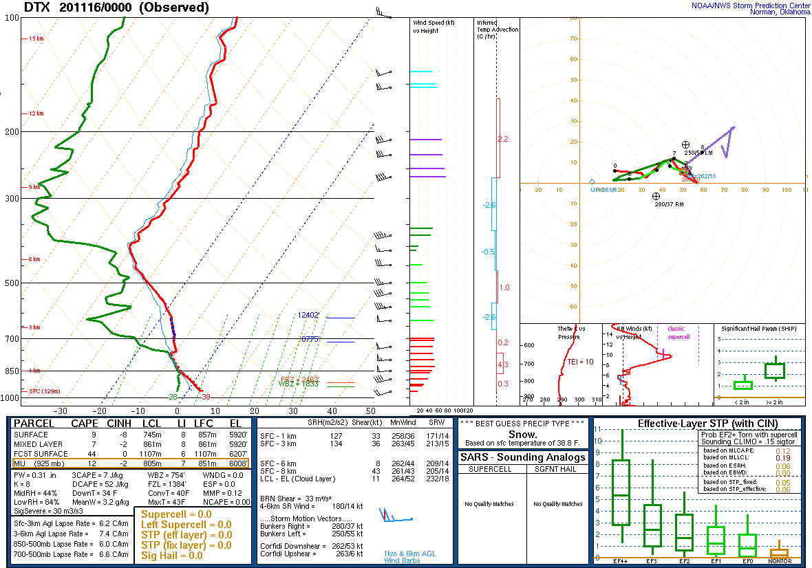 |
| Figure 4: Weather Prediction Center (WPC) surface map, valid 00 UTC 16 November 2020. | Figure 5: KDTX observed sounding, valid 12 UTC 15 November 2020. | Figure 6: KDTX observed sounding, valid 00 UTC 16 November 2020. |
 |
 |
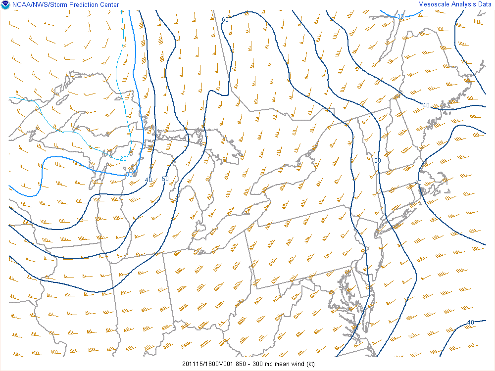 |
| Figure 7: SPC Mesoanalysis 925 hPa map, valid 18 UTC 15 November 2020. | Figure 8: SPC Mesoanalysis 850 hPa map, valid 18 UTC 15 November 2020. | Figure 9: SPC Mesoanalysis 850 - 300 hPa Mean Wind, valid 18 UTC 15 November 2020. |
 |
 |
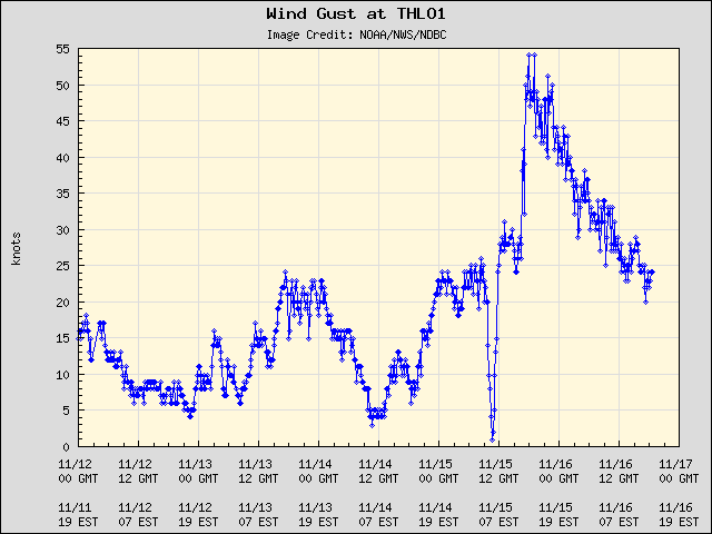 |
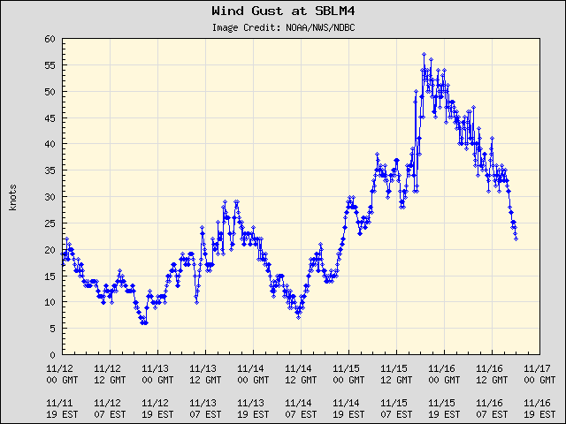
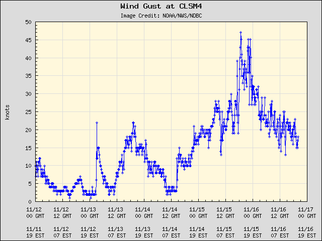
| Figure 10: Measured wind gust at Saginaw Bay Light - SBLM4. | Figure 11: Measured wind gust at St. Clair Shores - CLSM4. | Figure 12: Measured wind gust at Toledo Light - THLO1. |
 |
 |
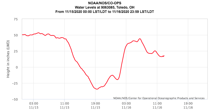 |
| Figure 13: Measured water level at Essexville, MI. | Figure 14: Measured water level at Fermi in Newport, MI | Figure 15: Measured water level at Toledo, OH. |
 |
||
| Figure 16: Measured water level at Buffalo, NY. |
 |
Media use of NWS Web News Stories is encouraged! Please acknowledge the NWS as the source of any news information accessed from this site. |
|