Overview
Line of showers and thunderstorms rapidly developed from northern Ohio to northern lower Michigan early in the afternoon of the 5th in advance of an approaching cold front. Scattered storms within this line became strong to severe as they crossed SE MI leading to areas of wind damage over the northern Metro Detroit area as well as into the eastern Thumb. While this occurred, a spin-up tornado occurred over Livonia resulting in tree damage/downed trees along its path with one large tree falling on a home unfortunately killing a 2 year old boy and critically injuring his mother as they slept.
Tornado:
|
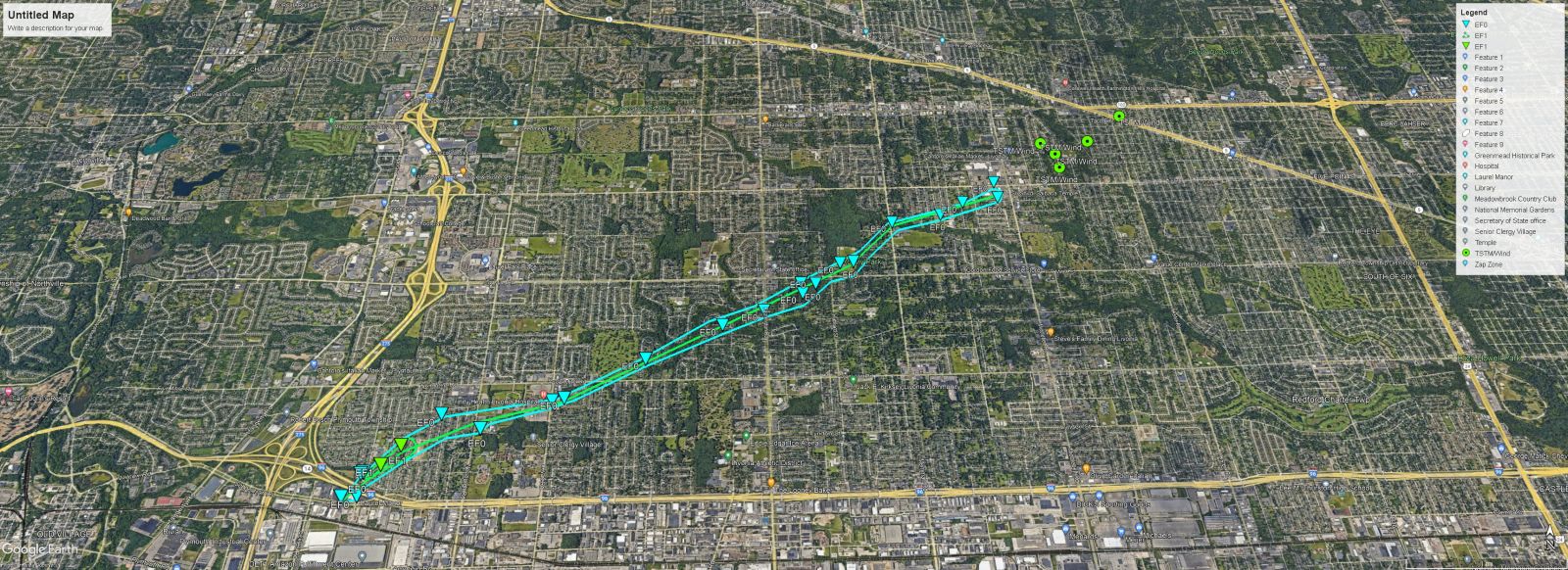
Tornado - Livonia, MI
Track Map

|
||||||||||||||||
The Enhanced Fujita (EF) Scale classifies tornadoes into the following categories:
| EF0 Weak 65-85 mph |
EF1 Moderate 86-110 mph |
EF2 Significant 111-135 mph |
EF3 Severe 136-165 mph |
EF4 Extreme 166-200 mph |
EF5 Catastrophic 200+ mph |
 |
|||||
Radar
Radar Imagery for SE MI
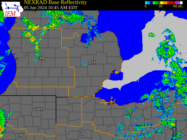
Radar loop courtesy of Iowa Environmental Mesonet (IEM)
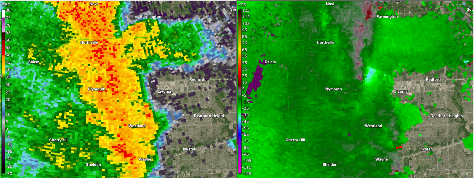
Figure 1. DTX base reflectivity and velocity at 336 PM on 05 June 2024, centered on Livonia, MI.
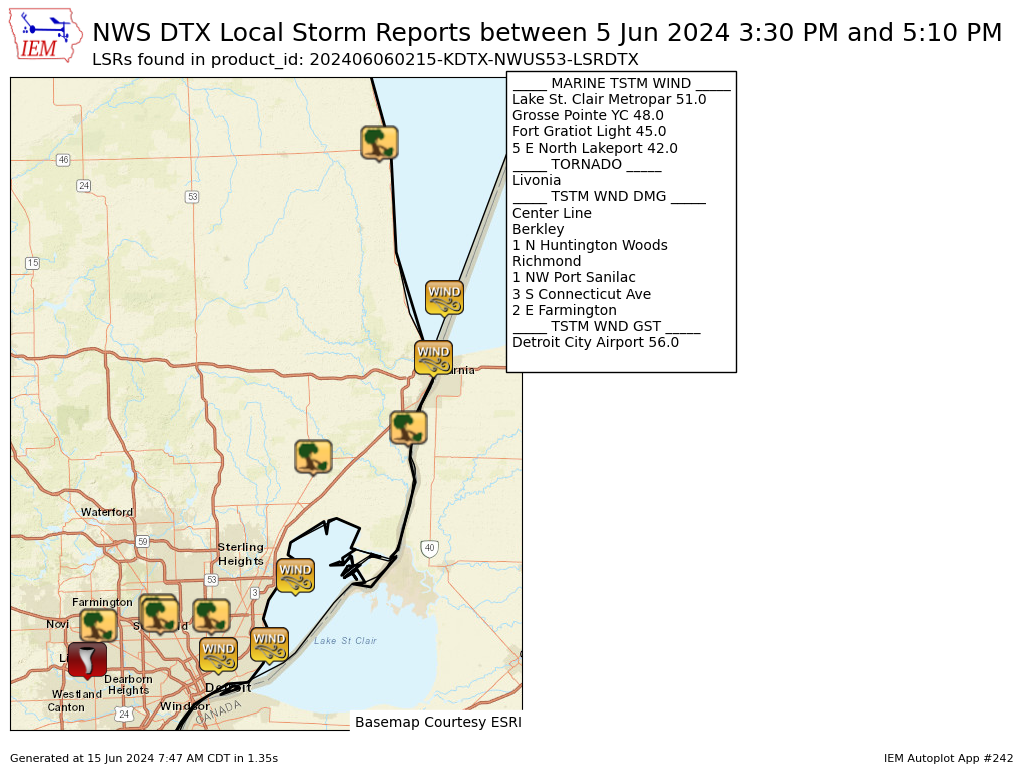
Storm Reports
|
|
|
Map of Local Storm Reports for June 05, 2024 |
Preliminary Local Storm Report...Summary
National Weather Service Detroit/Pontiac MI
1015 PM EDT Wed Jun 05 2024

..TIME...   ...EVENT...      ...CITY LOCATION...     ...LAT.LON...
..DATE...   ....MAG....      ..COUNTY LOCATION..ST.. ...SOURCE....
            ..REMARKS..

0330 PM     Tornado          Livonia                 42.40N  83.37W
06/05/2024                   Wayne              MI   Emergency Mngr

            The Livonia Emergency Manager reported extensive tree
            damage extending from Lyndon to Norman St to Six Mile
            and Merriman Rd.

0339 PM     Tstm Wnd Dmg     2 E Farmington          42.47N  83.34W
06/05/2024                   Oakland            MI   Broadcast Media

            Multiple pictures posted on social media of gas station
            awning collapsed onto cars.

0353 PM     Tstm Wnd Dmg     1 N Huntington Woods    42.49N  83.17W
06/05/2024                   Oakland            MI   Trained Spotter

            Estimated 10 inch tree limb snapped.

0353 PM     Tstm Wnd Dmg     Berkley                 42.50N  83.18W
06/05/2024                   Oakland            MI   Public

            Estimated 5 inch tree limb snapped.

0400 PM     Tstm Wnd Dmg     Center Line             42.49N  83.03W
06/05/2024                   Macomb             MI   Public

            One foot diameter tree limb downed.

0401 PM     Tstm Wnd Gst     Detroit City Airport    42.41N  83.01W
06/05/2024  M56 mph          Wayne              MI   ASOS

            Measured at KDET Detroit City Airport ASOS

0410 PM     Marine Tstm Wind Grosse Pointe YC        42.43N  82.87W
06/05/2024  M48 mph          Wayne              MI   Mesonet

            Measured at Grosse Pointe Yacht Club.

0419 PM     Marine Tstm Wind Lake St. Clair Metropar 42.57N  82.80W
06/05/2024  M51 mph          Macomb             MI   Mesonet

            Measured at Lake St. Clair Metropark.

0427 PM     Tstm Wnd Dmg     Richmond                42.81N  82.75W
06/05/2024                   Macomb             MI   Trained Spotter

            Estimated 8 inch tree limb downed.

0433 PM     Tstm Wnd Dmg     1 NW Port Sanilac       43.44N  82.57W
06/05/2024                   Sanilac            MI   911 Call Center

            Report of multiple trees down across Carsonville.

0447 PM     Tstm Wnd Dmg     3 S Connecticut Ave     42.87N  82.49W
06/05/2024                   St. Clair          MI   911 Call Center

            911 dispatch reports multiple trees and power lines
            down across the county.

0500 PM     Marine Tstm Wind Fort Gratiot Light      43.01N  82.42W
06/05/2024  M45 mph          LHZ443             MI   C-Man Station

            Measured at Fort Gratiot Light - FTGM4.

0510 PM     Marine Tstm Wind 5 E North Lakeport      43.13N  82.39W
06/05/2024  M42 mph          LHZ443             MI   Buoy

            Measured at buoy 45209.
|
|
|
 |
Media use of NWS Web News Stories is encouraged! Please acknowledge the NWS as the source of any news information accessed from this site. |
|