Overview
A robust upper trough approached the western Great Lakes on September 25, while low pressure developed over northern Lower Michigan along a cold front draped over the region. Ahead of this cold front, southwest winds brought warm and moist air (dew points exceeding 70 degrees in a few areas) to Southeast Michigan during the daytime and evening hours. This air mass paired with ample wind shear (bulk wind shear of greater than 40 kt and low level helicity exceeding 100 m²/s²) was sufficient for a couple rounds of thunderstorms to move through the area. One round of storms developed over West Michigan in the afternoon and moved northeast into the Tri-Cities area by early evening. No damage was reported from these storms, but almost 2 inches of rain fell around Midland.
Another round of storms formed near the Michigan/Ohio border in the evening and moved through our southeastern counties. These storms strengthened quickly and produced three tornadoes over northern Monroe and southern Wayne Counties in addition to heavy rainfall. Additional information on the tornadoes can be found under the Tornado Summary tab.
Tornado Summary
|
|
||||||||||
|
||||||||||
|
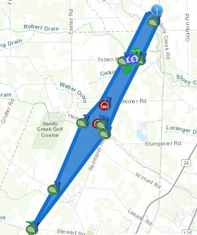
Tornado #1 - Frenchtown Township
|
Track Map
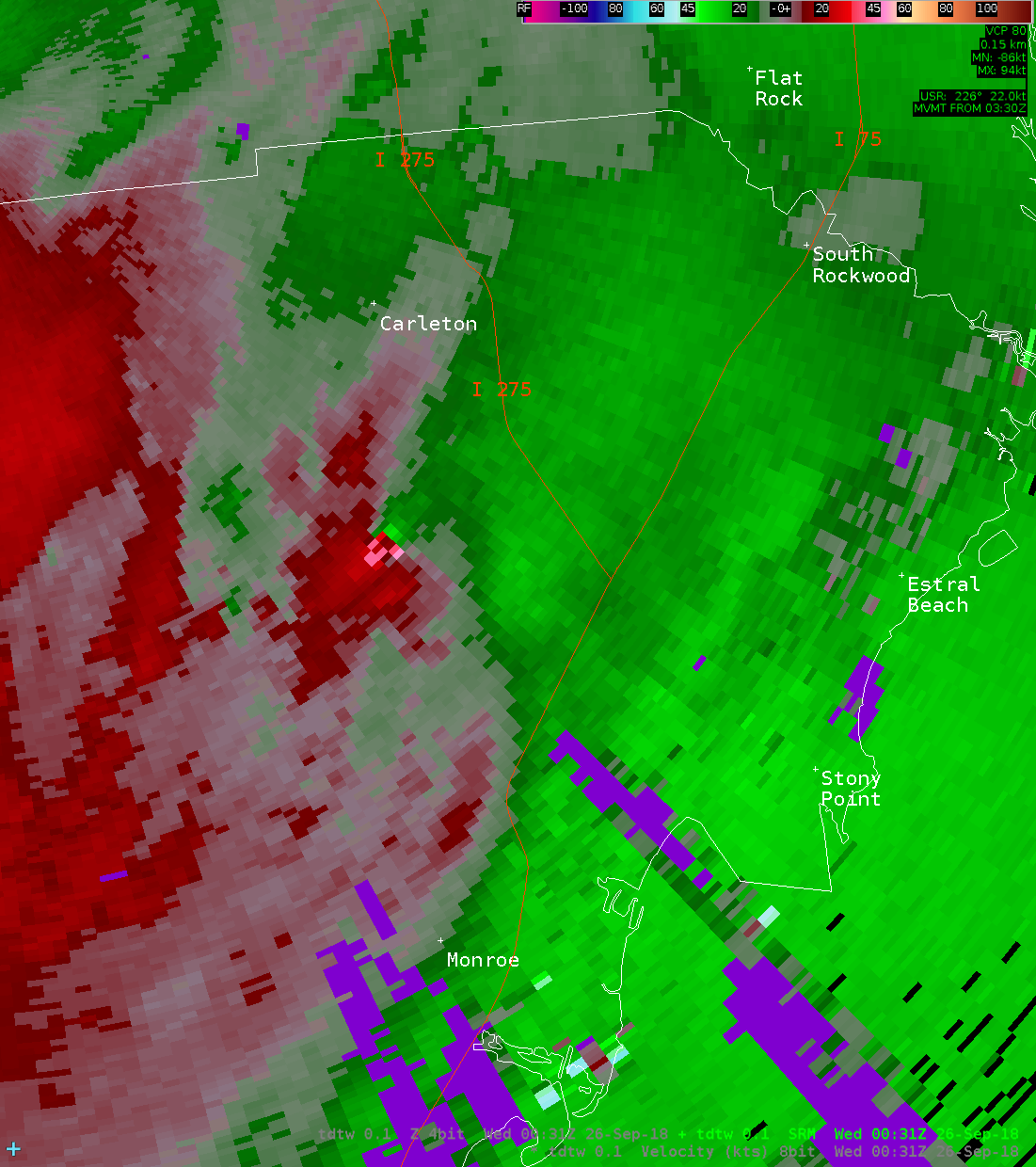
Radar Velocity Image at 8:31 PM Inbound velocities (green) located next to outbound velocities (red)
|
||||||||||||||||
|
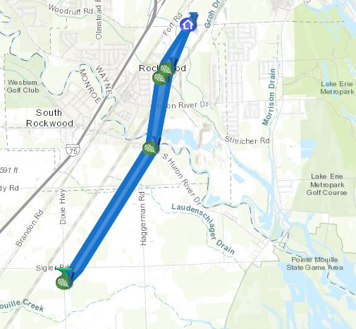
Tornado #2 - South Rockwood/Rockwood
|
Track Map
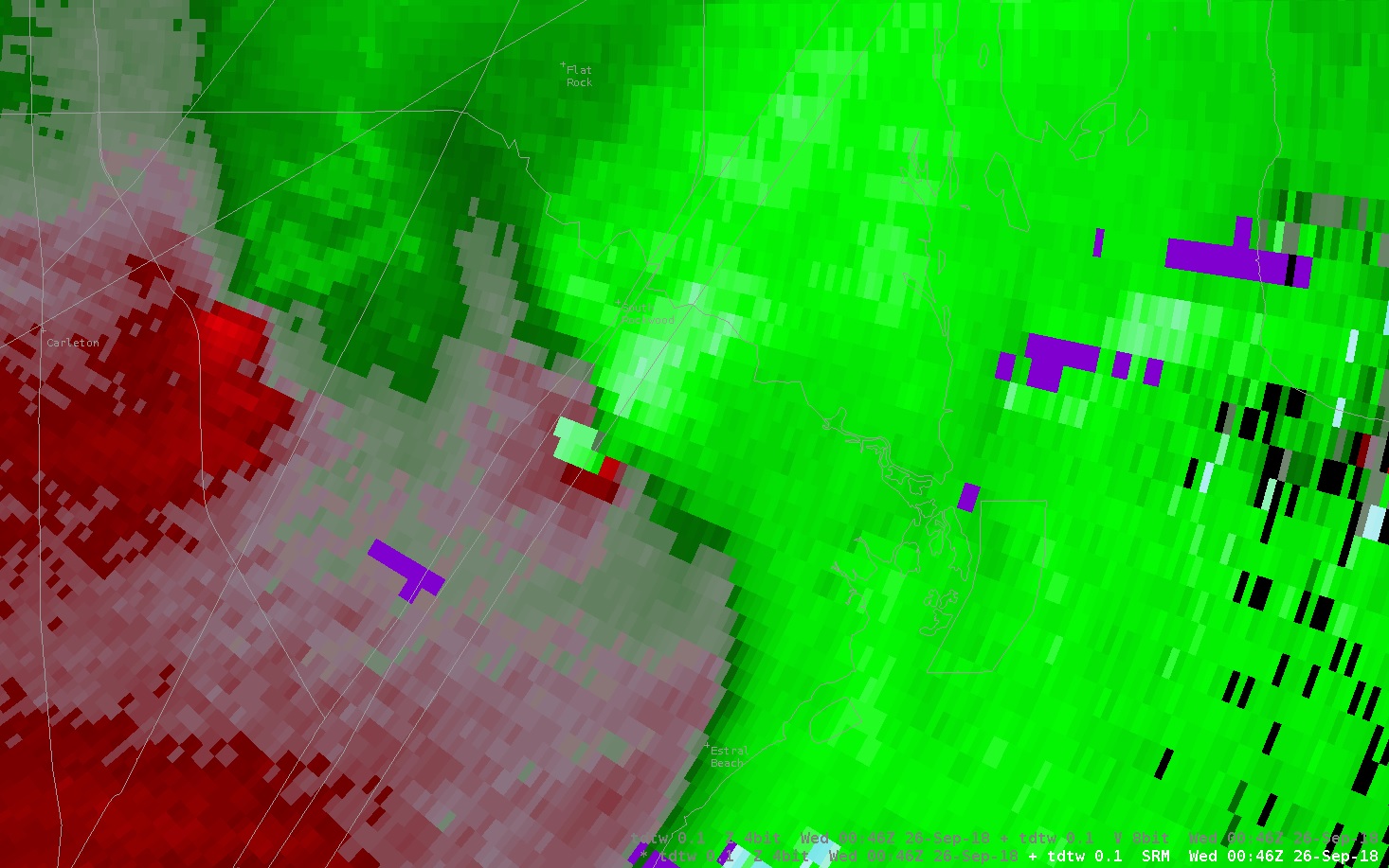
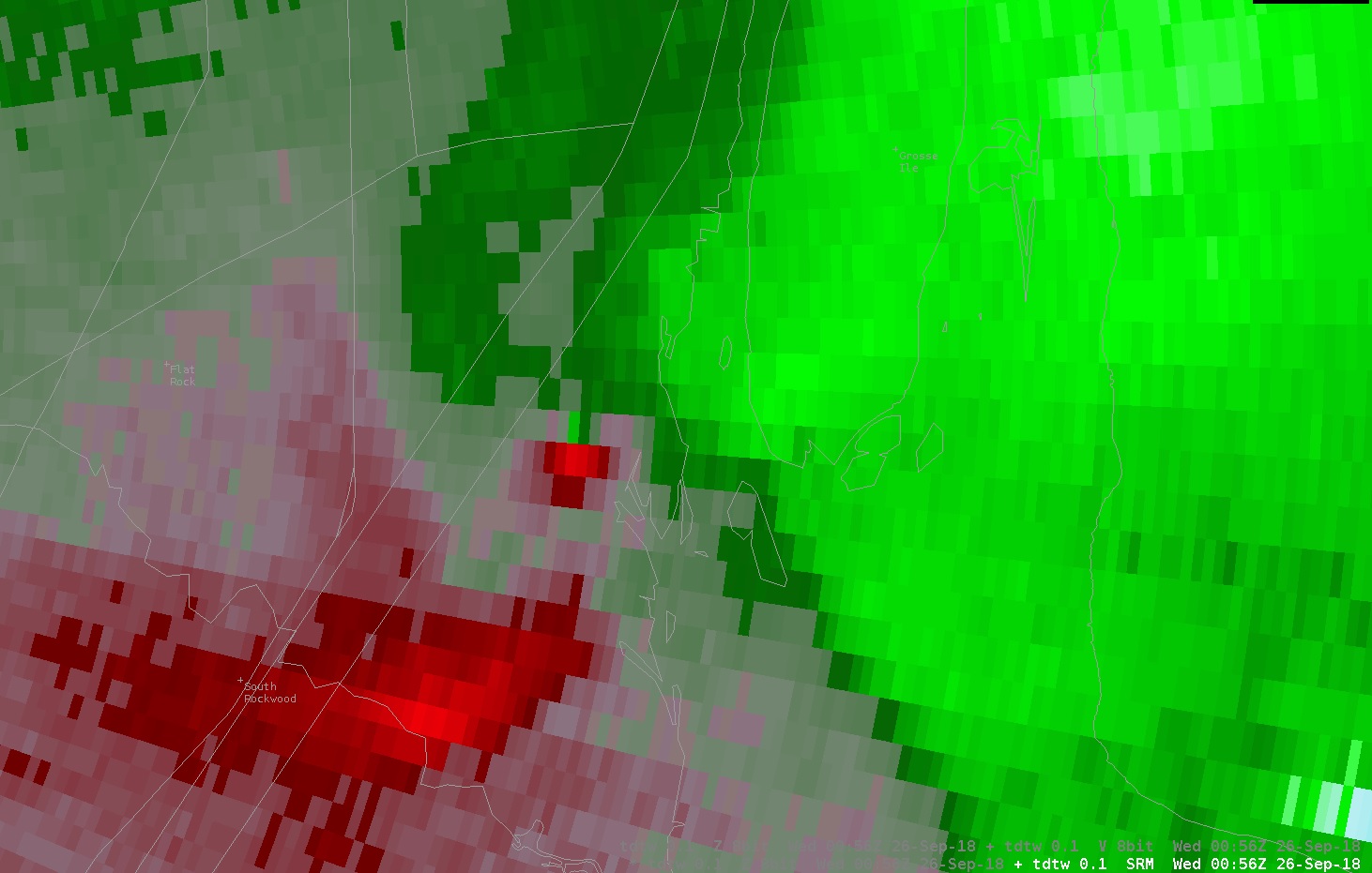
Radar Velocity Image at 8:46 PM Inbound velocities (green) located next to outbound velocities (red)
|
||||||||||||||||
|
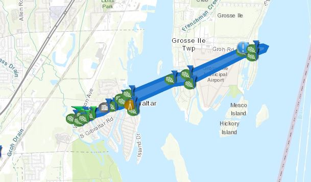
Tornado #3 - Gibraltar
|
Track Map
Radar Velocity Image at 8:56 PM Inbound velocities (green) located next to outbound velocities (red)
|
||||||||||||||||
The Enhanced Fujita (EF) Scale classifies tornadoes into the following categories:
| EF0 Weak 65-85 mph |
EF1 Moderate 86-110 mph |
EF2 Significant 111-135 mph |
EF3 Severe 136-165 mph |
EF4 Extreme 166-200 mph |
EF5 Catastrophic 200+ mph |
 |
|||||
Tornado Public Information Statement
Public Information Statement
National Weather Service Detroit/Pontiac MI
459 PM EDT Wed Sep 26 2018

...NWS DAMAGE SURVEY FOR THE 09/25/2018 TORNADO EVENT...

...TORNADO CONFIRMED AND RATED EF1 IN FRENCHTOWN TOWNSHIP IN
MONROE COUNTY MICHIGAN...

.Frenchtown Township tornado...

Update...No new changes to this tornado event.

Rating:                 EF-1
Estimated peak wind:    95-100 mph
Path length /Statute/:  4.3 miles
Path width /Maximum/:   520 yards
Fatalities:             0
Injuries:               0

Start date:             SEP 25 2018
Start time:             823 PM EDT
Start location:         41.9562 / -83.4321

End date:               SEP 25 2018
End time:               832 PM EDT
End location:           42.0099 / -83.3892

SURVEY SUMMARY: The path began as weak EF0 damage, mainly to
trees, until near Reinhardt and Heiss roads where it became a solid
EF0. The tornado reached EF1 strength near Toben and South Stony
Creek roads where roofing material was removed leaving exposed
trusses and windows that were blown out of homes in the area.
Garage doors were also blown in and many trees were damaged and
uprooted. EF0 damage to siding and tree limbs was noted before the
tornado dissipated near North Stoney Creek road and the railroad
tracks.


...SECOND TORNADO CONFIRMED AND RATED EF0 IN NORTHERN MONROE AND
SOUTHERN WAYNE COUNTIES...

.South Rockwood/Rockwood tornado...

Update...Name change for second tornado from previous PNS

Rating:                 EF-0
Estimated peak wind:    60-65 mph
Path length /Statute/:  3.8 miles
Path width /Maximum/:   200 yards
Fatalities:             0
Injuries:               0

Start date:             SEP 25 2018
Start time:             845 PM EDT
Start location:         42.0356 / -83.264

End date:               SEP 25 2018
End time:               852 PM EDT
End location:           42.0870 / -83.225

SURVEY SUMMARY: An EF0 tornado began in Berlin Township in Monroe
County just south of Sigler Road on North Dixie Highway. The tornado
remained at EF0 strength throughout the entire path length, before
dissipating near the intersection of Meadow Lane and Ostreich Road in
Wayne County near the border of Brownstown Charter Township and the city
of Gibraltar. Damage included multiple limbs and large trees downed,
along with missing shingles to a house near the end of the tornado path.


...THIRD TORNADO CONFIRMED AND RATED EF1 IN WAYNE COUNTY MICHIGAN...

.Gibraltar tornado...

Update...This is new information regarding this tornado event.

Rating:                 EF-1
Estimated peak wind:    95-100 mph
Path length /Statute/:  3.5 miles
Path width /Maximum/:   250 yards
Fatalities:             0
Injuries:               0

Start date:             SEP 25 2018
Start time:             855 PM EDT
Start location:         42.0914 / -83.2059

End date:               SEP 25 2018
End time:               902 PM EDT
End location:           42.1079 / -83.1462

SURVEY SUMMARY: An EF1 tornado began just to the west of W Jefferson
Ave and south of Gibraltar Road.  The tornado remained at EF1 strength
up to the Navarre Street and Young Drive area, before weakening to EF0
strength for the remainder of the path.  The tornado then crossed the
Detroit River before dissipating at the north end of Elba Island in
Grosse Ile Township.  Damage included multiple large limbs and trees
downed, a roof partially blown off and powerlines downed.

EF Scale: The Enhanced Fujita Scale Classifies
Tornadoes into the following categories.

EF0...Weak......65 to 85 mph
EF1...Weak......86 to 110 mph
EF2...Strong....111 to 135 mph
EF3...Strong....136 to 165 mph
EF4...Violent...166 To 200 mph
EF5...Violent...>200 mph

NOTE:
The information in this statement is PRELIMINARY and subject to
change pending final review of the events and publication in
NWS Storm Data.
Photos & Video:
 |
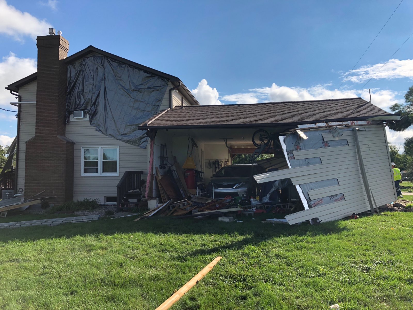 |
| Frenchtown Tornado Damage Photo Credit: NWS Storm Survey Team |
Frenchtown Tornado Damage Photo Credit: NWS Storm Survey Team |
Radar:
 |
|
Click to enlarge the radar loop Radar loop courtesy of Iowa Environmental Mesonet (IEM) |
Heavy Rain Reports
Public Information Statement...Storm Totals
National Weather Service Detroit/Pontiac MI
1231 PM EDT Wed Sep 26 2018


STORM TOTAL HEAVY RAIN REPORTS

Location                   Precip      Duration
                          (Inches)      (Hours)        Lat       Lon

...Lenawee County...
   Adrian                  M  1.23           24     41.90N    84.04W
   Nnw Tecumseh            M  1.27           24     42.01N    83.94W
   Morenci                 M  1.86           24     41.72N    84.22W

...Macomb County...
   1 ENE Roseville         M  2.37           24     42.51N    82.92W
   Warren                  M  2.42           24     42.49N    83.03W

...Midland County...
   Midland                 M  1.76            1     43.62N    84.23W

...Monroe County...
   Dundee                  M  1.94           24     41.96N    83.66W

...Washtenaw County...
   Manchester              M  1.02           24     42.15N    84.04W
   1 SSE Saline            M  1.10           24     42.16N    83.77W
   Milan                   M  1.12           24     42.09N    83.68W
   2 E Ypsilanti           M  2.29           13     42.24N    83.58W

...Wayne County...
   6 ENE Detroit           M  1.65           24     42.41N    83.01W
   1 N Grosse Ile          M  2.16           24     42.14N    83.15W
   Dearborn                M  2.44           24     42.31N    83.21W
   1 SE Romulus            M  2.46           24     42.22N    83.36W
   Southgate               M  2.48            6     42.20N    83.21W
   Wyandotte               M  2.48            1     42.21N    83.16W
   Garden City             M  2.55           13     42.33N    83.33W
   Grosse Pointe Farms     M  2.67           24     42.40N    82.89W
   2 NNW Flat Rock         M  2.68           24     42.13N    83.29W


M = Measured
E = Estimated
Observations are collected from a variety of sources with varying equipment and exposures. All data is preliminary and has not undergone final quality control by the National Climatic Data Center / NCDC/. Therefore...this data may be subject to revision. We thank all volunteer weather observers for their dedication. Not all data listed are considered official. Final and certified climate data can be accessed at www.ncdc.noaa.gov
 |
Media use of NWS Web News Stories is encouraged! Please acknowledge the NWS as the source of any news information accessed from this site. |
|