Overview
An active severe weather season for Southeast Michigan continued on July 24, 2021 with another round of severe thunderstorms and tornadoes. Thunderstorms initially developed mid-afternoon just south of Cadillac and tracked southeastward into the Tri-Cities and Metro Detroit regions through the evening. Storms began as a broken line and strengthened quickly as they moved into a region of favorable dynamics and ample instability. Embedded rotation within this line produced three confirmed tornadoes in White Lake, Armada, and Clayton Township. Numerous reports of straight-line wind damage, namely power outages and tree damage, were also observed with many of these reports coming from western Oakland County. As the line of storms tracked south of I-94, the tornado threat diminished; although bowing segments embedded within the line continued to produce damaging wind gusts. In addition to wind damage, most areas observed 1-2 inches (with locally higher amounts) of rainfall which led to flash flooding in some low-lying and flood-prone areas.
Tornado Information
|
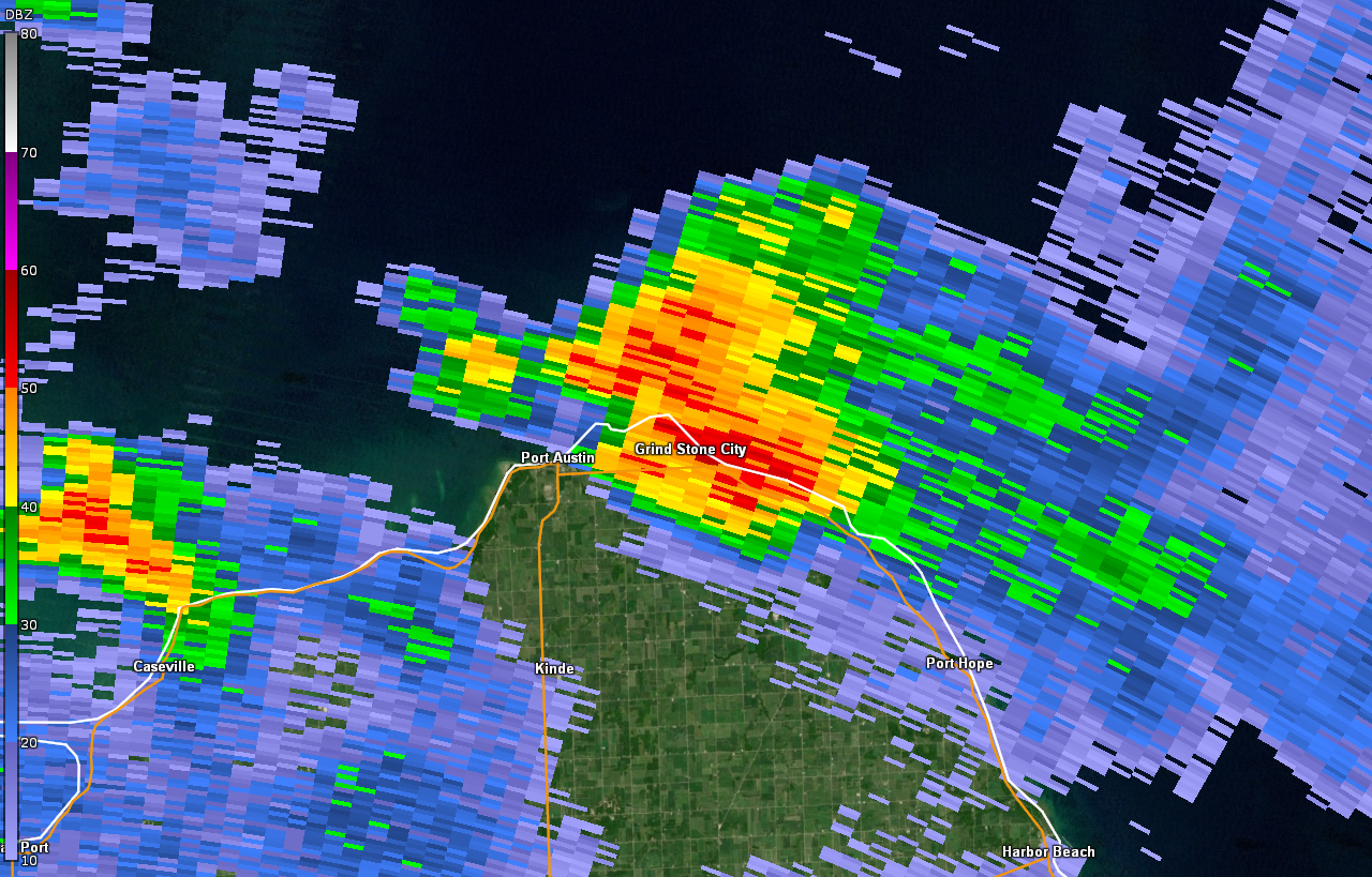
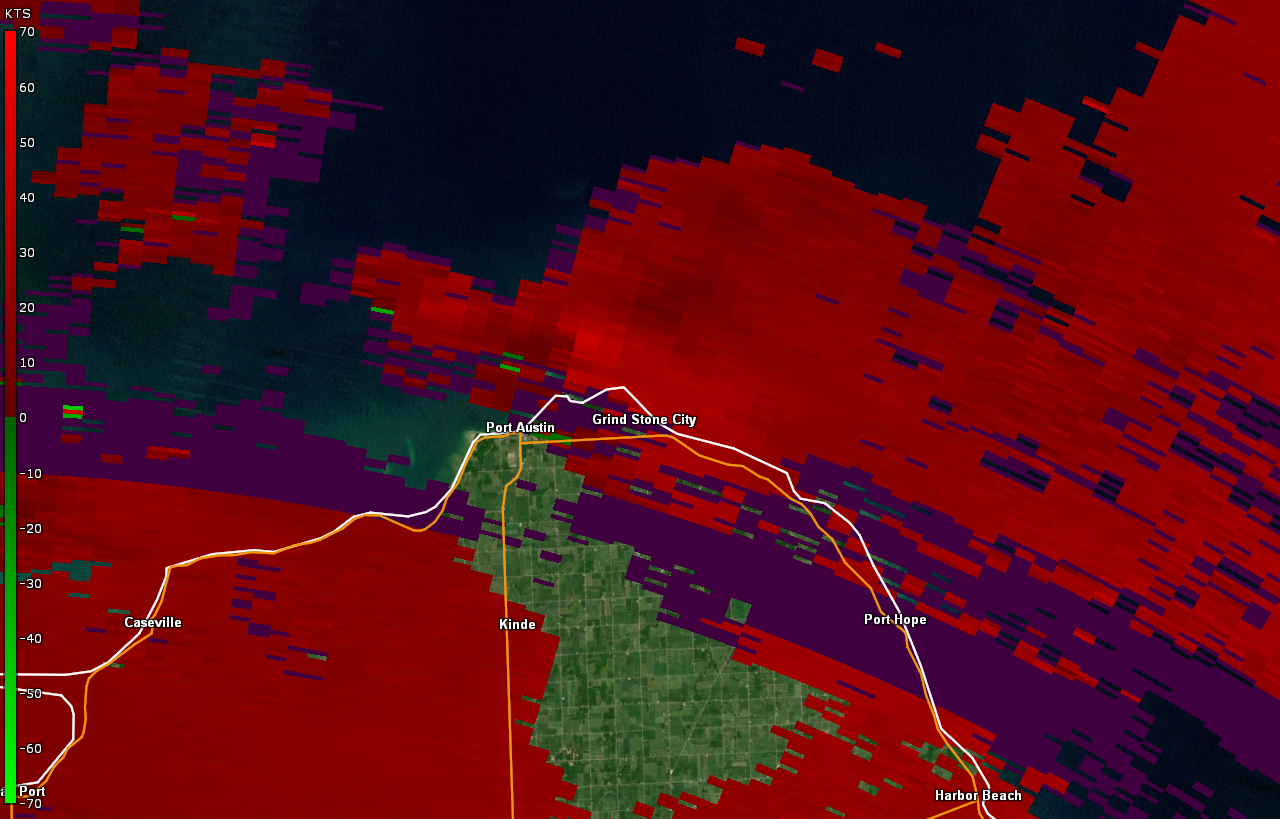
Tornado 1 - Port Austin, MI
Track Map
*Tornado track map in progress*

Radar Velocity Image at 4:36 PM EDT Inbound velocities (green) located next to outbound velocities (red) |
||||||||||||||||
|
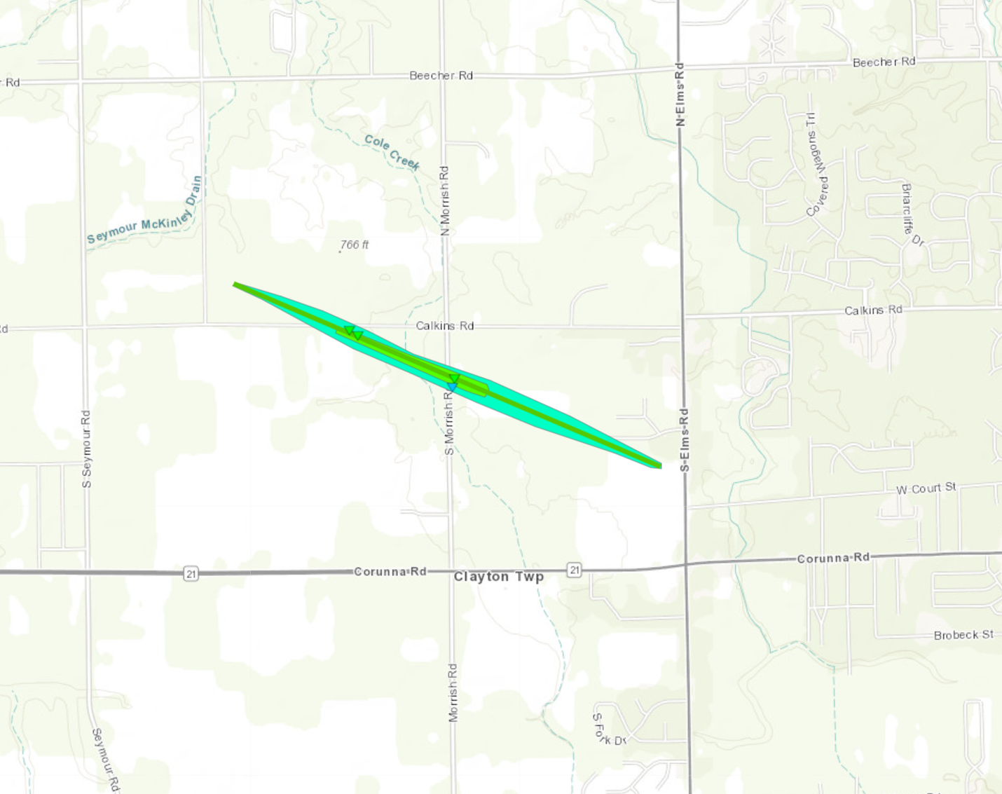
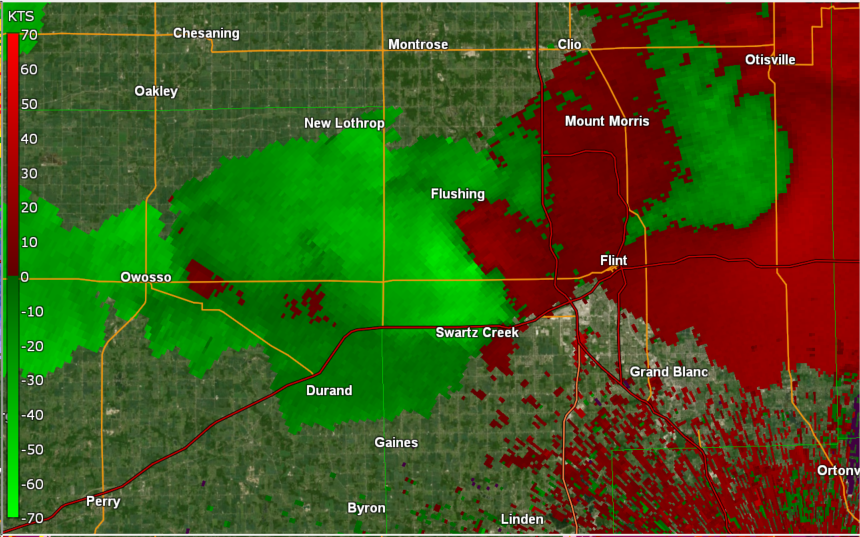
Tornado 2 - Clayton Township, MI
Track Map
Radar Velocity Image at 7:55 PM EDT Inbound velocities (green) located next to outbound velocities (red)
|
||||||||||||||||
|
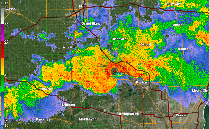
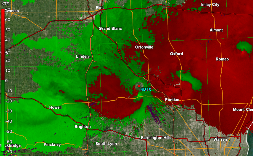
Tornado 3 - White Lake Township, MI
Track Map
Radar Velocity Image at 7:55 PM EDT Inbound velocities (green) located next to outbound velocities (red)
|
||||||||||||||||
|
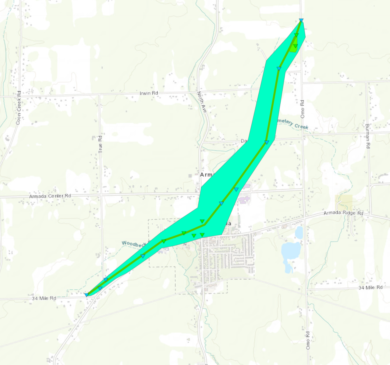
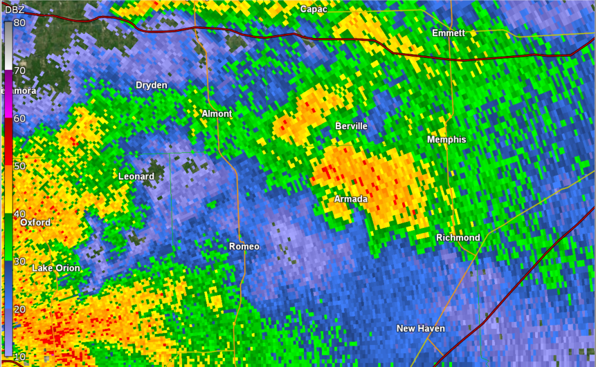
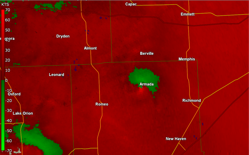
Tornado 4 - Armada, MI
Track Map
Radar Velocity Image at 7:55 PM EDT Inbound velocities (green) located next to outbound velocities (red)
|
||||||||||||||||
The Enhanced Fujita (EF) Scale classifies tornadoes into the following categories:
| EF0 Weak 65-85 mph |
EF1 Moderate 86-110 mph |
EF2 Significant 111-135 mph |
EF3 Severe 136-165 mph |
EF4 Extreme 166-200 mph |
EF5 Catastrophic 200+ mph |
 |
|||||
Photos & Local Media Coverage
 |
 |
 |
|
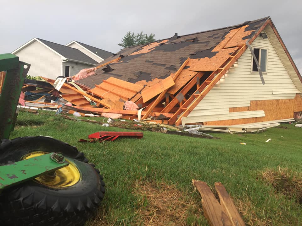
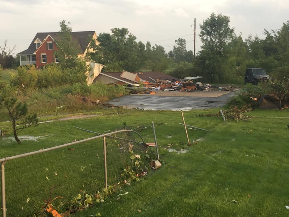
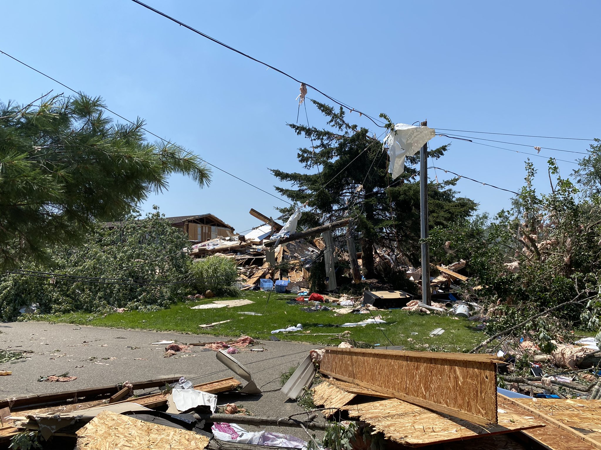
Tornado Damage in Armada Credit: Matheu Morrison |
Tornado Damage in Armada Credit: Matheu Morrison |
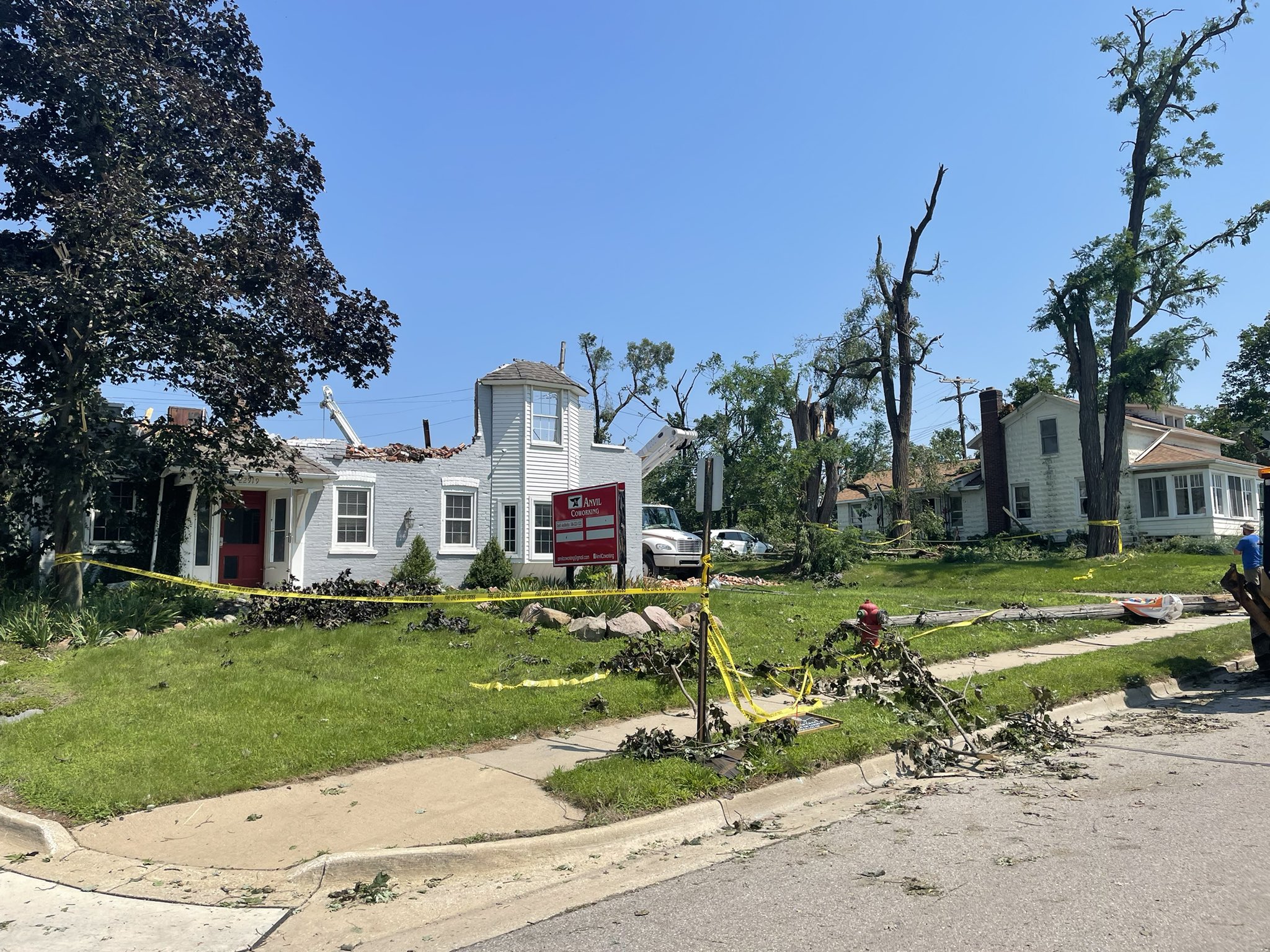
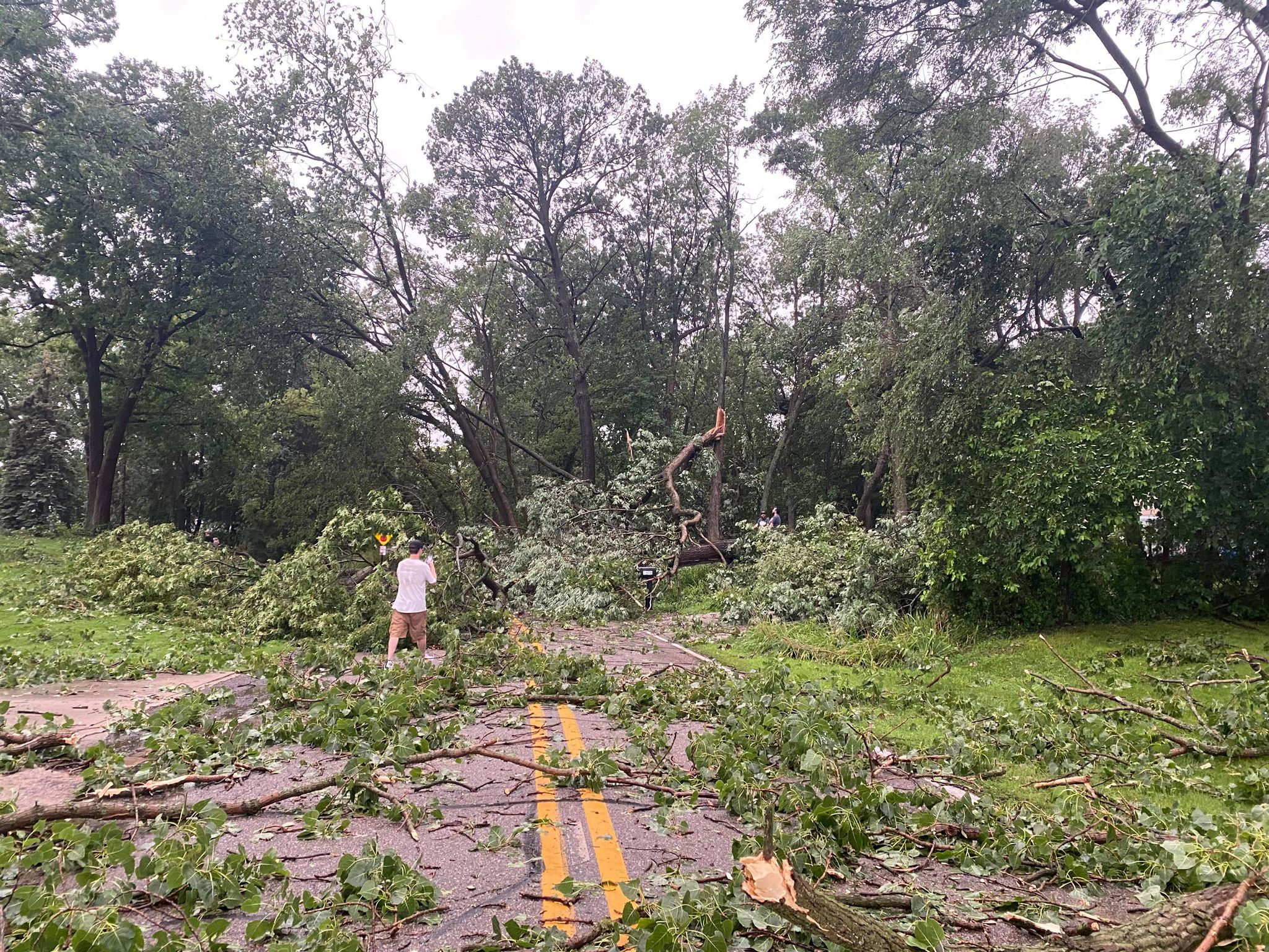
Tornado Damage in Clayton Twp Credit: Ron Hilliard (NBC 25/FOX 66) |
 |
 |
 |
|
Tornado Damage in Clayton Twp Credit: Ron Hilliard (NBC 25/FOX 66) |
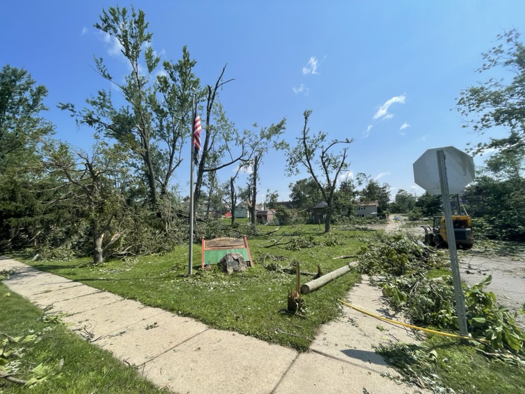
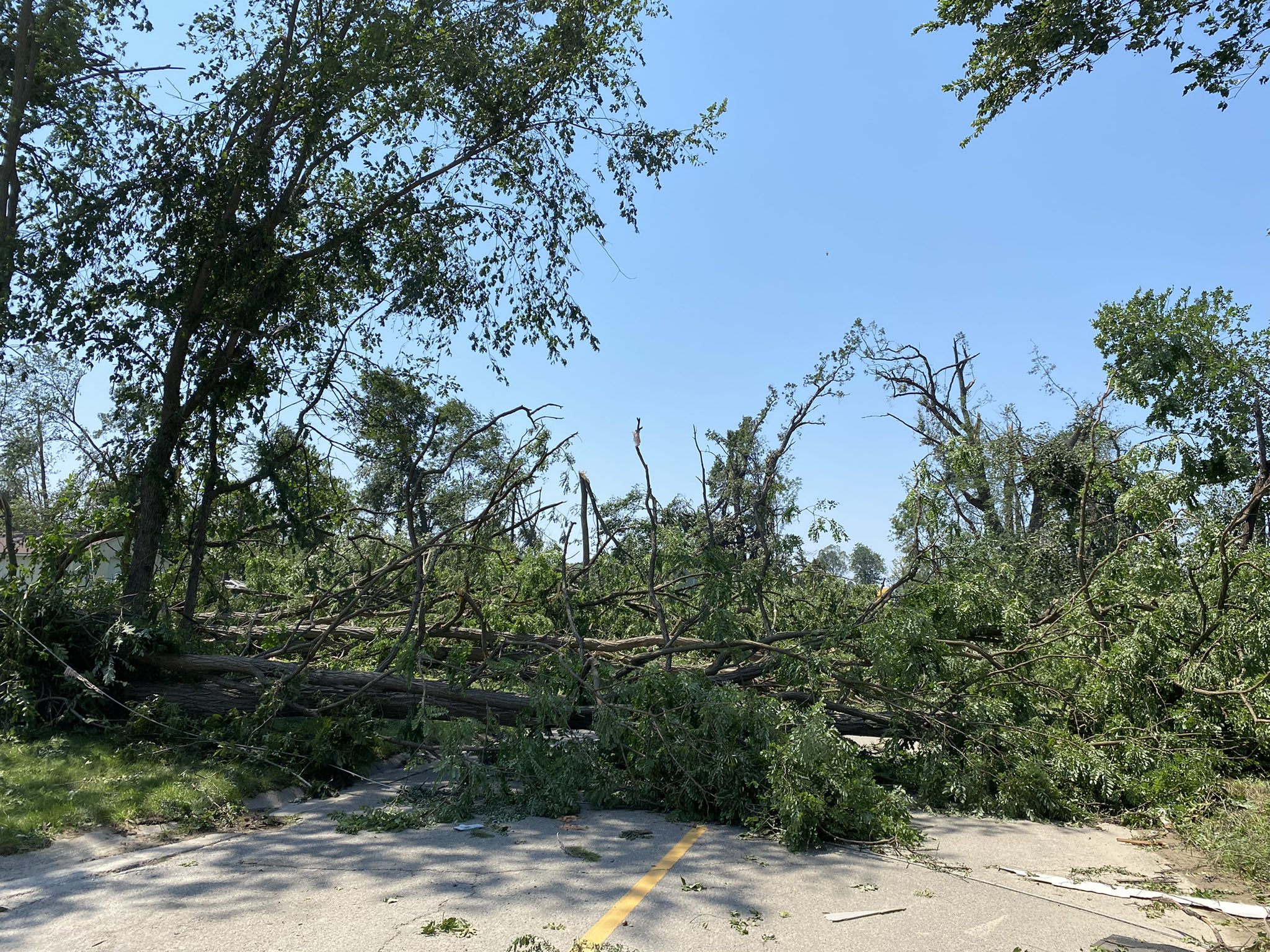
Tornado Damage in White Lake Credit: Nick Dewhirst |
Tornado Damage in White Lake Credit: Nick Dewhirst |
 |
 |
 |
|
Wind Damage in Madison Heights Credit: Robyn Anderson |
Wind Damage in Walled Lake Credit: Cody Reynolds |
Wind Damage in Waterford Credit: Scott Craig |
**Additional photos to be added
Radar
|
Radar Image Courtesy of Iowa Environmental Mesonet
|
Storm Reports
Public Information Statement...Storm Totals
National Weather Service Detroit/Pontiac MI
222 PM EDT Sun Jul 25 2021


STORM TOTAL HEAVY RAIN REPORTS

Location                   Precip      Duration
                          (Inches)      (Hours)        Lat       Lon

...Bay County...
   3 E Kawkawlin           M  1.64           24     43.65N    83.90W

...Genesee County...
   4 N Burton              M  1.24           24     43.05N    83.62W
   1 N Swartz Creek        M  1.85           24     42.98N    83.83W
   5 SW Flint              M  2.24           24     42.97N    83.75W
   3 SE Grand Blanc        M  2.41           24     42.89N    83.59W

...Lapeer County...
   6 ENE Columbiaville     M  1.30           24     43.18N    83.30W
   1 W Lapeer              M  2.07           24     43.05N    83.35W

...Lenawee County...
   1 WNW Blissfield        M  1.27           24     41.84N    83.88W
   3 SW Adrian             M  1.30           24     41.87N    84.08W
   Morenci                 M  1.78           24     41.72N    84.22W

...Livingston County...
   2 S Argentine           M  1.35           24     42.77N    83.83W

...Macomb County...
   1 NW Grosse Pointe Shor M  1.26           24     42.46N    82.89W
   1 NW Grosse Pointe Shor M  1.26           24     42.46N    82.89W
   3 NW Mount Clemens      M  1.45           24     42.62N    82.92W
   2 N Saint Clair Shores  M  1.50           24     42.53N    82.88W
   3 N Utica               M  1.58           24     42.67N    83.03W
   2 SSE Utica             M  1.71           24     42.61N    83.01W
   1 N Fraser              M  2.13           24     42.56N    82.95W
   4 NNW Richmond          M  2.81           24     42.86N    82.78W

...Midland County...
   1 SE Midland            M  1.35           24     43.62N    84.22W
   Midland                 M  1.35           24     43.62N    84.23W
   4 W Midland             M  1.73           24     43.63N    84.32W
   Midland                 M  1.81           36     43.62N    84.23W

...Monroe County...
   3 S Monroe              M  1.18           24     41.87N    83.38W
   2 NW Monroe             M  1.94           24     41.93N    83.42W
   2 W Stony Point         M  3.04           24     41.94N    83.32W

...Oakland County...
   1 NW Ferndale           M  1.43           24     42.47N    83.15W
   5 NNW Novi              M  1.59           24     42.54N    83.52W
   4 E White Lake          M  1.75           24     42.65N    83.43W
   Farmington              M  1.83           24     42.46N    83.38W
   2 S Ortonville          M  1.88           24     42.82N    83.44W
   2 NNE Birmingham        M  2.06           24     42.57N    83.20W
   1 WSW Orchard Lake      M  2.43           24     42.58N    83.39W
   Bloomfield Hills        M  2.44           24     42.58N    83.25W
   1 NE Clarkston          M  2.53           24     42.75N    83.40W
   3 SSE Fenton            M  2.66           24     42.77N    83.69W

...Saginaw County...
   3 SSW Nelson            M  1.14           24     43.30N    84.25W
   Freeland                M  1.40           24     43.52N    84.12W
   5 S Auburn              M  1.52           24     43.53N    84.08W
   Chesaning               M  1.70           24     43.18N    84.12W
   Saginaw                 M  1.73           24     43.42N    83.95W
   8 NW Saginaw            M  1.96           24     43.50N    84.06W
   1 SE Frankenmuth        M  2.28           24     43.32N    83.73W

...Shiawassee County...
   Owosso                  M  1.39           24     43.00N    84.18W

...Tuscola County...
   Caro                    M  1.48           24     43.49N    83.40W
   Cass City               M  1.71           24     43.60N    83.18W

...Washtenaw County...
   4 SW Saline             M  1.15           24     42.13N    83.84W
   Milan                   E  1.60           24     42.09N    83.68W

...Wayne County...
   6 ENE Detroit           M  1.33           24     42.41N    83.01W
   3 NE Dearborn           M  1.42           24     42.35N    83.17W
   Dearborn                M  1.42           24     42.31N    83.21W
   2 NE Livonia            M  1.53           24     42.42N    83.34W
   2 NNE Riverview         M  1.69           24     42.20N    83.17W
   Wyandotte               M  1.69           24     42.21N    83.16W
   4 S Redford             M  1.76           24     42.34N    83.30W
   3 WSW Dearborn          M  2.18           24     42.29N    83.26W
   1 SE Southwest Detroit  M  2.73           24     42.32N    83.09W


M = Measured
E = Estimated
PRELIMINARY LOCAL STORM REPORT...SUMMARY
NATIONAL WEATHER SERVICE DETROIT/PONTIAC MI
1144 AM EDT MON JUL 26 2021

...SEVERE THUNDERSTORM AND TORNADO REPORT SUMMARY...

..TIME...   ...EVENT...      ...CITY LOCATION...     ...LAT.LON...
..DATE...   ....MAG....      ..COUNTY LOCATION..ST.. ...SOURCE....
            ..REMARKS..

0403 PM     TSTM WND DMG     3 NE BOMBAY             43.78N 84.23W
07/24/2021                   MIDLAND            MI   911 CALL CENTER

            MULTIPLE REPORTS OF DOWN TREES AND POWER
            LINES DOWN.

0407 PM     TSTM WND DMG     4 N MIDLAND             43.68N 84.24W
07/24/2021                   MIDLAND            MI   911 CALL CENTER

            REPORTS OF SEVERAL TREES AND POWERLINES DOWN
            IN LARKIN TWP.

0417 PM     TSTM WND DMG     1 W LINWOOD             43.74N 83.99W
07/24/2021                   BAY                MI   911 CALL CENTER

            REPORT OF A TREE DOWN ON ANDERSON RD AND
            MACKINAW RD.

0425 PM     TSTM WND DMG     1 WSW MIDLAND           43.62N 84.24W
07/24/2021                   MIDLAND            MI   911 CALL CENTER

            REPORTS OF SEVERAL TREES AND POWERLINES
            DOWN.

0434 PM     TORNADO          1 SSE PORT AUSTIN       44.03N 82.99W
07/24/2021                   HURON              MI   TRAINED SPOTTER

            SEVERAL REPORTS AND SOCIAL MEDIA PHOTO OF
            TORNADO ON GROUND NEAR PORT AUSTIN.

0436 PM     TSTM WND DMG     5 W AUBURN              43.61N 84.18W
07/24/2021                   MIDLAND            MI   TRAINED SPOTTER

            LARGE TREE LIMB SNAPPED REPORTED VIA SOCIAL
            MEDIA PHOTO.

0445 PM     TSTM WND DMG     4 SW FREELAND           43.48N 84.18W
07/24/2021                   SAGINAW            MI   PUBLIC

            12 TO 14 INCH DIAMETER TREE DOWN. RELAYED
            VIA SOCIAL MEDIA PHOTO.

0455 PM     TSTM WND GST     5 S AUBURN              43.53N 84.08W
07/24/2021  M55 MPH          SAGINAW            MI   ASOS

            MEASURED AT MBS INTERNATIONAL AIRPORT.

0509 PM     FUNNEL CLOUD     1 S SAGINAW             43.41N 83.95W
07/24/2021                   SAGINAW            MI   TRAINED SPOTTER

            TRAINED SPOTTER REPORTS FUNNEL CLOUD 1 MILE
            SOUTH OF SAGINAW.

0514 PM     TSTM WND DMG     SAGINAW                 43.42N 83.95W
07/24/2021                   SAGINAW            MI   911 CALL CENTER

            DISPATCH REPORTS SEVERAL LARGE TREE LIMBS
            AND POWER LINES DOWN IN THE CITY OF SAGINAW.

0540 PM     TSTM WND DMG     2 SSE CASS CITY         43.57N 83.15W
07/24/2021                   TUSCOLA            MI   911 CALL CENTER

            DISPATCH REPORTS TREE DOWN ON KELLY AND
            ENGLEHART RD.

0540 PM     TSTM WND GST     1 NW FRANKENMUTH        43.34N 83.75W
07/24/2021  M50 MPH          SAGINAW            MI   MESONET

            MEASUED VIA FRANKENMUTH MESONET.

0545 PM     TSTM WND DMG     4 E FRANKENMUTH         43.32N 83.66W
07/24/2021                   TUSCOLA            MI   911 CALL CENTER

            DISPATCH REPORTS DOWNED WIRES AT ORMES AND
            BRAY RD.

0620 PM     FUNNEL CLOUD     3 S FLUSHING            43.02N 83.84W
07/24/2021                   GENESEE            MI   TRAINED SPOTTER

            FUNNEL CLOUD REPORTED NEAR FLUSHING BY
            TRAINED SPOTTER.

0622 PM     TSTM WND DMG     3 S FLUSHING            43.02N 83.83W
07/24/2021                   GENESEE            MI   FIRE DEPT/RESCUE

            REPORT OF A DESTROYED BARN VIA PHOTO ON
            CALKINS AND MORRISH RD.

0623 PM     TORNADO          5 S FLUSHING            43.00N 83.83W
07/24/2021                   GENESEE            MI   BROADCAST MEDIA

            SIDING AND ROOF OF RESIDENTIAL HOME TORN
            OFF. PHOTOS SENT VIA TWITTER.

0624 PM     TSTM WND DMG     5 S FLUSHING            43.00N 83.83W
07/24/2021                   GENESEE            MI   FIRE DEPT/RESCUE

            REPORT OF MULTIPLE TREES DOWN AND BUILDING
            DAMAGE.

0627 PM     TSTM WND DMG     5 S FLUSHING            43.00N 83.83W
07/24/2021                   GENESEE            MI   TRAINED SPOTTER

            REPORTS OF SEVERAL LARGE LIMBS DOWN NEAR
            M-21 AND MORRISH ROAD.

0752 PM     TSTM WND DMG     4 SW CLARKSTON          42.70N 83.49W
07/24/2021                   OAKLAND            MI   PUBLIC

            NUMEROUS TREES REPORTED DOWN ACROSS INDIAN
            SPRINGS METROPARK.

0754 PM     TORNADO          1 NNE WHITE LAKE        42.67N 83.50W
07/24/2021                   OAKLAND            MI   NWS STORM SURVEY

            *** 1 INJ *** EF-1 TORNADO CONFIRMED VIA NWS
            STORM SURVEY. WINDS ESTIMATED TO 100 MPH,
            WITH PATH WIDTH OF 400 YARDS AND PATH LENGTH
            OF 1.8 MILES. TORNADO WAS ON GROUND FROM 754
            PM EDT TO 757 PM EDT.

0801 PM     TORNADO          1 NNE ARMADA            42.85N 82.88W
07/24/2021                   MACOMB             MI   PUBLIC

            MULTIPLE TREES SNAPPED OR SHEARED OFF AND
            POWERLINES DOWN OVER ROAD ON INTERSECTION OF
            ARMADA CENTER AND SPENCER RD. PHOTOS SENT
            VIA TWITTER.

0802 PM     TSTM WND DMG     3 SSW CLARKSTON         42.69N 83.43W
07/24/2021                   OAKLAND            MI   NWS EMPLOYEE

            SEVERAL TREES DOWN OVER MACEDAY LAKE ROAD.
            LARGE TREE ALSO FELL ONTO A HOME LESS THAN A
            MILE EAST OF WILLIAMS LAKE ROAD MARKET ON
            WILLIAMS LAKE ROAD. TIME ESTIMATED BASED ON
            RADAR.

0811 PM     TSTM WND GST     5 S CLARKSTON           42.66N 83.41W
07/24/2021  M60 MPH          OAKLAND            MI   ASOS

            MEASURED BY PTK ASOS.

0812 PM     TSTM WND DMG     5 N NOVI                42.55N 83.48W
07/24/2021                   OAKLAND            MI   TRAINED SPOTTER

            REPORTS OF LARGE OAK TREES DOWN ON
            RESIDENTIAL HOMES.

0819 PM     TSTM WND DMG     5 N NOVI                42.54N 83.48W
07/24/2021                   OAKLAND            MI   TRAINED SPOTTER

            REPORTS OF MULTIPLE TREES AND POWER LINES
            DOWN NEAR SOUTH COMMERCE AND WOLVERINE LAKE.

0819 PM     TSTM WND GST     2 WNW WEST BLOOMFIELD   42.58N 83.41W
07/24/2021  M65 MPH          OAKLAND            MI   MESONET

            MEASURED VIA WEST BLOOMFIELD MESONET.

0833 PM     TSTM WND DMG     2 SW SOUTHFIELD         42.46N 83.28W
07/24/2021                   OAKLAND            MI   PUBLIC

            LARGE TREE LIMB DOWN NEAR 9 MILE AND
            TELEGRAPH RD. PHOTO RELAYED VIA SOCIAL
            MEDIA.

0843 PM     TSTM WND DMG     4 W WARREN              42.48N 83.10W
07/24/2021                   OAKLAND            MI   PUBLIC

            DAMAGE TO A GAS STATION AT THE INTERSECTION
            OF W LINCOLN AVE AND AND JOHN R.ROAD. TIME
            ESTIMATED BASED ON RADAR.

0855 PM     TSTM WND DMG     6 NNW MILAN             42.16N 83.74W
07/24/2021                   WASHTENAW          MI   PUBLIC

            LARGE TREE LIMB DOWN ACROSS ROAD NEAR MOON
            RD AND WEST WILLIS RD. REPORTED VIA SOCIAL
            MEDIA PHOTO.

0913 PM     TSTM WND DMG     6 WNW FLAT ROCK         42.14N 83.37W
07/24/2021                   WAYNE              MI   PUBLIC

            NUMEROUS REPORTS OF TREE DAMAGE AT THE
            WILLOW METROPARK GOLF COURSE.


&&

$$
 |
|
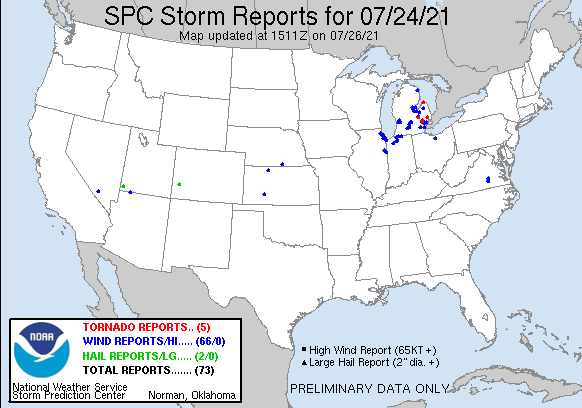
Above image depicts the local storm reports across the region for the July 24, 2021 severe weather. Heavy rainfall reports not shown. |
 |
|
National Storm Reports for July 24, 2021 |
Environment
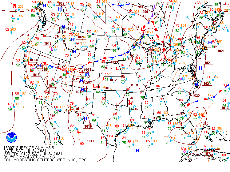
The environmental setup on the morning of July 24, 2021 had several processes in motion that led to widespread severe weather during the afternoon and evening periods. A warm front tied to southern Ontario surface low pressure was moving across Southeast Michigan from west to east Saturday morning ushering in a much more humid airmass. This would become an important factor in developing robust instability later in the day as surface dewpoints climbed into the low-mid 70s. Meanwhile, a ridge-running upper level shortwave trough was transiting along the US/Canada border, tilting into Lower Michigan within the mid to low levels. This supported upper level divergence and synoptic scale ascent while advecting low-mid level moisture to help saturate the column.
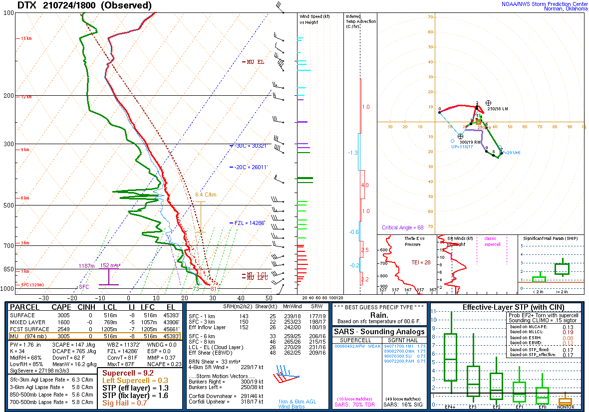
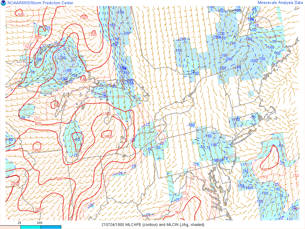
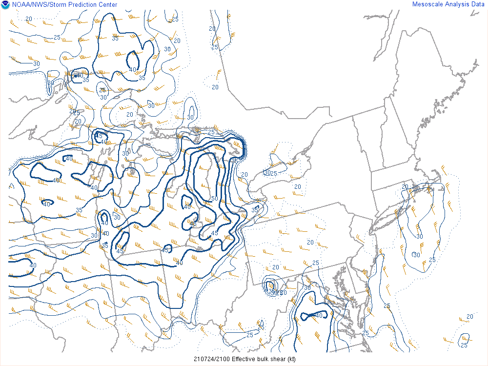
Fully entrenched within the warm sector, a special 18Z (2 PM EDT) balloon launch was performed to sample the atmosphere ahead of the strengthening lines of organized thunderstorms that were dropping southeast from the US-10 and M-55 corridors. The radiosonde data revealed an uncapped and unstable atmosphere with abundant moisture. The precipitable water value of 1.76 inches was well above the 90th percentile for sounding climatology with impressive surface-based instability (SBCAPE) of 3005 J/kg. Likewise, the measured kinematics revealed ample bulk shear (0-6 km) of 33 knots and very strong effective shear (EBWD) of 48 knots. There was also evidence of potential rotation in the lowest levels with computed 0-1 km storm-relative helicity (SRH) of 143 m2/s2 and slightly backed surface flow. Combined with very low lifted condensation levels (LCLs) in the 500-750 m AGL range (which lowered further during the evening), a favorable environment for spin-up tornadoes was revealed even as squall line and multicellular convective modes were dominant.
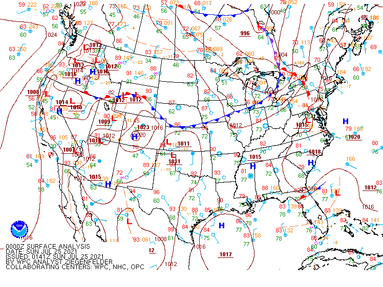
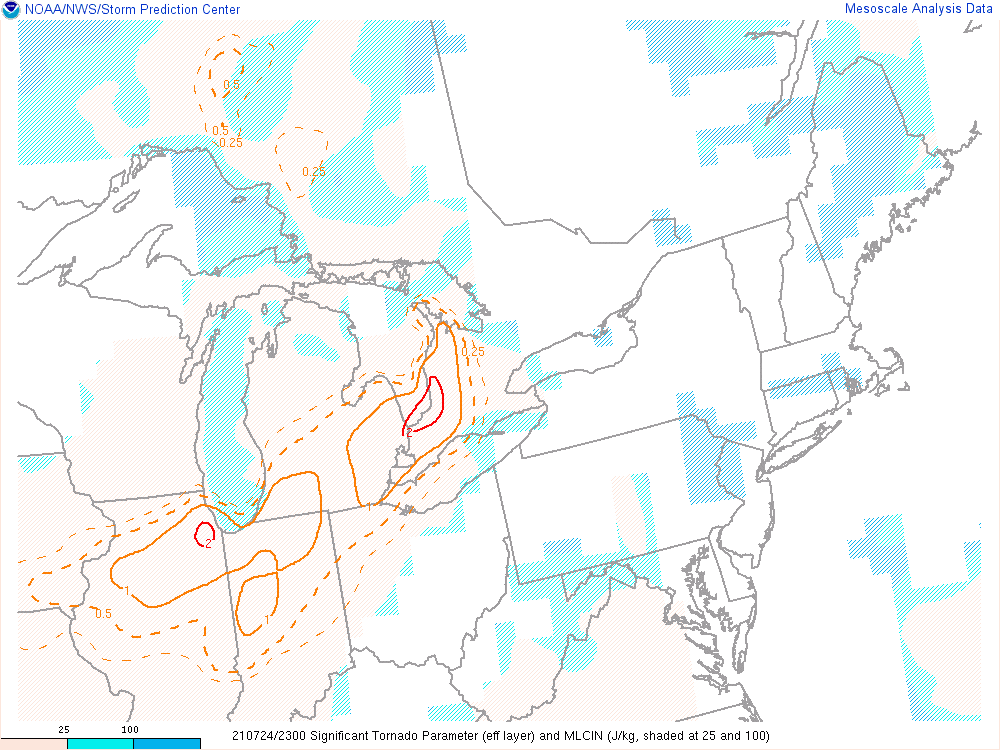
Strong to severe thunderstorm activity began around 4 PM along a well organized squall line moving southeast along I-75. By this time, low-level lapse rates (0-3 km) were pushing upwards of 6.5-7.0 C/km with +40 knots of effective shear and MLCAPEs peaking near 2000 J/kg across Metro Detroit. The broad coverage of this high-end parameter space helped maintain the forward speed and intensity of the main line causing it to broaden upon merging with a trailing line by the time it reached the M-59 corridor (around 00Z) where the seasonably strong cold front tied to the aforementioned low caught up. It was within the three hour window (6-9 PM EDT) when peak heating phased with the elevated shortwave (and frontogenesis) that the 0-1 km SRH values maximized across lower Southeast Michigan (100-250 m2/s2) with three tornadoes forming along the line. Accordingly, archived SPC mesoanalysis reveals composite Significant Tornado Parameter (effective-layer STP) values in the 1-2 range, absent of convective inhibition energy (MLCIN). Additionally, earlier in the day, a more isolated multicell storm moved across Outer Saginaw Bay producing a waterspout that eventually moved inland to become a tornado. This area was where early SRH was maximized, coincident with the best upper level support from the passing wave aloft.
With the large convective depths and previously mentioned high moisture/PWATs, the environment allowed thunderstorms to become efficient rainmakers. In many cases, southern portions of the warning area received only 60 minutes of rainfall, but rates were on the order of 1-2 inches, exhausting already strained stormwater management resources.
Click on the images below to see them expanded.
 |
 |
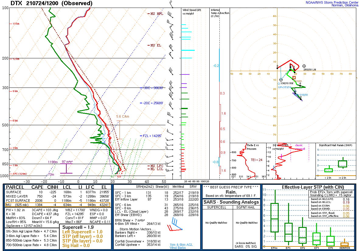 |
| Figure 1: Weather Prediction Center (WPC) surface map, valid 1800 UTC 24 July 2021. | Figure 2: Weather Prediction Center (WPC) surface map, valid 0000 UTC 25 July 2021. | Figure 3: KDTX observed sounding, valid 12 UTC 24 July 2021. |
 |
 |
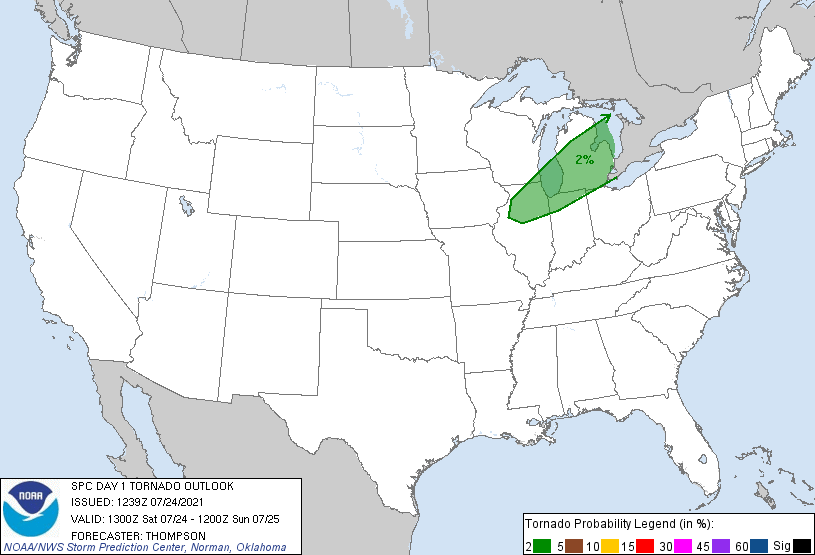 |
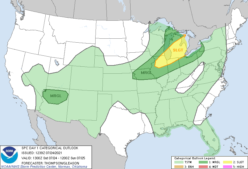
| Figure 4: KDTX observed sounding, valid 18 UTC 24 July 2021. | Figure 5: SPC Day 1 Outlook, valid 13 UTC 24 July 2021. | Figure 6: SPC Day 1 Tornado Outlook, valid 13 UTC 24 July 2021. |
 |
 |
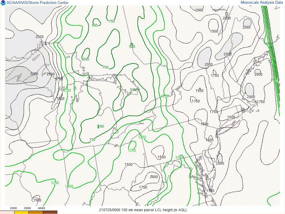 |
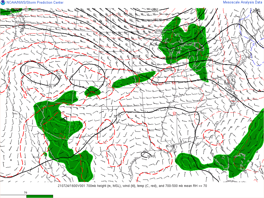
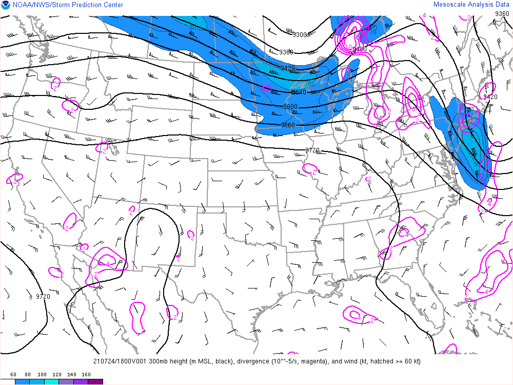
| Figure 7: Mixed-layer CAPE, valid 18 UTC 24 July 2021 | Figure 8: 0-6 km effective shear, valid 21 UTC 24 July 2021 | Figure 9: Lifted Condensation Level Height, valid 00 UTC 25 July 2021 |
 |
 |
 |
| Figure 10: Significant Tornado Parameter, valid 23 UTC 24 July 2021 | Figure 11: SPC 700 hPa Map, valid 16 UTC 24 July 2021. | Figure 12: SPC 300 hPa Map, valid 18 UTC 24 July 2021. |