Overview
Isolated severe storms developed over central Lower Michigan on the afternoon and evening of June 12, 2021, including a long-lived supercell. This storm produced significant hail - some up to baseball-sized in Ovid, MI (Clinton County) - and a few instances of wind damage as it tracked from the Mt. Pleasant area all the way to Ann Arbor before dissipating in the late evening. Other clusters of storms developed in the evening over northern and central Lower Michigan, one of which tracked across Midland and Bay Counties and resulted in localized damaging wind gusts.
Photos
 |
 |
|
Laingsburg Credit: Cameron Nixon |
Laingsburg Credit: Sarah Elizabeth |
 |
 |
|
Perry Credit: Kyle Piers |
Perry Credit: Cheryle Smith Eisen |
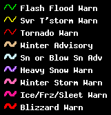
Radar
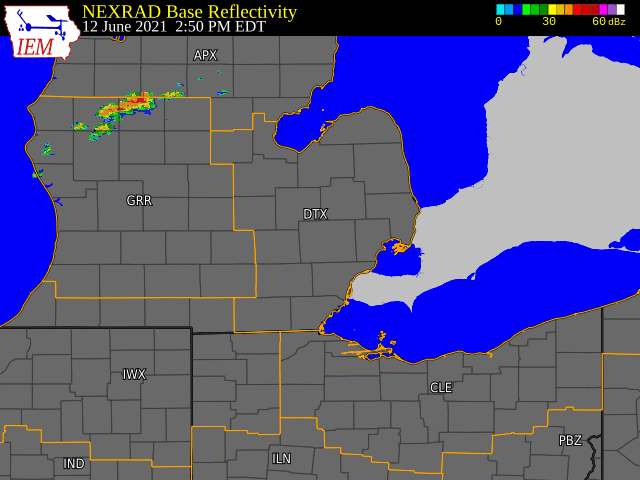  |
|
Click to Enlarge Radar loop courtesy of Iowa Environmental Mesonet (IEM) |
 |
|
Radar reflectivity image of the supercell near peak intensity at 2242 UTC 6/12/21. Image via GR2Analyst |
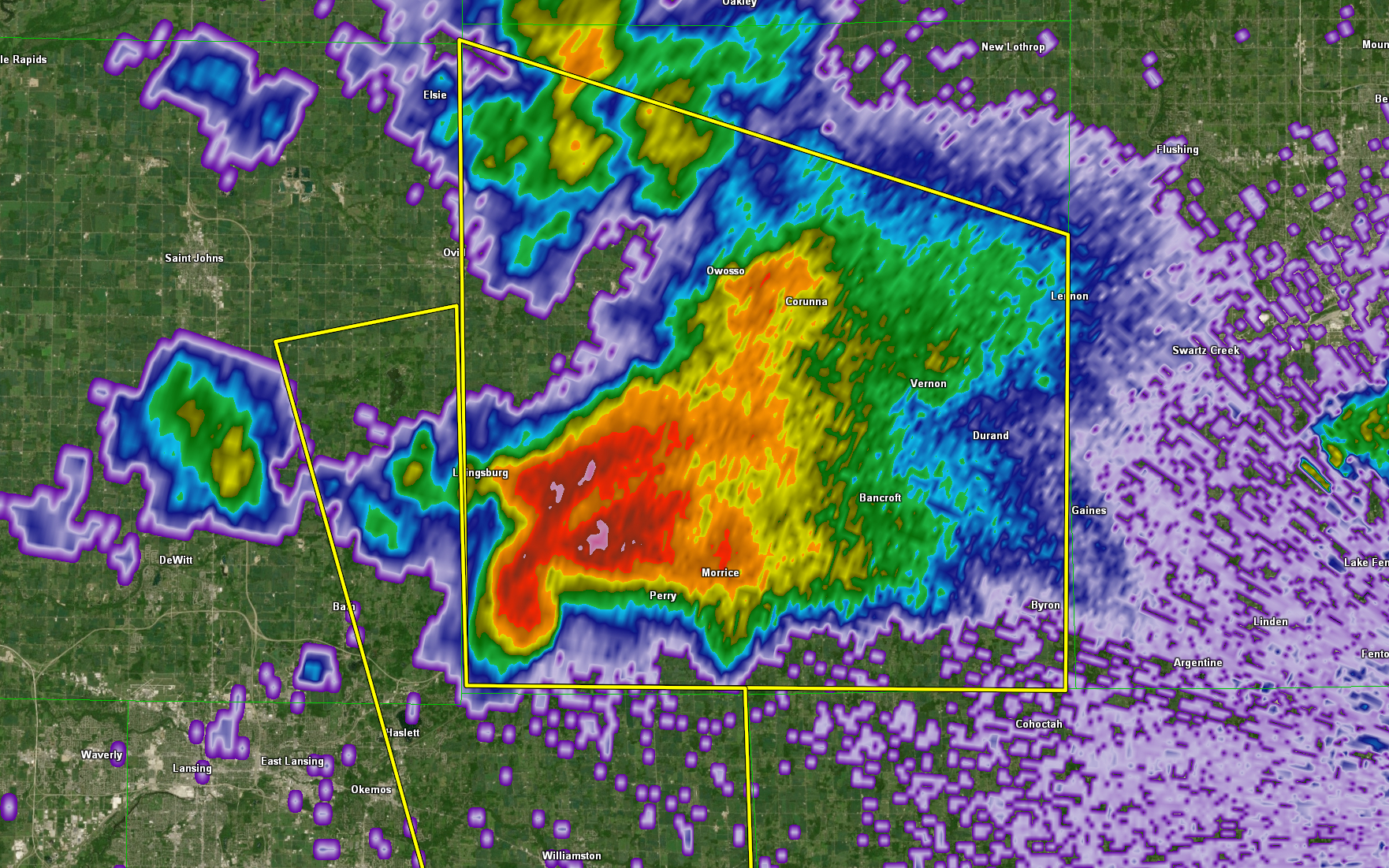
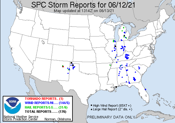
Storm Reports
 |
|
Map of Local Storm Reports |
Severe Weather Local Storm Reports:
PRELIMINARY LOCAL STORM REPORT...SUMMARY
NATIONAL WEATHER SERVICE DETROIT/PONTIAC MI
851 AM EDT SUN JUN 13 2021

..TIME...   ...EVENT...      ...CITY LOCATION...     ...LAT.LON...
..DATE...   ....MAG....      ..COUNTY LOCATION..ST.. ...SOURCE....
            ..REMARKS..

0633 PM     HAIL             LAINGSBURG              42.89N 84.35W
06/12/2021  M1.50 INCH       SHIAWASSEE         MI   TRAINED SPOTTER

            REPORT OF PING PONG SIZED HAIL ALONG WITH MULTIPLE TREES
            DOWN

0635 PM     HAIL             1 ENE LAINGSBURG        42.89N 84.34W
06/12/2021  M1.75 INCH       SHIAWASSEE         MI   TRAINED SPOTTER

            REPORT OF GOLF BALL SIZED HAIL AT PINE HILLS GOLF COURSE
            ALONG WITH TREES AND POWERLINES DOWN.

0645 PM     HAIL             PERRY                   42.82N 84.23W
06/12/2021  E1.25 INCH       SHIAWASSEE         MI   TRAINED SPOTTER

            HALF DOLLAR SIZED HAIL - PHOTO SUBMITTED VIA FACEBOOK.

0752 PM     TSTM WND DMG     4 WNW PINCKNEY          42.47N 84.02W
06/12/2021                   LIVINGSTON         MI   TRAINED SPOTTER

            MULTIPLE TREES DOWN ACROSS M-36 BETWEEN PINCKNEY AND
            GREGORY. REPORT RELAYED VIA WFO GRAND RAPIDS.

0832 PM     HAIL             DEXTER                  42.33N 83.88W
06/12/2021  M1.00 INCH       WASHTENAW          MI   TRAINED SPOTTER

            ALSO ESTIMATED 50 MPH WINDS.

0834 PM     TSTM WND DMG     4 ENE BOMBAY            43.75N 84.19W
06/12/2021                   MIDLAND            MI   911 CALL CENTER

            MIDLAND COUNTY CENTRAL DISPATCH REPORTED SEVERAL TREES
            DOWN NEAR E SHAFFER RD AND N WALDO RD.

0845 PM     HAIL             3 WNW ANN ARBOR         42.29N 83.78W
06/12/2021  M1.00 INCH       WASHTENAW          MI   TRAINED SPOTTER

            QUARTER SIZED HAIL REPORTED NEAR N MAPLE RD AND DEXTER
            AVE.

0910 PM     TSTM WND DMG     5 E AUBURN              43.60N 83.97W
06/12/2021                   BAY                MI   911 CALL CENTER

            BAY COUNTY CENTRAL DISPATCH REPORTED TREES DOWN NEAR FOUR
            MILE AND MIDLAND RDS.
 |
|
National Storm Reports for June 12, 2021 |
Environment
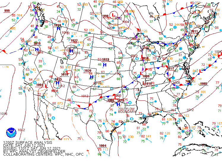
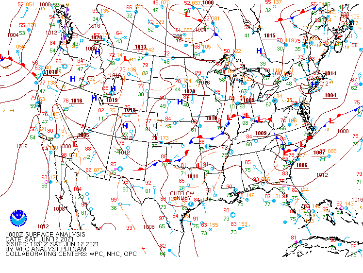
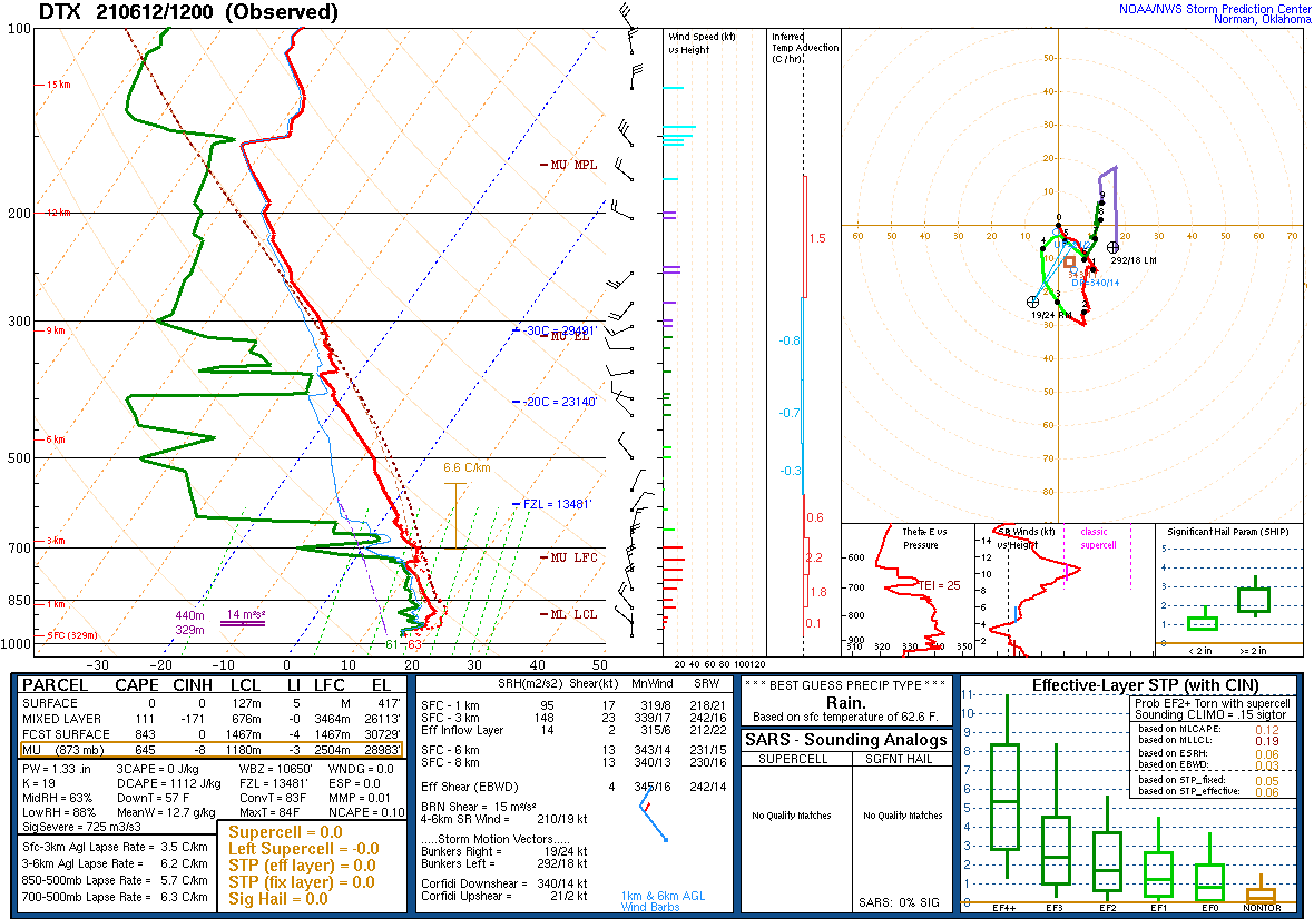
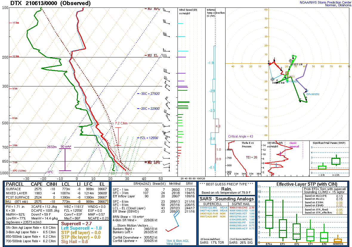
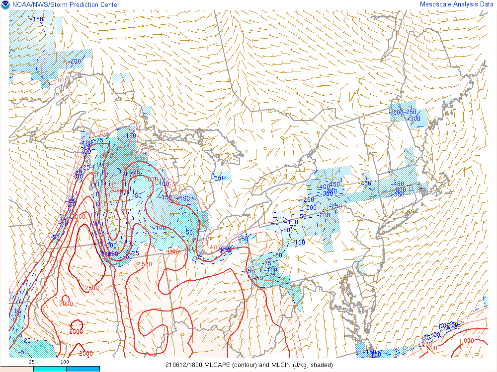
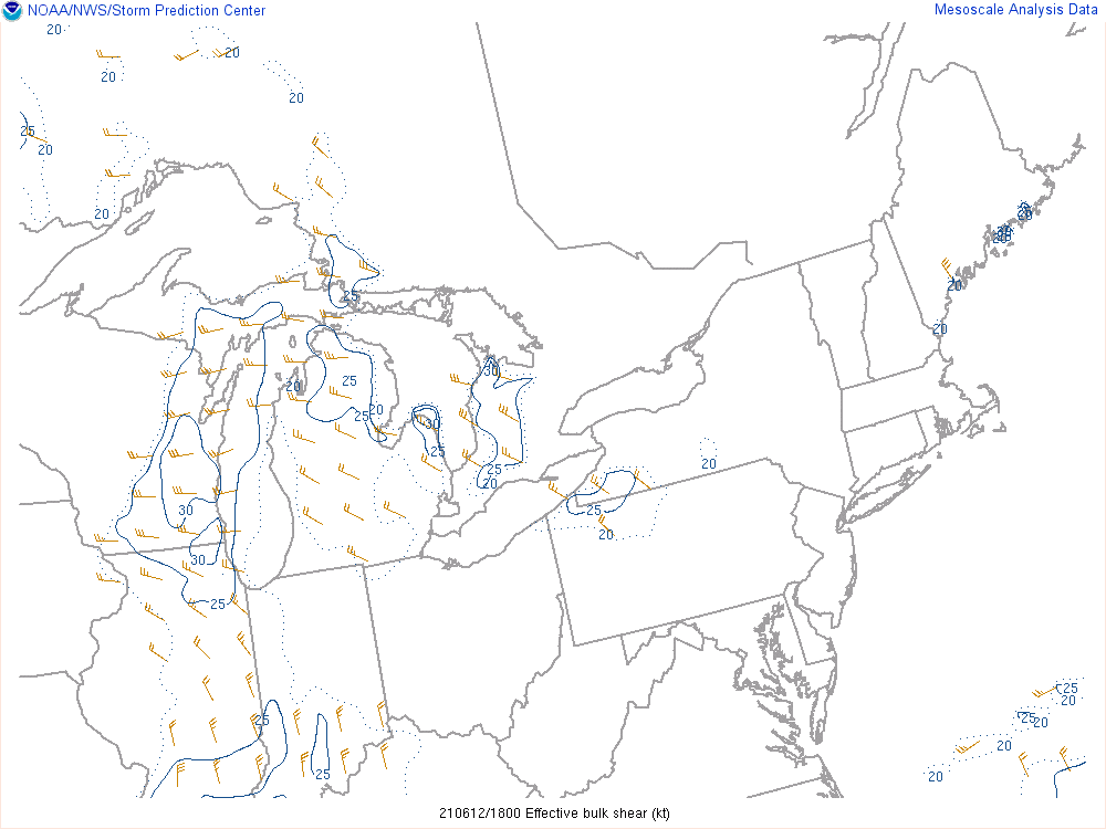
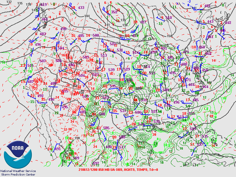
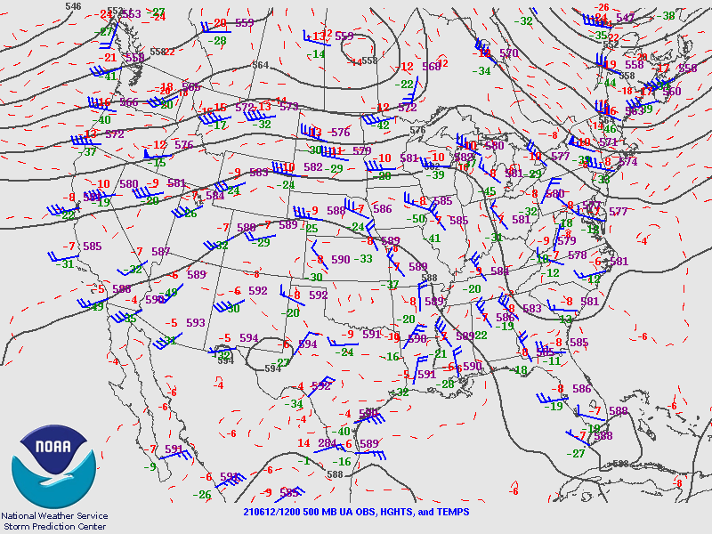
A weak ridge was in place over Southeast Michigan to start the day on June 12 (see Figure 11 below). An upper jet streak (Figure 12) and associated midlevel circulation moved into the Great Lakes during the day and led to subtle height falls that improved midlevel lapse rates. This, paired with moisture-rich lower levels with dew points rising into the upper 60s by late in the day, resulted in a very unstable atmosphere with MLCAPEs of around 1500 to 2000 J/kg (Figures 5 and 7). With the jet streak moving in, bulk wind shear increased through the day - coming in at around 30 to 40 kt by late afternoon (Figure 8). An initial cluster of showers and storms formed along a convergence axis over northwestern Lower Michigan (Mason and Lake Counties) and tracked east toward the Mid-Michigan area, reaching Mt. Pleasant around 4:30pm. The storms began to turn more to the south, which allowed the inflow to experience more favorable storm-relative helicity (Figure 9). The cluster then organized into a supercell which continued to dive south-southeast along the border between the NWS Grand Rapids and NWS Detroit County Warning Areas (CWAs) where plenty of instability sustained the storm. It produced significant (up to baseball-sized) hail just over the CWA border, in Clinton County, as well as prolific lightning and rainfall. After passing over Ann Arbor, the storm dissipated as diurnal instability waned and convective inhibition began to dominate. Meanwhile, another round of storms formed over north central Lower Michigan during the early evening and tracked into the Tri-Cities area, leading to a several isolated reports of damaging winds before weakening.
Click on the images below to see them expanded.
 |
 |
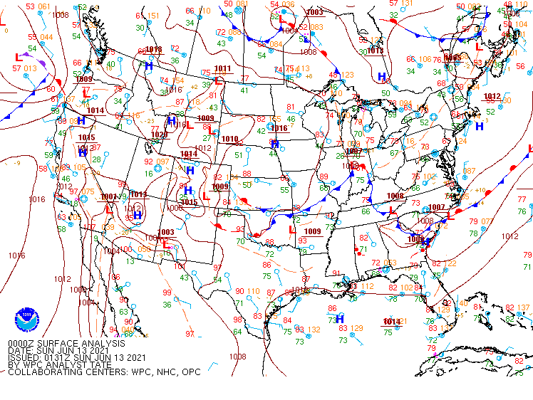 |
| Figure 1: Weather Prediction Center (WPC) surface map, valid 12 UTC 12 June 2021. | Figure 2: Weather Prediction Center (WPC) surface map, valid 18 UTC 12 June 2021. | Figure 3: Weather Prediction Center (WPC) surface map, valid 00 UTC 13 June 2021. |
 |
 |
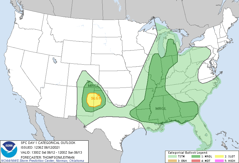 |
| Figure 4: KDTX observed sounding, valid 12 UTC 12 June 2021. | Figure 5: KDTX observed sounding, valid 00 UTC 13 June 2021. | Figure 6: SPC Day 1 Outlook, valid 13 UTC 12 June 2021. |
 |
 |
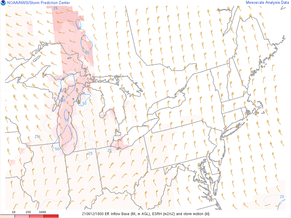 |
| Figure 7: Loop of mixed-layer CAPE, valid 18 UTC 12 June 2021 to 03 UTC 13 June 2021. | Figure 8: Loop of 0-6 km effective shear, valid 18 UTC 12 June 2021 to 03 UTC 13 June 2021. | Figure 9: Loop of effective storm-relative helicity, valid 18 UTC 12 June 2021 to 03 UTC 13 June 2021. |
 |
 |
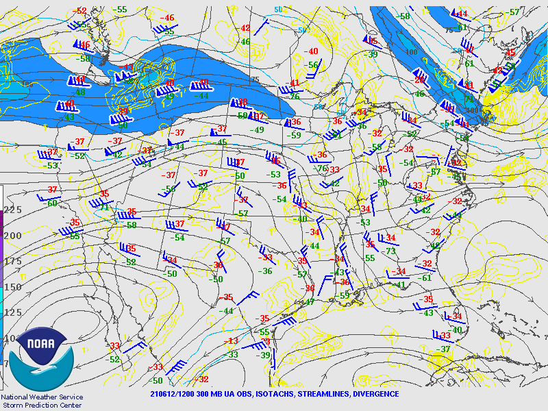 |
| Figure 10: SPC 850 hPa Map, valid 12 UTC 12 June 2021. | Figure 11: SPC 500 hPa Map, valid 12 UTC 12 June 2021. | Figure 12: SPC 300 hPa Map, valid 12 UTC 12 June 2021. |
 |
Media use of NWS Web News Stories is encouraged! Please acknowledge the NWS as the source of any news information accessed from this site. |
|

