Overview
A line of strong to severe storms tracked across Southeast Michigan on the afternoon of October 23, 2020 ahead of a strong cold front. An anomalously warm and humid air mass in place ahead of the front provided fuel for the storms while a strong upper trough produced ample wind shear and atmospheric lift. The storms led to numerous reports of wind damage (trees downed and damage to outbuildings or roofs) and several instances of hail. Tens of thousands of customers lost power across the state due to the storms.
Photos
 |
 |
 |
|
Elkton Credit: WLEW |
Kinde Credit: Joseph Ankley |
Dundee Credit: Isaac Polanski |
 |
 |
 |
|
Beecher Credit: Michelle Badders (via NBC25) |
Mt. Morris Credit: Missi (via NBC25) |
Clio Credit: Tiffany Blaska |
Radar
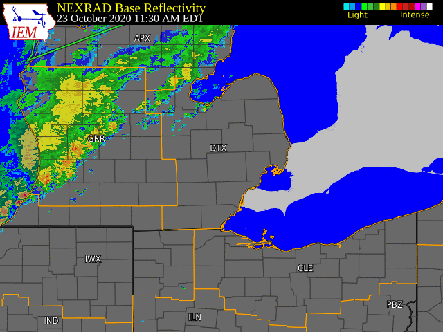  |
|
Click to Enlarge Radar loop courtesy of Iowa Environmental Mesonet (IEM) |
Storm Reports
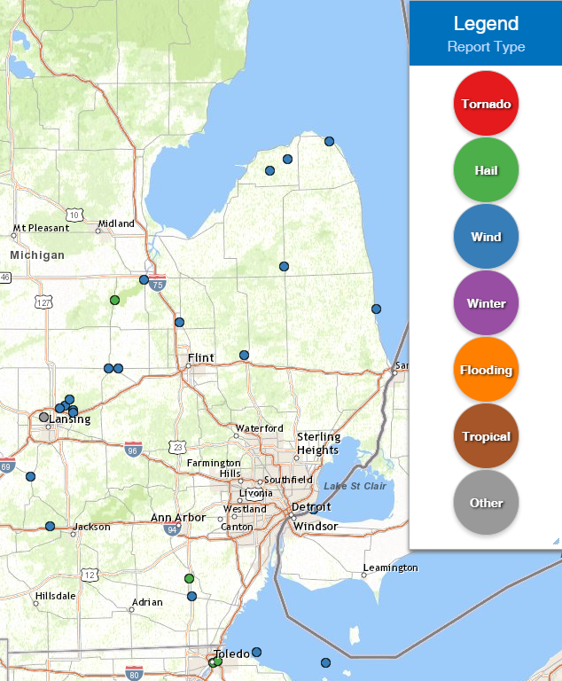 |
|
Map of Local Storm Reports |
Severe Weather Local Storm Reports:
PRELIMINARY LOCAL STORM REPORT...SUMMARY
NATIONAL WEATHER SERVICE DETROIT/PONTIAC MI
925 AM EDT SAT OCT 24 2020

..TIME...   ...EVENT...      ...CITY LOCATION...     ...LAT.LON...
..DATE...   ....MAG....      ..COUNTY LOCATION..ST.. ...SOURCE....
            ..REMARKS..

0108 PM     HAIL             1 NNE ST. CHARLES       43.31N 84.14W
10/23/2020  M1.00 INCH       SAGINAW            MI   PUBLIC

            MPING REPORT OF 1 INCH HAIL BY ST CHARLES. POWER OUTAGES
            ALSO REPORTED IN THE AREA.

0125 PM     TSTM WND DMG     2 SSW SAGINAW           43.40N 83.96W
10/23/2020                   SAGINAW            MI   911 CALL CENTER

            DISPATCH IS REPORTING WIRES DOWN AT RUSSEL AND GILMORE
            STREETS.

0200 PM     TSTM WND DMG     5 N ELKTON              43.89N 83.18W
10/23/2020                   HURON              MI   PUBLIC

            METAL GRAIN SILO BLOWN DOWN. THE ROOF OF THE GARAGE WAS
            ALSO BLOWN OFF AT THE SAME FARM.

0207 PM     TSTM WND DMG     4 W KINDE               43.94N 83.07W
10/23/2020                   HURON              MI   911 CALL CENTER

            MULTIPLE REPORTS RELAYED BY COUNTY DISPATCH OF TREES AND
            WIRES DOWN AROUND THE TOWNS OF PINNEBOG, KINDE, AND MEADE
            TWP. WIDESPREAD POWER OUTAGES ARE REPORTED ACROSS THOSE
            AREAS.

0212 PM     TSTM WND DMG     OWOSSO                  43.00N 84.18W
10/23/2020                   SHIAWASSEE         MI   TRAINED SPOTTER

            REPORT VIA HAM RADIO OF A LARGE TREE DOWN IN THE CITY OF
            OWOSSO.

0214 PM     TSTM WND DMG     3 E OWOSSO              43.00N 84.12W
10/23/2020                   SHIAWASSEE         MI   TRAINED SPOTTER

            HAM RADIO REPORT OF TREE AND BRANCHES DOWN NEAR N STATE
            RD AND M21.

0219 PM     TSTM WND DMG     1 ESE HURON CITY        44.02N 82.81W
10/23/2020                   HURON              MI   911 CALL CENTER

            COUNTY DISPATCH HAS MULTIPLE REPORTS OF TREES DOWN ALONG
            M25 BETWEEN PORT HOPE AND GRIND STONE CITY.

0236 PM     TSTM WND DMG     2 N CLIO                43.21N 83.74W
10/23/2020                   GENESEE            MI   BROADCAST MEDIA

            MEDIA RELAYED SOCIAL MEDIA REPORTS OF TREES DOWN TAKING
            DOWN WIRES WITH THEM IN CLIO. ADDITIONAL HAM RADIO REPORT
            VIA COUNTY DISPATCH OF MULTIPLE TREES AND WIRES DOWN
            ACROSS GENESEE COUNTY.

0247 PM     HAIL             3 S MILAN               42.04N 83.68W
10/23/2020  M1.00 INCH       MONROE             MI   TRAINED SPOTTER

            SPOTTER REPORT OF 1 INCH HAIL.

0301 PM     TSTM WND DMG     1 NW LAPEER             43.06N 83.34W
10/23/2020                   LAPEER             MI   911 CALL CENTER

            COUNTY DISPATCH REPORTS TREES DOWN NEAR W OREGON AND
            MILLVILLE RDS. MULTIPLE ADDITIONAL REPORTS OF TREES DOWN
            BETWEEN ELBA AND LAPEER CITY.

0312 PM     TSTM WND DMG     2 W DECKER              43.46N 83.09W
10/23/2020                   SANILAC            MI   911 CALL CENTER

            NUMEROUS TREES DOWN NEAR M53 AND SNOVER RD.

0400 PM     MARINE TSTM WIND 5 E CROSWELL            43.27N 82.52W
10/23/2020  M42.00 MPH       LHZ443             MI   MESONET

            36 KNOT GUST AT LEXINGTON HARBOR.

0406 PM     TSTM WND DMG     NNW DUNDEE              41.96N 83.66W
10/23/2020                   MONROE             MI   TRAINED SPOTTER

            PICTURE VIA SOCIAL MEDIA OF TREE SNAPPED AT DUNDEE HIGH
            SCHOOL.

0443 PM     MARINE TSTM WIND 2 S GROSSE POINTE       42.36N 82.91W
10/23/2020  M52.00 MPH       LCZ460             MI   MESONET

            45 KNOT GUST AT PECHE ISLAND LIGHT
 |
|
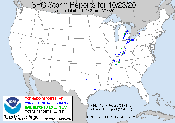
National Storm Reports for October 23, 2020 |
Environment
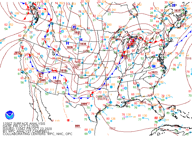
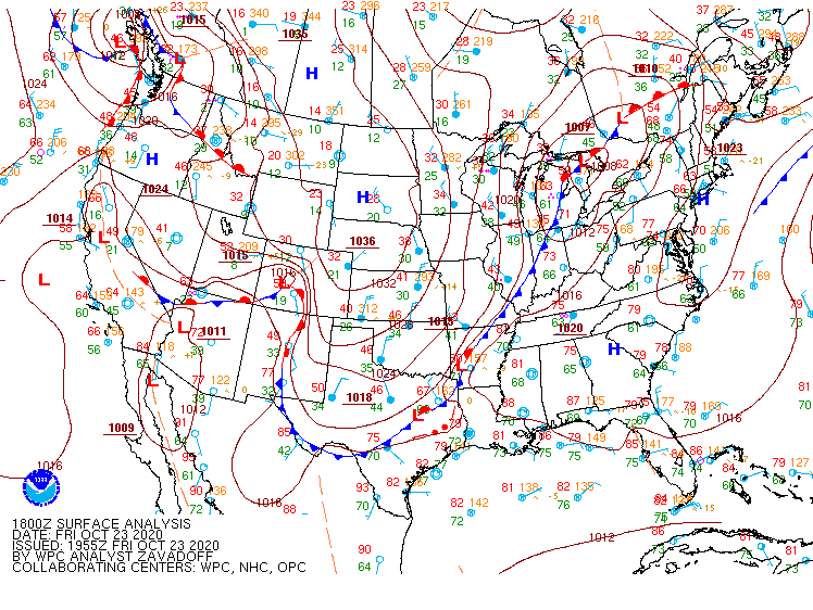
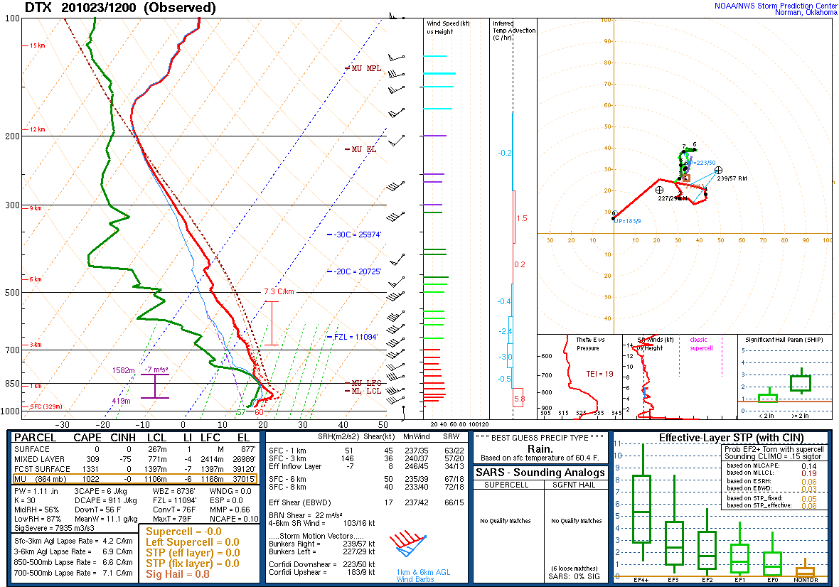
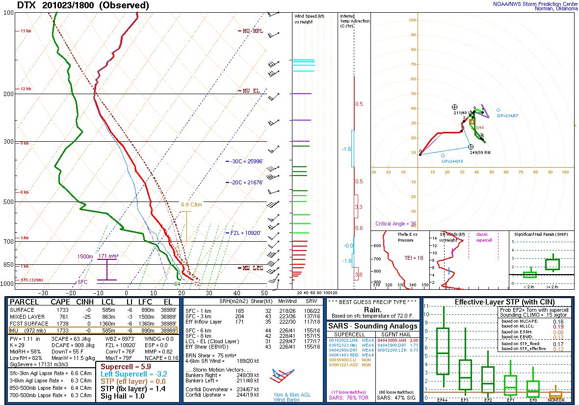
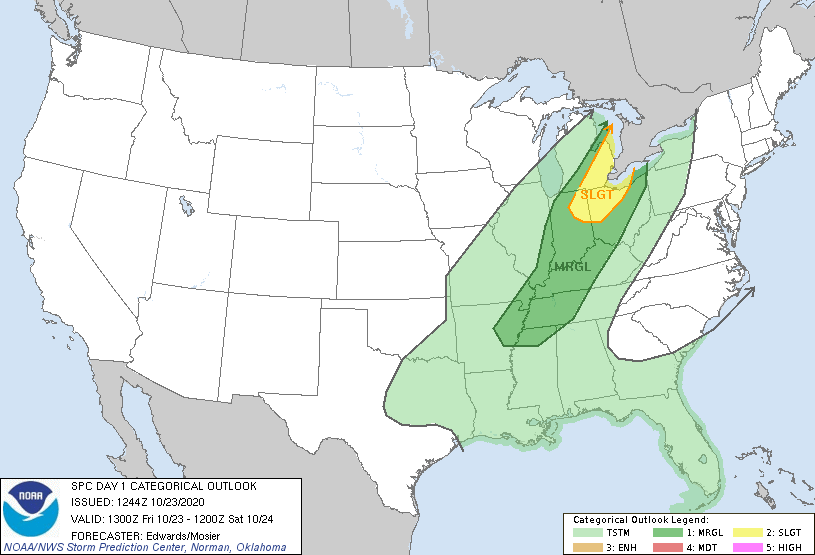
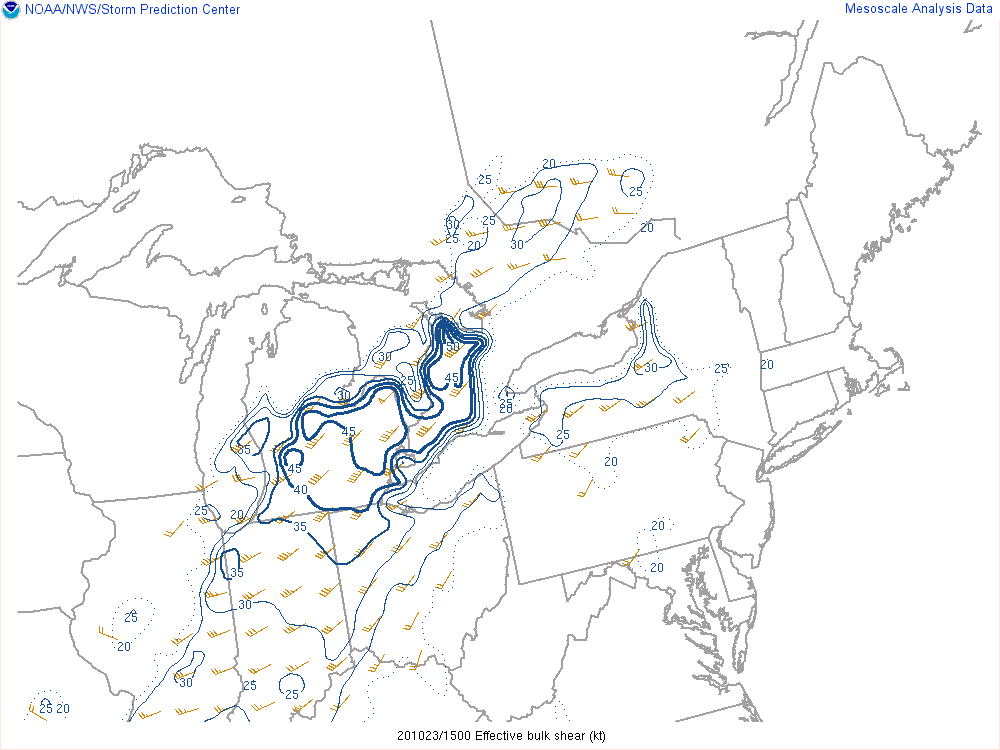
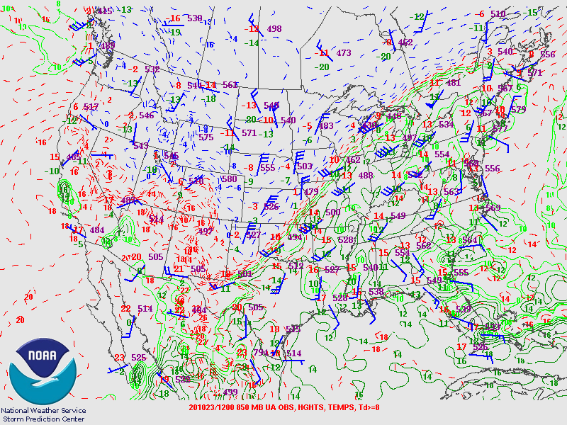
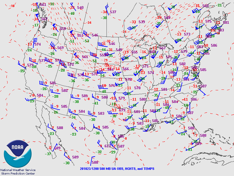
An upper trough (Figure 12) progressed across the north-central United States on October 22 with a sharp baroclinic zone draped from the Great Lakes west into the Midwest and central Plains. This trough led to the development of a low pressure system over the Plains that tracked across the mid-Mississippi Valley into the Great Lakes by October 23. The associated warm front lifted through lower Michigan by early on the 23rd with a very warm and increasingly humid air mass advecting into the area on strong southwest flow of nearly 50 kt just above the surface (Figure 10). As the daytime mixed layer developed, near-surface winds began gusting upwards of 25 to 35 mph during the early afternoon. Southeast Michigan started the day with mostly clear skies, which, paired with the warm sector taking residence, helped temperatures reach some 15 to 20 degrees above normal - well into the 70s with Monroe even reaching 80 degrees. (For reference, normal high temps in mid-late October are in the mid to upper 50s.) Dew points reached the upper 50s to 60s. The warm and humid low-level air mass allowed instability to build across the region ahead of the approaching cold front (Figures 1 and 2) as midlevel lapse rates sat around 6 to 7 degrees C / km (Figures 4 and 5). Effective wind shear of 35 to 45 kt (Figure 8) was in place ahead of the front due to the strong pressure gradient and momentum field ahead of the approaching trough. SPC outlined the area with a Day 1 Slight Risk (Figure 7) with all modes of severe weather possible.
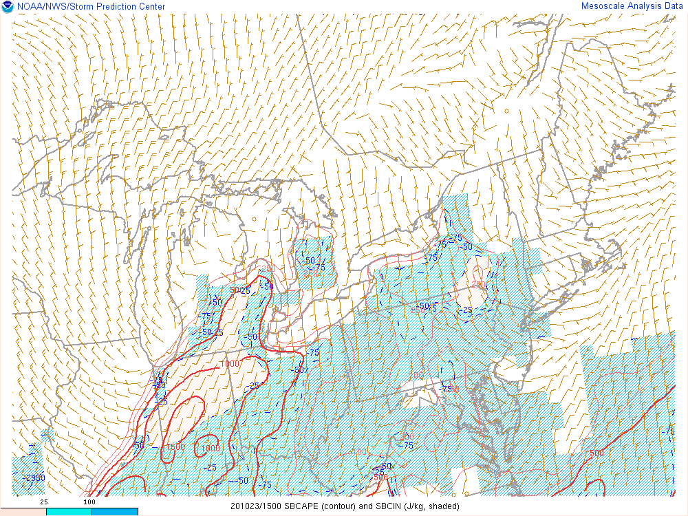
The large scale lift ahead of the trough and surface cold front led to a line of storms marching across the state during the early to mid afternoon. The storms strengthened with time as they tapped into the increasingly unstable air on the east side of the state where surface-based CAPE reached around 1500 J/kg (Figure 9). The leading storms lifted through the Saginaw Valley into the northern Thumb and exhibited a bowing structure which caused several reports of wind damage in those areas. Following this initial severe line segment, storms filled in across the rest of Southeast Michigan during the afternoon with the strongest portions of the line developing generally along the I-69 corridor and south of the Metro Detroit area. Reports received included downed trees and power lines, minor building damage, and a few reports of hail up to 1 inch. The cold front swept through late in the day with gusty northwest winds helping temperatures quickly fall to the 40s by late evening.
Click on the images below to see them expanded.
 |
 |
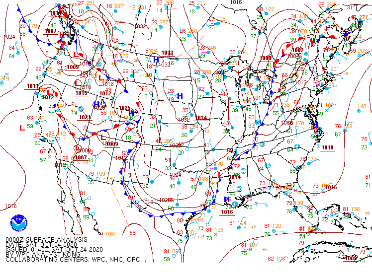 |
| Figure 1: Weather Prediction Center (WPC) surface map, valid 12 UTC 23 October 2020. | Figure 2: Weather Prediction Center (WPC) surface map, valid 18 UTC 23 October 2020. | Figure 3: Weather Prediction Center (WPC) surface map, valid 00 UTC 24 October 2020. |
 |
 |
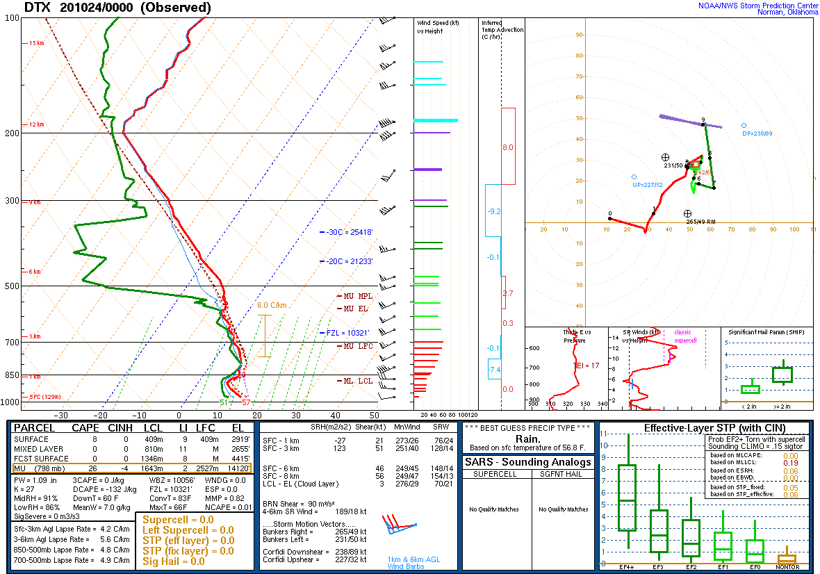 |
| Figure 4: KDTX observed sounding, valid 12 UTC 23 October 2020. | Figure 5: KDTX observed sounding, valid 18 UTC 23 October 2020. | Figure 6: KDTX observed sounding, valid 00 UTC 24 October 2020. |
 |
 |
 |
| Figure 7: SPC Day 1 Outlook, valid 13 UTC 23 October 2020. | Figure 8: Loop of 0-6 km effective shear, valid 15 UTC 23 October 2020 to 00 UTC 24 October 2020. | Figure 9: Loop of surface-based CAPE, valid 15 UTC 23 October 2020 to 00 UTC 24 October 2020. |
 |
 |
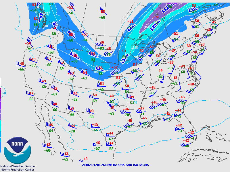 |
| Figure 10: SPC 850 hPa Map, valid 12 UTC 23 October 2020. | Figure 11: SPC 500 hPa Map, valid 12 UTC 23 October 2020. | Figure 12: SPC 250 hPa Map, valid 12 UTC 23 October 2020. |
 |
Media use of NWS Web News Stories is encouraged! Please acknowledge the NWS as the source of any news information accessed from this site. |
|

