Current Regional Radar

|
Current Hazards
|
Current Forecast
451
FZUS63 KDTX 151344
GLFLH
Open Lake Forecast for Lake Huron
National Weather Service Detroit/Pontiac MI
944 AM EDT Wed Jul 15 2026
For waters beyond five nautical miles off shore on Lake Huron
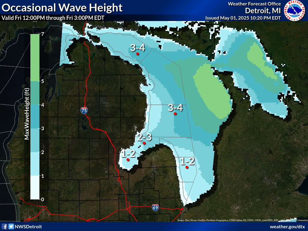
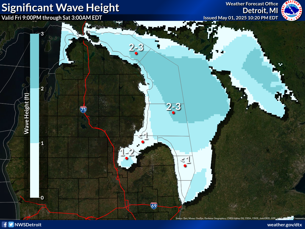
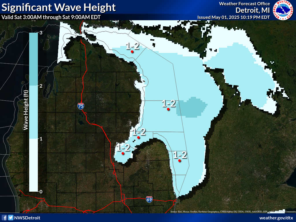
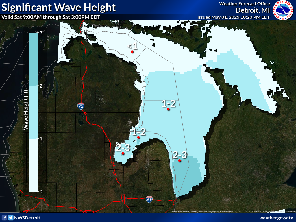
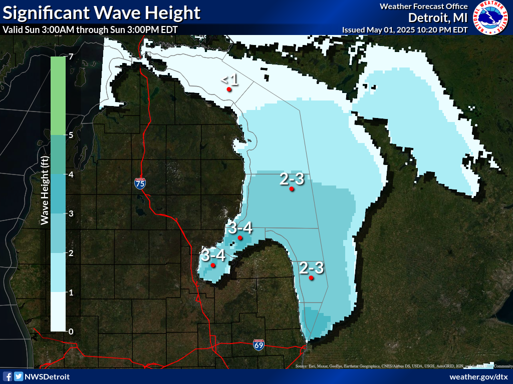
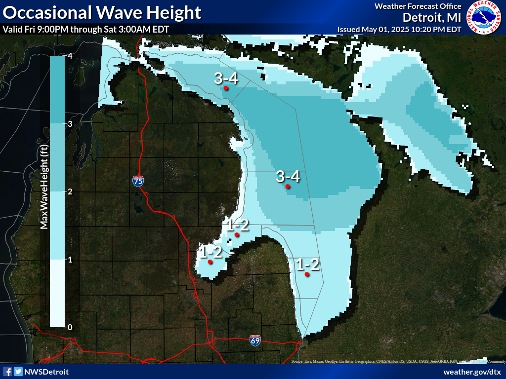
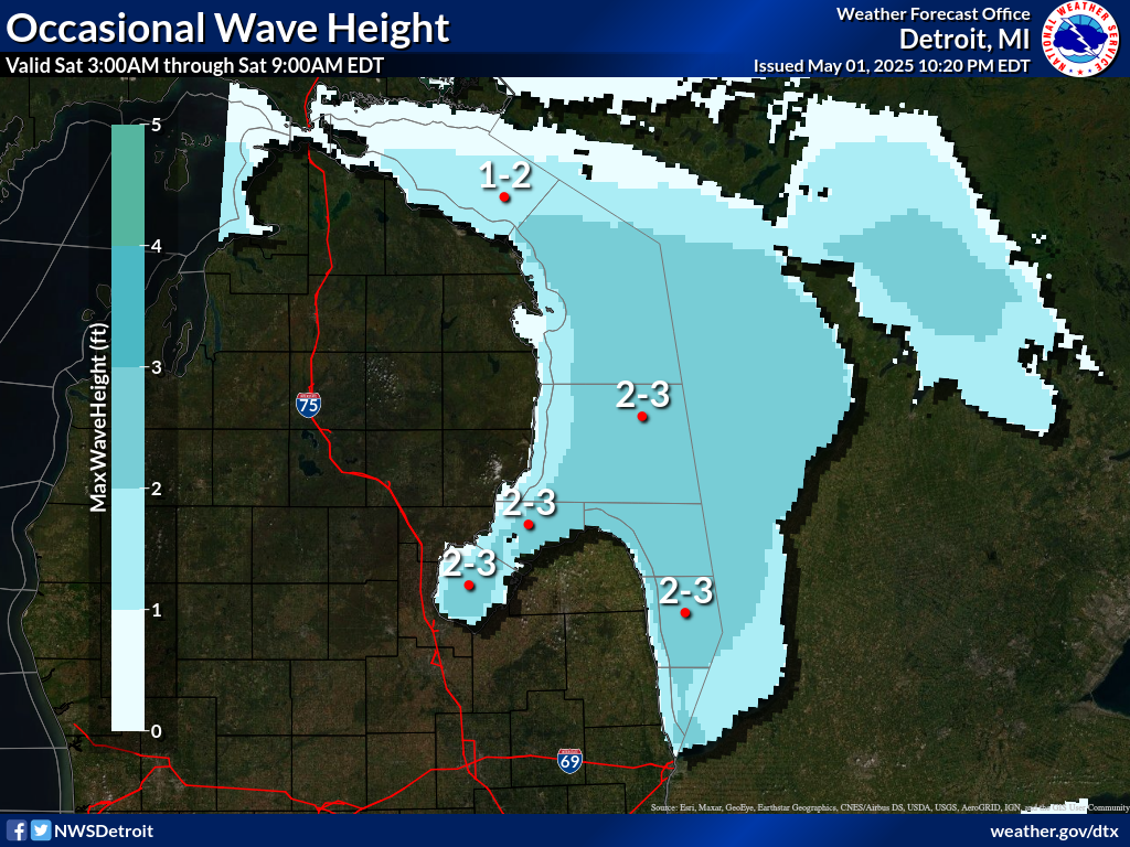
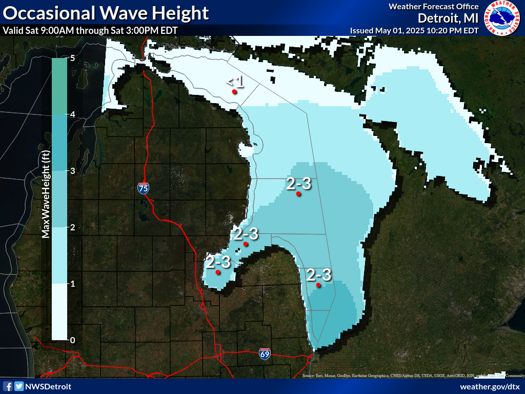
Waves are the significant wave height - the average of the highest
1/3 of the wave spectrum. Occasional wave height is the average of
the highest 1/10 of the wave spectrum.
.SYNOPSIS...A mainly dry cold front will drop south through the
Central Great Lakes tonight and Wednesday. Weak high pressure
follows for Thursday before the next low pressure system moves in
for the late week and early weekend time frame.
LHZ361-152145-
Lake Huron from 5NM east of Mackinac Bridge to Presque Isle Lt
beyond 5 NM off shore-
944 AM EDT Wed Jul 15 2026
...DENSE SMOKE ADVISORY IN EFFECT UNTIL 10 AM EDT THURSDAY...
.REST OF TODAY...Northwest winds 5 to 10 knots becoming west
10 to 15 knots late in the afternoon. Smoke. Waves 1 to 3 feet.
.TONIGHT...Northwest winds 10 to 15 knots. Smoke in the evening...
then areas of smoke after midnight. Waves 2 to 4 feet.
.THURSDAY...West winds 10 to 15 knots. Smoke in the morning.
Waves 1 to 3 feet.
.THURSDAY NIGHT...Northwest winds 10 to 15 knots becoming north
5 to 10 knots in the late evening and overnight. Waves 2 to
4 feet subsiding to 1 to 3 feet in the late evening and
overnight.
.FRIDAY...East winds 5 to 10 knots increasing to 10 to 15 knots
late in the morning...then becoming southeast 5 to 10 knots late
in the afternoon. A chance of showers...then showers likely late
in the afternoon. Waves 2 feet or less.
.SATURDAY...Southeast winds 10 to 15 knots backing to the north .
Showers likely early in the morning. A chance of showers in the
late morning and early afternoon. Waves 1 to 3 feet.
.SUNDAY...North winds 5 to 10 knots backing to the south . Waves
2 feet or less.
$$
LHZ362-363-152145-
Lake Huron from Presque Isle Light to Sturgeon Point MI beyond
5NM off shore-
Lake Huron from Sturgeon Point to Alabaster MI beyond 5NM off
shore-
944 AM EDT Wed Jul 15 2026
...DENSE SMOKE ADVISORY IN EFFECT UNTIL 10 AM EDT THURSDAY...
.REST OF TODAY...Northwest winds 5 to 10 knots increasing to
10 to 15 knots late in the afternoon. Smoke. Waves 1 to 3 feet.
.TONIGHT...Northwest winds 10 to 15 knots increasing to 15 to
20 knots late in the evening...then decreasing to 10 to 15 knots
after midnight. Smoke. Waves 3 to 5 feet.
.THURSDAY...Northwest winds 10 to 15 knots decreasing to 5 to
10 knots in the late morning and afternoon. Smoke in the morning.
Waves 2 to 4 feet subsiding to 1 to 3 feet in the late morning
and early afternoon...then building to 2 to 4 feet early in the
afternoon.
.THURSDAY NIGHT...Northwest winds 10 to 15 knots becoming north
5 to 10 knots in the late evening and overnight. Waves 2 to
4 feet subsiding to 1 to 3 feet after midnight.
.FRIDAY...Northeast winds 5 to 10 knots veering to the east. A
chance of showers...then showers likely late in the afternoon.
Waves 2 feet or less.
.SATURDAY...North winds 5 to 10 knots increasing to 10 to
15 knots . Showers likely early in the morning. A chance of
thunderstorms until early evening. A chance of showers early in
the evening. Waves 1 to 3 feet.
.SUNDAY...North winds 5 to 10 knots until afternoon becoming
light and variable...then becoming southeast 5 to 10 knots by
midnight. Waves 1 to 3 feet.
$$
LHZ462>464-152145-
Lake Huron from Port Austin to Harbor Beach beyond 5NM Off Shore-
Lake Huron from Harbor Beach to Port Sanilac beyond 5NM Off Shore-
Lake Huron from Port Sanilac to Port Huron beyond 5NM Off Shore-
944 AM EDT Wed Jul 15 2026
.REST OF TODAY...Light and variable winds becoming north 5 to
10 knots late in the afternoon. Patchy smoke late in the
morning...then smoke in the afternoon. Waves 2 feet or less.
.TONIGHT...North winds 5 to 10 knots backing to the northwest
early in the morning. Smoke. Waves 2 feet or less building to
2 to 4 feet after midnight.
.THURSDAY...Northwest winds 5 to 10 knots. Smoke in the morning.
Waves 2 to 4 feet subsiding to 1 to 3 feet in the late morning
and afternoon.
.THURSDAY NIGHT...Light and variable winds. Waves 2 feet or less.
.FRIDAY...Light and variable winds becoming southeast 5 to
10 knots late in the morning...then backing to the east late in
the afternoon. A chance of thunderstorms late in the afternoon.
Rain showers likely and a chance of thunderstorms late in the
evening. Waves 2 feet or less.
.SATURDAY...South winds 5 to 10 knots veering to the southwest in
the late morning and early afternoon...then becoming north 10 to
15 knots . Showers likely. A chance of thunderstorms until early
evening...then a chance of showers by midnight. Waves 2 feet or
less building to 2 to 4 feet .
.SUNDAY...North winds 10 to 15 knots decreasing to 5 to 10 knots
until early evening...then veering to the east by midnight. Waves
2 to 4 feet subsiding to 1 to 3 feet.
$$
LHZ461-152145-
MAFOR 1515/
HURON NORTH 11700 11610 12720 14710. Waves 1 to 3 feet this
afternoon. Waves 3 to 5 feet tonight. Waves 1 to 3 feet Thursday
morning.
HURON SOUTH 11700 12800 13710 12700. Waves 2 feet or less this
afternoon. Waves 2 feet or less building to 2 to 4 feet tonight.
Waves 1 to 3 feet Thursday morning.
$$
SS
Experimental modernized open lake forecast is available online at
weather.gov/dtx/glftable (all lower case)
Graphical marine forecasts are available online at
weather.gov/greatlakes (all lower case)