Current Regional Radar

|
Current Hazards
|
Current Forecast
477
FZUS61 KCLE 101946
GLFLE
Open Lake Forecast for Lake Erie
National Weather Service Cleveland OH
346 PM EDT Fri Jul 10 2026
For waters beyond five nautical miles of shore on Lake Erie
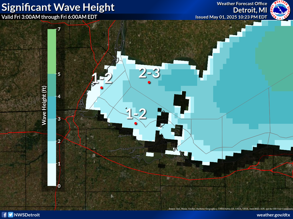
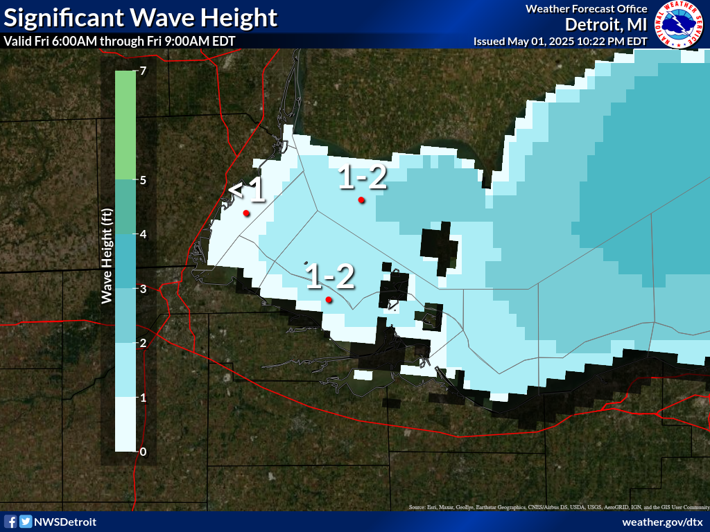
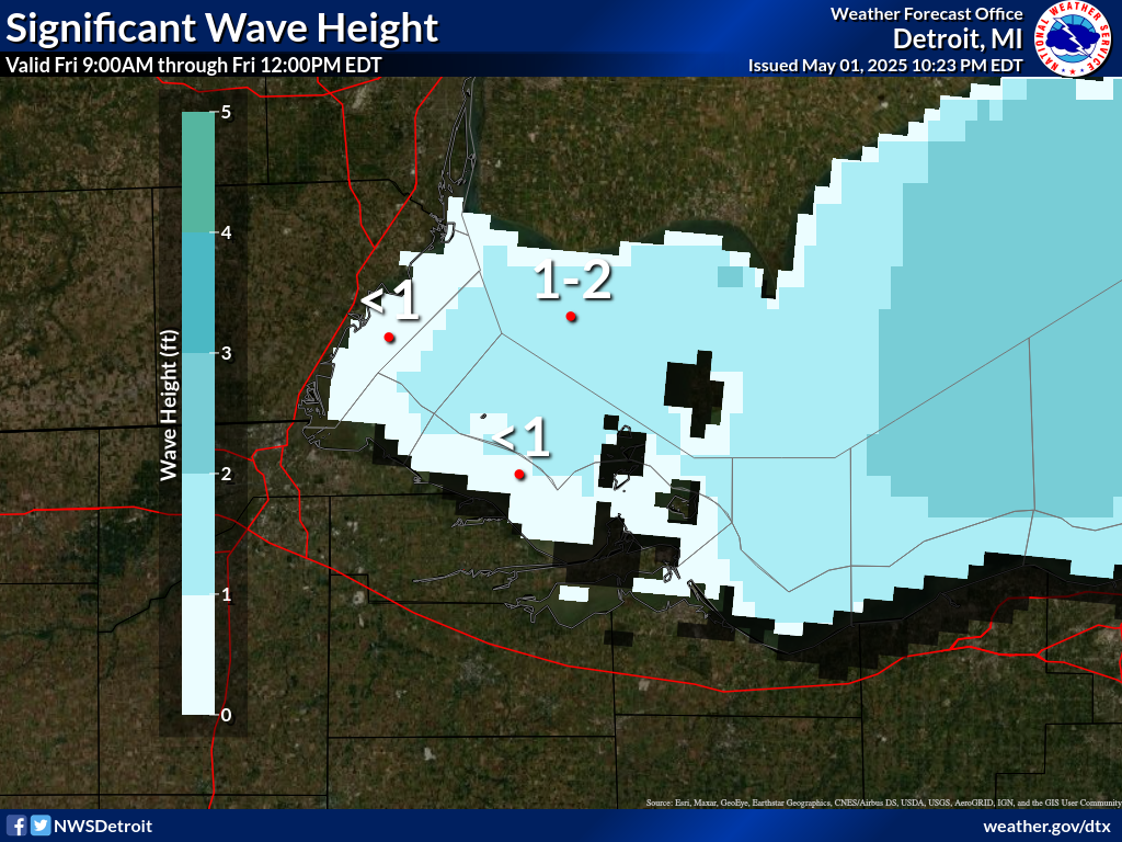
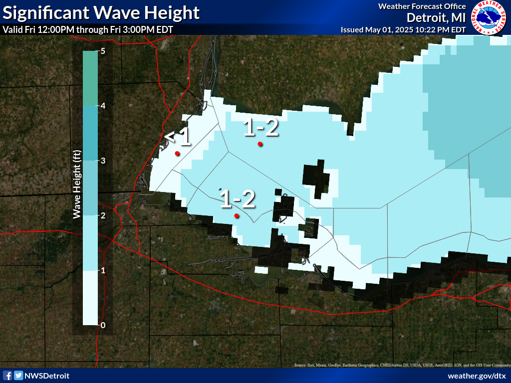
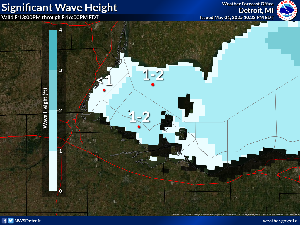
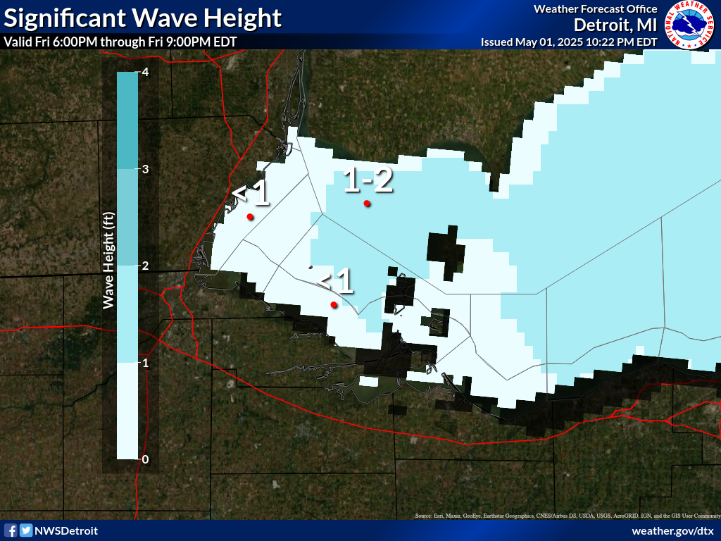
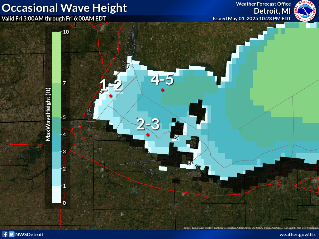
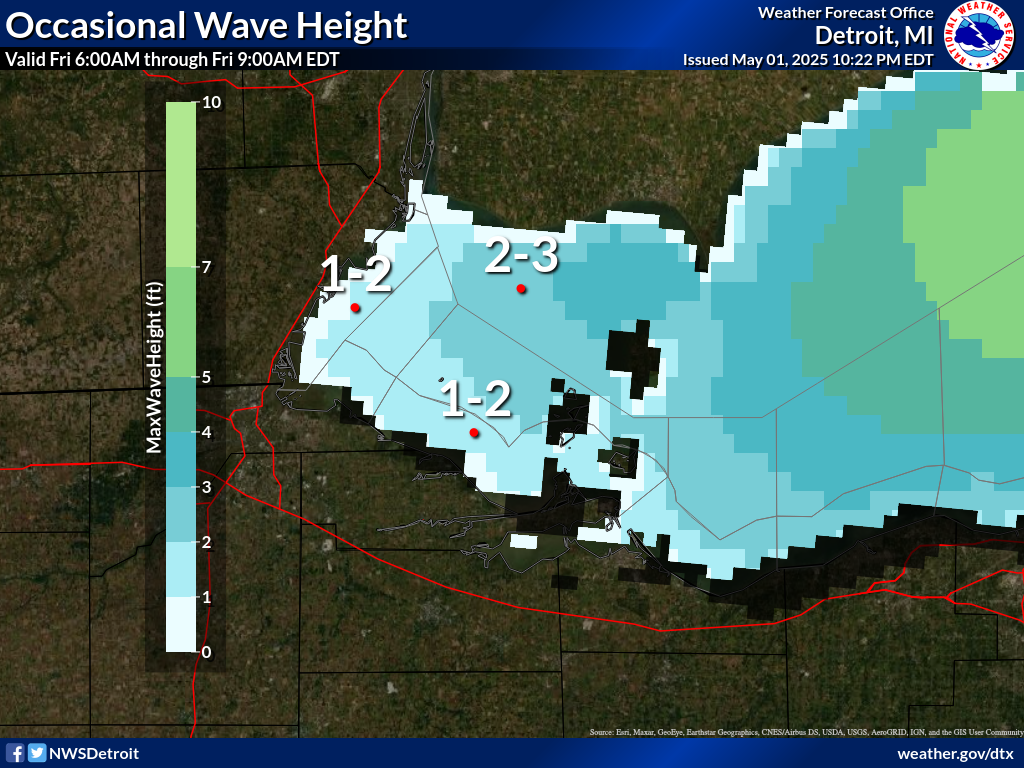
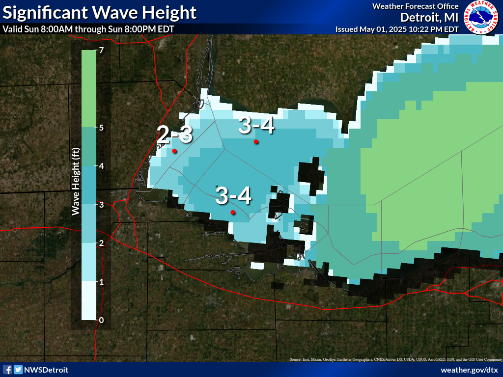
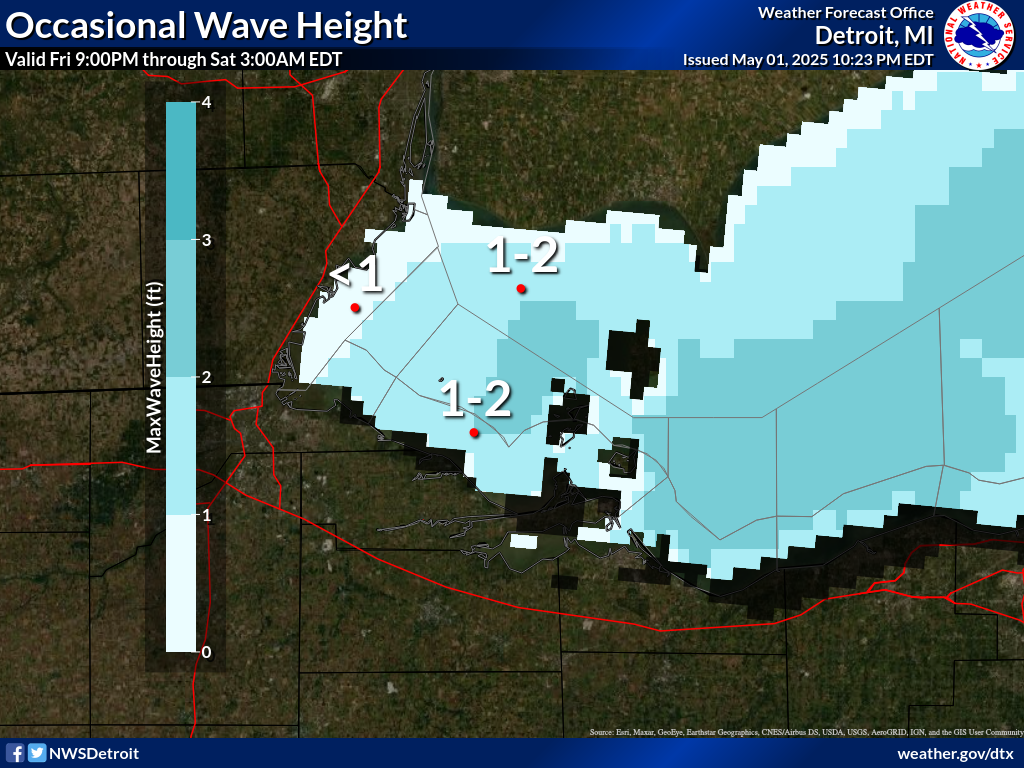
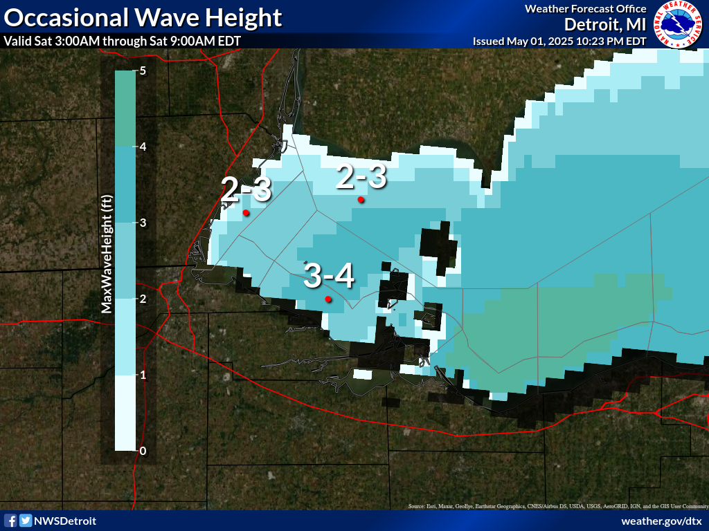
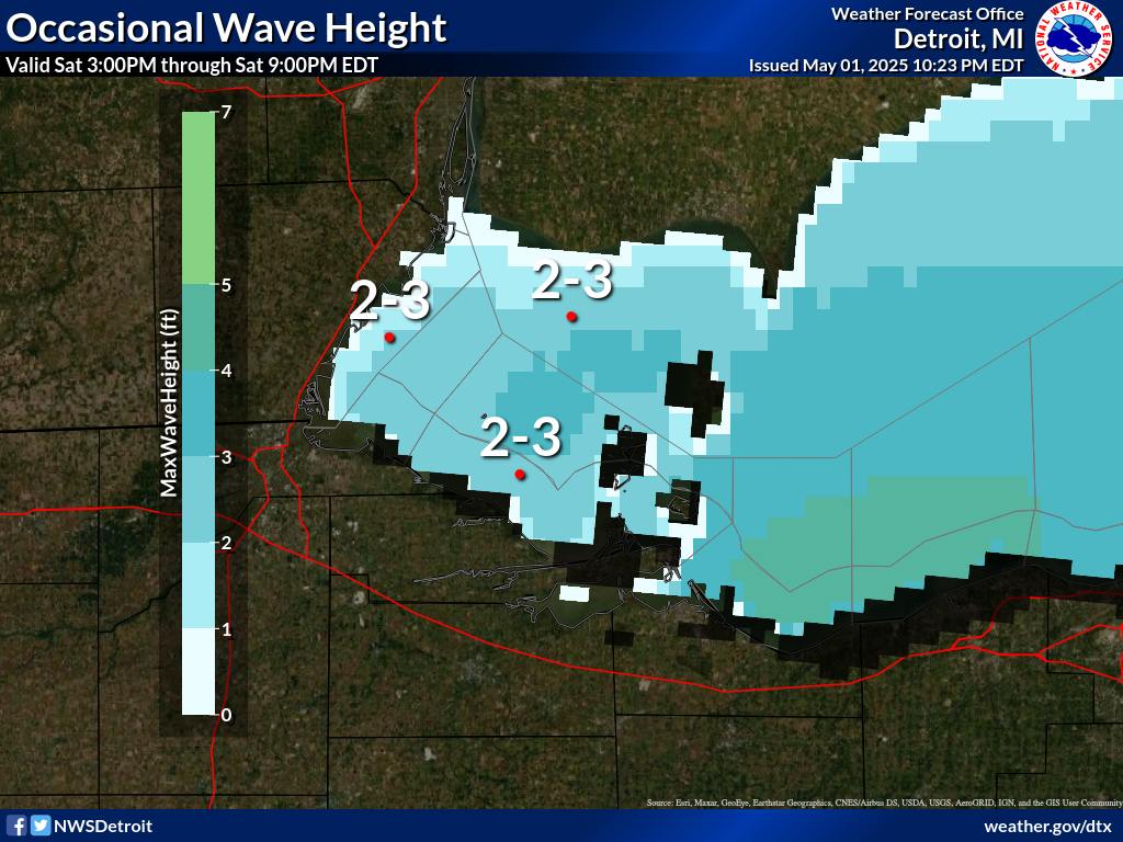
Waves are the significant wave height - the average of the highest
1/3 of the wave spectrum. Occasional wave height is the average of
the highest 1/10 of the wave spectrum.
.SYNOPSIS...
A weak cold front will continue to move south across Ohio tonight.
Low pressure of 29.90 inches will move east through the Ohio
Valley on Saturday. High pressure of 30.10 inches will build over
the Central Great Lakes on Sunday then settles south to the Ohio
Valley through the first half of next week.
LEZ162-163-110230-
Detroit River Lt. to Maumee Bay OH to Reno Beach OH beyond 5NM
offshoreline to US-Canadian border-
Reno Beach to The Islands OH beyond 5NM off shoreline to US-
Canadian border-
346 PM EDT Fri Jul 10 2026
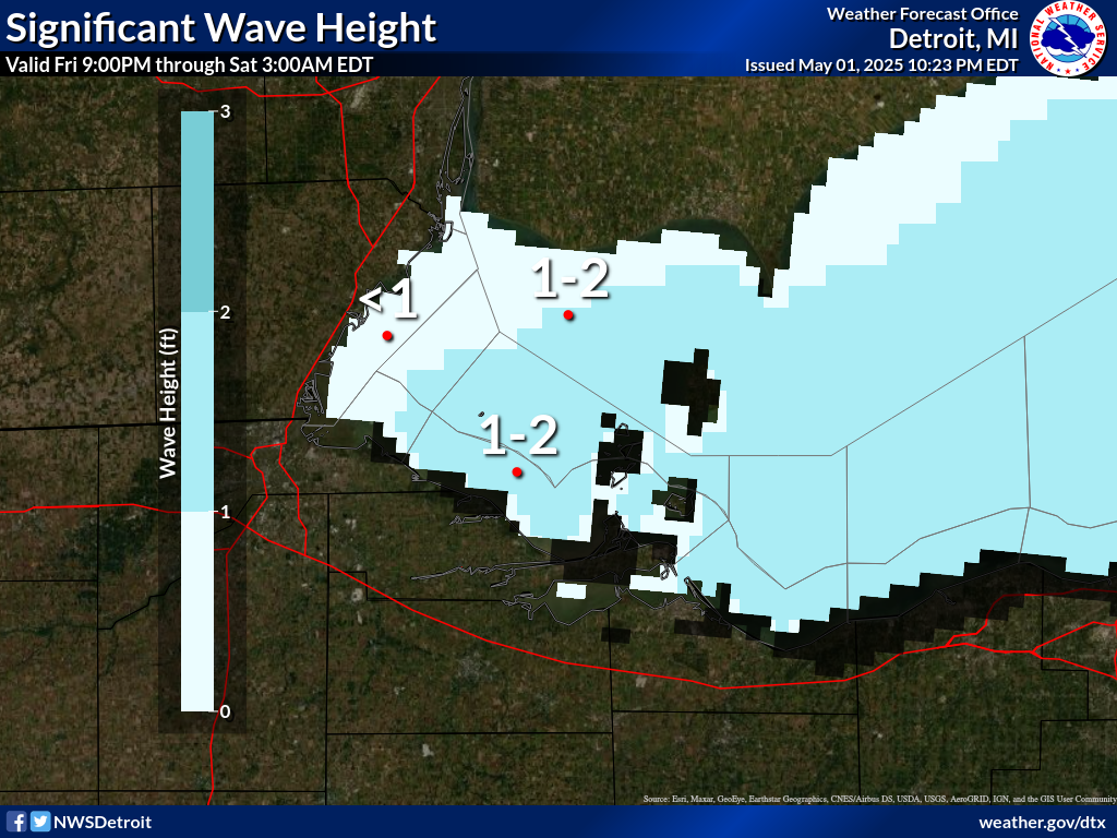
.TONIGHT...East winds 10 knots or less becoming northeast. A
slight chance of showers and thunderstorms early. Waves 1 foot or
less.
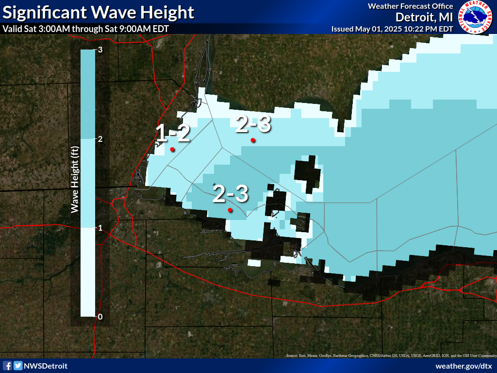
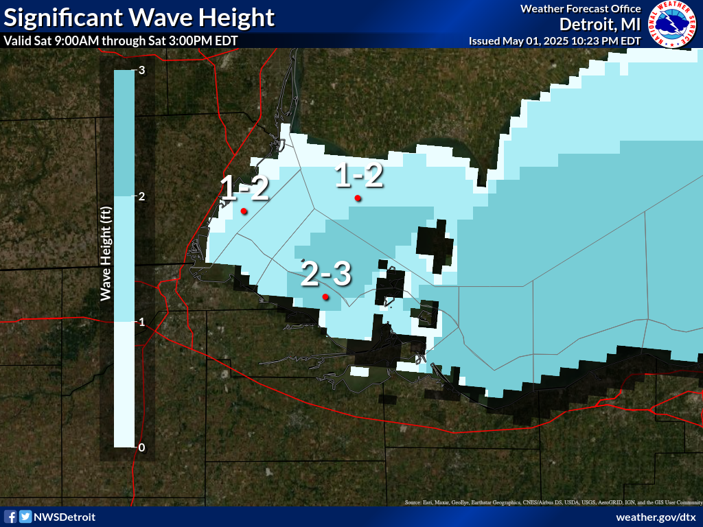
.SATURDAY...Northeast winds 10 to 15 knots becoming east. Waves
1 to 3 feet.
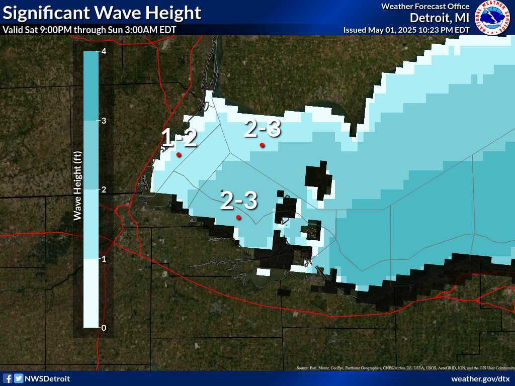
.SATURDAY NIGHT...East winds 5 to 15 knots. Waves 1 to 3 feet.
.SUNDAY...East winds 5 to 15 knots. Waves 2 feet or less.
.SUNDAY NIGHT...East winds 5 to 15 knots diminishing to less than
10 knots. Waves 1 to 3 feet subsiding to 1 foot or less.
.MONDAY...East winds 10 knots or less becoming southwest. Waves
1 foot or less.
.TUESDAY...West winds 5 to 10 knots. Waves 2 feet or less.
.WEDNESDAY...West winds 5 to 10 knots becoming northwest. Waves
2 feet or less.
Winds and waves higher in and near thunderstorms.
$$
LEZ164>167-110230-
The Islands to Vermilion OH beyond 5 nm off shoreline to US-
Canadian border-
Vermilion to Avon Point OH beyond 5 nm off shoreline to US-
Canadian border-
Avon Point to Willowick OH beyond 5 nm off shoreline to US-
Canadian border-Willowick to Geneva-on-the-
Lake OH beyond 5NM off shoreline to US-Canadian border-
346 PM EDT Fri Jul 10 2026
.TONIGHT...Northeast winds 10 knots or less. A slight chance of
showers and thunderstorms early. Waves 1 foot or less.
.SATURDAY...Northeast winds 5 to 15 knots increasing to 15 to
20 knots. Waves 1 to 3 feet.
.SATURDAY NIGHT...Northeast winds 15 to 20 knots becoming east
5 to 15 knots. Waves 2 to 4 feet subsiding to 1 to 2 feet.
.SUNDAY...East winds 5 to 15 knots becoming northeast. Waves 1 to
3 feet.
.SUNDAY NIGHT...Northeast winds 5 to 15 knots becoming east less
than 10 knots. Waves 1 to 3 feet subsiding to 1 foot or less.
.MONDAY...Southeast winds 10 knots or less becoming southwest.
Waves 1 foot or less.
.TUESDAY...Southwest winds 5 to 15 knots becoming west. Waves
1 to 3 feet.
.WEDNESDAY...West winds 10 to 15 knots becoming north. Waves 1 to
3 feet.
Winds and waves higher in and near thunderstorms.
$$
LEZ061-168-169-110230-
Ripley to Buffalo NY extending from 5NM off shoreline to US-
Canadian border-Geneva-on-the-
Lake to Conneaut OH beyond 5 nm off shoreline to US-
Canadian border-
Conneaut OH to Ripley NY beyond 5 nm off shoreline to US-
Canadian border-
346 PM EDT Fri Jul 10 2026
.TONIGHT...Northeast winds 10 knots or less. Waves 1 foot or
less.
.SATURDAY...Northeast winds 5 to 15 knots. Waves 1 to 3 feet.
.SATURDAY NIGHT...Northeast winds 5 to 15 knots becoming east.
Waves 1 to 3 feet.
.SUNDAY...East winds 5 to 10 knots becoming northeast. Waves
2 feet or less.
.SUNDAY NIGHT...Northeast winds 10 knots or less becoming
southeast. Waves 2 feet or less.
.MONDAY...South winds 10 knots or less becoming southwest. Waves
1 foot or less.
.TUESDAY...Southwest winds 10 to 15 knots becoming west. Waves
1 to 3 feet.
.WEDNESDAY...West winds 5 to 15 knots becoming northwest. Waves
1 to 3 feet.
Winds and waves higher in and near thunderstorms.
$$
LEZ161-110230-
MAFOR 1021/
ERIE WEST 1/3 15100 12110. Waves 1 foot or less tonight. Waves 1
to 3 feet Saturday.
ERIE CENTRAL 1/3 15100 12110. Waves 1 foot or less tonight. Waves
2 feet or less building to 2 to 3 feet Saturday.
ERIE EAST 1/3 11100 11800 14100 12110. Waves 2 feet or less.
$$