| Overview | Wind Chills | Graphics | Additional Resources |
Quickly following on the heels of the January 4-5th winter storm; arctic air overtook much of the Midwest, including southeast Michigan. Average temperatures were approximately 20 to 30 degrees below normal for this time of year! This frigid air and winds helped to create dangerous wind chills between January 6-8th. Both wind chill advisories and warnings were in effect during that time, with some locations recording 40 below wind chills! Coldest temperatures at the three climate sites can be found below, including at the NWS White Lake office (not an official climate site). The following coldest temperatures occurred overnight on January 6-7th.
| Location | Temperature | |
| Detroit Metro Airport | -14 | |
| Flint Bishop Airport | -14 | |
| Tri-Cities/Saginaw | -11 | |
| White Lake (NWS) | -17 | |
During this stretch, Detroit managed to stay below zero for 42 hours! The Detroit area first went below zero at 4 pm on January 6th and did not see above zero readings until 10 am on Janurary 8th. Flint and Saginaw did not see as long of duration below zero as Detroit, but both still managed to stay below zero for 18 hours.
| Site | # of hours consecutively below zero |
| Detroit (DTW) | 42 hours |
| Flint (FNT) | 18 hours |
| Saginaw (MBS) | 18 hours |
Wind chill advisories are issued when wind chill temperatures are expected to be a significant inconvenience to life with prolonged exposure, and, if caution is not taken, could lead to hazardous exposure. Wind chill warnings, on the other hand, are issued when temperatures are expected to be hazardous to life within several minutes of exposure.
Much of the county warning area (CWA), saw wind chill warning criteria being met for over 24 straight hours. Detroit area met that for about 24 hours, with the coldest wind chill reading of -41 degrees occurring at 1:53am (1/7). The Flint area met warning criteria for about 28 hours, with the coldest wind chill reading of -35 degrees occurring at 11:53pm (1/6). The Saginaw Valley/Tri-Cities area saw a shorter duration for warning criteria lasting about 15 hours, with the coldest wind chill reading of -35 degrees at 2:52am (1/7).

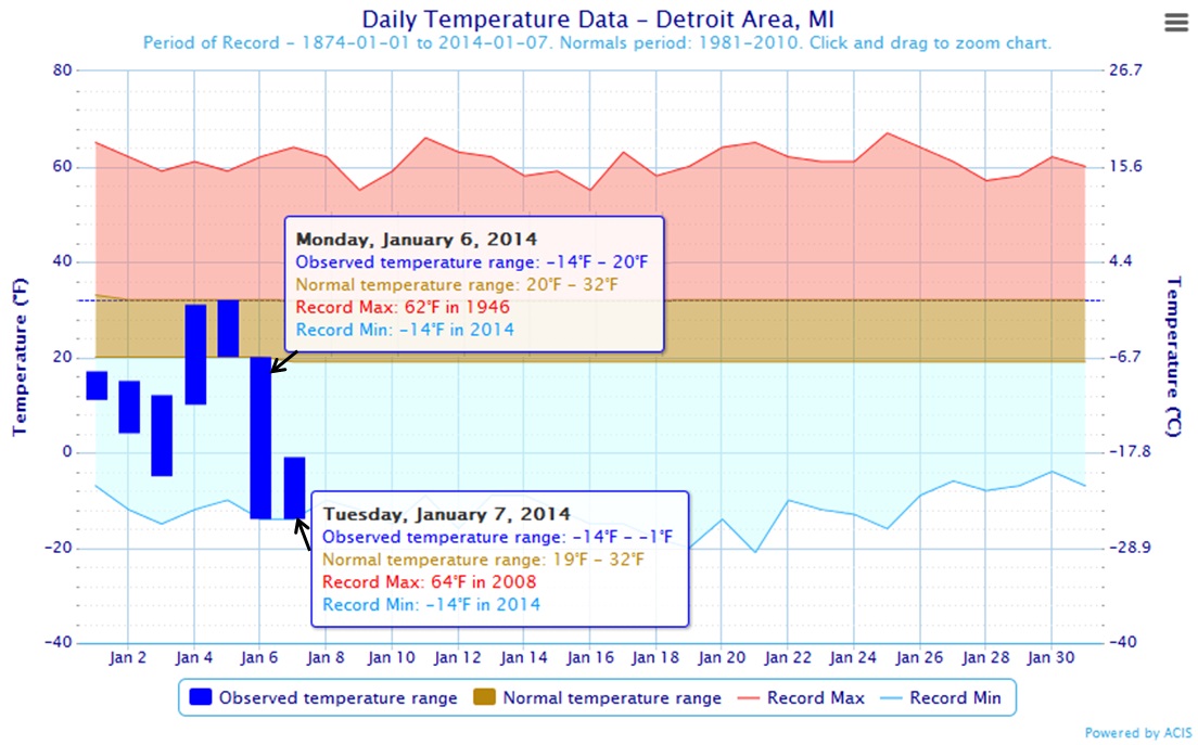
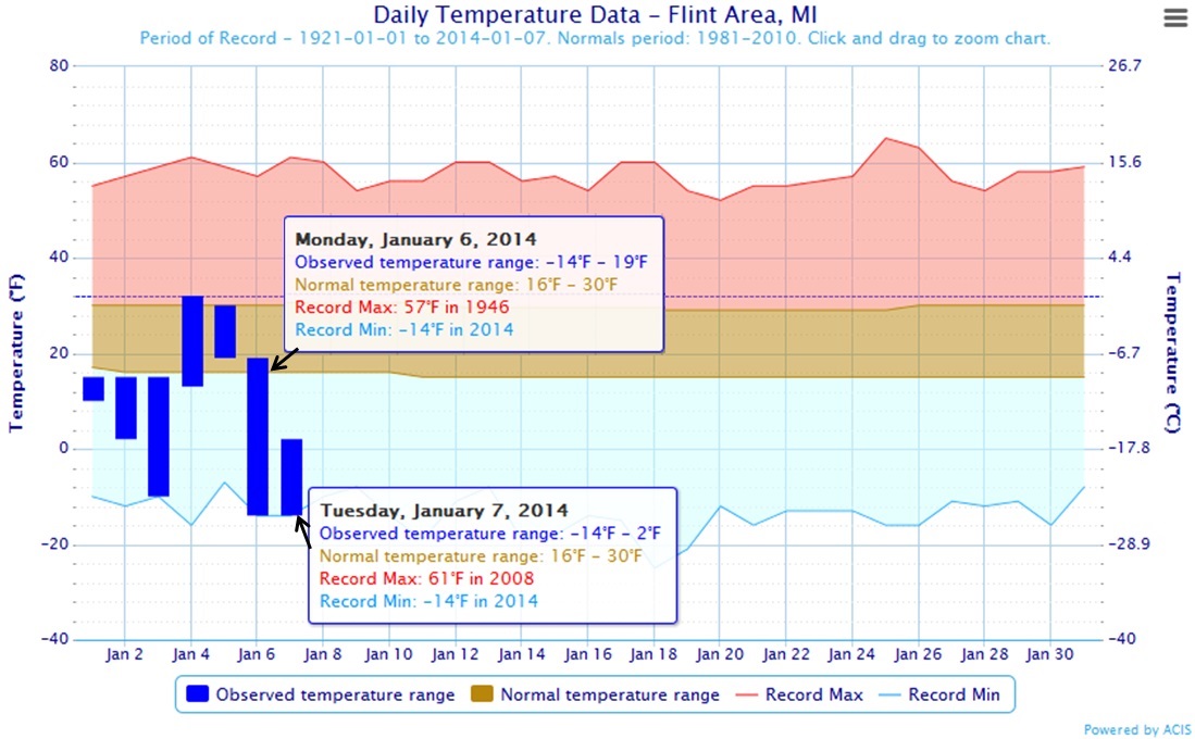
Record lows were set at both Detroit and Flint with both locations observing a low of -14 on January 6th, breaking previous records of -7 (1924) and -5 (1945), respectively.
Record lows were again set at both Detroit and Flint with both locations observing a low of -14 on January 7th, breaking previous records of -5 (1942) and -10 (1986), respectively.
Saginaw also broke a low temperature record on both January 6th and 7th, recording -9 and -11 degrees breaking the old records of -8 (1912) and -9 (1912), respectively.
All-Time Record Low Minimum Temperatures
Detroit
| Temp | Most recent occurrence |
| -24 | 12/24/1872 |
| -21 | 1/21/1984 |
| -20 | 1/19/1994 |
| -18 | 1/18/1976 |
| -16 | 2/9/1934 |
Flint
| Temp | Most recent occurrence |
| -25 | 1/18/1976 |
| -22 | 1/22/1967 |
| -21 | 1/19/1994, 1/9/2014 |
| -19 | 1/14/2009 |
| -16 |
1/25/2004 |
All-Time Record Low Maximum Temperatures
Detroit
| Temp | Most recent occurrence |
| -4 | 1/19/1994 |
| -3 | 2/9/1899 |
| -1 | 1/17/1982, 1/7/2014 |
| 0 | 1/15/1972 |
| 1 | 1/18/1994 |
Flint
| Temp | Most recent occurrence |
| -4 | 1/18/1994 |
| -3 | 1/19/1994 |
| -1 | 1/17/1982 |
| 0 | 1/7/1942 |
| 1 |
1/21/1984 |
Daily Record Low Minimum/Maximum Temperatures
Detroit
Record low max temperature was broken on January 7th, breaking the previous record of 3 degrees set in 1942.
| Date | Record Low Min (Year) | Record Low Max (Year) |
| 1/6 | -14 (2014) | 5 (1912) |
| 1/7 | -14 (2014) |
-1 (2014) |
| 1/8 | -10 (1981) | 6 (1970) |
Flint
| Date | Record Low Min (Year) | Record Low Max (Year) |
| 1/6 | -14 (2014) | 12 (1924) |
| 1/7 | -14 (2014) | 0 (1942) |
| 1/8 | -10 (1986) | 9 (1942) |
Saginaw
| Date | Record Low Min (Year) | Record Low Max (Year) |
| 1/6 | -9 (2014) | 5 (1912) |
| 1/7 | -11 (2014) | -1 (1942) |
| 1/8 | -7 (1968) | -11 (1942) |
Cooperative Observer Statistics
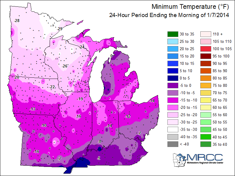 |
| Minimum temperature recorded at cooperative observer sites across the Midwest. Image courtesy of Midwestern Regional Climate Center (MRCC) |
| Many Cooperative Observer Program (COOP) sites also saw daily record low temps. To find out more about the COOP program, click here. (Based on 7am observations) | ||||||
| January 7th | ||||||
| Low Temperature | Reporting Since | |||||
| Ann Arbor (U of M) | -14 | 1849 | ||||
| Saline 4W | -23 | 1976 | ||||
| Grosse Pointe Farms | -14 | 1946 | ||||
| Richmond 4NNW | -17 | 2001 | ||||
| January 8th | ||||||
| Low Temperature | Reporting Since | |||||
| Adrian | -18 | 1870 | ||||
| Richmond 4NNW | -17 | 2001 | ||||
| Yale | -15 | 1926 | ||||
| Manchester | -15 | 1971 | ||||
| Port Huron | -14 | 1874 | ||||
| Grosse Pointe Farms | -11 | 1946 | ||||
| Flint 7W | -9 | 1948 | ||||
Midwest Snow Depth Chart (1/8/14)
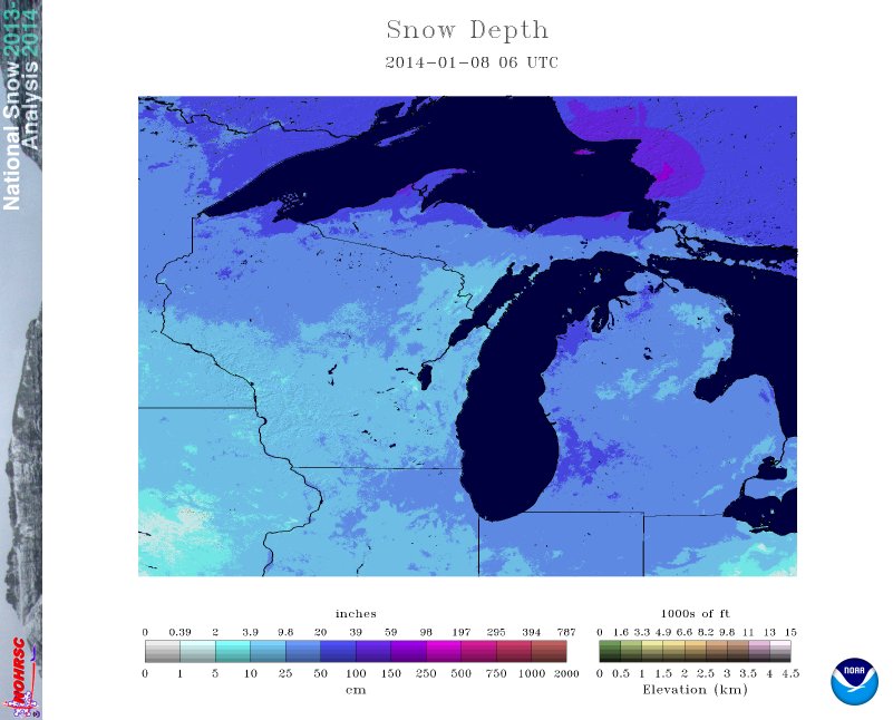
(Above photo coutesy of NOHRSC)
 |
 |
 |
| January 5 | January 6 | January 7 |
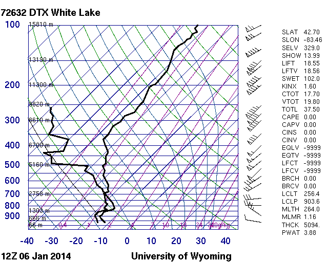
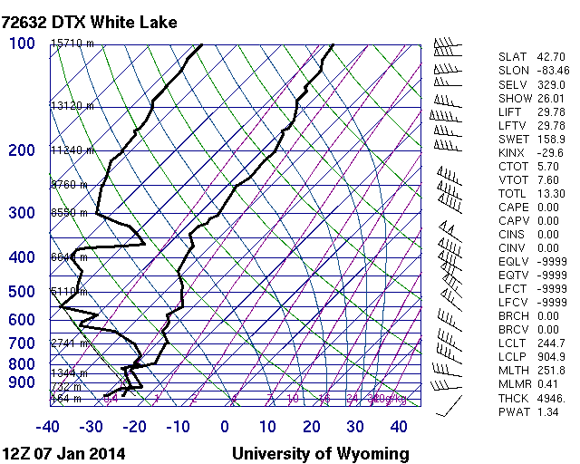
| Upper air soundings from the NWS office in White Lake, MI showing the cold air filtering into the area. The three soundings (Skew-T/Log P diagrams) correspond to 7am (12Z) January 5-7, 2014. See the following link for more information about indices. Images courtesy of the University of Wyoming | ||
| Daily temperature data showing the observed lows for the Detroit and Flint areas in graphical form. (click on thumbnail to enlarge) | |
 |
 |
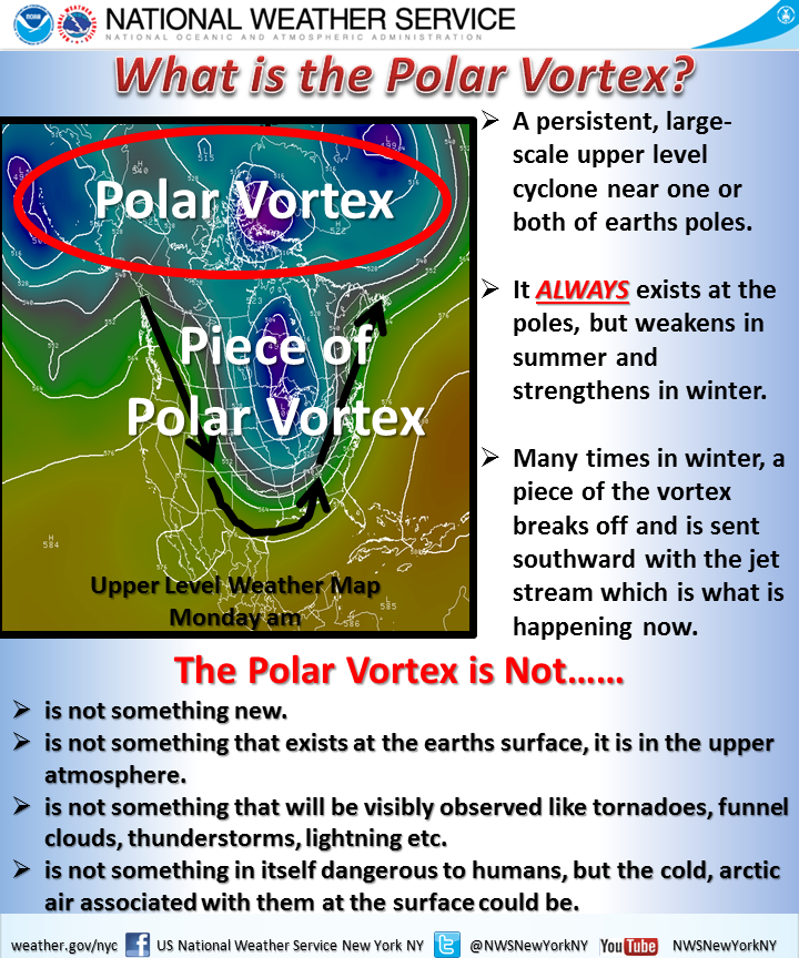
| The term polar vortex got a lot of attention during this event. The NWS office in New York put together this graphic explaining what the polar vortex is and is not. |
 |
Back to top
Additional Resources (click on links for more information)

