Overview
An early season squall line developed over Illinois on the afternoon of March 30, 2025, then tracked northeast across southern Lower Michigan during the late afternoon and evening hours. This line of storms packed a punch of severe to significant winds over much of the state with wind gusts measured between 60 and 70 mph. Pockets of locally higher gusts were also observed, including a gust of 96 mph at the Jackson County Airport. There were numerous reports of uprooted trees and property damage, and at least 35,000 customers were left without power according to local news reports. Parts of Southeast Michigan that were particularly hard hit were within Shiawassee, Genesee, Saginaw, Washtenaw, and Wayne Counties.
Radar
|
|
| Loop of NEXRAD Base Reflectivity Radar from 4:55pm to 9:00pm, March 30 2025 - courtesy Iowa Environmental Mesonet (IEM) |
Satellite & Lightning
|
|
| Loop of GOES-East Geostationary Lightning Mapper - Lightning flash extent over GeoColor from 2116 UTC March 30 2025 to 0126 UTC March 31 2025 - courtesy NOAA GOES Imagery Viewer |
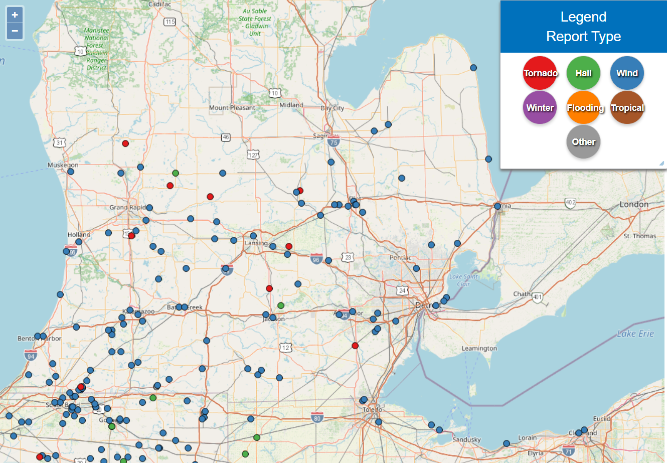
Storm Reports & Tornadoes
|
|
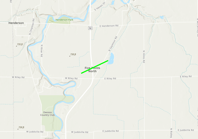
A brief tornado developed on the evening of March
30, 2025 in the New Haven Township. The tornado crossed M-52,
where a few homes sustained roof, soffit, and fascia damage.
The tornado was rated an EF-1, with estimated peak winds of 90 mph.
|
|
|
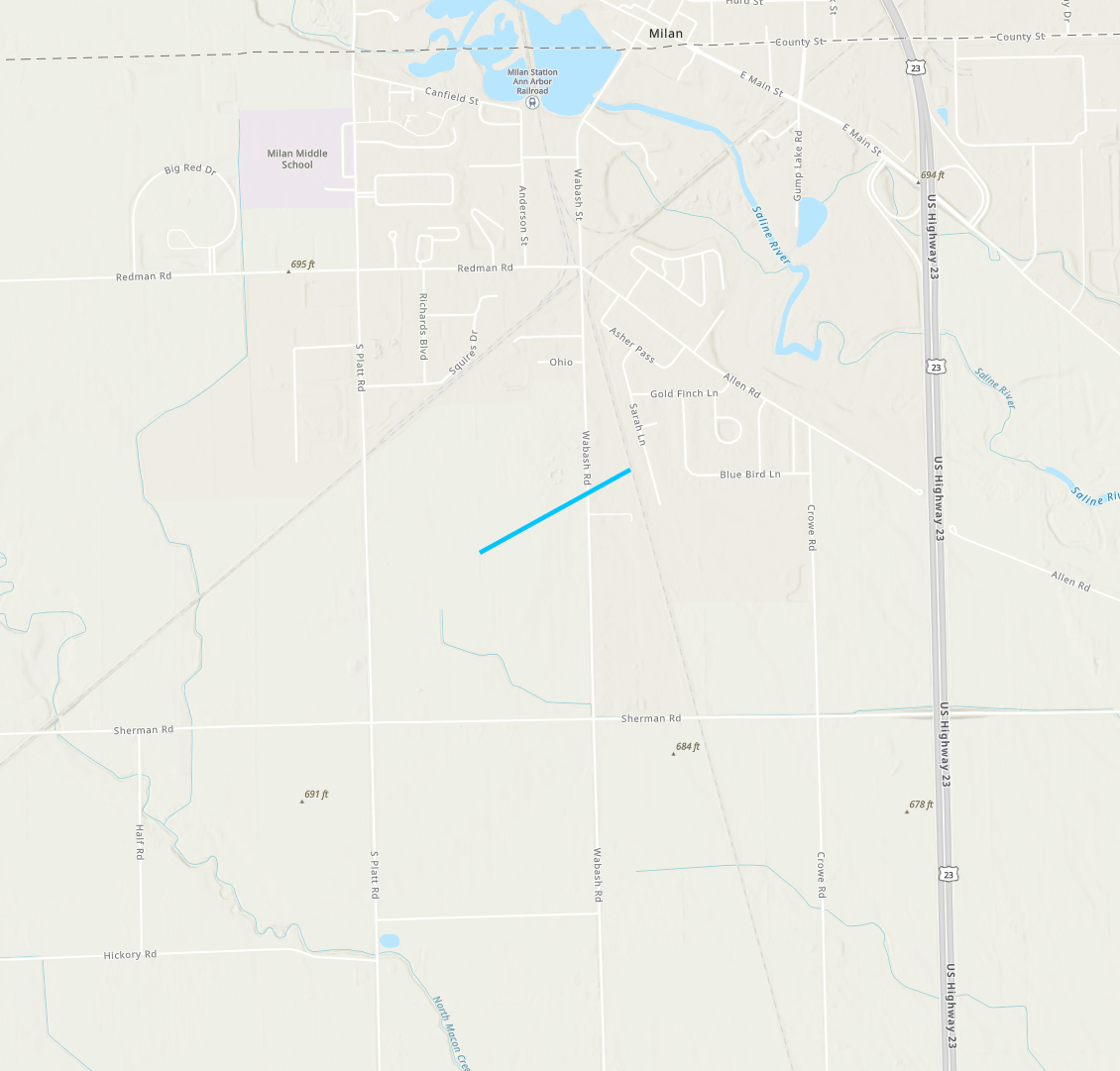
A brief tornado developed south of Milan, tracked
northeast and impacted a neighborhood along Wabash Road. A couple
of homes sustained damage to siding and lost roofing materials. A
few large tree limbs and trees were also snapped.
The tornado was rated an EF-0, with estimated peak winds of 85 mph.
|
|
|
| Lower Michigan Storm Reports for March 30, 2025 |
 |
| National Storm Reports for March 30, 2025 |
Preliminary Local Storm Report...Summary
National Weather Service Detroit/Pontiac MI
841 AM EDT Mon Mar 31 2025

..TIME...   ...EVENT...      ...CITY LOCATION...     ...LAT.LON...
..DATE...   ....MAG....      ..COUNTY LOCATION..ST.. ...SOURCE....
            ..REMARKS..

0613 PM     Tstm Wnd Dmg     Hudson                  41.86N  84.35W
03/30/2025                   Lenawee            MI   Public

            Pictures of large tree limbs down and multiple trees
            down on roads or partially uprooted.

0651 PM     Tstm Wnd Dmg     4 S Delhi Mills         42.27N  83.83W
03/30/2025                   Washtenaw          MI   Trained Spotter

            2 foot diameter tree down near Liberty and Dornoch Rds.
0651 PM Tornado 1 SSW Milan 42.07N 83.69W
03/30/2025 Monroe MI NWS Storm Survey
Delayed report. NWS has verified an EF-0
tornado from Sunday, March 30. Max sustained
winds of 85 mph.
0653 PM Tstm Wnd Gst 1 NE Howell 42.62N 83.92W
03/30/2025 E75 mph Livingston MI NWS Employee
0654 PM Tstm Wnd Gst 2 NE Ann Arbor 42.29N 83.71W
03/30/2025 E65 mph Washtenaw MI Trained Spotter
Estimated wind gusts with pea to half inch sized hail
0657 PM Tstm Wnd Dmg 2 S Henderson 43.06N 84.20W
03/30/2025 Shiawassee MI Public
Tree uprooted and street sign bent
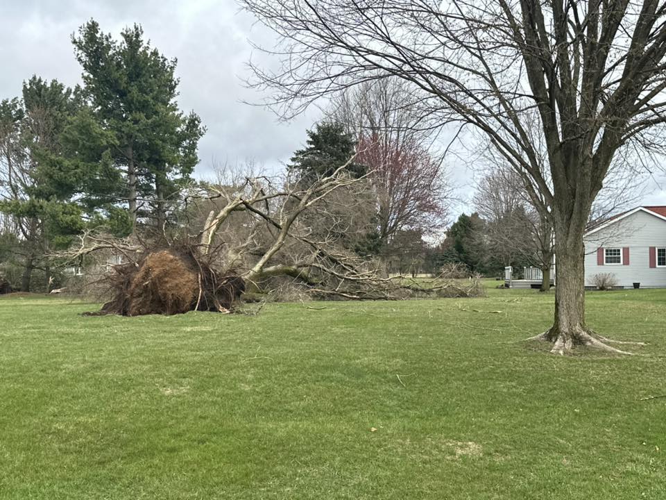
0657 PM Tstm Wnd Dmg 1 SE Owosso 42.99N 84.16W
03/30/2025 Shiawassee MI Public
Trees down including one partially uprooted taking the
sidewalk with it on Broadway Av.
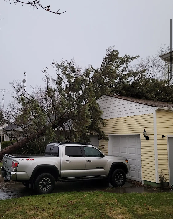
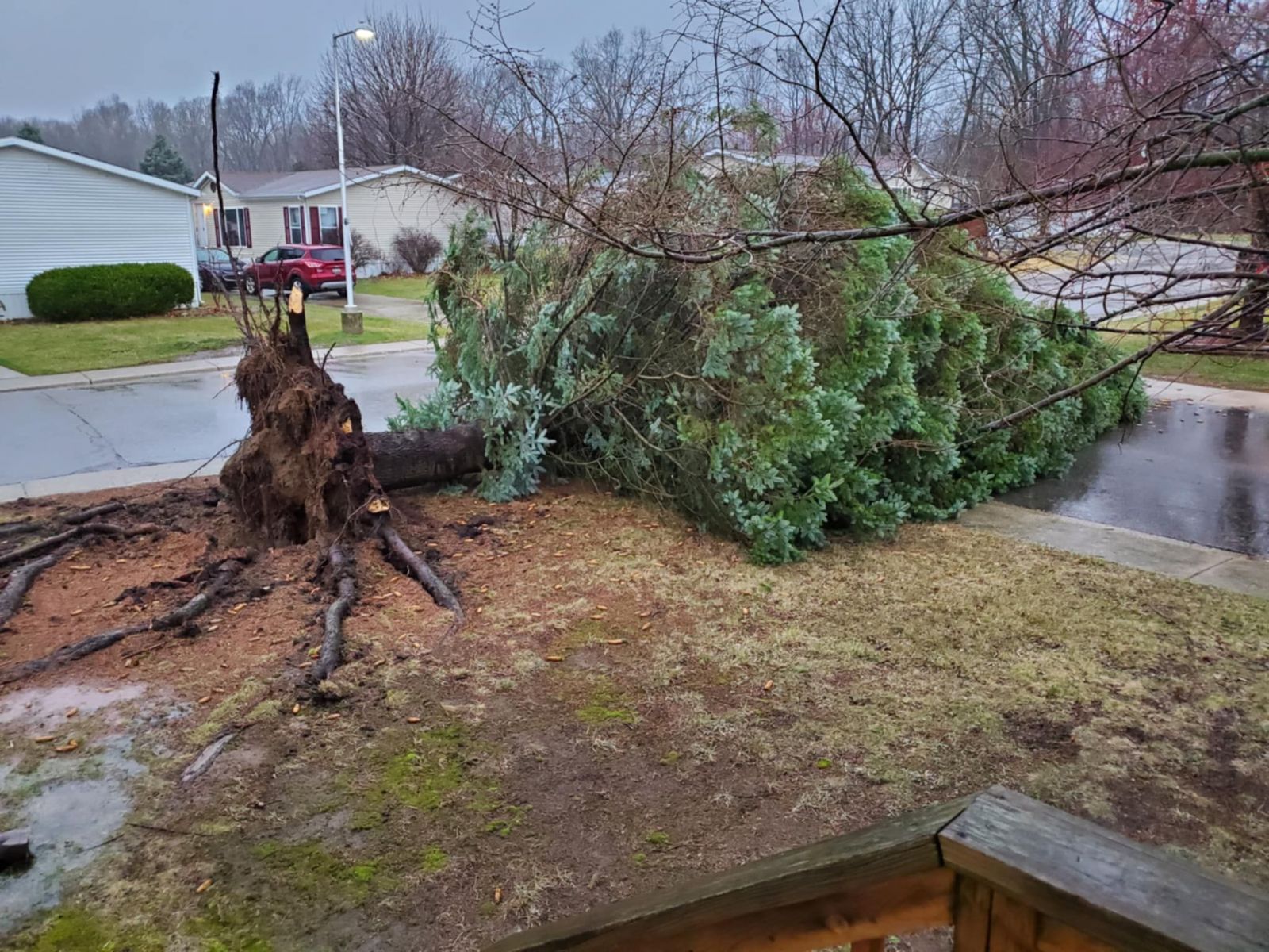
0659 PM Tstm Wnd Dmg Durand 42.91N 83.99W
03/30/2025 Shiawassee MI Public
Large pine uprooted and down on a garage
0700 PM     Tornado          2 ESE Henderson         43.07N 84.17W
03/30/2025                   Shiawassee         MI   NWS Storm Survey

            Delayed report. NWS has verified an EF-1
            tornado from Sunday, March 30. Max sustained
            winds of 90 mph.

0705 PM     Tstm Wnd Dmg     2 W Swartz Creek        42.98N  83.87W
03/30/2025                   Genesee            MI   Public

            Large pine snapped and partially uprooted

0705 PM     Tstm Wnd Dmg     2 NW Sumpter Township   42.16N  83.51W
03/30/2025                   Wayne              MI   Public

            Video of large tree uprooted

0707 PM     Tstm Wnd Gst     Willow Run Airport      42.24N  83.53W
03/30/2025  M63 mph          Wayne              MI   ASOS

0707 PM     Tstm Wnd Dmg     2 S Canton              42.28N  83.49W
03/30/2025                   Wayne              MI   Emergency Mngr

            Emergency Management reports mobile homes damaged in
            the Holiday Estates mobile home park.

0707 PM     Tstm Wnd Dmg     1 N Swartz Creek        42.98N  83.83W
03/30/2025                   Genesee            MI   Trained Spotter

            Spotter reported trees uprooted near the intersection
            of Morrish adn Lennon Roads and on Van Vleet Road.
0707 PM     Tstm Wnd Dmg     2 S Belleville          42.18N 83.49W
03/30/2025                   Wayne              MI   Emergency Mngr

            Delayed report. Numerous large trees
            uprooted, all were blown down in the same
            direction. One tree fell on a home and
            caused significant damage. A nearby large
            shed or small barn was also destroyed.

0709 PM     Tstm Wnd Gst     Flint Bishop Intl Airpo 42.97N  83.75W
03/30/2025  M61 mph          Genesee            MI   ASOS

0710 PM     Tstm Wnd Gst     3 S Flint               42.98N  83.69W
03/30/2025  M70 mph          Genesee            MI   Mesonet

            Measured on private weather station

0711 PM     Tstm Wnd Dmg     2 S Flint               43.00N  83.70W
03/30/2025                   Genesee            MI   Public

            Pictures of damaged fencing, shredded netting, and
            snapped poles at Powers Catholic High School baseball
            fields

0712 PM     Tstm Wnd Gst     3 S Flint               42.98N  83.68W
03/30/2025  M67 mph          Genesee            MI   Broadcast Media

            Also reported quarter sized hail

0717 PM     Tstm Wnd Gst     Detroit Metro Intl Airp 42.23N  83.33W
03/30/2025  M63 mph          Wayne              MI   ASOS

0718 PM     Tstm Wnd Dmg     1 N Burt                43.25N  83.90W
03/30/2025                   Saginaw            MI   911 Call Center

            Dispatch reports multiple trees down on houses in the
            southern part of the county.

0730 PM     Tstm Wnd Dmg     1 SW Troy               42.57N  83.15W
03/30/2025                   Oakland            MI   Public

            Tree down on wires near Livernois and Wendelton roads

0733 PM     Tstm Wnd Dmg     2 W Five Lakes          43.15N  83.28W
03/30/2025                   Lapeer             MI   911 Call Center

            Dispatch reports trees and wires down throughout area

0738 PM     Tstm Wnd Dmg     1 E Washington          42.72N  83.02W
03/30/2025                   Macomb             MI   911 Call Center

            Dispatch reports trees down near Jewell and 27 mile
            road

0744 PM     Marine Tstm Wind Peche Island Light      42.36N  82.91W
03/30/2025  M46 mph          Wayne              MI   Mesonet

0745 PM     Marine Tstm Wind 3 E Detroit             42.33N  82.98W
03/30/2025  M44 mph          LCZ423             MI   Mesonet

            Measured at Belle Isle

0747 PM     Tstm Wnd Dmg     Watrousville            43.45N  83.52W
03/30/2025                   Tuscola            MI   Fire Dept/Rescue

            Power lines down and roof blown off.

0749 PM     Tstm Wnd Dmg     Caro                    43.49N  83.40W
03/30/2025                   Tuscola            MI   Fire Dept/Rescue

            Tree fell on mobile home.

0752 PM     Tstm Wnd Dmg     New Haven               42.73N  82.79W
03/30/2025                   Macomb             MI   911 Call Center

            Dispatch reports trees down

0755 PM     Marine Tstm Wind 1 E Grosse Point Club H 42.38N  82.89W
03/30/2025  M52 mph          LCZ460             MI   Mesonet

            Measured at Grosse Pointe Yacht Club

0815 PM     Tstm Wnd Dmg     2 NE South Park         42.97N  82.44W
03/30/2025                   St. Clair          MI   Trained Spotter

            2 foot diameter tree down on Griswold and Oak roads.

0819 PM     Marine Tstm Wind Lexington Harbor        43.27N  82.52W
03/30/2025  M40 mph          Sanilac            MI   Mesonet

0830 PM     Marine Tstm Wind Harbor Beach            43.85N  82.65W
03/30/2025  M44 mph          Huron              MI   Mesonet
&&
Photos & Video
 |
 |
 |
 |
| Hudson, MI (Courtesy of Ryan Jake Jakubowski) |
Hudson, MI (Courtesy of Ryan Jake Jakubowski) |
Henderson, MI (Courtesy of Andy Robinson) |
Henderson, MI (Courtesy of Andy Robinson) |
 |
 |
 |
 |
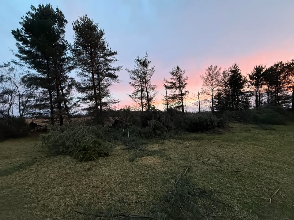
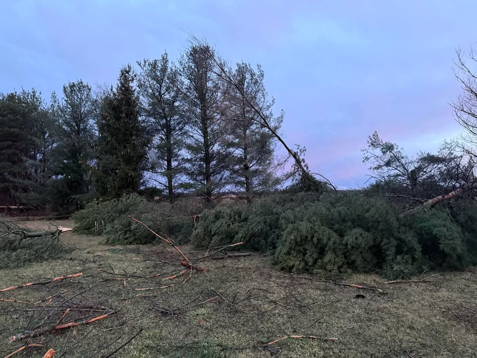
| Henderson, MI (Courtesy of Andy Robinson) |
Swartz Creek, MI (Courtesy of Ben Stanley) |
Swartz Creek, MI (Courtesy of Ben Stanley) |
Durand, MI (Facebook/NWS) |
 |
 |
 |
 |
| Durand, MI (Facebook/NWS) |
Gaines Township, MI (Courtesy of Mat Bazlk) |
Hamburg, MI (Courtesy of Judy Kee) |
Tecumseh, MI (Courtesy of Joe Drogowski) |
 |
 |
 |
 |
| Owosso, MI (Courtesy of Hannah via X) |
Owosso, MI (Courtesy of Hannah via X) |
Flint, MI (Courtesy of @miwxchaser)) |
Otter Lake, MI (Courtesy of Danny James) |
 |
 |
||
| Marlette, MI (Courtesy of Daniel Klatzke) |
Brighton, MI (Courtesy of Brent Trewhella) |
Environment
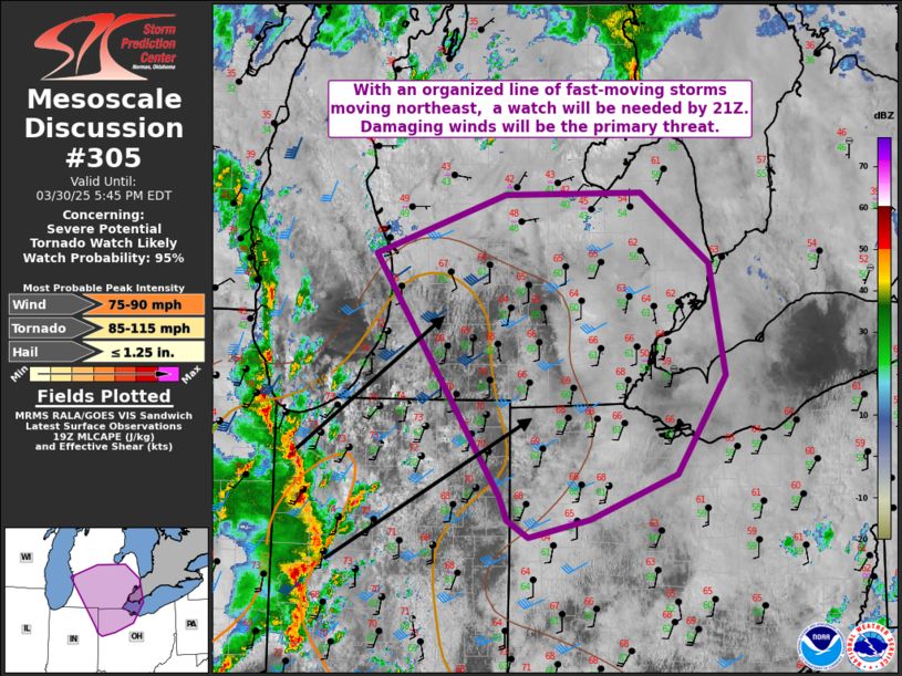
Low pressure strengthened as it tracked northeast from the Midwest into central Lower Michigan during the afternoon and evening hours. This sent a stationary front northward as a warm front and allowed very mild and humid air to advect into the region from the south. Afternoon temperatures reached the upper 60s with dew points in the lower 60s. This was sufficient for MLCAPE of 500 to 1000 J/kg. Meanwhile, a 70+ kt upper jet streak preceding a negatively-tilted upper trough provided ample bulk wind shear for storm organization and large scale ascent to provide a favorable environment for downstream propagation of the mesoscale convective system across Lower Michigan. As the system progressed across Southeast Michigan, it gradually began to outpace the available instability which caused it to weaken with eastward extent.
 |
 |
 |
| Figure 1: WPC Surface Analysis, valid 12 UTC March 30, 2025 | Figure 2: WPC Surface Analysis, valid 18 UTC March 30, 2025 | Figure 3: WPC Surface Analysis, valid 00 UTC March 31, 2025 |
 |
 |
 |
| Figure 4: Effective bulk wind shear, valid 22 UTC March 30, 2025 | Figure 5: Mixed-layer CAPE, valid 22 UTC March 30, 2025 | Figure 6: 3-hour mixed-layer CAPE change, valid 22 UTC March 30, 2025 |
 |
 |
 |
| Figure 7: DTX Sounding, valid 12 UTC March 30, 2025 | Figure 8: DTX Sounding, valid 18 UTC March 30, 2025 | Figure 9: DTX Sounding, valid 00 UTC March 31, 2025 |
 |
 |
 |
 |
| Figure 10: SPC Categorical Outlook, valid 1630 UTC March 30 2025 | Figure 11: SPC Probabilistic Damaging Wind Outlook, valid 1630 UTC March 30 2025 | Figure 12: SPC Probabilistic Tornado Outlook, valid 1630 UTC March 30 2025 | Figure 13: SPC Probabilistic Hail Outlook, valid 1630 UTC March 30 2025 |
 |
 |
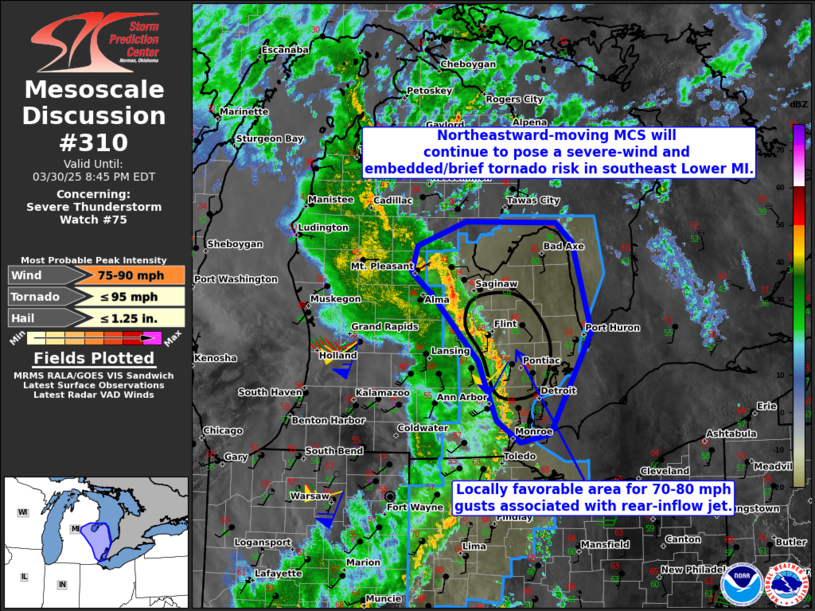 |
| Figure 14: SPC Mesoscale Discussion #305, valid 1949 UTC March 30 2025 | Figure 15: Severe Thunderstorm Watch #75, valid 2110 UTC March 30 2025 | Figure 16: SPC Mesoscale Discussion #310, valid 2312 UTC March 30 2025 |
 |
Media use of NWS Web News Stories is encouraged! Please acknowledge the NWS as the source of any news information accessed from this site. |
|