Overview
|
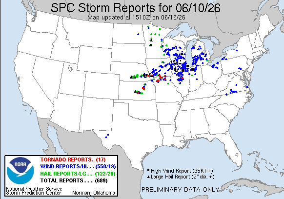
On June 10th, daytime heating pushed temperatures into the upper 80s and lower 90s, combining with surging humidity to drive heat indices near 100°F and create a highly unstable environment with MLCAPE values reaching 2,500 J/kg. Weak low-level convergence initially triggered severe storms over Wayne County, which dropped 1 to 1.25-inch hail across Dearborn and Dearborn Heights. Later in the evening, a destructive Midwestern squall line tracked into southern Lower Michigan, though it steadily weakened as it moved through Southeast Michigan before completely clearing the state by midnight. While the broader system left over 85,000 customers without power statewide, wind damage, downed trees, and power outages within Southeast Michigan remained isolated to scattered, impacting communities primarily along and west of U.S. 23. |
Radar
 |
||
|
Storm Reports
Preliminary Local Storm Report...Summary
..TIME...   ...EVENT...      ...CITY LOCATION...     ...LAT.LON...
..DATE...   ....MAG....      ..COUNTY LOCATION..ST.. ...SOURCE....
            ..REMARKS..

0640 PM     Hail             Dearborn                42.31N  83.21W
06/10/2026  M1.00 inch       Wayne              MI   Trained Spotter

            Multiple reports of 1 inch hail in Dearborn.

0641 PM     Hail             Dearborn Heights        42.34N  83.27W
06/10/2026  M1.25 inch       Wayne              MI   Trained Spotter

            Mutiple reports of hail between 1 and 1.25 inches.

0735 PM     Marine Tstm Wind 2 E Detroit             42.34N  83.00W
06/10/2026  E45 mph          LCZ423             MI   Broadcast Media

            Seven small sailboats were overturned by thunderstorms
            winds in the Detroit River near Belle Isle. At least 20
            people were thrown into the water, but no serious
            injuries were reported. Detroit Fire Department rescued
            most of the victims, including 12 who were pulled
            directly from the water.

0821 PM     Tstm Wnd Dmg     Laingsburg              42.89N  84.35W
06/10/2026                   Shiawassee         MI   Emergency Mngr

            tree down across the road by Laingsburg high school

0836 PM     Tstm Wnd Dmg     4 SW Midland            43.58N  84.29W
06/10/2026                   Midland            MI   Trained Spotter

            several large tree limbs down

0837 PM     Tstm Wnd Dmg     1 SE Munger             43.51N  83.76W
06/10/2026                   Bay                MI   Fire Dept/Rescue

            Straight-line winds knocked down over a dozen trees and
            power lines, starting near the intersection of Brown and
            Farley Roads and extending northeast to the Tuscola
            County border.

0845 PM     Tstm Wnd Dmg     Freeland                43.52N  84.12W
06/10/2026                   Saginaw            MI   Public

            Large tree reported downed in Freeland along with
            reports of power outages in the area.

0845 PM     Tstm Wnd Dmg     Midland                 43.62N  84.23W
06/10/2026                   Midland            MI   911 Call Center

            Dozens of trees downed, particularly in Larkin and
            Midland Townships.

0846 PM     Tstm Wnd Dmg     3 W Auburn              43.60N  84.13W
06/10/2026                   Bay                MI   Emergency Mngr

            Scattered trees and wires reported downed across the
            entire county.

0846 PM     Tstm Wnd Dmg     3 W Fowlerville         42.66N  84.14W
06/10/2026                   Livingston         MI   Fire Dept/Rescue

            A tree was blown down onto Wheeler Road.

0848 PM     Tstm Wnd Dmg     Cement City             42.07N  84.33W
06/10/2026                   Lenawee            MI   911 Call Center

            A tree was blown down onto Woodstock Street near Lewis
            Road.

0853 PM     Tstm Wnd Dmg     Saginaw                 43.42N  83.95W
06/10/2026                   Saginaw            MI   Emergency Mngr

            A few trees reported down in Saginaw Township.

0900 PM     Marine Tstm Wind Killarney Beach         43.69N  83.92W
06/10/2026  M39 mph          Bay                MI   C-Man Station

0912 PM     Tstm Wnd Dmg     Rogersville             43.12N  83.57W
06/10/2026                   Genesee            MI   Trained Spotter

            Tree down across part of Mount Morris Rd near Irish Rd.

0914 PM     Tstm Wnd Dmg     3 SW Columbiaville      43.13N  83.46W
06/10/2026                   Lapeer             MI   Trained Spotter

            Tree down across part of Mount Morris Rd at Washburn Rd

0930 PM     Tstm Wnd Gst     Sand Point              43.91N  83.36W
06/10/2026  M52 mph          Huron              MI   C-Man Station

0938 PM     Marine Tstm Wind Caseville Light         43.95N  83.29W
06/10/2026  M46 mph          Huron              MI   C-Man Station

0943 PM     Marine Tstm Wind 11 NW Sand Point        44.02N  83.54W
06/10/2026  M51 mph          LHZ421             MI   C-Man Station

            Measured at Gravelly Shoal Light.

0943 PM     Marine Tstm Wind Caseville Light         43.95N  83.29W
06/10/2026  M50 mph          Huron              MI   C-Man Station

0945 PM     Tstm Wnd Dmg     2 SE East Dayton        43.39N  83.26W
06/10/2026                   Tuscola            MI   911 Call Center

            Large tree blown down on Plain Road, north of Shay Lake
            Road.

0947 PM     Tstm Wnd Dmg     Orchard Lake            42.58N  83.38W
06/10/2026                   Oakland            MI   Law Enforcement

            Road closed at Old Orchard Trail and West Shore Dr due
            to downed tree on roadway.


&&
SPC Storm Reports
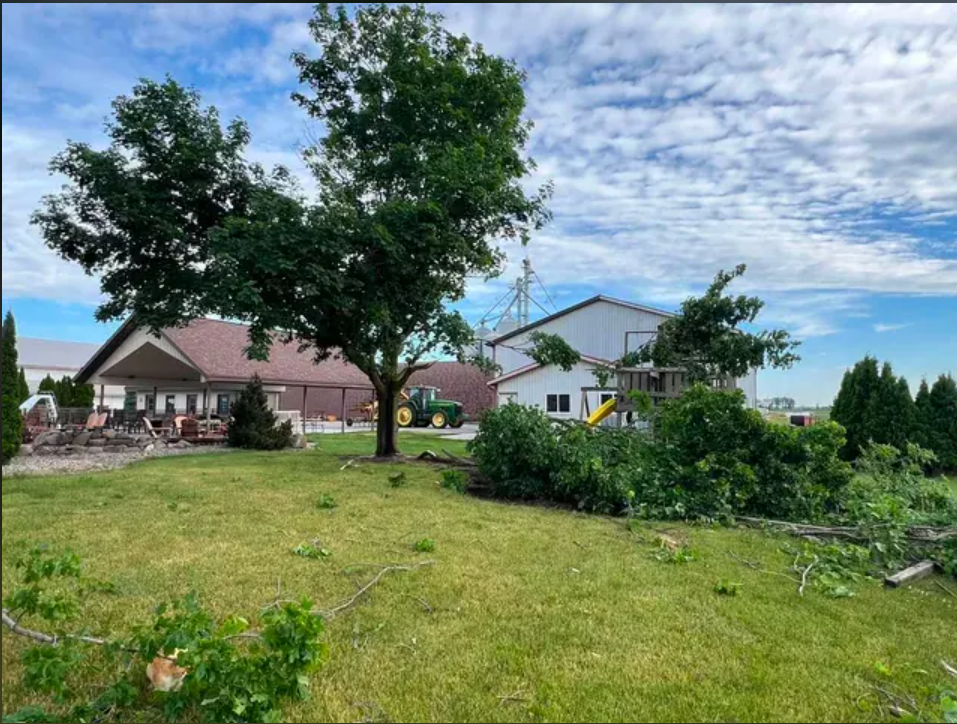
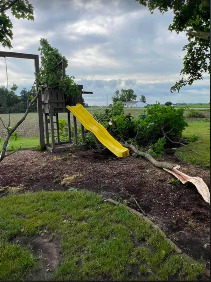
Photos & Video
Marginal Wind Damage and Large Hail.
 |
 |
 |
| Munger Damage |
Munger Damage |
Dearborn Hail |
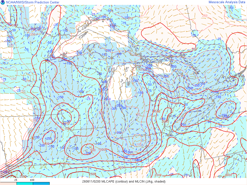
Environment
SPC Outlooks.
 |
 |
 |
| Figure 1: Severe Outlook | Figure 2: Damaging Winds Outlook | Figure 3: Hail Outlook |
Environment summary.
 |
.gif) |
 |
| Figure 4: 22z June 10 Hail Parameters | Figure 5: 22z June 10 Surface Pressure | Figure 6: 00z June 11 DTX Sounding |
 |
 |
 |
| Figure 7: 00z June 11 MLcape/cin | Figure 8: 02z June 11 MLcape/cin | Figure 9: 1z June 11 Effective Shear |
 |
Media use of NWS Web News Stories is encouraged! Please acknowledge the NWS as the source of any news information accessed from this site. |
|

