Overview
|
Multiple rounds of thunderstorms impacted portions of Southeast Michigan on June 18, 2025. The first round consisted of sub-severe pop-up thunderstorms during the morning hours. These produced pockets of heavy downpours but otherwise brought some relief to areas that had seen relatively dry conditions in recent days. Showers expanded in coverage across the southern part of the state by late morning to early afternoon as a disturbance aloft ushered in a more organized cluster of thunderstorms. These were also sub-severe, but the presence of environmental vorticity caused a weak tornado to quickly develop as several outflow boundaries collided near Fraser in Macomb County. These storms also produced torrential downpours. Nearly stationary storms dumped 3 to 5 inches of rain over a localized area in central Macomb County where flash flooding occurred early in the afternoon, closing roads and leading to several water rescues. A lull in activity occurred during the mid afternoon before a third round of thunderstorms arrived in the evening as a low pressure system approached from Indiana. This line of storms prompted a Severe Thunderstorm Watch and several Severe Thunderstorm Warnings with isolated occurrences of wind damage across southern parts of the state. Local Media
|
Tornadoes
|
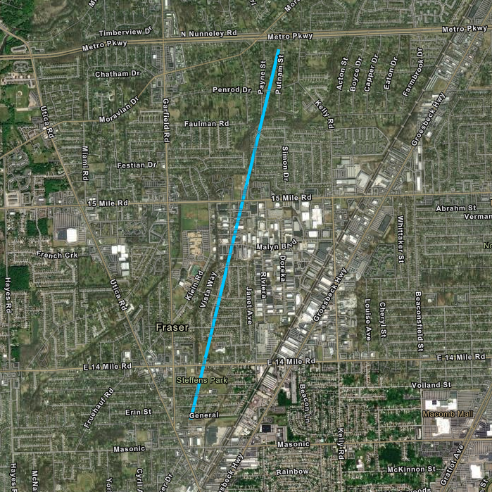
Tornado - Fraser, MI
Track Map

|
||||||||||||||||
The Enhanced Fujita (EF) Scale classifies tornadoes into the following categories:
| EF0 Weak 65-85 mph |
EF1 Moderate 86-110 mph |
EF2 Significant 111-135 mph |
EF3 Severe 136-165 mph |
EF4 Extreme 166-200 mph |
EF5 Catastrophic 200+ mph |
 |
|||||
|
|
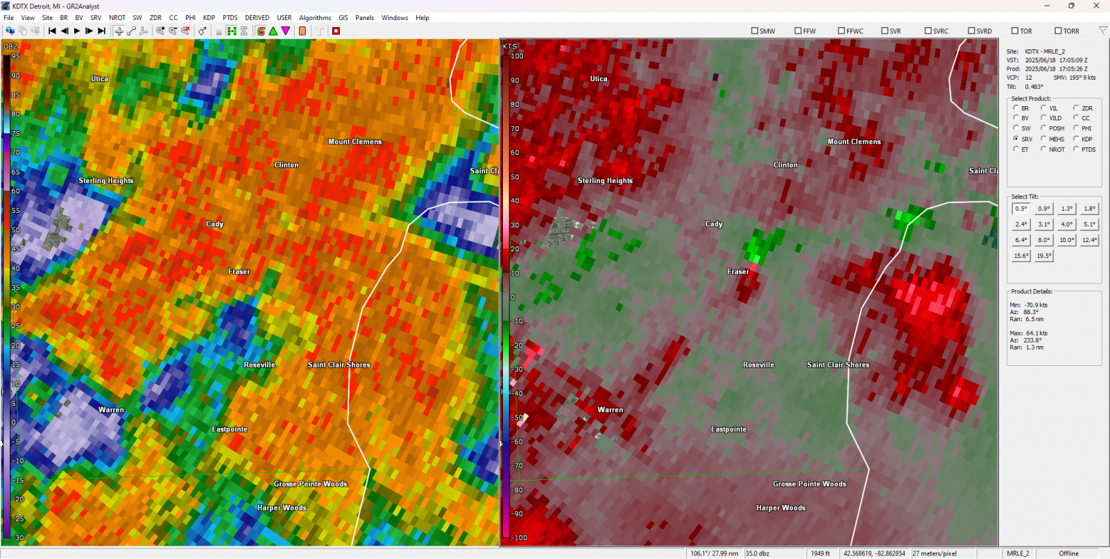
| KDTX Base Reflectivity and Storm Relative Velocity Radar valid 1:05pm, June 18, 2025 - courtesy GR2Analyst |
Radar
|
|
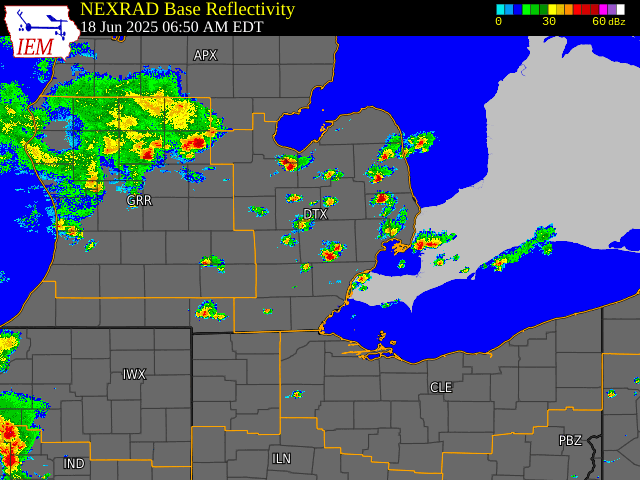
| Loop of NEXRAD Base Reflectivity Radar from 6:50am to 3:00pm, June 18, 2025 - courtesy Iowa Environmental Mesonet (IEM) |
|
|
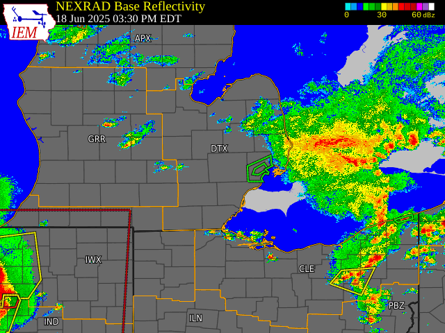
| Loop of NEXRAD Base Reflectivity Radar from 3:30pm to 10:00pm, June 18, 2025 - courtesy Iowa Environmental Mesonet (IEM) |
Satellite & Lightning
|
|
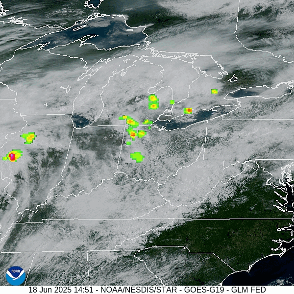
| Loop of GOES-East Geostationary Lightning Mapper - Lightning flash extent over GeoColor from 1456 UTC to 1856 UTC June 18, 2025 - courtesy NOAA GOES Imagery Viewer |
|
|
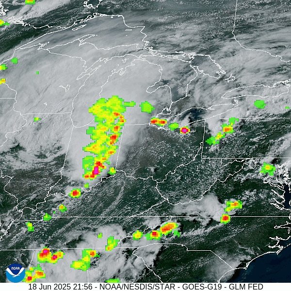
| Loop of GOES-East Geostationary Lightning Mapper - Lightning flash extent over GeoColor from 2201 UTC June 18 to 0156 UTC June 19, 2025 - courtesy NOAA GOES Imagery Viewer |
Storm Reports
|
|
| Southeast Michigan Storm Reports for June 18, 2025 - courtesy Iowa Environmental Mesonet (IEM) Numbers denote measured wind gusts (mph) |
 |
| National Storm Reports for June 18, 2025 |
Preliminary Local Storm Report...Summary
National Weather Service Detroit/Pontiac MI
1158 AM EDT Thu Jun 19 2025

..TIME...   ...EVENT...      ...CITY LOCATION...     ...LAT.LON...
..DATE...   ....MAG....      ..COUNTY LOCATION..ST.. ...SOURCE....
            ..REMARKS..

0105 PM     Tornado          1 NE Fraser             42.55N  82.94W
06/18/2025                   Macomb             MI   Broadcast Media

            Probable tornado with downed large limbs near Kelly Rd
            between 14 and 15 Mile Rd.

0128 PM     Flood            1 NW Cady               42.57N  82.97W
06/18/2025                   Macomb             MI   Trained Spotter

            Curb to curb flooding on Hayes Rd between 19 Mile and
            Utica Rd, and Utica Rd between Hayes Rd and Metro Pkwy.

0141 PM     Flood            1 SW Waldenburg         42.64N  82.95W
06/18/2025                   Macomb             MI   Trained Spotter

            Curb to curb flooding on residential streets near 21
            Mile and Garfield Rd.

0141 PM     Flash Flood      2 N Clinton Township    42.62N  82.92W
06/18/2025                   Macomb             MI   911 Call Center

            Water rescue reported at Dunham Rd and Heydenreich Rd.

0145 PM     Flood            1 N Mount Clemens       42.61N  82.88W
06/18/2025                   Macomb             MI   911 Call Center

            Curb to curb flooding at North Ave and Elizabeth Rd in
            Mt. Clemens.

0206 PM     Flash Flood      2 NW Clinton Township   42.61N  82.95W
06/18/2025                   Macomb             MI   Public

            Social media photo of vehicles in wheel well deep water
            on Garfield Rd near 19 Mile Rd.

0215 PM     Flood            1 NE Chesterfield       42.67N  82.83W
06/18/2025                   Macomb             MI   Amateur Radio

            Gratiot Rd impassable at 23 Mile Rd due to flooding.

0707 PM     Tstm Wnd Dmg     3 SE Tipton             42.00N  84.02W
06/18/2025                   Lenawee            MI   911 Call Center

            Large limbs down over a few area roads especially in
            the north central part of the county.

0715 PM     Tstm Wnd Dmg     3 W Chilson             42.51N  83.92W
06/18/2025                   Livingston         MI   911 Call Center

            Trees reported down on E Schafer Rd between Pinckney
            and Farley Rds.

0754 PM     Tstm Wnd Dmg     Monroe                  41.92N  83.39W
06/18/2025                   Monroe             MI   911 Call Center

            A few trees reported down.

0804 PM     Tstm Wnd Dmg     1 SE Stony Point        41.94N  83.26W
06/18/2025                   LEZ444             MI   Public

            Large tree down in Stony Point. Photo via social media.

0804 PM     Tstm Wnd Dmg     2 SE Belleville         42.18N  83.45W
06/18/2025                   Wayne              MI   Public

            Large tree uprooted on Riggs Rd in Belleville. Photo
            via social media.

0809 PM     Tstm Wnd Dmg     2 W Romulus             42.23N  83.41W
06/18/2025                   Wayne              MI   Public

            Trees down near Ozga St and Menton St in Romulus.
            Videos via social media.

0810 PM     Marine Tstm Wind Stony Point             41.95N  83.27W
06/18/2025  M42 mph          Monroe             MI   C-Man Station

0811 PM     Marine Tstm Wind 2 N Estral Beach        42.02N  83.25W
06/18/2025  M44 mph          Monroe             MI   Public

0814 PM     Marine Tstm Wind Detroit River Light     42.00N  83.14W
06/18/2025  M58 mph          LEZ444             MI   C-Man Station

0828 PM     Tstm Wnd Dmg     Dearborn                42.31N  83.21W
06/18/2025                   Wayne              MI   Public

            Large tree down in Dearborn. Photo via social media.


&&
Rainfall Reports
|
|
| MRMS Q3 Multi-Sensor 24 Hour Rainfall Estimates, valid 1200 UTC June 19, 2025 |
|
|
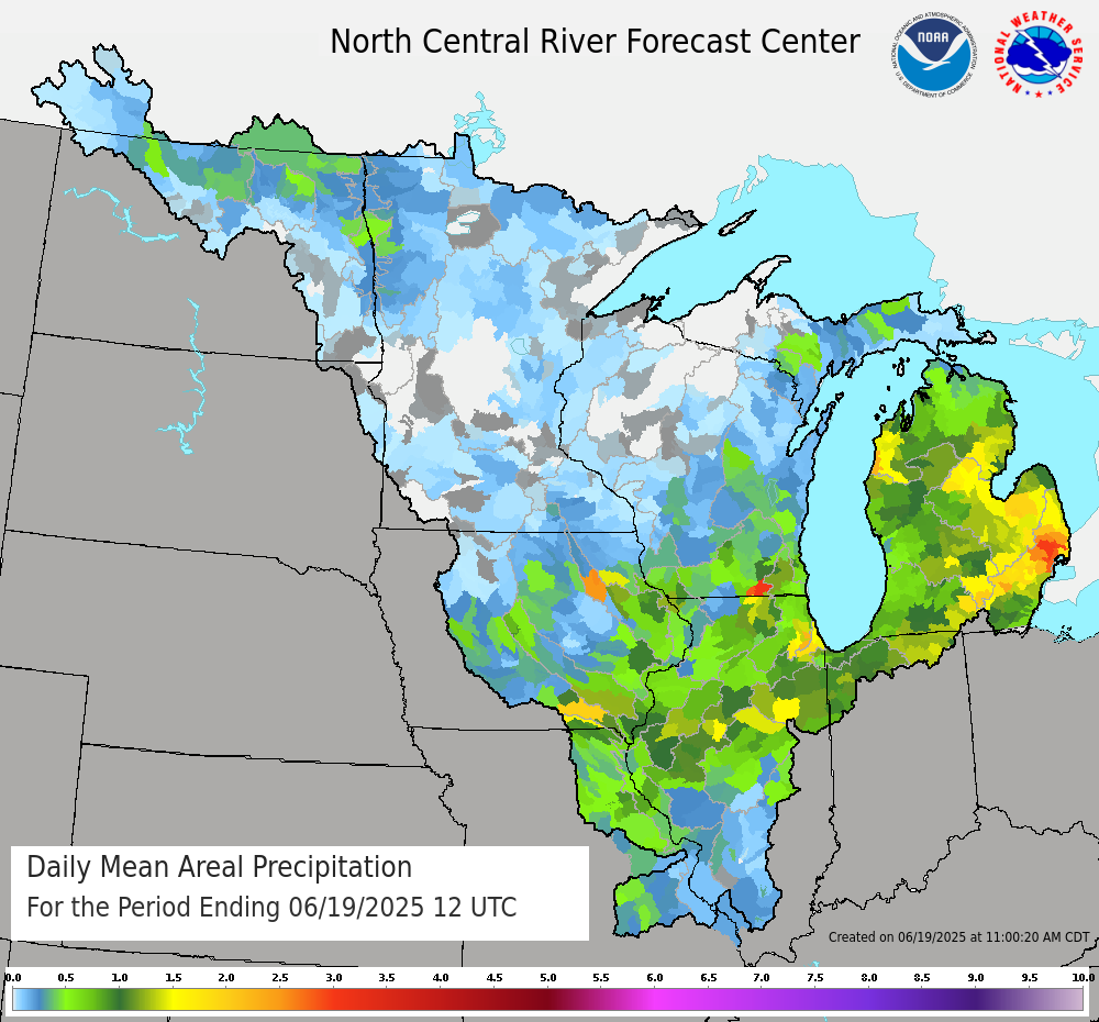
| North Central River Forecast Center Daily Mean Areal Precipitation, valid 1200 UTC June 19, 2025 |
Public Information Statement
National Weather Service Detroit/Pontiac MI
1204 PM EDT Thu Jun 19 2025

...PRECIPITATION REPORTS...

Location                     Amount    Time/Date       Lat/Lon

...Michigan...

...Bay County...
Bay City 4.4 N               2.03 in   0830 AM 06/19   43.65N/83.90W
3.3 E Auburn                 1.72 in   0630 AM 06/19   43.63N/84.02W
Bay City 0.9 NE              1.70 in   0600 AM 06/19   43.60N/83.87W
Essexville 2.0 ESE           1.26 in   0700 AM 06/19   43.60N/83.81W

...Genesee County...
Fenton 1.1 S                 1.76 in   0700 AM 06/19   42.78N/83.71W
Goodrich                     1.57 in   0730 AM 06/19   42.92N/83.51W
Grand Blanc 2.9 SE           1.43 in   0700 AM 06/19   42.89N/83.59W
3.4 SE Genesee               1.37 in   0700 AM 06/19   43.07N/83.59W
Flint 2.4 WSW                1.26 in   0830 AM 06/19   43.00N/83.73W
Davison 3.4 NNW              1.24 in   0800 AM 06/19   43.08N/83.55W
Flint                        1.21 in   0853 AM 06/19   42.97N/83.75W
Linden                       1.20 in   0700 AM 06/19   42.81N/83.80W

...Huron County...
Bad Axe                      1.28 in   0625 AM 06/19   43.82N/83.00W
Bay Port 3.2 SSW             1.17 in   0800 AM 06/19   43.81N/83.40W
0.8 SE Pinnebog              1.10 in   0630 AM 06/19   43.93N/83.09W

...Lapeer County...
1.3 W Lapeer                 1.61 in   0730 AM 06/19   43.05N/83.35W
Lapeer 4.4 SSE               1.61 in   0800 AM 06/19   42.99N/83.30W
North Branch 1.4 N           1.55 in   0700 AM 06/19   43.25N/83.20W
Lapeer                       1.50 in   0855 AM 06/19   43.07N/83.27W
Columbiaville 5.7 ENE        1.44 in   0830 AM 06/19   43.18N/83.30W
1.2 NW Lapeer                1.32 in   0930 AM 06/19   43.06N/83.33W

...Lenawee County...
Clinton 0.5 NE               1.18 in   0700 AM 06/19   42.08N/83.97W
Blissfield 1.2 WNW           1.02 in   0730 AM 06/19   41.84N/83.88W

...Livingston County...
Pinckney 5.4 E               3.13 in   0800 AM 06/19   42.46N/83.84W
South Lyon 2.6 SW            2.65 in   0700 AM 06/19   42.43N/83.69W
Howell                       2.51 in   0855 AM 06/19   42.62N/83.97W
Fowlerville 6.8 N            2.38 in   0800 AM 06/19   42.76N/84.09W
Brighton                     1.90 in   0745 AM 06/19   42.53N/83.78W
3 W Howell                   1.80 in   0700 AM 06/19   42.60N/84.01W
Fenton 6.2 WSW               1.70 in   0800 AM 06/19   42.77N/83.83W
Fenton 5.6 WSW               1.53 in   0800 AM 06/19   42.77N/83.82W
Howell 4.9 ESE               1.26 in   0700 AM 06/19   42.58N/83.85W
Fowlerville                  1.08 in   0700 AM 06/19   42.66N/84.07W

...Macomb County...
Macomb Township              4.52 in   0939 AM 06/19   42.67N/82.92W
3 E Utica                    4.31 in   0920 AM 06/19   42.63N/82.96W
New Haven 0.4 NE             3.83 in   0800 AM 06/19   42.74N/82.79W
Macomb Township              3.71 in   0347 PM 06/18   42.67N/82.92W
New Haven 2.7 S              3.68 in   0720 AM 06/19   42.69N/82.80W
3 NNW New Haven              3.64 in   0700 AM 06/19   42.78N/82.81W
Sterling Heights 2.2 NNE     3.39 in   0650 AM 06/19   42.61N/83.01W
Chesterfield 2.4 E           3.31 in   0607 AM 06/19   42.67N/82.79W
Richmond 1.0 WSW             3.30 in   0800 AM 06/19   42.81N/82.77W
New Baltimore 0.4 SSE        3.19 in   0800 AM 06/19   42.68N/82.74W
1.8 SW Memphis               2.98 in   0846 AM 06/19   42.88N/82.80W
3 SW Macomb Township         2.84 in   0228 PM 06/18   42.64N/82.96W
Warren 3.8 NE                2.66 in   0800 AM 06/19   42.54N/82.98W
Shelby 2.6 SW                2.61 in   0703 AM 06/19   42.64N/83.07W
Harrison 1.7 SW              2.54 in   0616 AM 06/19   42.57N/82.84W
Shelby 0.4 SSE               2.50 in   0618 AM 06/19   42.67N/83.03W
St Clair Shores 2.5 N        2.30 in   0500 AM 06/19   42.53N/82.88W
2 NW Saint Clair Shores      2.09 in   0700 AM 06/19   42.51N/82.92W
Roseville 0.6 E              2.09 in   0700 AM 06/19   42.51N/82.92W
2 E Mount Clemens            1.93 in   0156 PM 06/18   42.60N/82.84W
Eastpointe 1.2 SSW           1.60 in   0645 AM 06/19   42.45N/82.96W
1 NNW Saint Clair Shores     1.15 in   0500 AM 06/19   42.51N/82.90W
Roseville 1.7 ENE            1.15 in   0500 AM 06/19   42.51N/82.90W
Utica 1.1 WNW                1.02 in   0830 AM 06/19   42.64N/83.04W

...Midland County...
Midland 4.4 SW               1.63 in   0707 AM 06/19   43.57N/84.28W
Midland 1.5 NE               1.62 in   0700 AM 06/19   43.64N/84.21W
Midland 4.4 W                1.56 in   0820 AM 06/19   43.63N/84.32W
Midland 1.5 NNE              1.47 in   0600 AM 06/19   43.64N/84.22W
0.8 SE Midland               1.30 in   1158 PM 06/18   43.62N/84.22W

...Monroe County...
Monroe 3.0 S                 2.79 in   0700 AM 06/19   41.87N/83.38W
Temperance 4.6 WNW           1.51 in   0800 AM 06/19   41.80N/83.65W
Monroe 0.5 NW                1.32 in   0836 AM 06/19   41.92N/83.39W
0.7 SE Dundee                1.10 in   0600 AM 06/19   41.95N/83.65W
South Rockwood 0.2 NNW       1.00 in   0800 AM 06/19   42.06N/83.26W

...Oakland County...
Leonard 1.9 ESE              3.16 in   1130 PM 06/18   42.86N/83.11W
Lake Orion 1.1 ENE           3.02 in   0600 AM 06/19   42.79N/83.22W
White Lake 0.5 E             2.86 in   0900 AM 06/19   42.69N/83.55W
Milford 4.0 ENE              2.56 in   0700 AM 06/19   42.61N/83.53W
Davisburg 1.3 ESE            2.34 in   0800 AM 06/19   42.74N/83.52W
Bloomfield Hills             2.23 in   0700 AM 06/19   42.58N/83.25W
Bloomfield Township 3.1 SW   2.23 in   0700 AM 06/19   42.55N/83.32W
2 ENE Bloomfield Hills       2.15 in   0800 AM 06/19   42.59N/83.21W
Wixom 1.3 NE                 2.12 in   0730 AM 06/19   42.54N/83.52W
Berkley 0.5 WSW              2.11 in   0700 AM 06/19   42.49N/83.19W
Oxford 0.2 NE                2.10 in   0900 AM 06/19   42.82N/83.25W
Beverly Hills 1.2 W          2.08 in   0700 AM 06/19   42.52N/83.27W
Milford 4.3 ESE              2.08 in   0730 AM 06/19   42.57N/83.52W
2 S Birmingham               2.08 in   0800 AM 06/19   42.52N/83.22W
2 NE Royal Oak               2.03 in   0848 AM 06/19   42.53N/83.12W
Southfield 2.8 NNE           2.02 in   0800 AM 06/19   42.51N/83.24W
Waterford 2.1 NW             1.95 in   0610 AM 06/19   42.69N/83.41W
Waterford 2.6 N              1.90 in   0800 AM 06/19   42.70N/83.39W
Northville 1.6 ENE           1.88 in   0845 AM 06/19   42.44N/83.46W
1 N Royal Oak                1.85 in   0630 AM 06/19   42.53N/83.15W
Berkley 0.6 N                1.76 in   0600 AM 06/19   42.51N/83.19W
2 N Farmington               1.75 in   0840 AM 06/19   42.49N/83.38W
Highland 1.3 NE              1.71 in   0830 AM 06/19   42.68N/83.59W
Clarkston 1.4 NE             1.70 in   0700 AM 06/19   42.75N/83.40W
Fenton 2.7 SSE               1.68 in   0800 AM 06/19   42.77N/83.69W
3 NNW Orchard Lake           1.60 in   0800 AM 06/19   42.62N/83.41W
Rochester Hills 1.6 NNW      1.56 in   0637 AM 06/19   42.69N/83.17W
Commerce Charter Twp 1.8 ESE 1.55 in   0700 AM 06/19   42.57N/83.45W
Ferndale 0.9 WSW             1.45 in   0944 AM 06/19   42.45N/83.15W
Waterford 3.5 SSE            1.43 in   0900 AM 06/19   42.62N/83.37W
Farmington Hills 2.4 SSW     1.42 in   0700 AM 06/19   42.46N/83.40W
3 N Farmington               1.38 in   0800 AM 06/19   42.50N/83.38W
Holly 6.6 NE                 1.31 in   0655 AM 06/19   42.87N/83.53W
Ortonville 2.3 S             1.21 in   0700 AM 06/19   42.82N/83.44W
Pontiac                      1.04 in   0853 AM 06/19   42.67N/83.42W
Bloomfield Township 2.9 E    1.00 in   0905 AM 06/19   42.57N/83.22W

...Saginaw County...
2 SSW Nelson                 2.23 in   0800 AM 06/19   43.30N/84.25W
0.6 SW Saginaw               1.39 in   0800 AM 06/19   43.41N/83.96W
Saginaw 4.1 WNW              1.29 in   0900 AM 06/19   43.44N/84.03W
Saginaw 2.4 W                1.08 in   0700 AM 06/19   43.42N/84.00W

...Sanilac County...
2 W Peck                     3.70 in   1000 AM 06/19   43.26N/82.86W
Lexington                    2.10 in   0525 AM 06/19   43.26N/82.53W

...Shiawassee County...
2.3 SW Owosso                1.52 in   0700 AM 06/19   42.97N/84.20W
Owosso 1.0 NW                1.50 in   0700 AM 06/19   43.01N/84.19W
Durand 6.2 WNW               1.07 in   0830 AM 06/19   42.93N/84.10W

...St. Clair County...
Marysville                   1.84 in   0955 AM 06/19   42.91N/82.48W
Algonac                      1.80 in   0800 AM 06/19   42.63N/82.53W
Port Huron 2.8 WSW           1.68 in   0700 AM 06/19   42.98N/82.49W
1 NE Saint Clair             1.54 in   0700 AM 06/19   42.84N/82.48W

...Tuscola County...
Caro                         2.38 in   0653 AM 06/19   43.45N/83.40W

...Washtenaw County...
Dexter 0.6 ESE               3.14 in   0700 AM 06/19   42.33N/83.87W
Ann Arbor 6.4 NNE            2.79 in   0715 AM 06/19   42.36N/83.69W
Dexter 2.2 SE                2.74 in   0700 AM 06/19   42.30N/83.86W
Dexter 0.3 ENE               2.57 in   0700 AM 06/19   42.33N/83.88W
Plymouth 5.4 W               2.49 in   0700 AM 06/19   42.38N/83.57W
Ann Arbor 7.1 W              2.46 in   0700 AM 06/19   42.26N/83.87W
Plymouth 6.3 W               2.30 in   0800 AM 06/19   42.38N/83.59W
Ann Arbor 3.8 WNW            2.30 in   0800 AM 06/19   42.29N/83.80W
Ann Arbor 3.4 WNW            2.10 in   0622 AM 06/19   42.29N/83.79W
Chelsea 3.7 NNE              1.96 in   0800 AM 06/19   42.36N/83.99W
Ypsilanti 1.2 WSW            1.90 in   0700 AM 06/19   42.24N/83.64W
Ann Arbor                    1.77 in   0600 AM 06/19   42.28N/83.73W
Ypsilanti 0.4 E              1.71 in   0700 AM 06/19   42.24N/83.61W
Chelsea                      1.69 in   0930 AM 06/19   42.32N/84.02W
2 E Ypsilanti                1.64 in   1030 PM 06/18   42.25N/83.58W
Chelsea 2.4 S                1.58 in   0800 AM 06/19   42.28N/84.03W
Ann Arbor 2.8 SE             1.45 in   0900 AM 06/19   42.25N/83.69W
Ann Arbor 4.3 WSW            1.42 in   0730 AM 06/19   42.25N/83.81W
Ann Arbor Se                 1.35 in   0730 AM 06/19   42.24N/83.69W
Ann Arbor 1.9 W              1.28 in   0822 AM 06/19   42.27N/83.77W
Ann Arbor 1.4 S              1.20 in   0811 AM 06/19   42.26N/83.73W
Ann Arbor 5.4 SSW            1.18 in   0638 AM 06/19   42.20N/83.77W
Ann Arbor 2.6 NNE            1.14 in   0700 AM 06/19   42.31N/83.71W
Ypsilanti 2.5 ESE            1.14 in   0700 AM 06/19   42.23N/83.58W
Milan 0.2 NW                 1.07 in   0830 AM 06/19   42.09N/83.69W
Ypsilanti 2.5 SSE            1.01 in   0637 AM 06/19   42.21N/83.60W
3 S Ann Arbor                1.00 in   0853 AM 06/19   42.22N/83.74W

...Wayne County...
Livonia 1.5 SW               2.17 in   0600 AM 06/19   42.38N/83.39W
Canton 3.7 WNW               1.86 in   0700 AM 06/19   42.33N/83.55W
1 W Plymouth                 1.86 in   0700 AM 06/19   42.37N/83.49W
Livonia 2.8 SSE              1.76 in   0700 AM 06/19   42.36N/83.35W
Detroit City Air             1.73 in   0853 AM 06/19   42.40N/83.02W
Dearborn Heights 1.8 NW      1.70 in   0500 AM 06/19   42.34N/83.30W
Northville 3.4 SE            1.70 in   0700 AM 06/19   42.40N/83.44W
Canton 2.7 N                 1.63 in   0700 AM 06/19   42.35N/83.47W
2 W Grosse Pointe Shore      1.55 in   0700 AM 06/19   42.44N/82.91W
Grosse Pointe Woods 0.6 W    1.55 in   0700 AM 06/19   42.44N/82.91W
Wayne 0.4 E                  1.50 in   0700 AM 06/19   42.28N/83.38W
Livonia 2.0 NE               1.47 in   0700 AM 06/19   42.42N/83.34W
1.1 W Dearborn               1.45 in   0900 AM 06/19   42.32N/83.23W
Canton 2.6 E                 1.43 in   0700 AM 06/19   42.30N/83.43W
Detroit Willow               1.37 in   0853 AM 06/19   42.23N/83.53W
Belleville 2.8 ESE           1.13 in   0700 AM 06/19   42.18N/83.44W
2.4 NE Riverview             1.13 in   0800 AM 06/19   42.20N/83.17W
Dearborn 2.1 SW              1.12 in   0655 AM 06/19   42.29N/83.24W
Livonia 2.3 NNW              1.07 in   0710 AM 06/19   42.43N/83.38W
Detroit 2.5 SE               1.06 in   0851 AM 06/19   42.36N/83.07W
2 SSW Lincoln Park           1.00 in   0700 AM 06/19   42.21N/83.19W

...Maritime Stations...
Selfridge Angb               1.17 in   0855 AM 06/19   42.62N/82.82W

Observations are collected from a variety of sources with varying
equipment and exposures. We thank all volunteer weather observers
for their dedication. Not all data listed are considered official.

$$
Environment
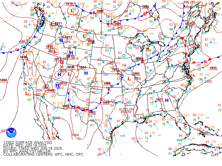
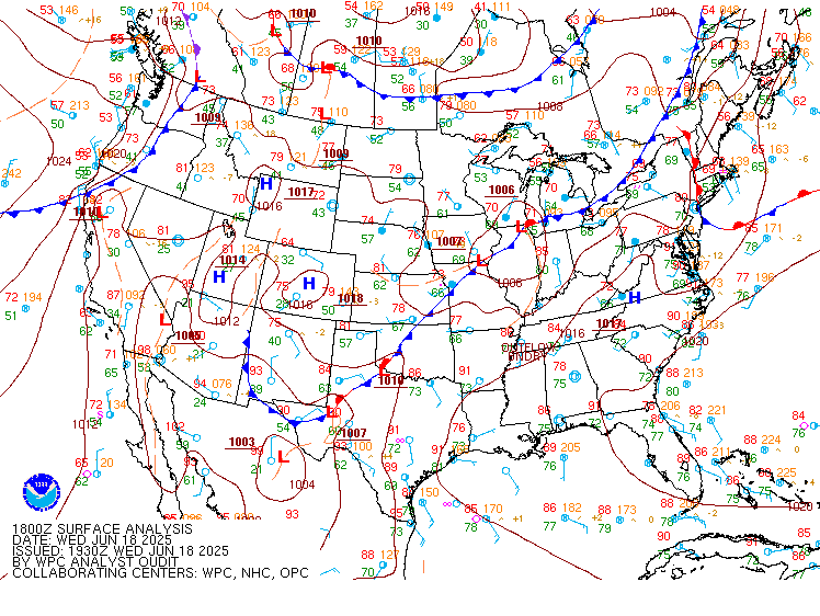
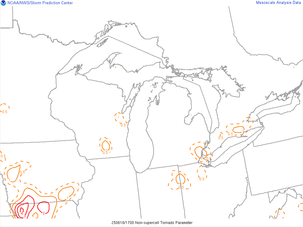
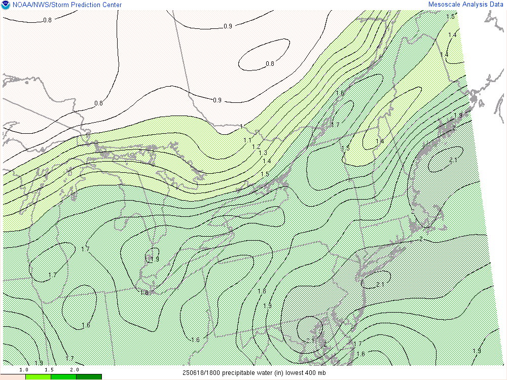
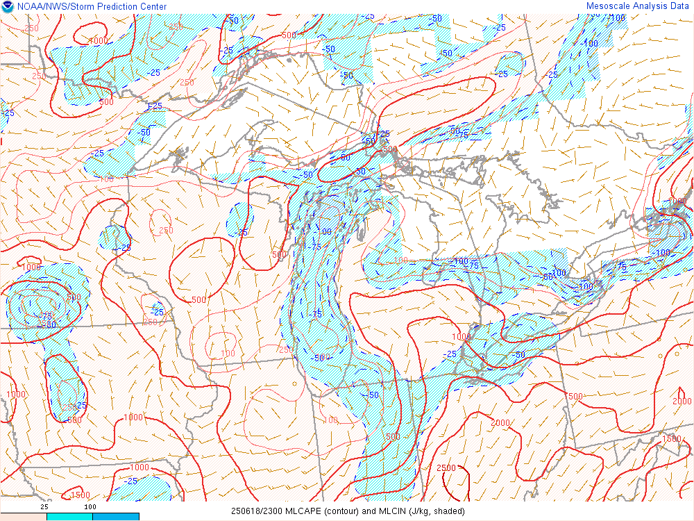
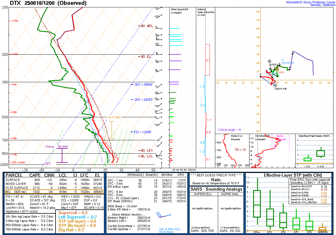
Note the area of non-supercell tornado parameter (Figure 4) that shows values over 1 during the early afternoon. This indicates a favorable combination of low-level instability, little convective inhibition, weak deep-layer veritcal shear, and large cyclonic surface vorticity. As several outflow boundaries collided over Macomb County within this highlighted corridor, conditions were favorable for a brief and weak EF0 tornado in Fraser. High values of precipitable water (Figure 5) characterized a very moist atmosphere that produced torrential downpours and flash flooding during the afternoon. As the organized line of storms moved into the area during the evening hours, environmental mixed-layer convective inhibition (Figure 7, Figure 11) was increasing which led to a gradual weakening of the line and only sporadic damage reports.
 |
 |
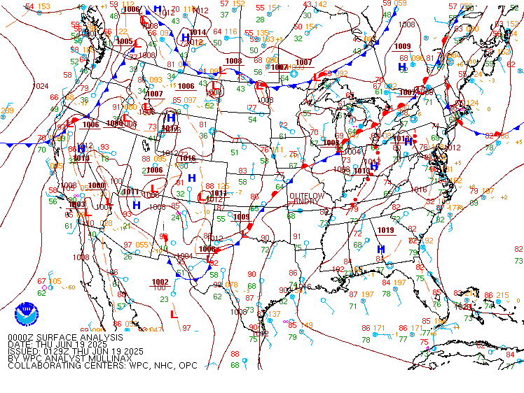 |
| Figure 1: WPC Surface Analysis, valid 12 UTC June 18, 2025 | Figure 2: WPC Surface Analysis, valid 18 UTC June 18, 2025 | Figure 3: WPC Surface Analysis, valid 00 UTC June 19, 2025 |
 |
 |
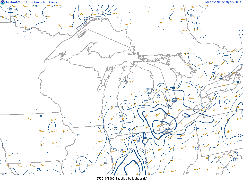 |
| Figure 4: Non-Supercell Tornado Parameter, valid 17 UTC June 18, 2025 | Figure 5: Precipitable water, valid 18 UTC June 18, 2025 | Figure 6: Effective bulk wind shear, valid 23 UTC June 18, 2025 |
 |
 |
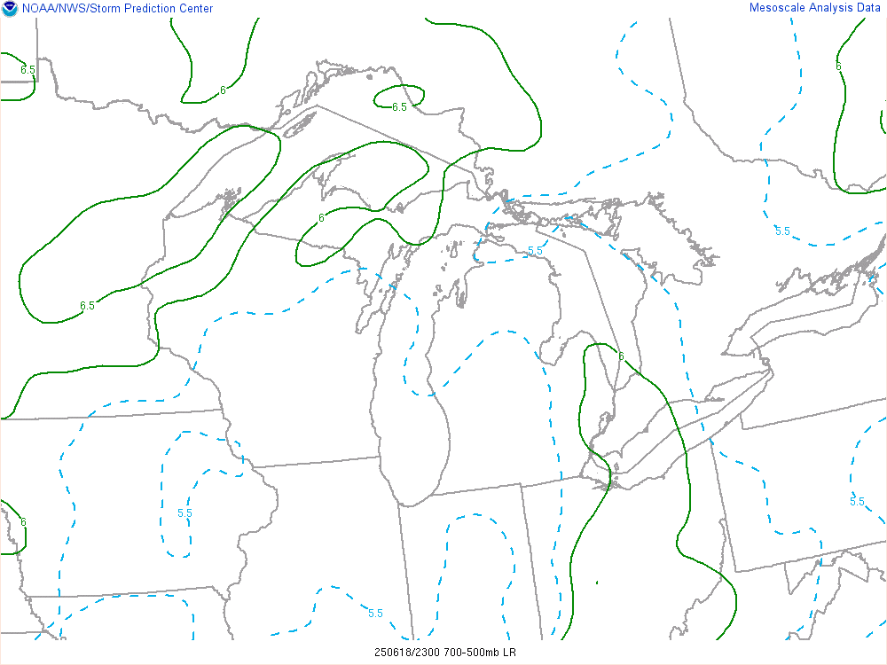 |
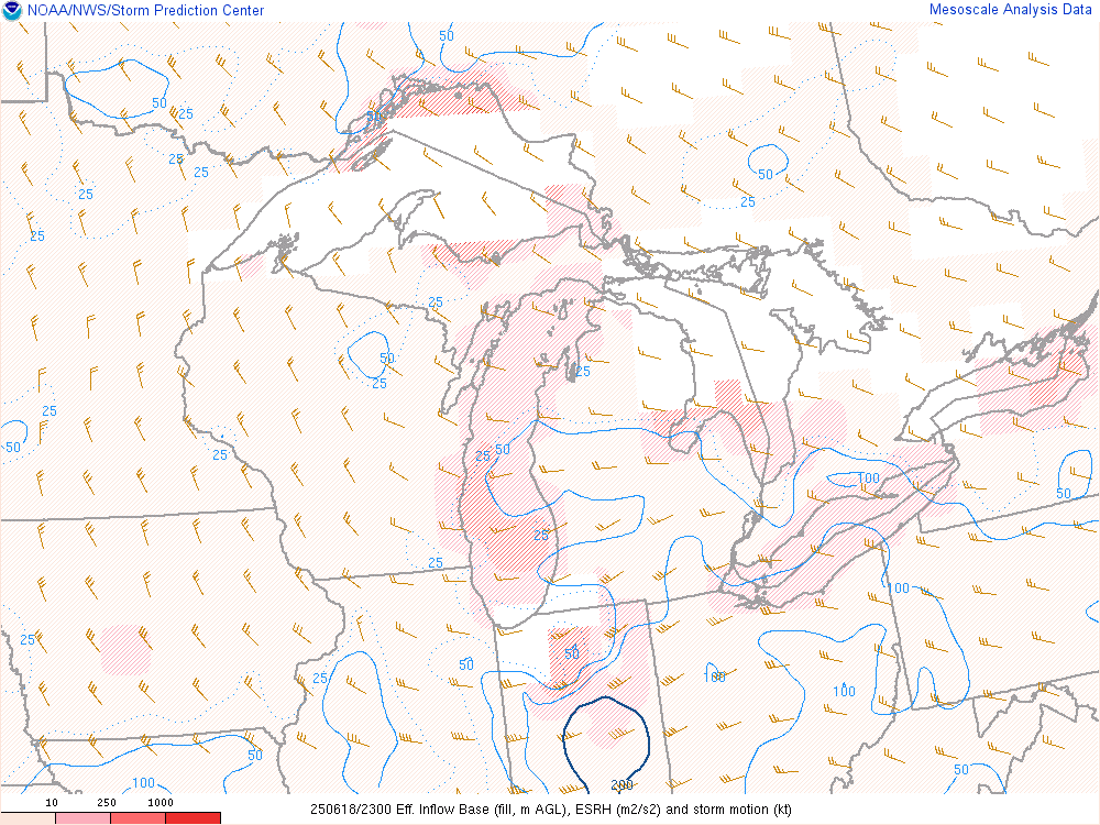
| Figure 7: Mixed-layer CAPE, valid 23 UTC June 18, 2025 | Figure 8: Effective storm-relative helicity, valid 23 UTC June 18, 2025 | Figure 9: Mid-level lapse rates, valid 23 UTC June 18, 2025 |
 |
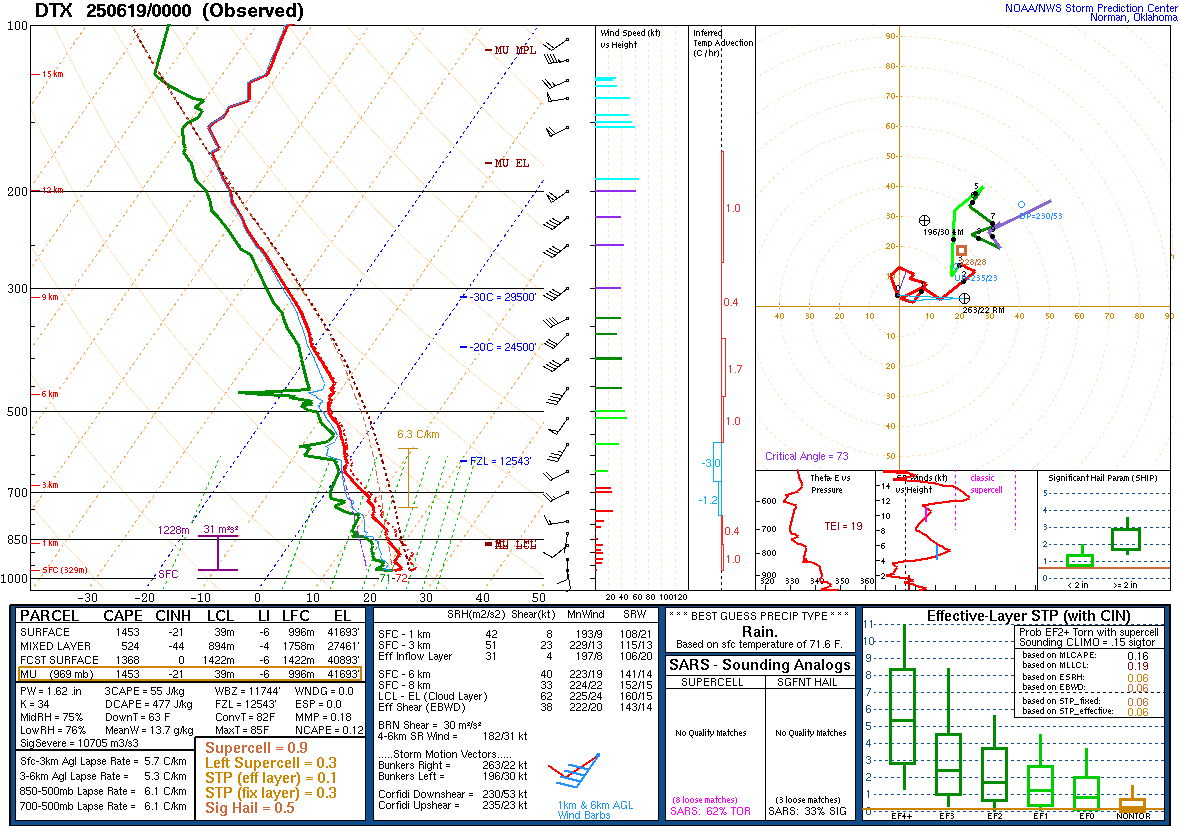 |
| Figure 10: DTX Sounding, valid 12 UTC June 18, 2025 | Figure 11: DTX Sounding, valid 00 UTC June 19, 2025 |
 |
 |
 |
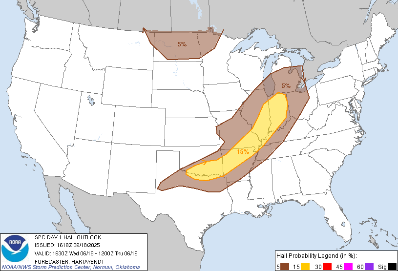 |
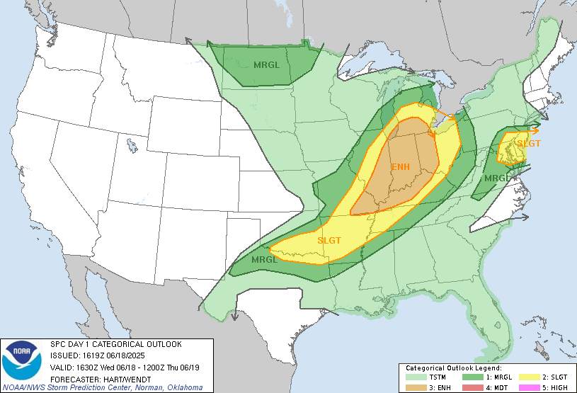
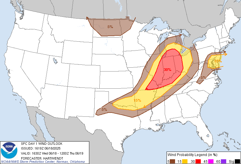
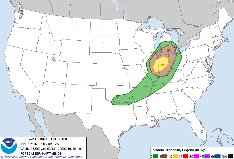
| Figure 12: SPC Categorical Outlook, valid 1630 UTC June 18, 2025 | Figure 13: SPC Probabilistic Damaging Wind Outlook, valid 1630 UTC June 18, 2025 | Figure 14: SPC Probabilistic Tornado Outlook, valid 1630 UTC June 18, 2025 | Figure 15: SPC Probabilistic Hail Outlook, valid 1630 UTC June 18, 2025 |
 |
 |
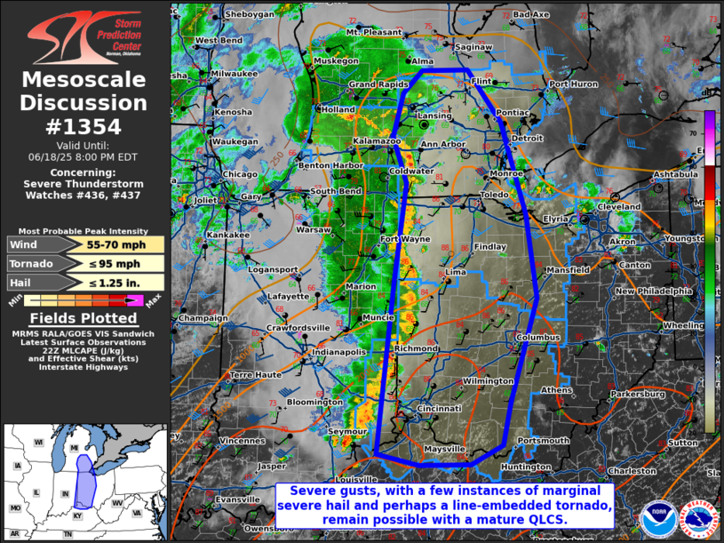 |
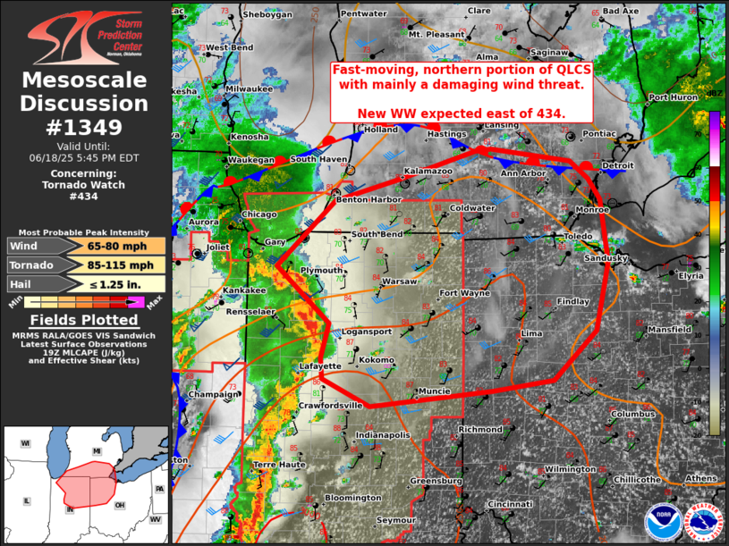
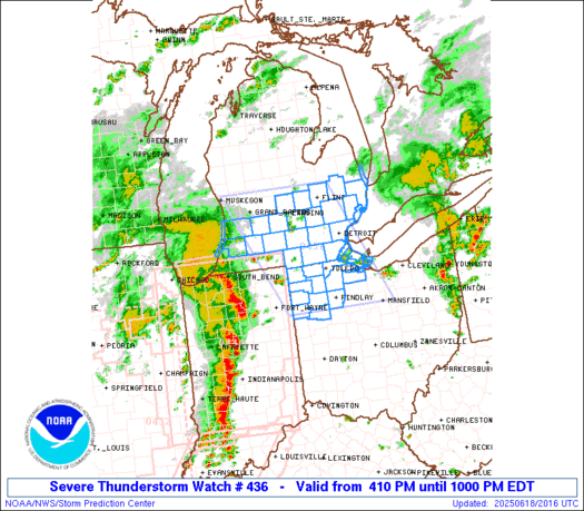
| Figure 16: SPC Mesoscale Discussion #1349, valid 1938 UTC June 18, 2025 | Figure 17: Severe Thunderstorm Watch #436, valid 2010 UTC June 18, 2025 | Figure 18: SPC Mesoscale Discussion #1354, valid 2224 UTC June 18, 2025 |
 |
Media use of NWS Web News Stories is encouraged! Please acknowledge the NWS as the source of any news information accessed from this site. |
|