Overview
A line of severe thunderstorms tracked across Lower Michigan during the afternoon and evening of June 25, 2023, producing widespread wind damage across the state. These storms were part of a bigger system that resulted in nearly 1,000 reports of severe weather across the eastern United States that day, including tornadoes in Indiana, Kentucky, and Arkansas. Locally, storm damage was consistent with 50 to 65 mph straight-line wind gusts for most areas. Parts of Romulus, Dearborn, and Hazel Park were reported to have localized stronger downburst wind gusts. Close to 80,000 customers lost power across the state as a result of the damage.
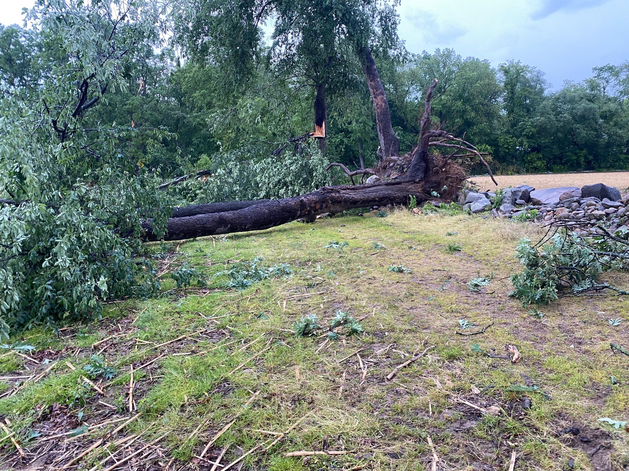
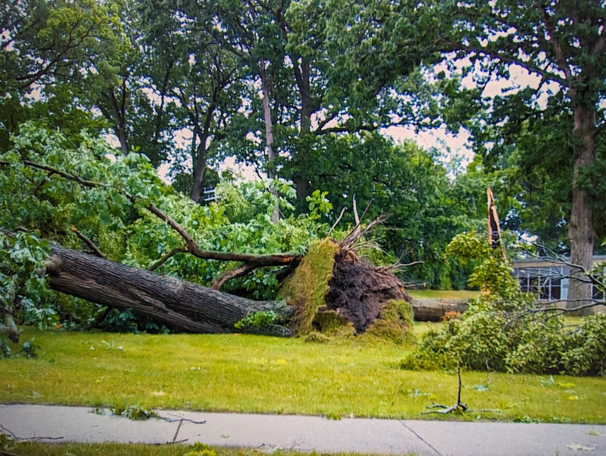
Photos
 |
 |
 |
|
Commerce Township, MI Credit: Rob Long |
Dearborn, MI Credit: Ahmad Bajjey |
Dearborn, MI Credit: Highland Neighborhood Association |
 |
 |
|
|
Waterford Township, MI Credit: Scott Hancock |
Waterford Township, MI Credit: Scott Hancock |
Radar
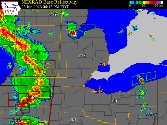  |
|
Click to Enlarge Radar loop courtesy of Iowa Environmental Mesonet (IEM) |
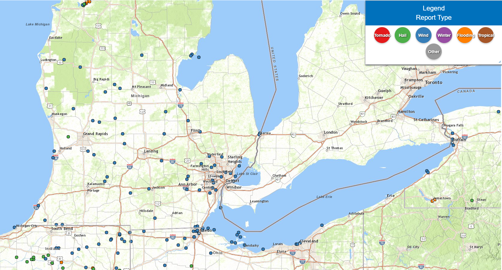
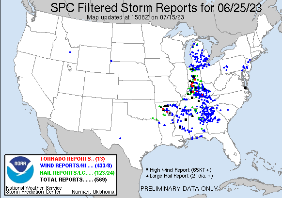
Storm Reports
|
|
|
Map of Local Storm Reports |
Severe Weather Local Storm Reports:
Preliminary Local Storm Report...Summary
National Weather Service Detroit/Pontiac MI
523 AM EDT Wed Jun 28 2023

..TIME...   ...EVENT...      ...CITY LOCATION...     ...LAT.LON...
..DATE...   ....MAG....      ..COUNTY LOCATION..ST.. ...SOURCE....
            ..REMARKS..

0514 PM     Tstm Wnd Dmg     Hudson                  41.86N  84.35W
06/25/2023                   Lenawee            MI   Emergency Mngr

            Numerous large tree limbs down.

0602 PM     Tstm Wnd Dmg     3 SW Ann Arbor          42.25N  83.76W
06/25/2023                   Washtenaw          MI   Amateur Radio

            8 inch large tree limb down along Ann Arbor/Saline
            Road.

0604 PM     Tstm Wnd Dmg     1 SE Lambertville       41.74N  83.61W
06/25/2023                   Monroe             MI   911 Call Center

            Trees down at intersection of Douglas Rd and Smith Rd.

0605 PM     Tstm Wnd Dmg     1 E Liberty Corners     41.75N  83.57W
06/25/2023                   Monroe             MI   911 Call Center

            Wires down at intersection of Lewis Ave and Sterns Rd.

0611 PM     Tstm Wnd Dmg     Owosso                  43.00N  84.18W
06/25/2023                   Shiawassee         MI   911 Call Center

            Trees down.

0622 PM     Tstm Wnd Dmg     1 SSE Whitmore Lake     42.43N  83.74W
06/25/2023                   Washtenaw          MI   Trained Spotter

            Nollar Road completely blocked due to large downed tree
            between 6 Mile Road and 7 Mile Road. Tree diameter
            approximately 24 inches. Time estimated by radar.

0622 PM     Tstm Wnd Dmg     2 E Webster             42.39N  83.76W
06/25/2023                   Washtenaw          MI   Trained Spotter

            Trees down along 6 Mile Road near US 23. Time estimated
            by radar.

0627 PM     Tstm Wnd Gst     2 SE Romulus            42.20N  83.34W
06/25/2023  M61 mph          Wayne              MI   ASOS

            Measured at Detroit Metropolitan Airport.

0627 PM     Tstm Wnd Gst     1 SSW Denton            42.24N  83.53W
06/25/2023  M58 mph          Wayne              MI   ASOS

            Measured at KYIP Willow Run Airport.

0633 PM     Tstm Wnd Dmg     2 S Redford             42.37N  83.29W
06/25/2023                   Wayne              MI   Public

            Several small limbs downed in south Redford from photos
            on social media. Time estimated via radar.

0635 PM     Tstm Wnd Dmg     1 NW Hand               42.27N  83.29W
06/25/2023                   Wayne              MI   Public

            Trees down at intersection of Van Born and Beech Daly
            Roads. Time estimated by radar.

0635 PM     Tstm Wnd Dmg     St. Charles             43.30N  84.15W
06/25/2023                   Saginaw            MI   911 Call Center

            Trees down. Time estimated by radar.

0635 PM     Tstm Wnd Dmg     1 SW Allen Park         42.24N  83.23W
06/25/2023                   Wayne              MI   Broadcast Media

            Large tree blown down on house causing significant
            damage near Wick and Pelham

0639 PM     Tstm Wnd Gst     4 SE Milleville Beach   42.00N  83.14W
06/25/2023  M53 mph          LEZ444             MI   Mesonet

            Measured at Detroit River Light.

0643 PM     Tstm Wnd Dmg     1 NW Commerce           42.60N  83.50W
06/25/2023                   Oakland            MI   Public

            Numerous trees down.

0645 PM     Tstm Wnd Dmg     Bloomfield Hills        42.58N  83.25W
06/25/2023                   Oakland            MI   Trained Spotter

            Trees down. Time estimated by radar.

0645 PM     Tstm Wnd Dmg     2 NW Highland Park      42.42N  83.13W
06/25/2023                   Wayne              MI   Broadcast Media

            Large tree down on car at Detroit Golf Club

0647 PM     Tstm Wnd Dmg     2 N Franklin            42.55N  83.31W
06/25/2023                   Oakland            MI   Trained Spotter

            Large tree down on road, along with many tree limbs
            reported down.

0651 PM     Tstm Wnd Dmg     1 NNE Clintonville      42.70N  83.35W
06/25/2023                   Oakland            MI   Public

            Trees down near Clintonville Rd. Time estimated by
            radar.

0655 PM     Tstm Wnd Dmg     1 WSW Center Line       42.48N  83.05W
06/25/2023                   Macomb             MI   Trained Spotter

            14 inch diameter tree downed near 10 Mile and Mound Rd.

0707 PM     Tstm Wnd Gst     Grosse Pointe Shores    42.43N  82.87W
06/25/2023  M65 mph          LCZ460             MI   Mesonet

            Measured at Grosse Pointe Yacht Club.

0708 PM     Tstm Wnd Dmg     Rochester               42.69N  83.12W
06/25/2023                   Oakland            MI   Trained Spotter

            Tree down on road at intersection of Linwood Ave and
            Mahaffy Ave.

0709 PM     Tstm Wnd Dmg     Clio                    43.18N  83.74W
06/25/2023                   Genesee            MI   911 Call Center

            Numerous wires down. Time estimated by radar.

0709 PM     Tstm Wnd Dmg     Bay City                43.59N  83.89W
06/25/2023                   Bay                MI   911 Call Center

            Numerous trees and wires down. Additional trees and
            wires down reported throughout the county.

0710 PM     Tstm Wnd Gst     2 S Grosse Pointe       42.36N  82.91W
06/25/2023  M55 mph          LCZ460             MI   Mesonet

            Measured at Peche Island Light.

0714 PM     Tstm Wnd Dmg     Davison                 43.03N  83.52W
06/25/2023                   Genesee            MI   911 Call Center

            Numerous wires down across multiple roadways. Time
            estimated by radar.

0720 PM     Tstm Wnd Dmg     Eastpointe              42.47N  82.96W
06/25/2023                   Macomb             MI   Trained Spotter

            Tree down blocking road. Time estimated by radar.

0721 PM     Tstm Wnd Gst     1 SSW Saint Clair Haven 42.57N  82.80W
06/25/2023  M46 mph          Macomb             MI   Mesonet

            Measured at Lake St. Clair Metropark.

0800 PM     Tstm Wnd Gst     14 WNW Caseville        44.02N  83.54W
06/25/2023  M44 mph          LHZ421             MI   Buoy

            Measured at Gravelly Shoal Light.

0811 PM     Tstm Wnd Dmg     Port Huron              42.99N  82.43W
06/25/2023                   St. Clair          MI   911 Call Center

            Trees down. Downed wires also reported throughout St.
            Clair county.

0818 PM     Tstm Wnd Gst     1 NNE Port Huron        43.01N  82.42W
06/25/2023  M41 mph          LHZ443             MI   Mesonet

            Measured at Fort Gratiot FTGM4.
 |
|
National Storm Reports for June 25, 2023 |
Environment
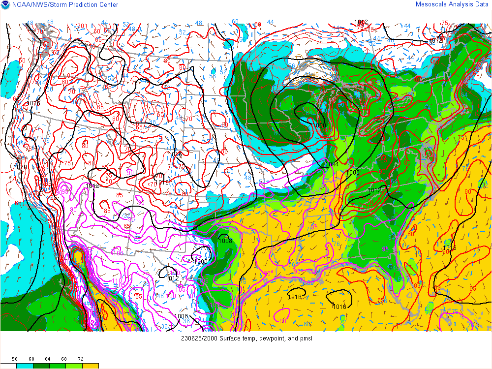
A mid-level shortwave trough moved into the Midwest on June 24, resulting in a surface low pressure system developing and tracking eastward into the western Great Lakes by early June 25. This system became occluded by the time it moved into Southeast Michigan that evening, with a cold front that extended through the Ohio and Mississippi Valleys into the Southern Plains (Figure 1). Areas along and ahead of the trailing cold front were outlined in Slight to Enhanced Risk areas in the Storm Prediction Center's Day 1 Severe Weather Outlook (Figure 2), and these areas saw the majority of the storm reports that day.
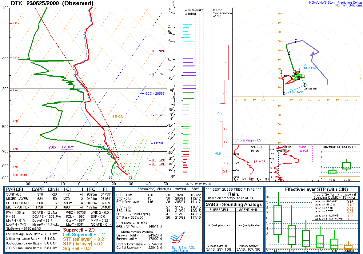
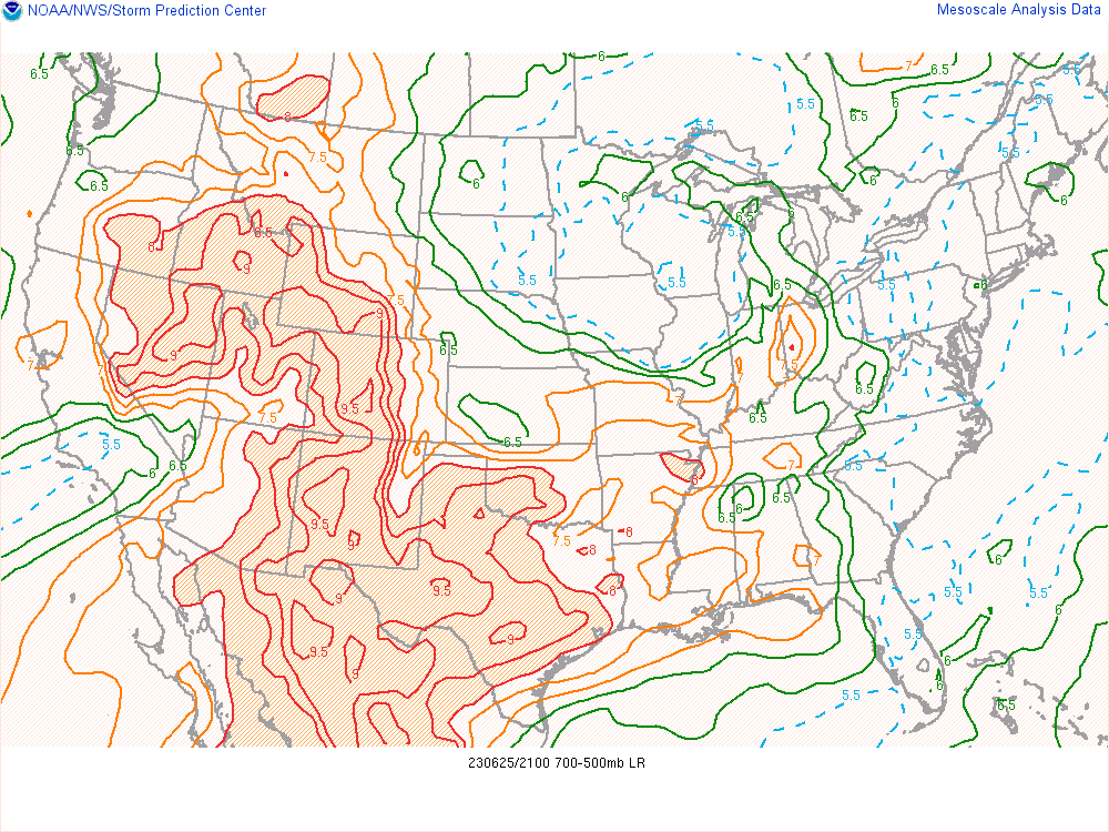
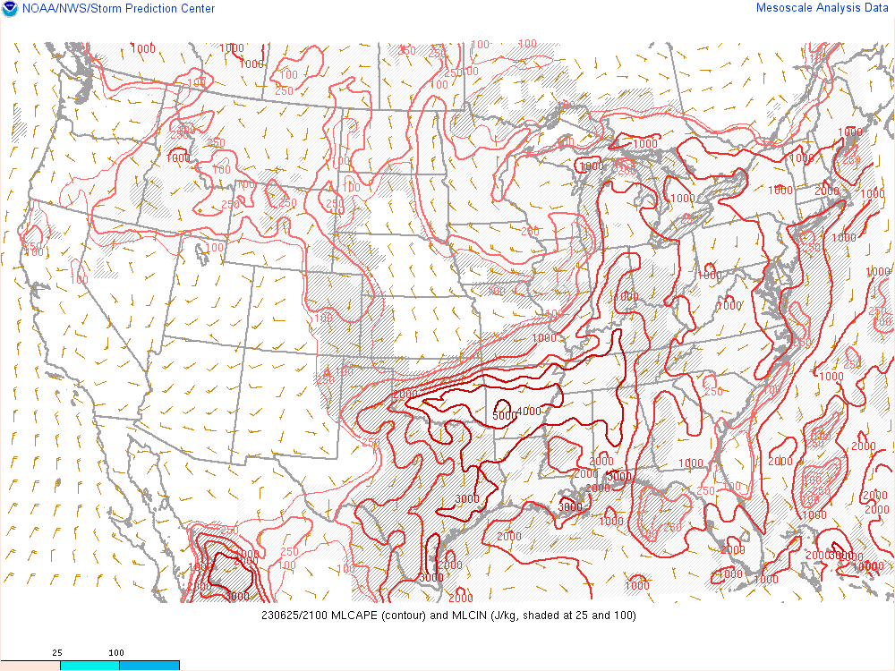
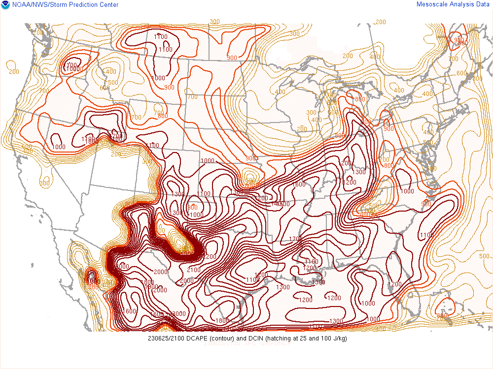
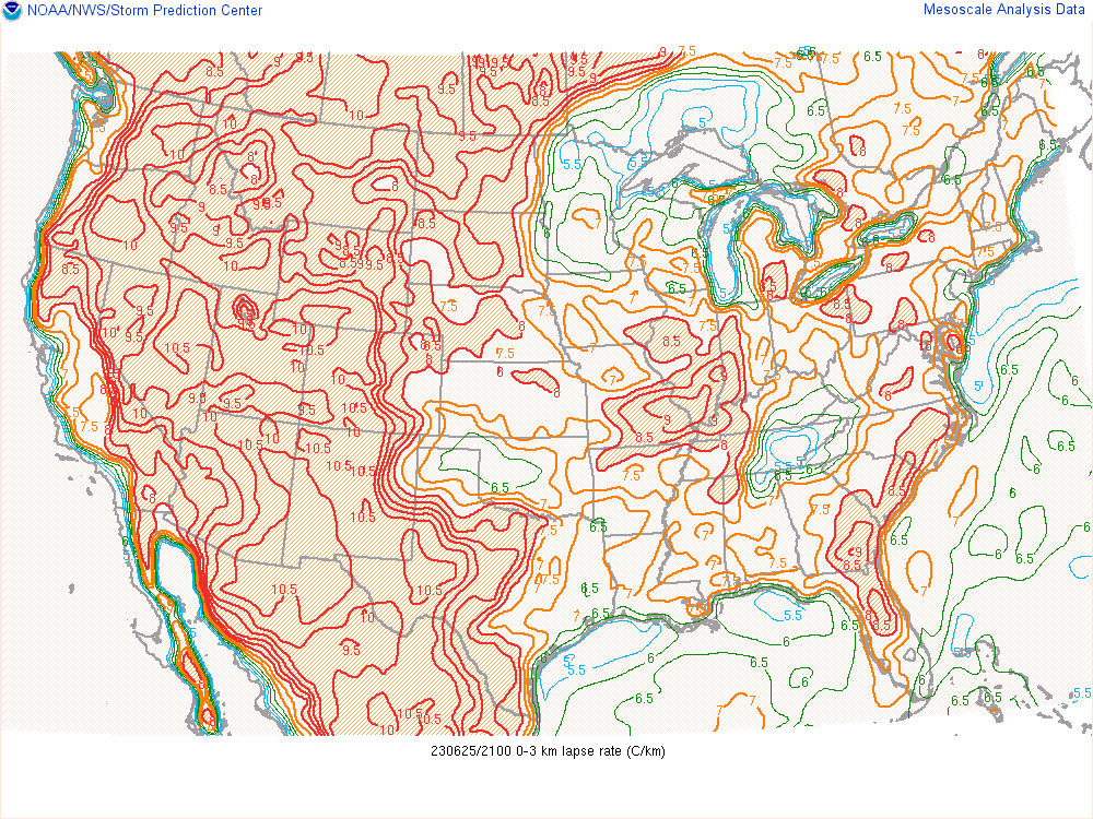
NWS Detroit launched a special 20z weather balloon to analyze the pre-storm environment (Figure 3). Of note in this sounding was a deep dry layer from 650mb to 325mb, which aided in mid-level evaporational cooling potential and the development of strong downburst winds through the event. The DCAPE of 1205 J/kg (Figure 7) characterized this environment capable of strong downburst winds. Also aiding in strong downburst production was relatively strong low-level lapse rates of over 7 C/km (Figure 8). Mid-level lapse rates were modest at 5.8 C/km, but upstream in the Ohio Valley values were higher (Figure 4) as the system had advected in an elevated mixed layer (EML) to that area. Surface dew points in the 60s (Figure 6) helped to produce favorable instability with around 1000-1500 J/kg of MLCAPE (Figure 5) analyzed. Wind shear measured by the weather balloon was overall modest, with 27 knots of wind shear between the surface and 6 km aloft. Effective wind shear for storms to ingest was similar at 26 knots (Figure 9). This was enough for storms to maintain their linear organization and produce damaging winds across the area, but was likely a limiting factor preventing storms from producing even stronger winds or more widespread damage.
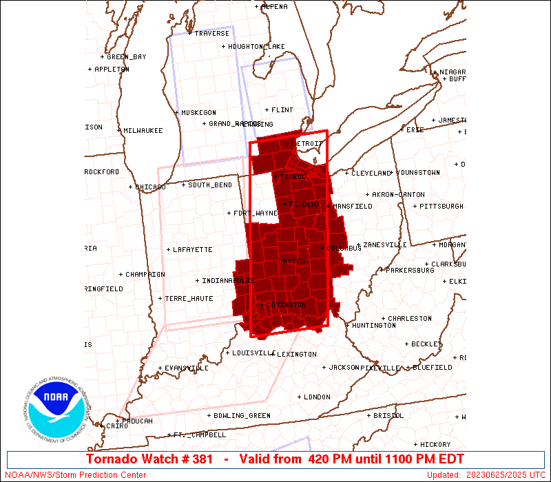
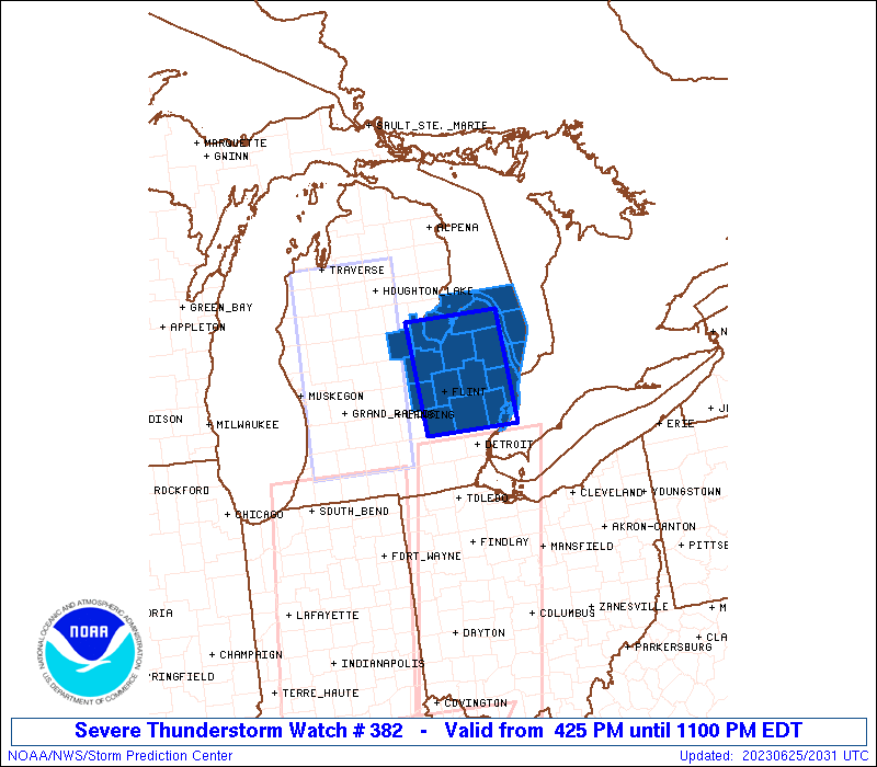
During this event a Tornado Watch was issued for Monroe, Lenawee, Washtenaw, and Wayne Counties (Figure 10), and a Severe Thunderstorm Watch was issued for the remainder of Southeast Michigan (Figure 11).
Click on the images below to see them expanded.
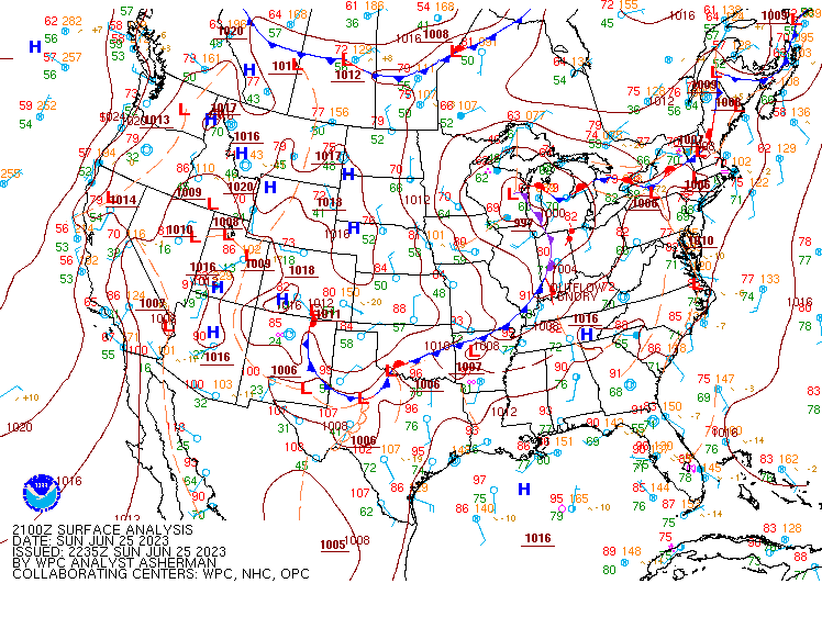 |
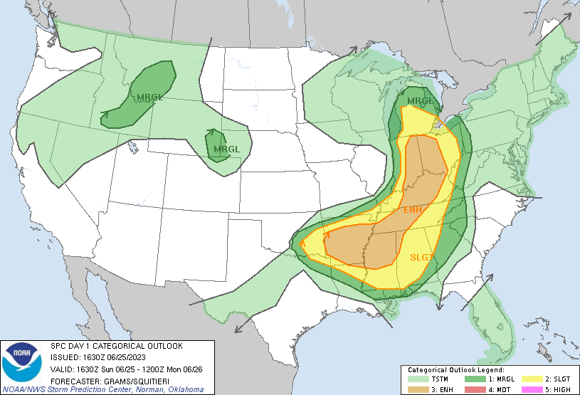 |
 |
| Figure 1: WPC Surface Analysis, valid 21 UTC 25 June 2023 | Figure 2: SPC Day 1 Outlook, valid 1630 UTC 25 June 2023 | Figure 3: KDTX Observed Sounding, valid 20 UTC 25 June 2023 |
 |
 |
 |
| Figure 4: Mid Level Lapse Rates, valid 21 UTC 25 June 2023 | Figure 5: Mixed-Layer CAPE, valid 21 UTC 25 June 2023 | Figure 6: Surface Dew Points, valid 20 UTC 25 June 2023 |
 |
 |
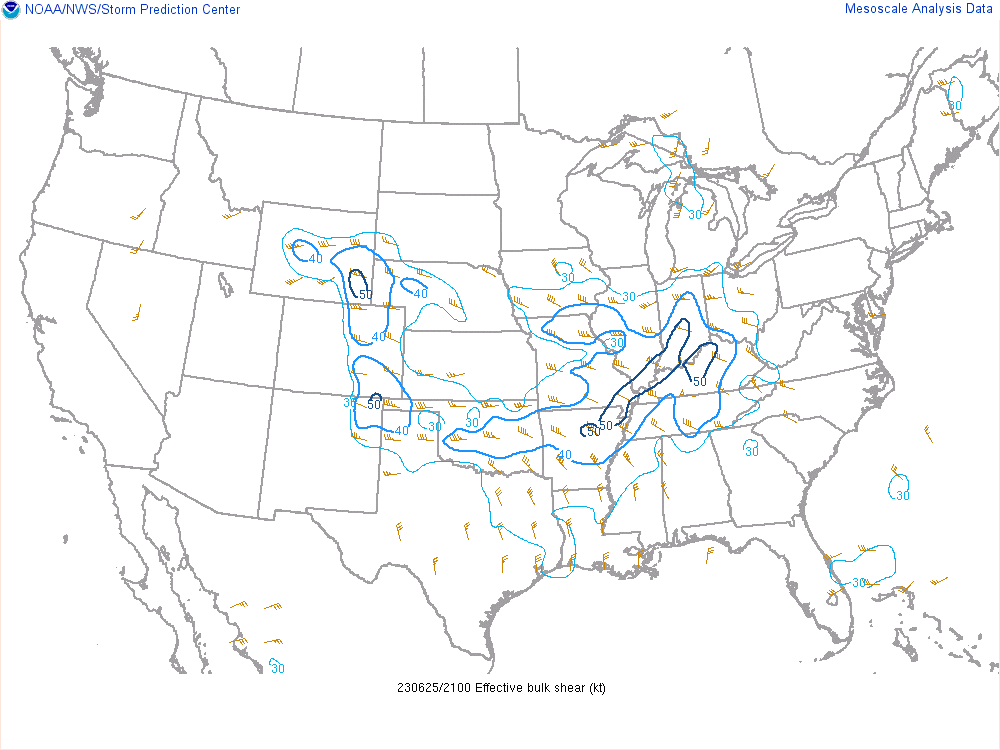 |
| Figure 7: Downdraft CAPE, valid 21 UTC 25 June 2023 | Figure 8: 0-3 km Lapse Rates, valid 21 UTC 25 June 2023 | Figure 9: Effective Bulk Wind Shear, valid 21 UTC 25 June 2023 |
 |
 |
|
| Figure 10: Tornado Watch 381, valid 25 June 2023 | Figure 11: Severe Thunderstorm Watch 382, valid 25 June 2023 |
 |
Media use of NWS Web News Stories is encouraged! Please acknowledge the NWS as the source of any news information accessed from this site. |
|