Overview
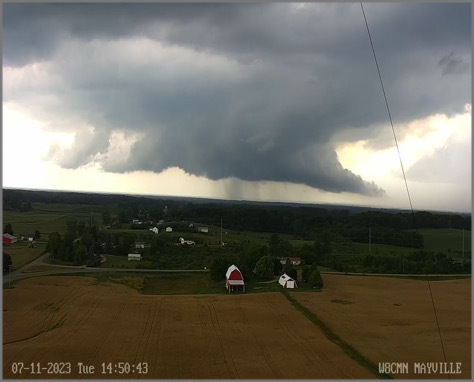
Scattered severe thunderstorms began to develop across northern portions of Southeast Michigan in the early afternoon of July 11, 2023, as a strong cold front sagged southward across the area. Severe thunderstorms continued to impact parts of the area as storms moved eastward before diminishing in the early evening as the cold front moved out of the area. Damage from straight lined winds included numerous large tree limbs and power lines down. Mid level rotation was indicated on radar which led to a tornado warning and a wall cloud was reported near Mayville, Michigan. This isolated storm also produced one inch hail in Vassar, Michigan.
Photos
 |
 |
 |
|
Mayville, MI Credit: Fred Moses |
Brown City, MI Credit: Mary Stikeleather Piorunek |
Gregory, MI Credit: Kris Kashubosky DeAngelo |
 |
 |
|
|
Macomb Township, MI Credit: Brendan Morang |
Macomb Township, MI Credit: Brendan Morang |
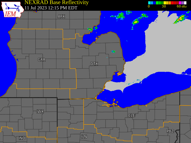
Radar
  |
|
Click to Enlarge Radar loop courtesy of Iowa Environmental Mesonet (IEM) |
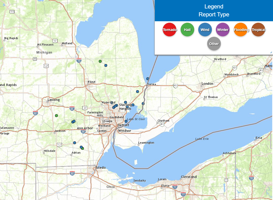
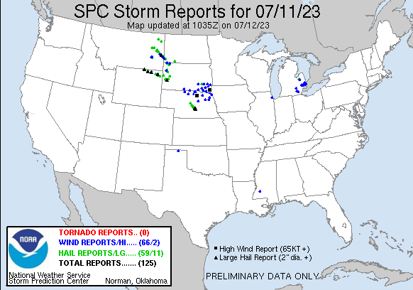
Storm Reports
|
|
|
Map of Local Storm Reports July 11, 2023 |
Severe Weather Local Storm Reports:
Preliminary Local Storm Report...Summary
National Weather Service Detroit/Pontiac MI
908 AM EDT Wed Jul 12 2023

..TIME...   ...EVENT...      ...CITY LOCATION...     ...LAT.LON...
..DATE...   ....MAG....      ..COUNTY LOCATION..ST.. ...SOURCE....
            ..REMARKS..

0250 PM     Tstm Wnd Gst     5 NNE Keewahdin         43.10N  82.40W
07/11/2023  M40 mph          LHZ443             MI   Buoy

            Measured at Buoy 45209

0252 PM     Hail             8 E Vassar              43.37N  83.42W
07/11/2023  M1.00 inch       Tuscola            MI   Broadcast Media

            Picture of quarter sized hail

0313 PM     Tstm Wnd Dmg     3 WSW Silverwood        43.31N  83.30W
07/11/2023                   Lapeer             MI   911 Call Center

            Dispatch reports wires down across the northern portion
            of Lapeer county with a tree down near Mayville

0402 PM     Tstm Wnd Dmg     Hell                    42.43N  83.98W
07/11/2023                   Livingston         MI   Broadcast Media

            Tree and large limbs down with small hail

0402 PM     Tstm Wnd Dmg     1 SSE Chalkerville      42.42N  84.01W
07/11/2023                   Washtenaw          MI   Emergency Mngr

            EM reports numerous trees down on houses, numerous
            wires down, and a 20ft pontoon boat was flipped on
            Halfmoon Lake

0436 PM     Rain             3 W Lakeport            43.11N  82.56W
07/11/2023  M2.20 inch       St. Clair          MI   Public

0442 PM     Tstm Wnd Dmg     1 SW Goodison           42.72N  83.17W
07/11/2023                   Oakland            MI   Public

            Social media picture of tree across road near the
            intersection of Silverbell and Gallagher Rds

0443 PM     Tstm Wnd Dmg     1 ESE Rochester Hills   42.65N  83.13W
07/11/2023                   Oakland            MI   Trained Spotter

            Large limbs down area the area of Rochester Rd, Hamlin
            Rd, and Avon Rds

0444 PM     Tstm Wnd Dmg     Yates                   42.67N  83.10W
07/11/2023                   Oakland            MI   Trained Spotter

            Large limbs down causing damage to house siding near
            Avon and Dequindre

0449 PM     Tstm Wnd Dmg     2 ENE Yates             42.68N  83.07W
07/11/2023                   Macomb             MI   Trained Spotter

            Numerous large limbs down around 24 mile and Shelby Rd

0500 PM     Tstm Wnd Dmg     1 NW Allen`s Trailer Co 42.09N  83.97W
07/11/2023                   Washtenaw          MI   Emergency Mngr

            EM reports numerous trees down and damage to a barn
            near Clinton and Allen Rds

0503 PM     Tstm Wnd Dmg     1 N Meade               42.73N  82.88W
07/11/2023                   Macomb             MI   Public

            Large tree limbs down partially blocking North Ave
            between 26 and 27 mile rds

0505 PM     Tstm Wnd Dmg     Chesterfield            42.66N  82.84W
07/11/2023                   Macomb             MI   Public

            Social media pictures of numerous trees down in yards,
            across streets, and on power lines

0512 PM     Tstm Wnd Dmg     1 ENE New Baltimore     42.69N  82.72W
07/11/2023                   Macomb             MI   Public

            Social media pictures of large limbs down near M-29 and
            Walpole.

0520 PM     Tstm Wnd Dmg     3 N Britton             42.02N  83.83W
07/11/2023                   Lenawee            MI   Trained Spotter

            Pictures of tree uprooted, numerous tree limbs of
            various sizes down

0525 PM     Hail             2 ENE Britton           42.00N  83.80W
07/11/2023  M1.00 inch       Lenawee            MI   Trained Spotter

            Quarter size hail along the edge of the hail core

0528 PM     Tstm Wnd Dmg     Marine City             42.72N  82.49W
07/11/2023                   St. Clair          MI   Trained Spotter

            Snapped power pole and large tree limb down on house.

0530 PM     Tstm Wnd Dmg     Marine City             42.71N  82.50W
07/11/2023                   St. Clair          MI   Trained Spotter

            Tree limbs down throughout town

0548 PM     Tstm Wnd Dmg     1 SW Smiths Creek       42.90N  82.62W
07/11/2023                   St. Clair          MI   Trained Spotter

            Large limbs down in yard near Mayer and Yager Rds

0600 PM     Rain             Jeddo                   43.15N  82.58W
07/11/2023  M2.00 inch       St. Clair          MI   Trained Spotter

            4 hour rainfall total.

0621 PM     Tstm Wnd Gst     Grosse Pointe Shores    42.43N  82.87W
07/11/2023  M41 mph          LCZ460             MI   Mesonet

            Measured at Grosse Pointe Yacht Club

1200 AM     Rain             Adrian                  41.90N  84.04W
07/12/2023  M1.09 inch       Lenawee            MI   Co-Op Observer

            24 hour rainfall total.
 |
|
National Storm Reports for July 11, 2023 |
Environment
Click on the images below to see them expanded.
 |
 |
 |
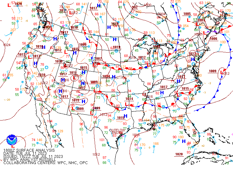
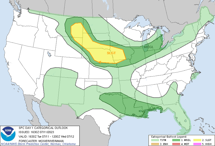
| Figure 1: WPC Surface Analysis, valid 18 UTC July 11, 2023 | Figure 2: SPC Day 1 Outlook, valid 1630 UTC July 11, 2023 | Figure 3: KDTX Observed Sounding, valid 20 UTC July 11, 2023 |
 |
 |
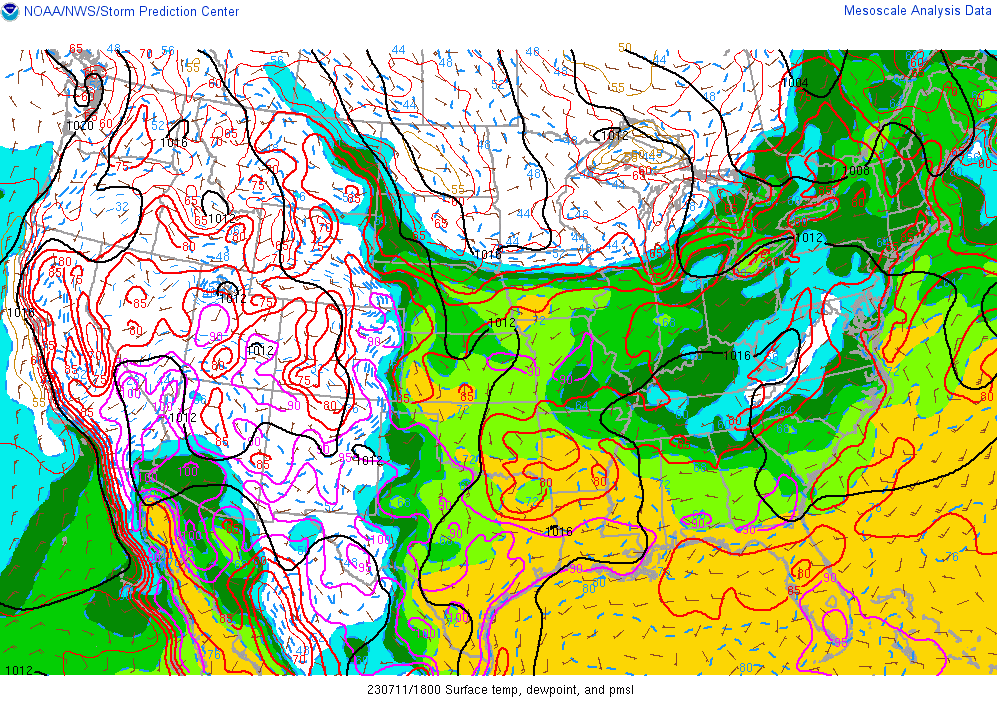 |
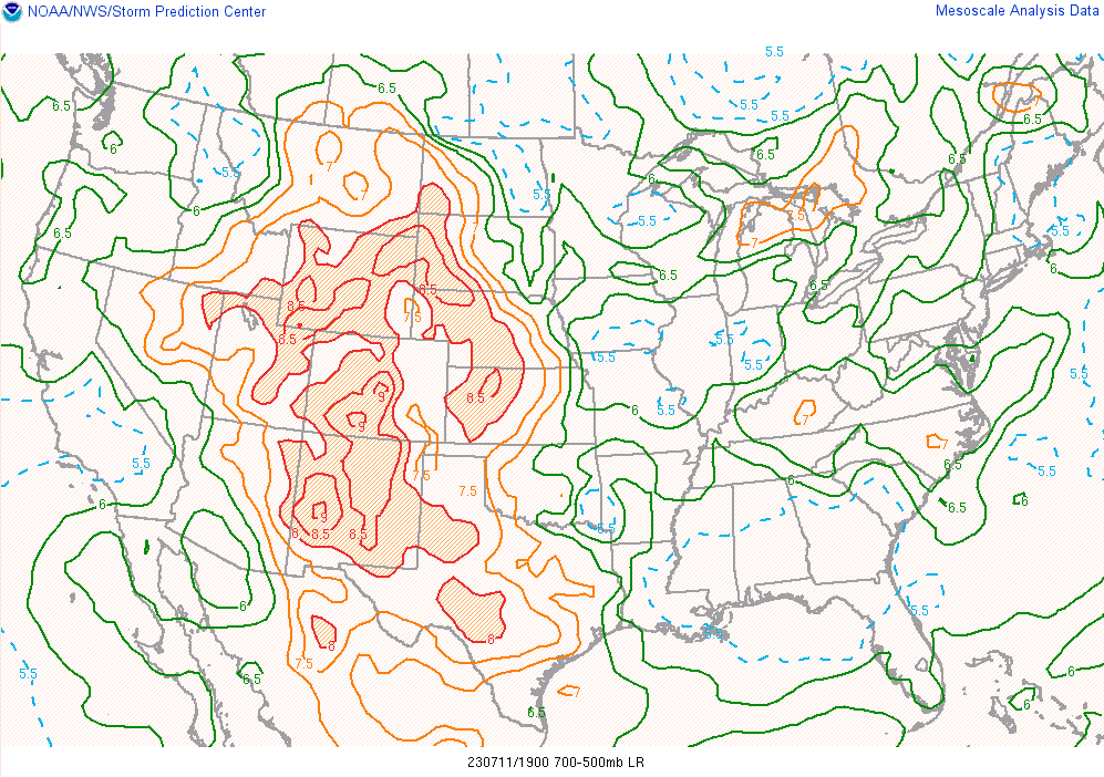
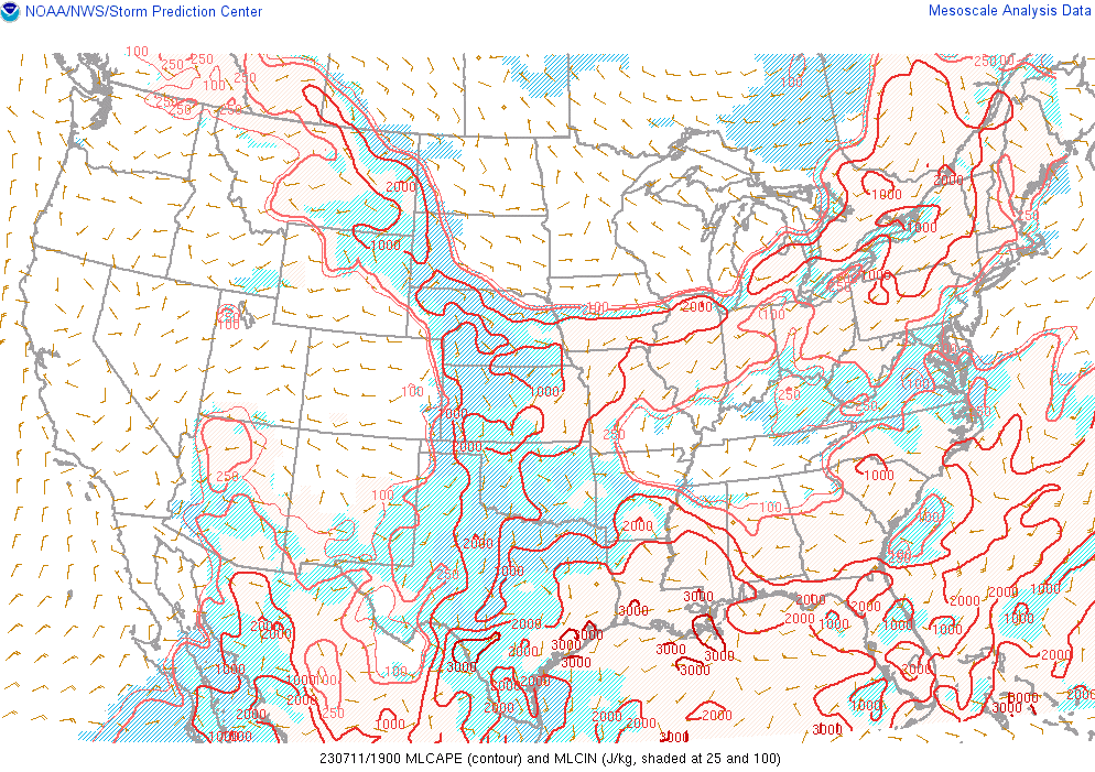
| Figure 4: Mid Level Lapse Rates, valid 19 UTC July 11, 2023 | Figure 5: Mixed-Layer CAPE, valid 19 UTC July 11, 2023 | Figure 6: Surface Dew Points, valid 18 UTC July 11, 2023 |
 |
 |
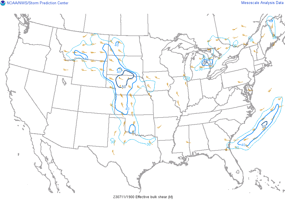 |
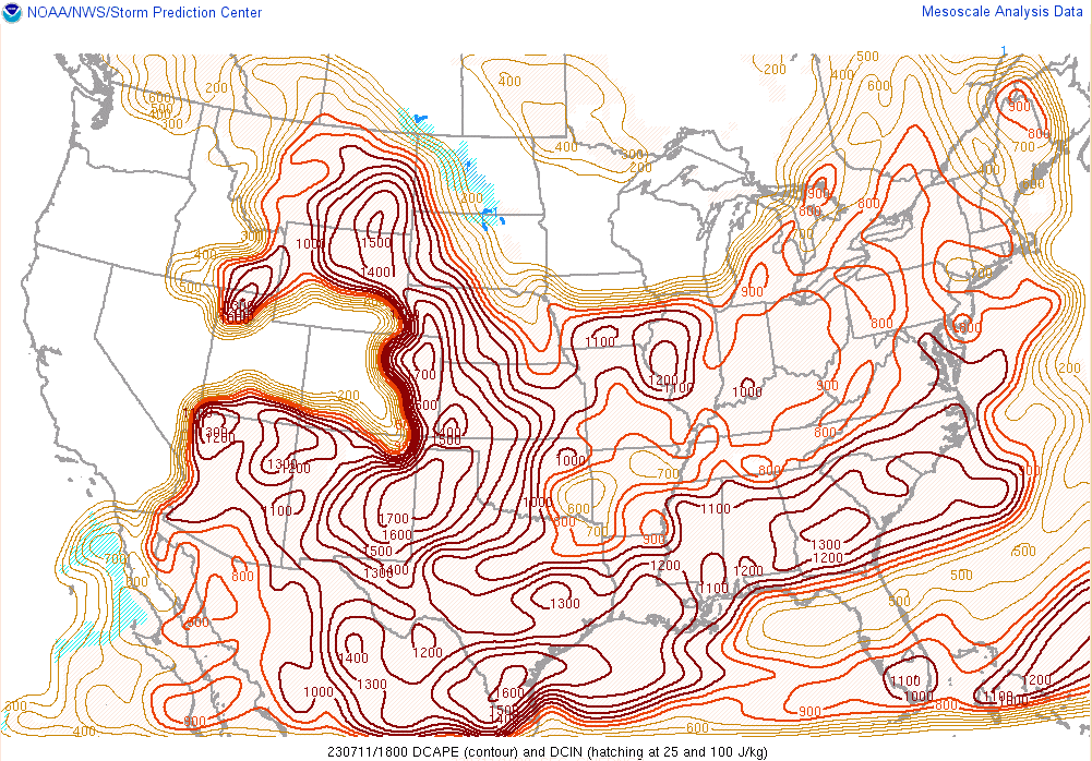
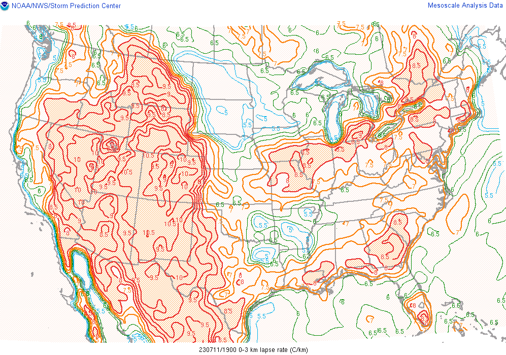
| Figure 7: Downdraft CAPE, valid 18 UTC July 11, 2023 | Figure 8: 0-3 km Lapse Rates, valid 19 UTC July 11, 2023 | Figure 9: Effective Bulk Wind Shear, valid 19 UTC July 11, 2023 |
 |
Media use of NWS Web News Stories is encouraged! Please acknowledge the NWS as the source of any news information accessed from this site. |
|