Overview
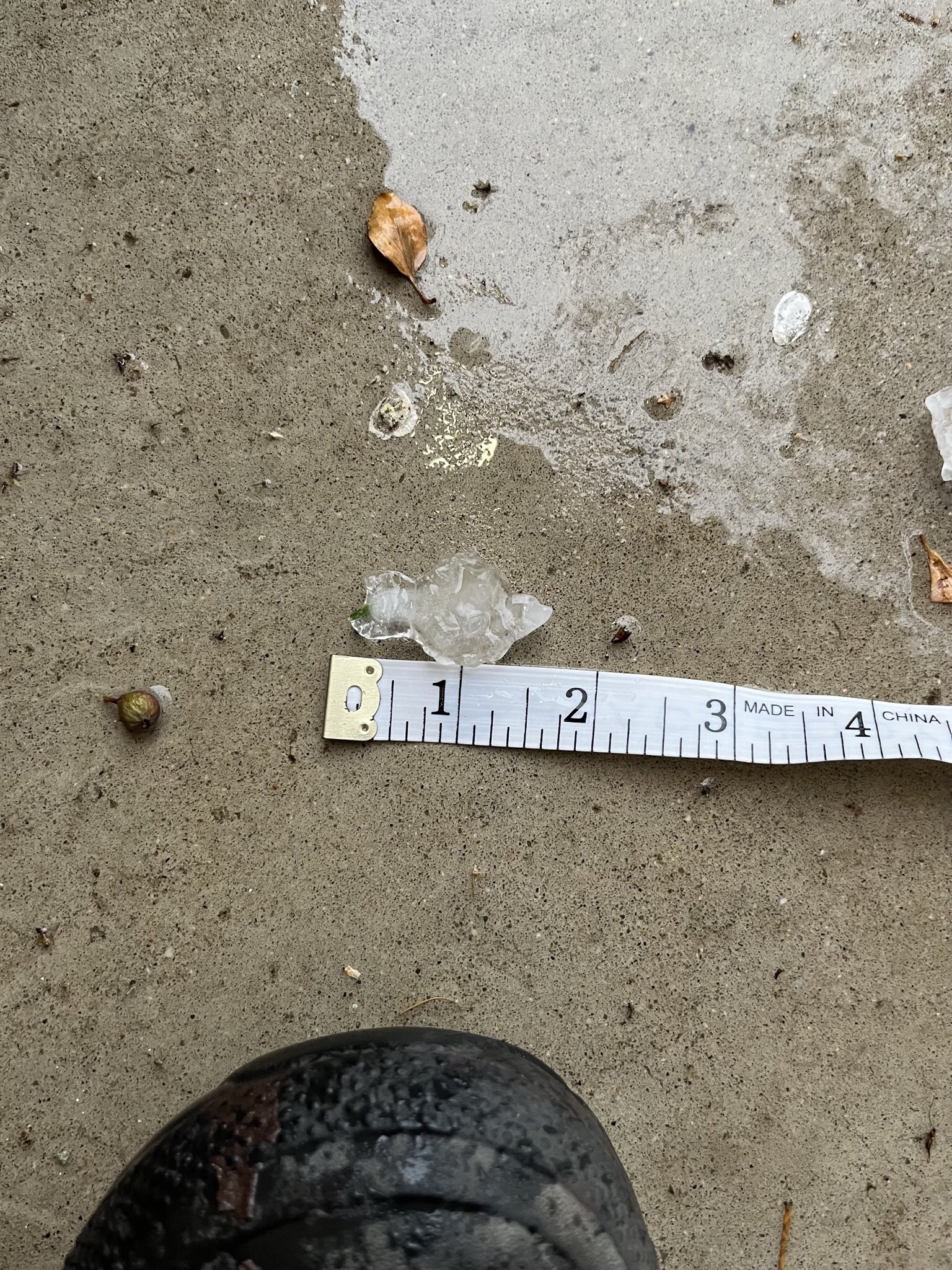
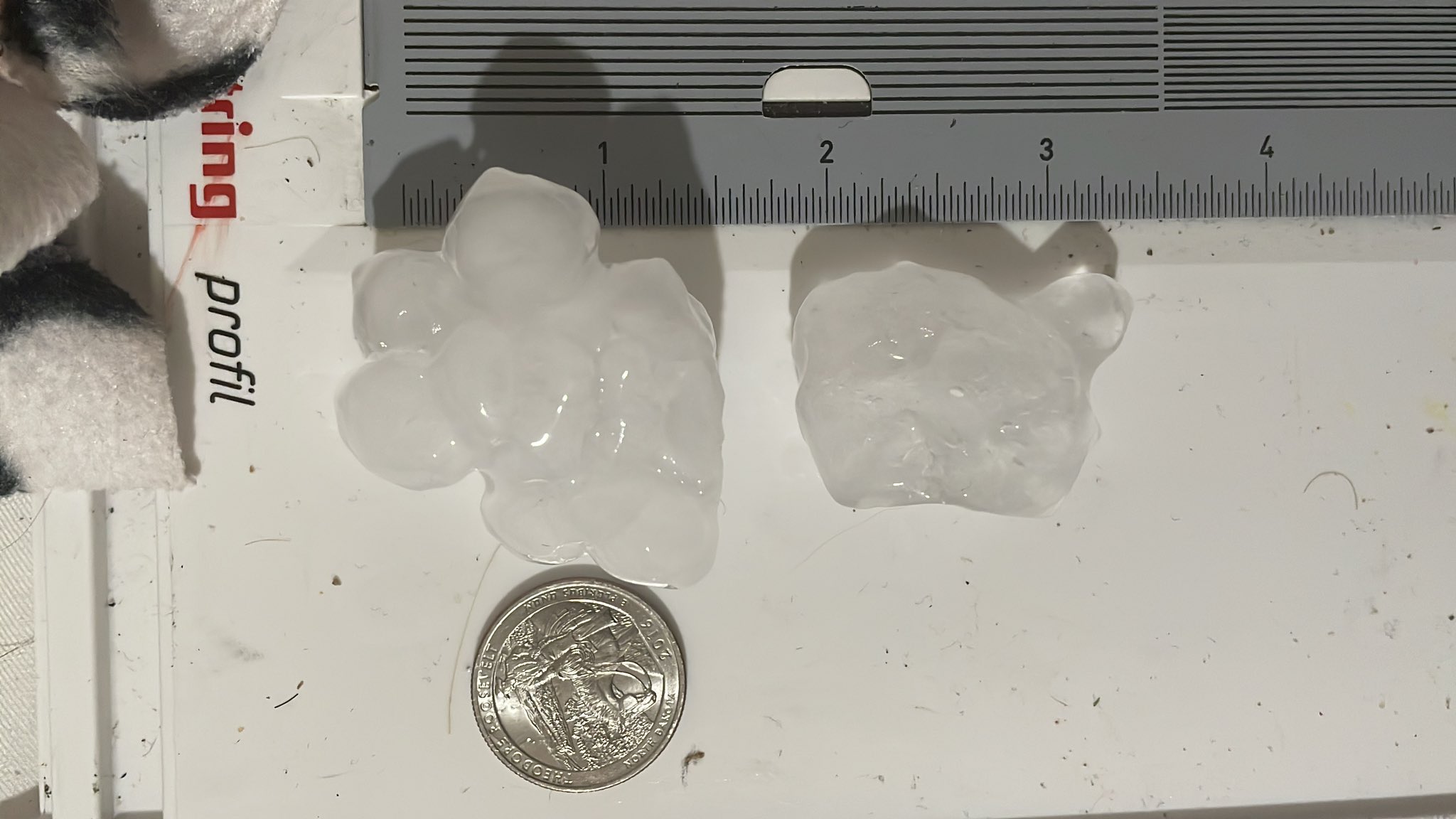
A combination of squall line thunderstorms tied to a strong cold front and pre-frontal supercells brought severe weather to parts of Southeast Michigan Thursday afternoon and early evening on July 20,2023. In total, 12 Severe Thunderstorm Warnings and 6 Special Marine Warnings were issued. One supercell that developed just before the arrival of the squall line produced 2.75 inch (Baseball size) hail over Davison, MI leading to widespread hail damage to vehicles, homes, and businesses. This was the largest hail reported since a supercell moved through Hudson, MI on June 20, 2021 producing 2.75 to 3 inch (Baseball to Large Apple (size) hail. Several other locations also received severe hail, including Ypsilanti where 2 inch (Lime size) hail fell and Ann Arbor which experienced 1.5 inch (Ping Pong size) hail, shutting down the Ann Arbor Art Fair for a couple hours. Additionally, there were numerous reports of downed trees (some of which fell on homes), several measured wind gusts in excess of 50 mph, and a waterspout over Anchor Bay.
Photos
 |
 |
 |
|
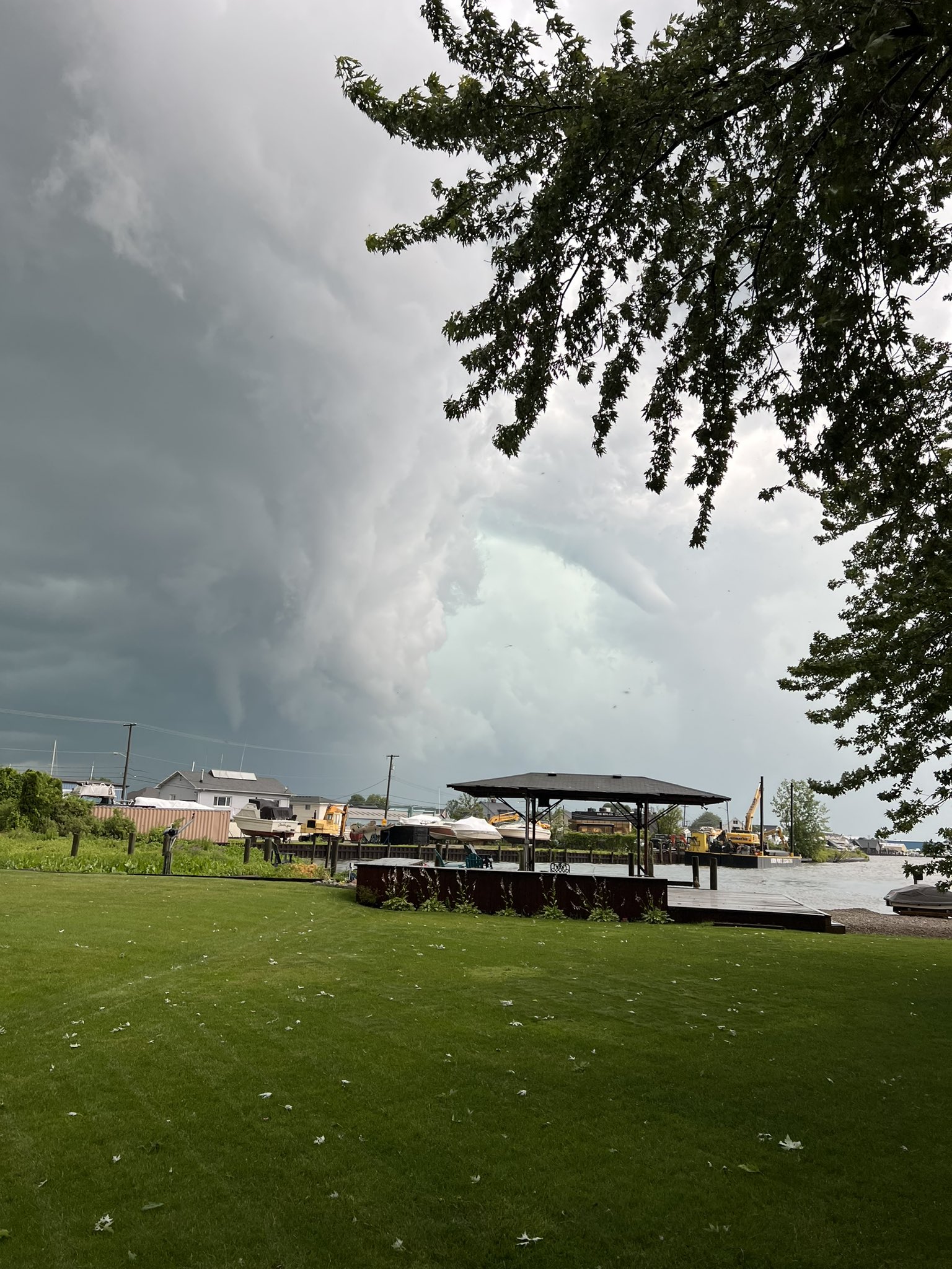
Anchor Bay Credit: Nick LaRosa |
Ann Arbor Credit: Frank Marsik |
Davison Credit: Jeremiah Jacobs |
 |
 |
 |
|
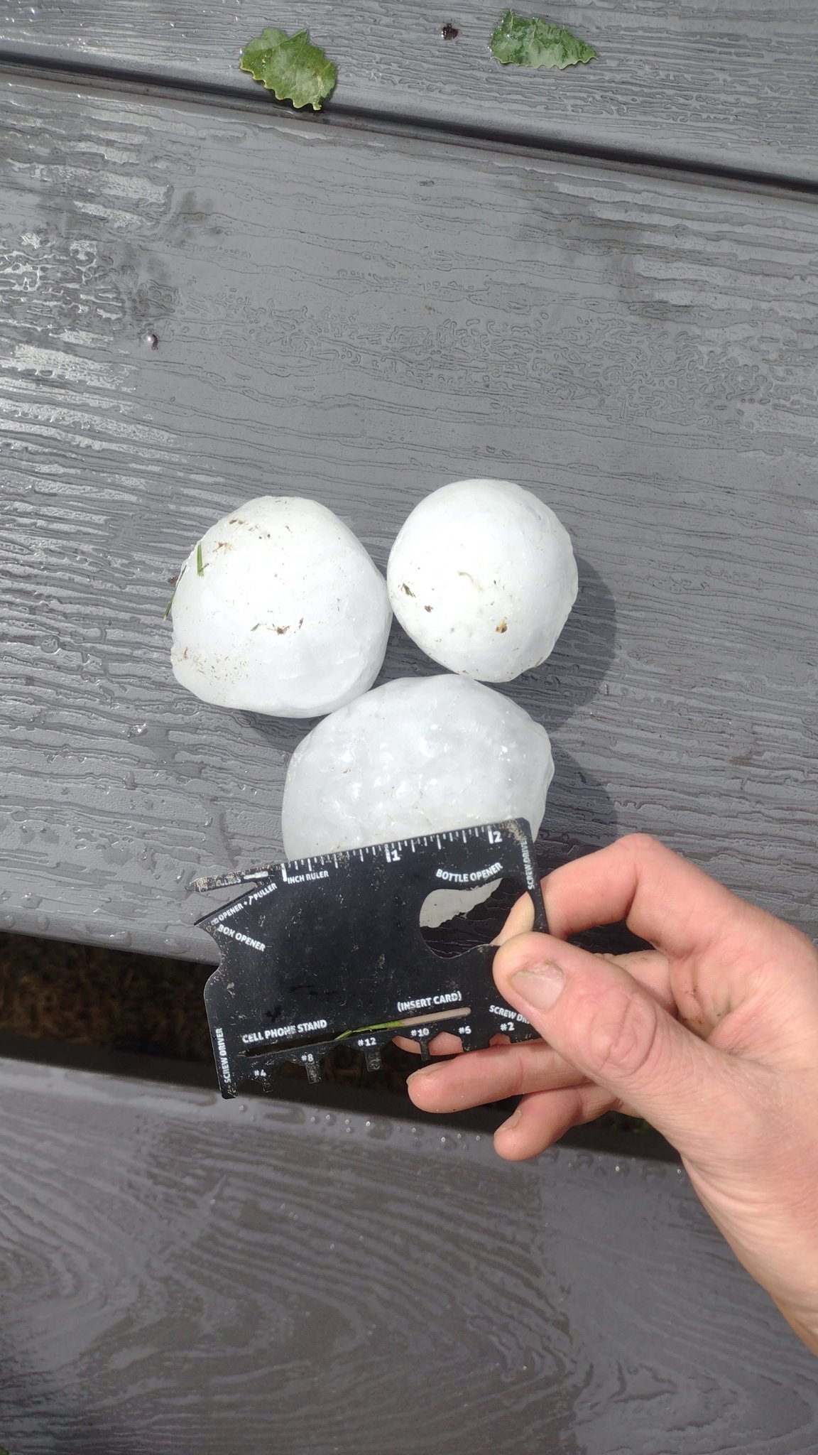
Davison Credit: Dave Bondy |
Davison Credit: Dave Bondy |
Davison Credit: Dave Bondy |
 |
 |
 |
|
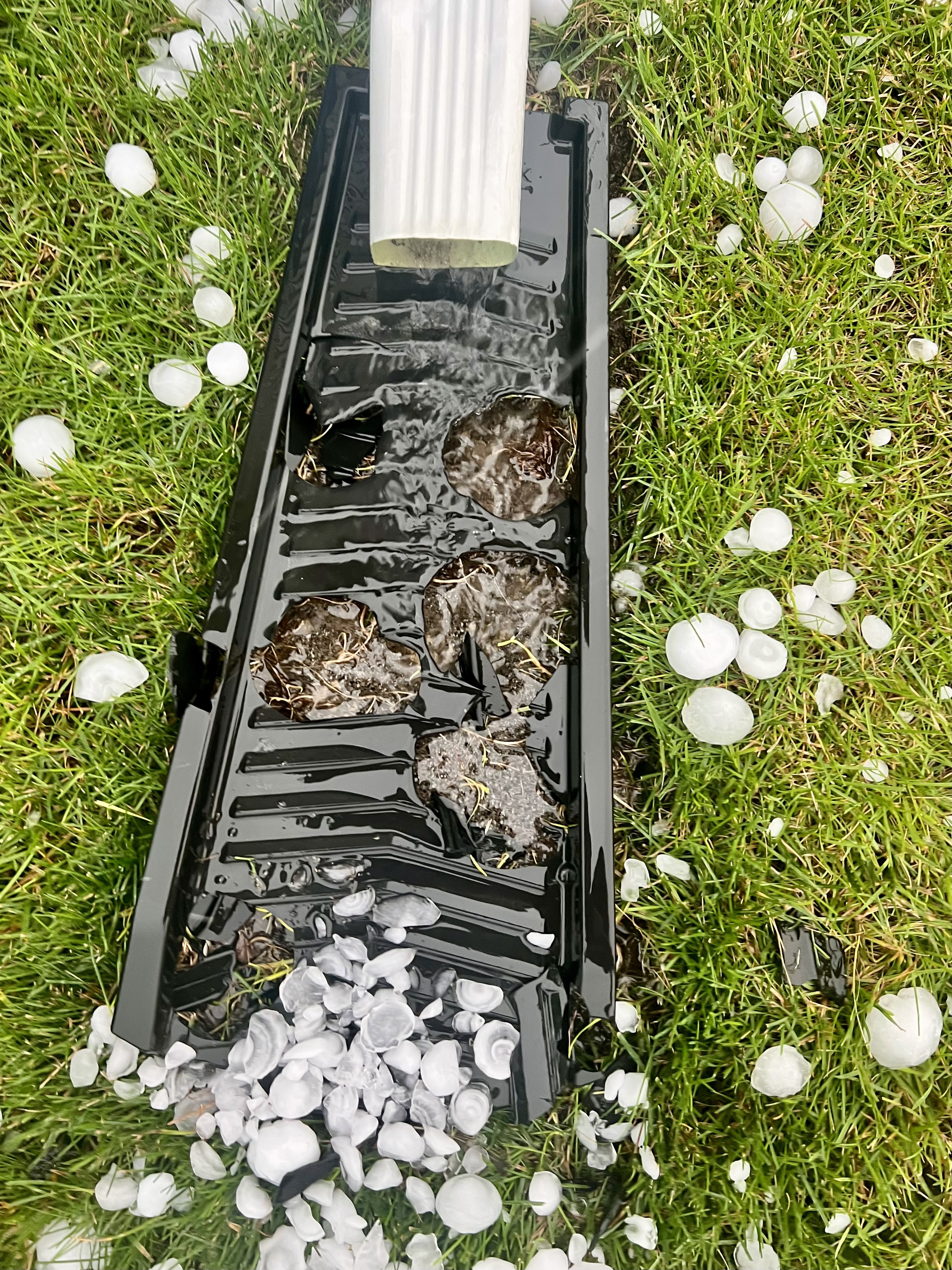
Davison Credit: @TechBoyTroy |
Davison Credit: @TechBoyTroy |
Davison Credit: Ahmad Bajjey |
 |
 |
 |
|
Davison Credit: Brandon Palevich via Ron Hilliard |
Macomb Township Credit: @mort0nhearsawh0 |
Oxford Credit: @itskitten2u |
 |
 |
 |
|
Port Huron Credit: Matt Markham |
St. Clair Shores Credit: David Kozin |
West Bloomfield Credit: Kyle Chudler |
Radar
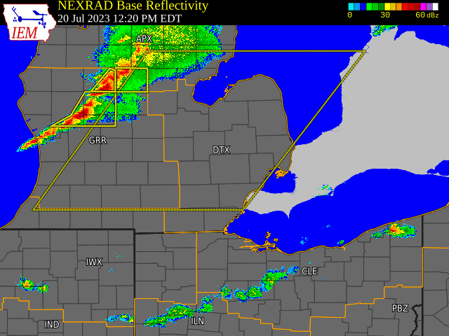
Radar loop courtesy of Iowa Environmental Mesonet (IEM)
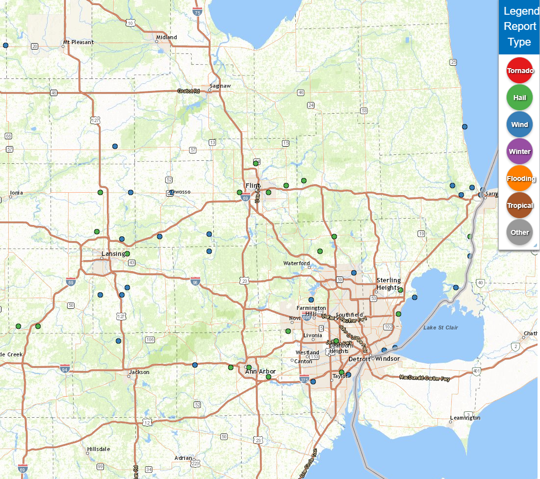
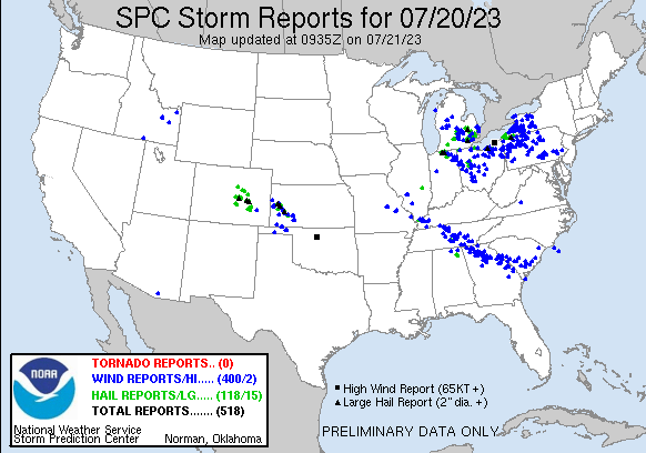
Storm Reports
|
|
|
Map of Local Storm Reports July 20, 2023 |
Severe Weather Local Storm Reports:
Preliminary Local Storm Report...Summary
National Weather Service Detroit/Pontiac MI
824 PM EDT Thu Jul 20 2023

..TIME...   ...EVENT...      ...CITY LOCATION...     ...LAT.LON...
..DATE...   ....MAG....      ..COUNTY LOCATION..ST.. ...SOURCE....
            ..REMARKS..

0220 PM     Tstm Wnd Dmg     1 E Owosso              43.00N  84.16W
07/20/2023                   Shiawassee         MI   Public

            Reports of wires and large trees down two miles south
            of the intersection of 500 Block and Comstock Street.

0223 PM     Hail             5 WSW Flint             43.00N  83.78W
07/20/2023  M0.75 inch       Genesee            MI   Trained Spotter

0233 PM     Hail             Mount Morris            43.12N  83.69W
07/20/2023  M1.00 inch       Genesee            MI   Trained Spotter

            Hail fell in the city of Mount Morris.

0234 PM     Tstm Wnd Dmg     Perry                   42.82N  84.23W
07/20/2023                   Shiawassee         MI   Law Enforcement

            Dispatch reported several power lines downed near 1st
            St and Madison St in Perry. Time estimated based on
            radar.

0237 PM     Hail             Davison                 43.03N  83.52W
07/20/2023  E2.50 inch       Genesee            MI   Public

            Reports of widespread hail damage across Davison.

0239 PM     Hail             Burton                  43.00N  83.62W
07/20/2023  E1.00 inch       Genesee            MI   Public

            Hail estimated from a live video, estimated size of 1
            inch.

0247 PM     Hail             Davison                 43.03N  83.52W
07/20/2023  E1.75 inch       Genesee            MI   Trained Spotter

0247 PM     Tstm Wnd Dmg     Byron                   42.83N  83.95W
07/20/2023                   Shiawassee         MI   Law Enforcement

            Dispatch reported a large tree had fallen on a house in
            Byron. Time estimated based on radar.

0250 PM     Hail             Davison                 43.03N  83.52W
07/20/2023  M2.75 inch       Genesee            MI   Broadcast Media

            Media reports of hail up to baseball size in Davison.

0256 PM     Tstm Wnd Dmg     Cohoctah                42.76N  83.95W
07/20/2023                   Livingston         MI   Law Enforcement

            Numerous trees down across the northern end of
            Livingston County including around Cohoctah.

0257 PM     Hail             5 W Lapeer              43.05N  83.42W
07/20/2023  M1.50 inch       Lapeer             MI   Trained Spotter

0300 PM     Hail             Davison                 43.03N  83.52W
07/20/2023  E2.50 inch       Genesee            MI   Public

0310 PM     Hail             1 NNW Oak               42.39N  83.24W
07/20/2023  E1.50 inch       Wayne              MI   Public

            Reports of hail up to 1.50 inches near Grand River and
            Southfield Road.

0320 PM     Hail             Oxford                  42.82N  83.25W
07/20/2023  M1.25 inch       Oakland            MI   Public

0332 PM     Hail             6 SW Oxford             42.76N  83.33W
07/20/2023  M1.00 inch       Oakland            MI   Trained Spotter

            Quarter size hail reported near the intersection of
            Sashabaw Rd and Seymour Lake Rd.

0336 PM     Tstm Wnd Dmg     1 SW Rochester          42.67N  83.14W
07/20/2023                   Oakland            MI   Trained Spotter

            Two large trees downed near 1st St and Campbell Street.
            Several 8 inch diameter limbs also reported around the
            Rochester area. Time estimated based on radar.

0340 PM     Hail             Saint Clair Shores      42.50N  82.89W
07/20/2023  M1.50 inch       Macomb             MI   Public

            Report of hail up to 1.50 inches at 11 Mile and
            Jefferson Ave.

0340 PM     Tstm Wnd Dmg     2 S Orchard Lake        42.56N  83.38W
07/20/2023                   Oakland            MI   NWS Employee

            Large tree was uprooted and blocking southbound Walnut
            Lake Road at West Bloomfield Lake Rd.

0342 PM     Hail             St. Clair               42.82N  82.49W
07/20/2023  M1.75 inch       St. Clair          MI   Trained Spotter

            Hail fell in the city of St Clair

0345 PM     Tstm Wnd Dmg     2 SSW Chelsea           42.29N  84.03W
07/20/2023                   Washtenaw          MI   Public

            Report of a tree down blocking Cavanaugh Lake Road near
            Conway Road.

0346 PM     Tstm Wnd Gst     1 SSW Saint Clair Haven 42.57N  82.80W
07/20/2023  M52 mph          Macomb             MI   Mesonet

            Measured at Lake St Clair Metropark

0348 PM     Hail             1 WSW Northville        42.43N  83.51W
07/20/2023  M1.00 inch       Wayne              MI   Public

            One inch hail reported near the intersection of 8 Mile
            and Beck.

0350 PM     Waterspout       1 SSE Point Lakeview    42.64N  82.77W
07/20/2023                   LCZ460             MI   Public

            Obsered waterspout offshore east of New Baltimore over
            Anchor Bay.

0353 PM     Tstm Wnd Dmg     1 SE Ruby               43.03N  82.59W
07/20/2023                   St. Clair          MI   Public

            Several trees reported down in Clyde Township. Time
            estimated based on radar.

0355 PM     Tstm Wnd Dmg     Port Huron              42.99N  82.43W
07/20/2023                   St. Clair          MI   Public

            Report of roof damage in downtown Port Huron near the
            intersection of Fort and Beers road.

0355 PM     Tstm Wnd Dmg     Wadhams                 42.99N  82.54W
07/20/2023                   St. Clair          MI   Public

            Report of numerous trees and wires down around the
            Wadhams area.

0356 PM     Tstm Wnd Dmg     3 NW Port Huron         43.02N  82.48W
07/20/2023                   St. Clair          MI   Public

            Report of several trees down near the intersection of
            Oakwood Drive and West Water Drive. Time estimated based
            on radar.

0357 PM     Tstm Wnd Dmg     2 NNE Marine City       42.74N  82.49W
07/20/2023                   St. Clair          MI   Trained Spotter

            Multiple reports of trees down, several with over one
            foot diameter, along and within vicinity of M29.

0404 PM     Hail             Ypsilanti               42.24N  83.62W
07/20/2023  M2.00 inch       Washtenaw          MI   Public

            Report of hail up to 2.00 inches near Benjamin Drive
            and Prospect Road.

0405 PM     Hail             Mount Clemens           42.60N  82.88W
07/20/2023  E1.75 inch       Macomb             MI   Trained Spotter

0406 PM     Tstm Wnd Gst     1 NNE Port Huron        43.01N  82.42W
07/20/2023  M49 mph          St. Clair          MI   C-Man Station

            Measured at Fort Gratiot Light

0407 PM     Hail             5 W Ann Arbor           42.28N  83.83W
07/20/2023  E1.00 inch       Washtenaw          MI   Trained Spotter

0407 PM     Tstm Wnd Gst     1 ESE Lexington         43.27N  82.52W
07/20/2023  M46 mph          LHZ443             MI   Mesonet

            Measured at Lexington Harbor

0410 PM     Tstm Wnd Gst     Pointe aux Tremble      42.61N  82.57W
07/20/2023  M47 mph          St. Clair          MI   Mesonet

0413 PM     Hail             Ann Arbor               42.28N  83.73W
07/20/2023  M1.50 inch       Washtenaw          MI   Trained Spotter

            Report of hail up to ping pong ball size.

0414 PM     Tstm Wnd Gst     Romulus                 42.22N  83.37W
07/20/2023  M62 mph          Wayne              MI   ASOS

            KDTW ASOS measured a 54 knot wind gust at Detroit Metro
            Airport.

0415 PM     Hail             Allen Park              42.26N  83.21W
07/20/2023  M1.00 inch       Wayne              MI   NWS Employee

0417 PM     Tstm Wnd Dmg     1 NE Lincoln Park       42.25N  83.17W
07/20/2023                   Wayne              MI   Public

            Report of a large tree down across Chandler Avenue.

0425 PM     Tstm Wnd Gst     2 SW Grosse Pointe Park 42.35N  82.97W
07/20/2023  M43 mph          Wayne              MI   Mesonet

            Measured at Detroit Yacht Club

0426 PM     Tstm Wnd Gst     2 S Grosse Pointe       42.36N  82.91W
07/20/2023  M57 mph          LCZ460             MI   Mesonet

            Measured at Peche Island Light

0456 PM     Rain             Ann Arbor               42.28N  83.73W
07/20/2023  M1.05 inch       Washtenaw          MI   Co-Op Observer

            Storm total rainfall report of 1.05 inches in SE Ann
            Arbor.

0500 PM     Rain             Garden City             42.33N  83.33W
07/20/2023  M1.25 inch       Wayne              MI   Storm Chaser

            Storm total rainfall report of 1.25 inches.

0500 PM     Rain             Marine City             42.71N  82.50W
07/20/2023  M1.09 inch       St. Clair          MI   Co-Op Observer

            Storm total rainfall report of 1.09 inches.

0500 PM     Rain             Lakeport                43.12N  82.50W
07/20/2023  M1.88 inch       St. Clair          MI   Public

            Storm total rainfall report of 1.875 inches.


&&
 |
|
National Storm Reports for July 20, 2023 |
Environment
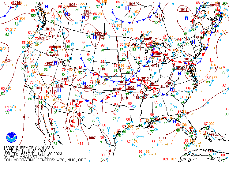
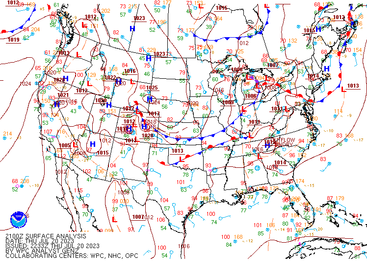
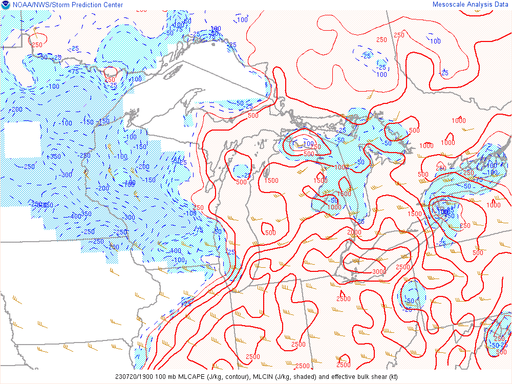
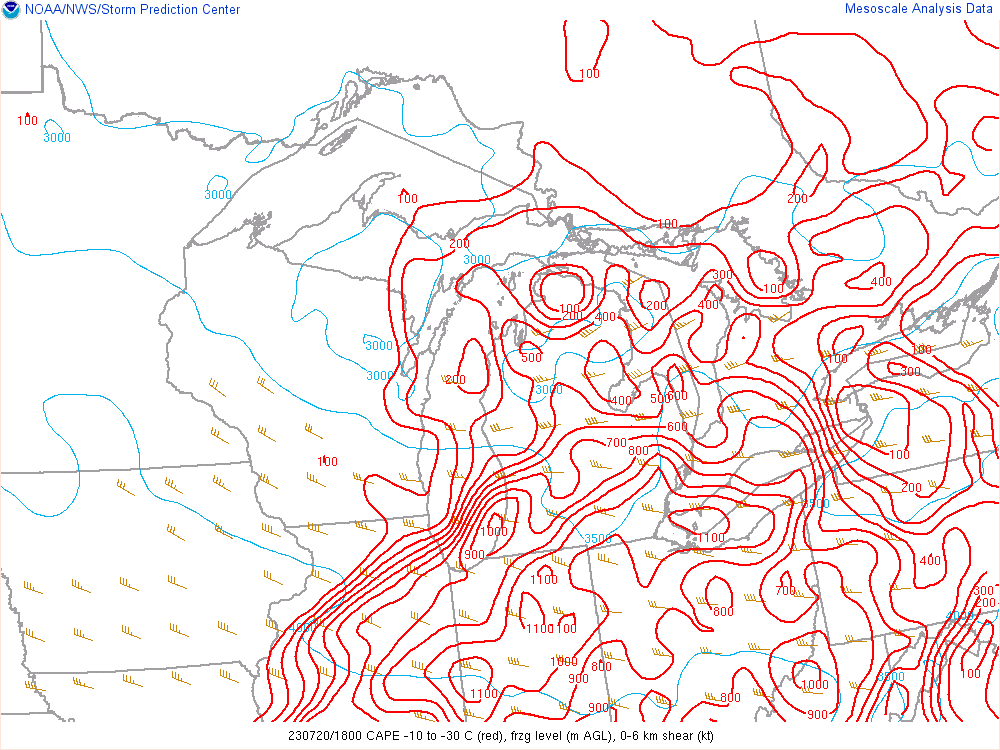
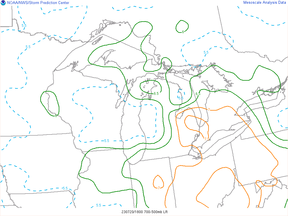
A line of strong to severe storms advanced from northwest to southeast across Lower Michigan on Thursday July 20th ahead of an upper level trough and along a surface cold front. The combination of diurnal heating and low-level moisture advection locally contributed to pre-frontal airmass destabilization early Thursday afternoon which facilitated the development of a few supercells within the southwesterly flow warm sector before the main convective line arrived. A favorable balance of +35 knots of effective bulk shear and mixed-layer convective available potential energy (MLCAPE) exceeding 2000 J/kg supported strong to severe supercellular storms capable of large to significant hail as mid-level lapse rates steepened in excess of 7 C/km. Based on mesoanalysis data, hail layer instability approached 1000 J/kg of CAPE at times which ensured robust updrafts to generate destructive hail. Over Davison, MI where 2.75 inch (Baseball size) hail was reported, upper level radar signatures indicated 60 dBZ reflectivity up to an impressive 34,000 ft above radar level (ARL).
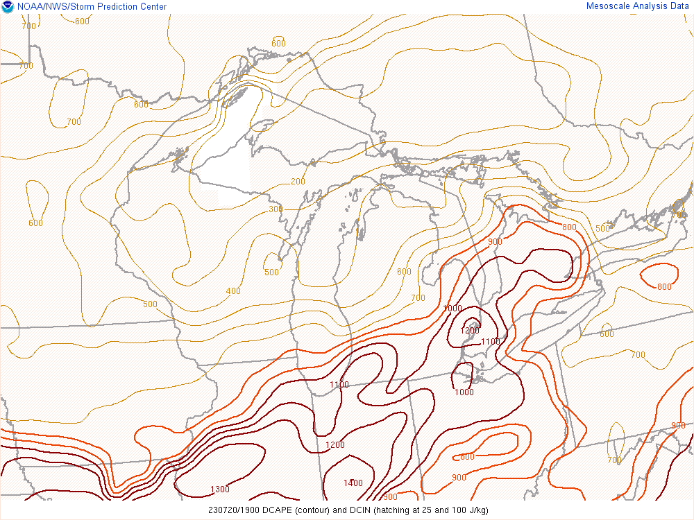
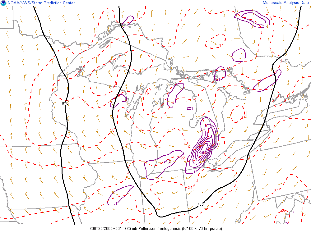
As the line of organized storms crossed into Midland County around 1 PM, organization continued to improve as it fed off the increasingly favorable environment. In addition to the high-end shear and instability, downdraft CAPE exceeded 1000 J/kg helping produce areas of severe wind damage marked by a peak wind report of 62 mph at Detroit Metro Airport. Tornado threat remained relatively low given a lack of directional low-level wind shear, but interactions with the lake breeze boundaries over Lake St. Clair did produce a picturesque funnel cloud an eventually a waterspout over Anchor Bay. Part of the reasoning behind the robust squall line development can be attributed to the strong lift along the front was tied to the FGEN with strong upper-level divergence ensuring dynamic support for convection.
The front and associated convection exited to the southeast by 6 pm with strong wake subsidence quickly eroding clouds leading to clear skies for most areas Thursday evening.
 |
 |
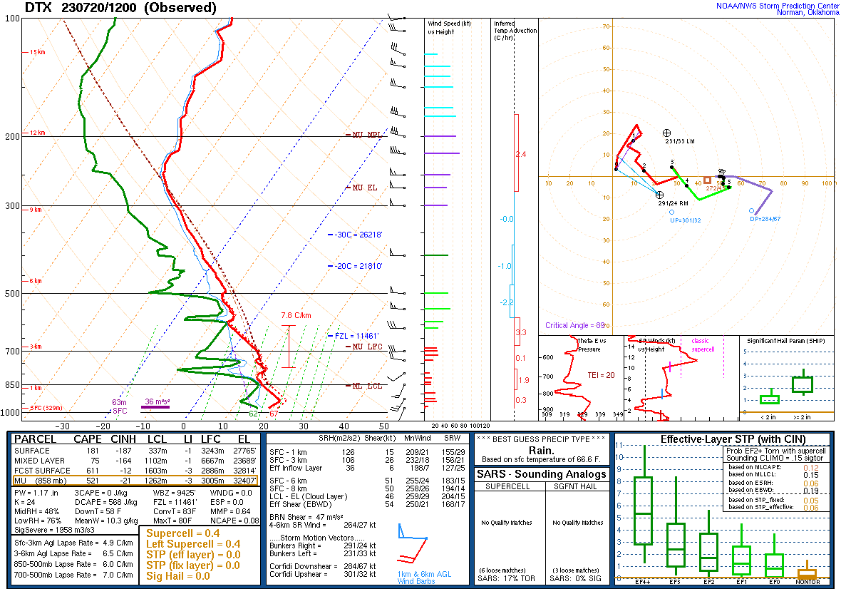 |
| Figure 1: WPC Surface Analysis, valid 1500 UTC 20 Jul 2023 | Figure 2: WPC Surface Analysis, valid 2100 UTC 20 Jul 2023 | Figure 3: DTX Sounding, valid 1200 UTC 20 Jul 2023 |
 |
 |
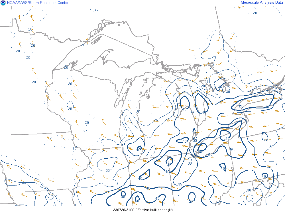 |
| Figure 4: Mixed-Layer CAPE, CIN, and EBS 1900 UTC 20 Jul 2023 | Figure 5: Hail Growth Zone (-10 to -30C) CAPE, valid 1800 UTC 20 Jul 2023 | Figure 6: Effective Wind Shear, valid 2100 UTC 20 Jul 2023 |
 |
 |
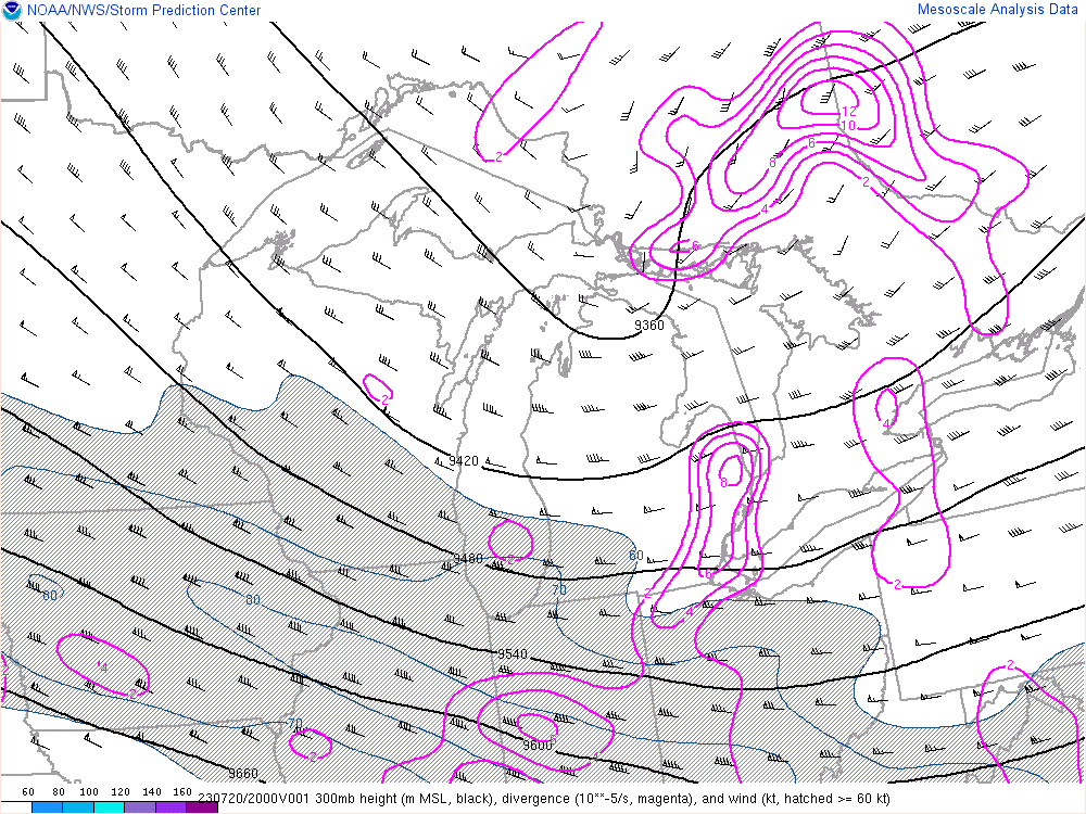 |
| Figure 7: Downdraft CAPE, valid 1900 UTC 20 Jul 2023 | Figure 8: 700-500 mb Lapse Rates valid 1800 UTC 20 Jul 2023 | Figure 9: 300 mb Height, Wind, and Divergence, valid 2000 UTC 20 Jul 2023 |
 |
 |
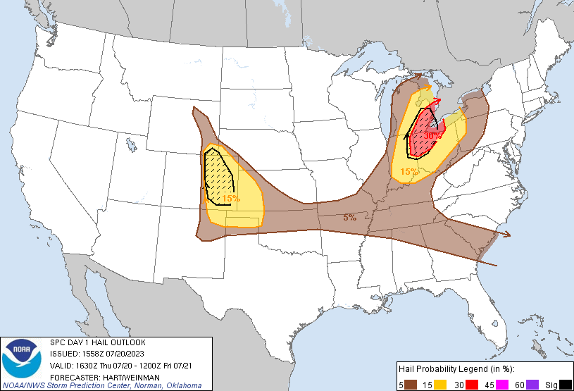 |
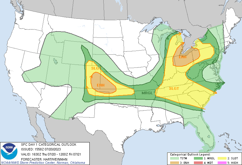
| Figure 10: 925 mb Frontogenesis, valid 2000 UTC 20 Jul 2023 | Figure 11: SPC Day 1 Severe Weather Outlook, valid 1630 UTC 20 Jul 2023 | Figure 12: SPC Day 1 Probabilistic Hail Outlook, valid 1630 UTC 20 Jul 2023 |
 |
Media use of NWS Web News Stories is encouraged! Please acknowledge the NWS as the source of any news information accessed from this site. |
|