Overview
A cold front tracking through southeast Michigan during the afternoon hours of July 21, 2022 led to widespread thunderstorm development and severe weather reports across the area. Initially discrete cells developed just after noon along a north-south oriented instability gradient situated over central MI. These cells moved west to east at 40 mph between approximately 1 PM and 4 PM, growing upscale into a broken line as they progressed. At times these storms exhibited rotation and associated supercellular characteristics, although the main threat with these storms was damaging winds. Several reports of trees and powerlines down as well as a 66 mph wind gust at Detroit Metro Airport were recorded. A second round of storms developed between 4-6 PM as the cold front cleared the area, primarily impacting the extreme eastern portions of the CWA near the Lake Huron shoreline. Storms once again grew upscale quickly and resulted in strong wind gusts.
Photos
 |
 |
|
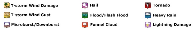
5 SE Columbiaville Credit: Susan Hall |
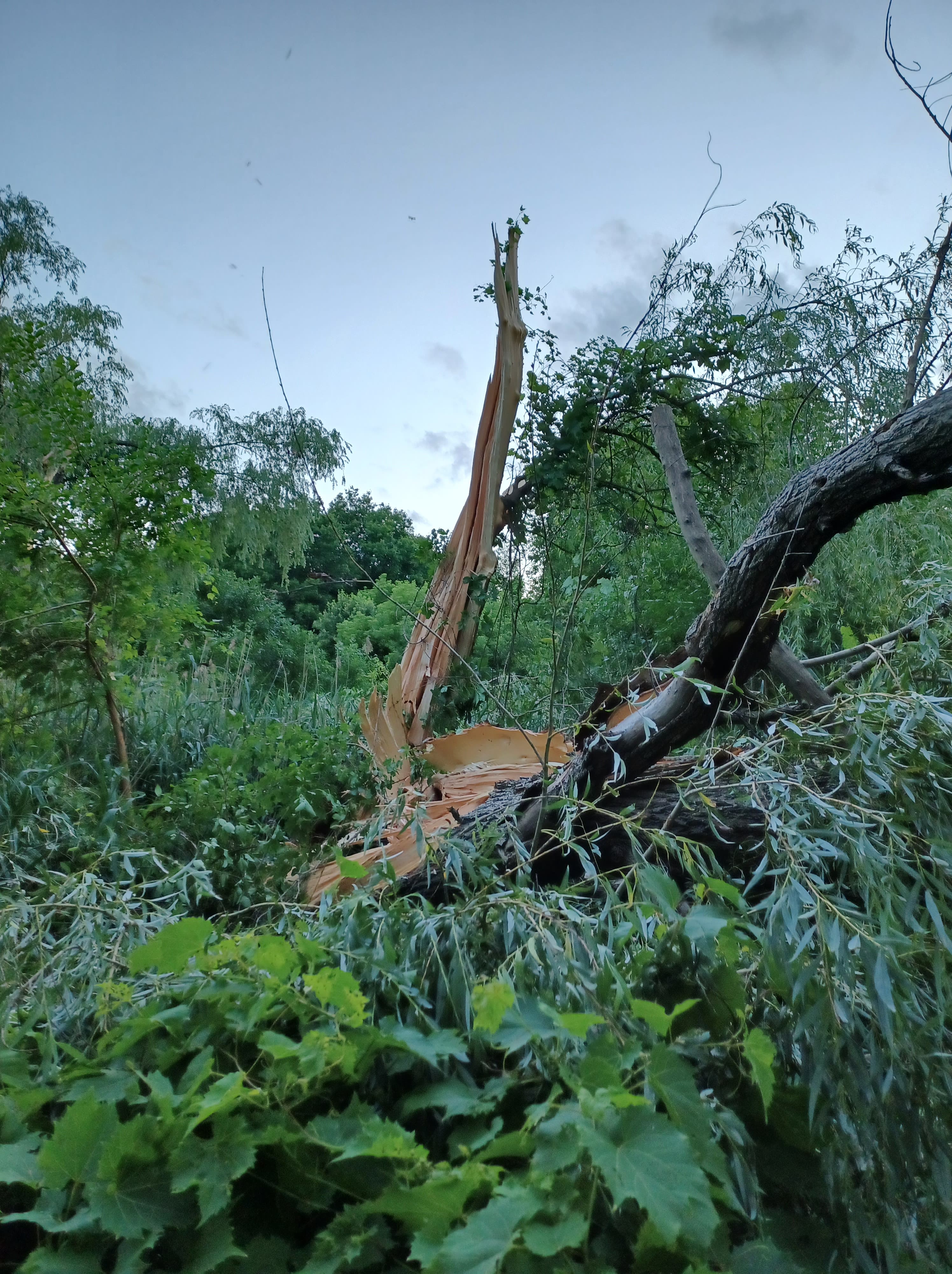
2 S Port Sanilac Credit: Dustie Rennie-Johnson |
Radar
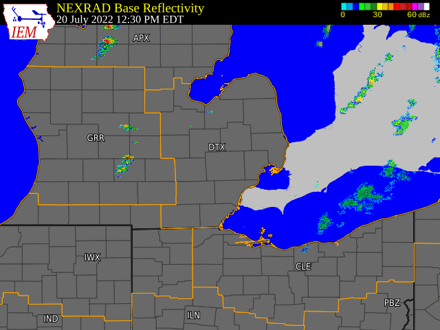  |
|
Click to Enlarge Radar loop courtesy of Iowa Environmental Mesonet (IEM) |
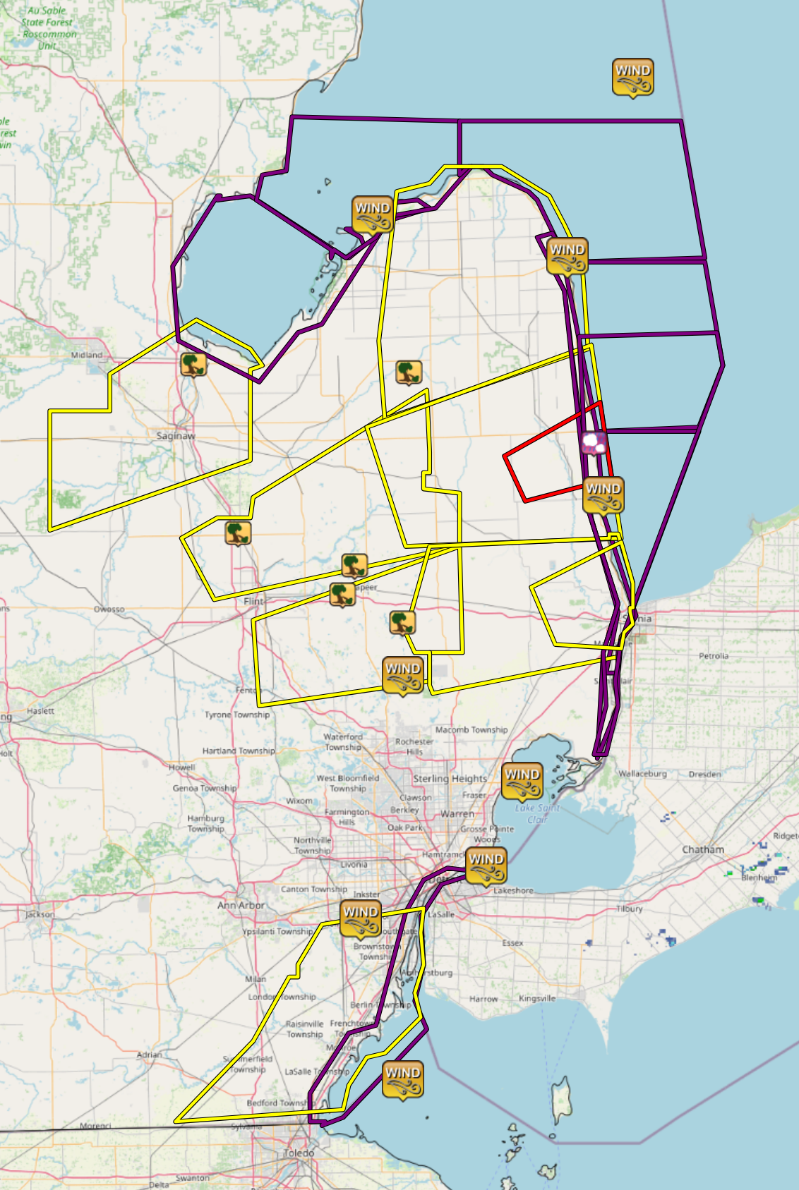
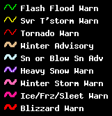
Storm Reports
|
|
|
Map of Local Storm Reports |
Severe Weather Local Storm Reports:
PRELIMINARY LOCAL STORM REPORT...SUMMARY
NATIONAL WEATHER SERVICE DETROIT/PONTIAC MI
413 PM EDT THU JUL 21 2022

..TIME...   ...EVENT...      ...CITY LOCATION...     ...LAT.LON...
..DATE...   ....MAG....      ..COUNTY LOCATION..ST.. ...SOURCE....
            ..REMARKS..

0137 PM     TSTM WND DMG     BAY CITY                43.59N 83.89W
07/20/2022                   BAY                MI   911 CALL CENTER

            DISPATCH REPORTED 20 TO 30 TREES DOWNED ACROSS BAY CITY.
            TIME ESTIMATED FROM RADAR.

0200 PM     TSTM WND DMG     CLIO                    43.18N 83.74W
07/20/2022                   GENESEE            MI   FIRE DEPT/RESCUE

            FIRE DEPARTMENT REPORTED SEVERAL TREES AND WIRES DOWN IN
            AND AROUND CLIO AND VIENNA TOWNHIP. AMATEUR RADIO
            REPORTED SIMILAR DAMAGE IN THE AREA.

0220 PM     TSTM WND DMG     2 S CASS CITY           43.57N 83.17W
07/20/2022                   Tuscola            MI   911 CALL CENTER

            TUSCOLA COUNTY CENTRAL DISPATCH REPORTS 6-7 TREES DOWN
            ACROSS SOUTHERN TUSCOLA COUNTY

0230 PM     TSTM WND DMG     5 SE COLUMBIAVILLE      43.10N 83.35W
07/20/2022                   LAPEER             MI   TRAINED SPOTTER

            LARGE TREE DOWNED - PHOTOS RELAYED VIA SOCIAL MEDIA. TIME
            ESTIMATED VIA RADAR.

0243 PM     TSTM WND DMG     3 WSW LAPEER            43.03N 83.39W
07/20/2022                   LAPEER             MI   911 CALL CENTER

            DIPATCH REPORTED WIRES DOWN SOUTHWEST OF LAPEER. SINGLE
            WIRE DOWN ALSO REPORTED DOWN IN ELBA ALONG WITH A POWER
            OUTAGE REPROTED IN THE CITY OF LAPEER.

0305 PM     TSTM WND DMG     4 WNW DRYDEN            42.96N 83.19W
07/20/2022                   LAPEER             MI   911 CALL CENTER

            POWER OUTAGES REPORTED FROM DOWN TREES AND POWER LINES.
            TIME ESTIMATED ON RADAR.

0308 PM     TSTM WND GST     2 ENE ROMULUS           42.23N 83.33W
07/20/2022  M66.00 MPH       Wayne              MI   ASOS

            DETROIT METROPOLITAN WAYNE COUNTY AIRPORT WIND GUST

0332 PM     HAIL             2 S PORT SANILAC        43.40N 82.55W
07/20/2022  E1.00 INCH       SANILAC            MI   PUBLIC

            A POST ON SOCIAL MEDIA SHOWED HAIL THE SIZE OF QUARTERS.
            TIME ESTIMATED BASED ON RADAR.
 |
|
National Storm Reports for July 20, 2022 |
Environment
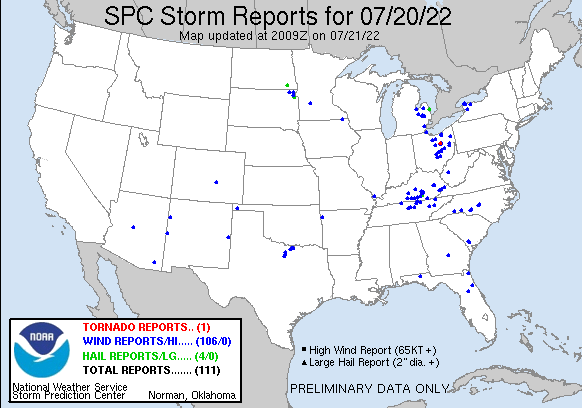
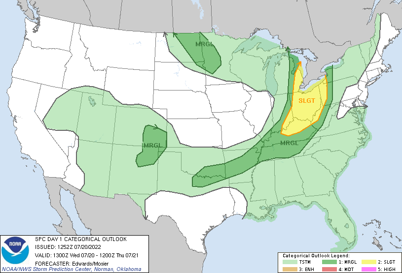
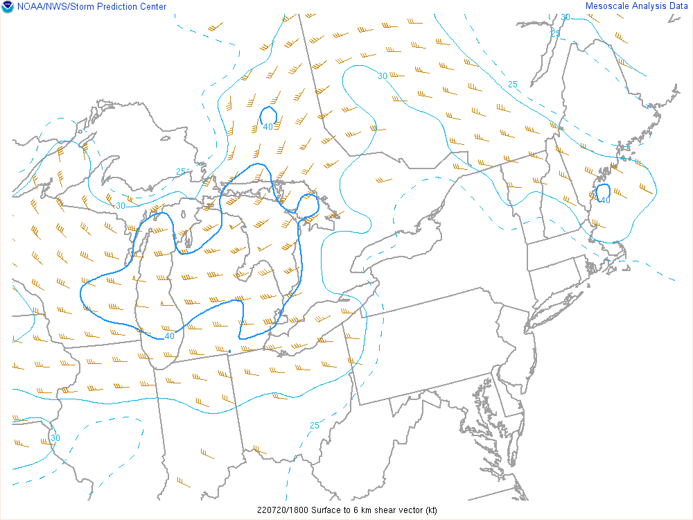
Environmental conditions for this event were supported by a closed upper low over Lake Superior and its attendant north-south oriented cold front progged to track eastward through lower MI during the afternoon hours of July 20th (Figure 1). A Marginal (west of I-75) to Slight (east of I-75) Risk for severe weather was in place across southeast MI per 12z Day 1 SPC Outlook (Figure 2), with all severe weather threats in play. Around 1600z (12pm local time), storms developed along an instability axis/convergence zone just ahead of the cold front, with 1500-2500 J/kg of MLCAPE building downstream (Figure 3). With destabilization expected to continue, a Severe Thunderstorm Watch was issued just prior to 1700z. Discrete cells were favored initially with 40 kt 0-6 km bulk shear vectors oriented nearly orthogonal to the boundary (Figure 4). These cells quickly became organized within the sheared environment and exhibited supercellular characteristics before growing upscale with time.
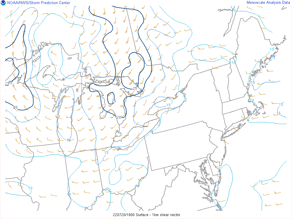
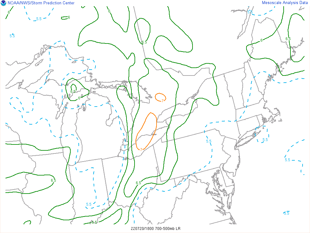
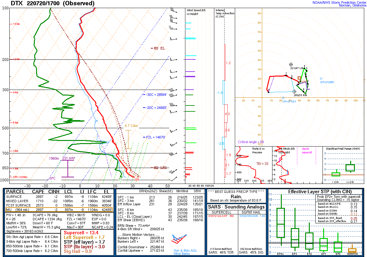
The environment was supportive of all hazards: damaging wind gusts, large hail, and isolated tornadoes. The isolated tornado threat was most favorable toward the eastern edge of the CWA where slightly backed surface winds resulted in pockets of 0-1 km bulk shear around 20 kts (Figure 5). Some cells did exhibit brief periods of low level rotation per radar imagery (Figure 6), however the tornado threat did not materialize. Hail was also a secondary concern, particularly when cells remained in the discrete phase. That said, warming mid-level temperatures contributed to decreasing mid-level lapse rates (Figure 7) in the afternoon and high freezing levels (Figure 8), which hindered large hail development. The primary risk with these storms was damaging wind gusts, particularly as they grew upscale, which resulted in several reports of downed trees and power lines across the CWA (Figure 9). KDTX 17z RAOB (Figure 8) highlights the environmental favorability, depicting dry mid-levels (above 700 mb) atop relatively moist low levels contributing to both precipitation loading and evaporative cooling potential. The wind threat is further illustrated by observed DCAPE ~1300 J/kg and low level lapse rates of 6.6 C/km within the 17z sounding.
Click on the images below to see them expanded.
 |
 |
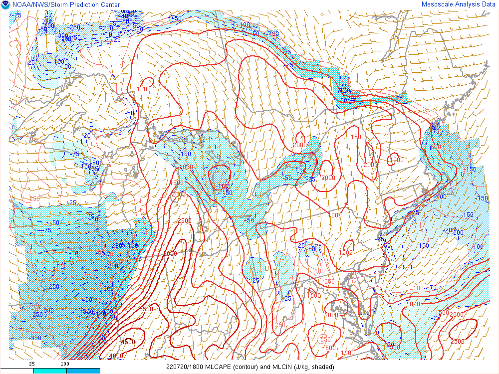 |
| Figure 1: WPC Surface Analysis, valid 1800 UTC 20 July 2022 | Figure 2: SPC Day 1 Outlook, valid 1200 UTC 20 July 2022 | Figure 3: Mixed-layer CAPE, valid 1800 UTC 20 July 2022 |
 |
 |
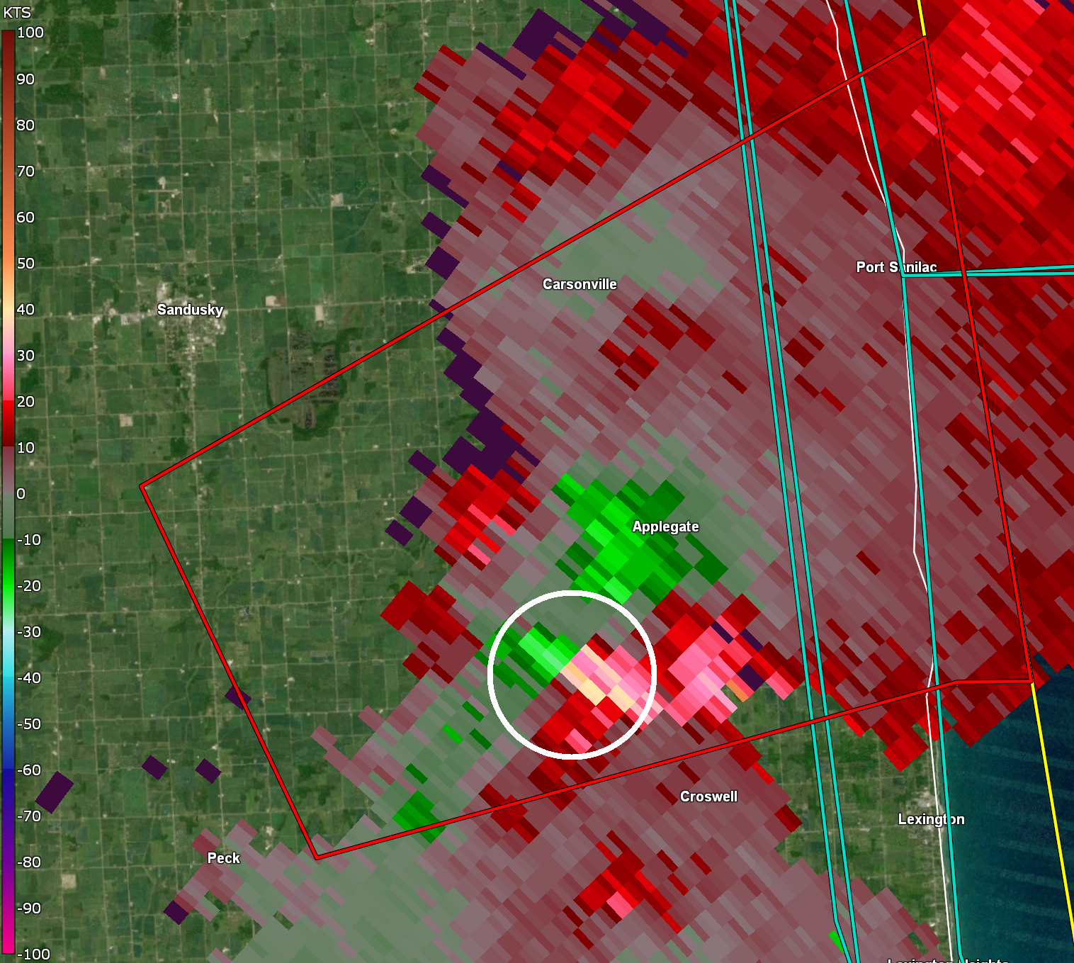 |
| Figure 4: 0-6 km bulk shear, valid 1800 UTC 20 July 2022 | Figure 5: 0-1 km bulk shear, valid 1800 UTC 20 July 2022 | Figure 6: WSR-88D Storm-Relative Velocity, valid 1926 UTC 20 July 2022 |
 |
 |
|
| Figure 7: 700-500mb lapse rates, valid 1800 UTC 20 July 2022 | Figure 8: KDTX observed sounding, valid 1700 UTC 20 July 2022 | Figure 9: SPC Storm Reports, valid 20 July 2022 |
 |
Media use of NWS Web News Stories is encouraged! Please acknowledge the NWS as the source of any news information accessed from this site. |
|