Overview
A well-organized line of strong to severe thunderstorms developed early afternoon on Tuesday, September 7th, along and ahead of an advancing cold front. The line of storms tracked into southeast Michigan just after 2 PM EDT, in which tornado warnings and severe thunderstorm warnings were already in place as the storms crossed into the Detroit/Pontiac CWA. The line remained in tact north of the I-69 corridor; however, became a less organized, multi-cellular cluster as the second round of storms arrived farther south after 5 PM EDT. A majority of the damage was observed north of I-69 in cities such as Midland and Saginaw, where extensive tree damage, power outages, and 1" hail were observed; however, less widespread reports were received south of the I-69 corridor. The line of storms farther south was followed by a swath of high winds, where sustained winds (not associated with thunderstorms) were observed to be 40-50 mph, with gusts up to 60 mph. These winds necessitated the issuance of a High Wind Warning for the middle third of the CWA. The severe weather threat then concluded around 10 PM EDT.
Radar
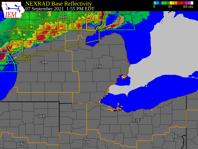  |
|
Click to Enlarge Radar loop courtesy of Iowa Environmental Mesonet (IEM) |
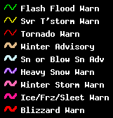
Storm Reports
 |
|
Map of Local Storm Reports |
PRELIMINARY LOCAL STORM REPORT...SUMMARY
NATIONAL WEATHER SERVICE DETROIT/PONTIAC MI
725 PM EDT WED SEP 8 2021

...SEVERE THUNDERSTORM REPORT SUMMARY...

..TIME...   ...EVENT...      ...CITY LOCATION...     ...LAT.LON...
..DATE...   ....MAG....      ..COUNTY LOCATION..ST.. ...SOURCE....
            ..REMARKS..

0315 PM     TSTM WND DMG     2 SSE BOMBAY            43.72N 84.25W
09/07/2021                   MIDLAND            MI   911 CALL CENTER

            DISPATCH REPORTS NUMEROUS TREES AND POWER
            LINES DOWN IN LARKIN TOWNSHIP.

0318 PM     HAIL             4 N MIDLAND             43.68N 84.22W
09/07/2021  E1.00 INCH       MIDLAND            MI   AMATEUR RADIO

            SEVERAL REPORTS OF QUARTER SIZED HAIL FROM
            AMATEUR RADIO.

0331 PM     HAIL             MIDLAND                 43.62N 84.23W
09/07/2021  M1.00 INCH       MIDLAND            MI   PUBLIC

            RELAYED VIA SOCIAL MEDIA IMAGES.

0331 PM     TSTM WND DMG     2 NNW MIDLAND           43.65N 84.25W
09/07/2021                   MIDLAND            MI   PUBLIC

            SEVERAL LARGE TREE BRANCHES DOWN, SOME
            ACROSS ROAD. RELAYED VIA SOCIAL MEDIA
            PHOTOS.

0332 PM     TSTM WND DMG     LINWOOD                 43.74N 83.98W
09/07/2021                   BAY                MI   BROADCAST MEDIA

            MEDIA RELAYED PHOTOS A FEW LARGE TREES DOWN
            IN THE LINWOOD AREA.

0345 PM     TSTM WND DMG     3 ENE BAY CITY          43.61N 83.85W
09/07/2021                   BAY                MI   TRAINED SPOTTER

            6 TO 8 INCH LIMBS DOWN.

0348 PM     TSTM WND GST     5 S AUBURN              43.53N 84.08W
09/07/2021  M63 MPH          SAGINAW            MI   ASOS

            MEASURED AT MBS INTERNATIONAL AIRPORT.

0420 PM     TSTM WND DMG     5 E OWENDALE            43.72N 83.16W
09/07/2021                   HURON              MI   911 CALL CENTER

            DISPATCH REPORTS SEVERAL TREES AND POWER
            LINES DOWN NEAR OWENDALE AND IVANHOE.

0440 PM     MARINE TSTM WIND 1 SSE PORT SANILAC      43.42N 82.54W
09/07/2021  M40 MPH          SANILAC            MI   MESONET

            34KT GUST MEASURED AT PORT SANILAC.

0445 PM     TSTM WND DMG     CARROLLTON              43.46N 83.93W
09/07/2021                   SAGINAW            MI   BROADCAST MEDIA

            MEDIA RELAYED DAMAGE PHOTOS VIA SOCIAL MEDIA
            OF DAMAGE IN CARROLLTON.

0500 PM     TSTM WND GST     2 SSW SAGINAW           43.39N 83.96W
09/07/2021  E60 MPH          SAGINAW            MI   TRAINED SPOTTER

            TRAINED SPOTTER ESTIMATED 60 MPH WINDS. TIME
            ESTIMATED VIA RADAR.

0515 PM     TSTM WND DMG     VASSAR                  43.37N 83.58W
09/07/2021                   TUSCOLA            MI   TRAINED SPOTTER

            TRAINED SPOTTER REPORTS TREES DOWN AND POWER
            OUTAGES AROUND THE CITY OF VASSAR.

0532 PM     TSTM WND DMG     5 NNW SAGINAW           43.48N 83.99W
09/07/2021                   SAGINAW            MI   PUBLIC

            PUBLIC REPORTS OF SEVERAL LARGE DIAMETER
            LIMBS DOWN AS WELL AS A FEW TREES AROUND
            MACKINAW AND TITTABAWSSEE ROADS.

0532 PM     TSTM WND DMG     5 NNW SAGINAW           43.48N 83.99W
09/07/2021                   SAGINAW            MI   PUBLIC

            PUBLIC REPORTS OF SEVERAL LARGE DIAMETER
            LIMBS DOWN AS WELL AS A FEW TREES AROUND
            MACKINAW AND TITTABAWSSEE ROADS. BROADCAST
            MEDIA ALSO RELAYED IMAGES OF LARGE UPROOTED
            TREE AND SEVERAL BRANCHES DOWN IN SAME
            LOCATION.

0800 PM     MARINE TSTM WIND 6 WSW HARSENS ISLAND    42.56N 82.68W
09/07/2021  M39 MPH          ST. CLAIR          MI   MESONET

            34 KNOT GUST MEASURED AT CLUB ISLAND.

0804 PM     TSTM WND DMG     3 NNE HUDSON            41.90N 84.33W
09/07/2021                   LENAWEE            MI   911 CALL CENTER

            DISPATCH REPORTS LARGE BRANCHES AND POWER
            LINES DOWN IN THE CITIES OF ADDISON AND
            HUDSON.

0855 PM     MARINE TSTM WIND 6 WSW HARSENS ISLAND    42.56N 82.68W
09/07/2021  M43 MPH          ST. CLAIR          MI   MESONET

            MEASURED AT CLUB ISLAND.

0920 PM     MARINE TSTM WIND 5 SW DOWNTOWN DETROIT   42.28N 83.13W
09/07/2021  M41 MPH          WAYNE              MI   MESONET

            MEASURED VIA SHIAWASSEE ST MESONET.

0945 PM     MARINE TSTM WIND 6 WSW HARSENS ISLAND    42.56N 82.68W
09/07/2021  M45 MPH          ST. CLAIR          MI   MESONET

            MEASURED AT CLUB ISLAND.
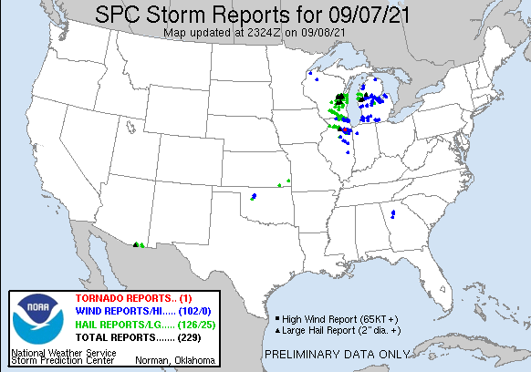 |
|
National Storm Reports for September 7, 2021 |
Environment
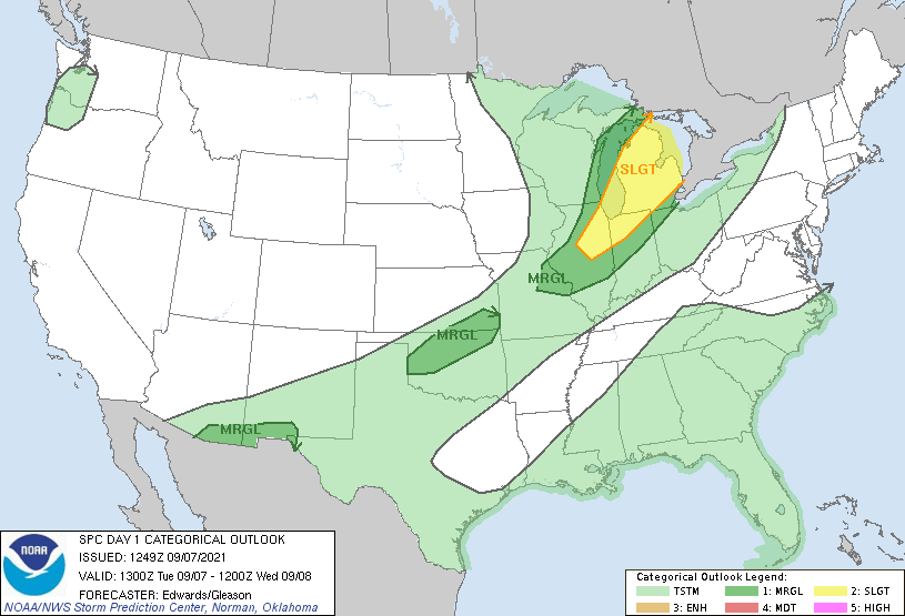
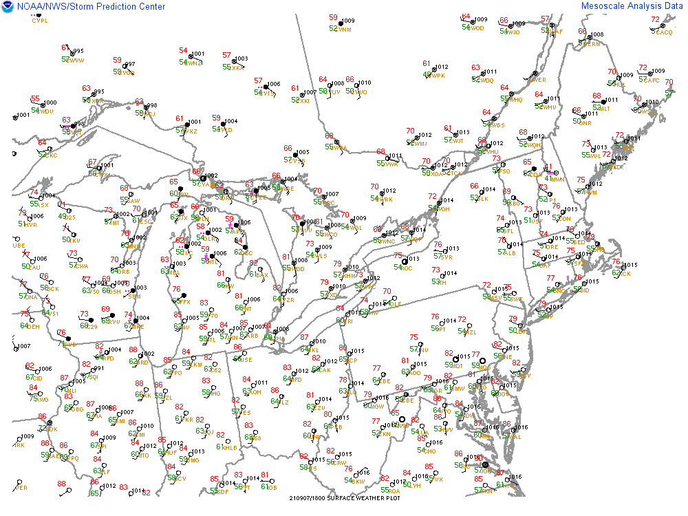
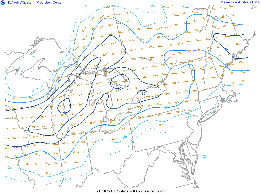
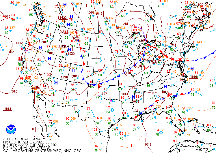
Severe weather potential was outlined by the Storm Prediction Center in the Day 3 Outlook, with an upgrade to Slight Risk by Day 1 (Figure 1). As of late morning September 7th, southwest flow had advected warmer/more humid air into southeast Michigan, as evidenced by dewpoints in the mid-60s by early afternoon (Figure 2). MLCAPE had increased to around 1500 J/kg at peak daytime heating, with the best instability axis setting up in the Tri-Cities region (Figure 3). Similar to the instability, the best wind shear was located across the northern sections of the CWA; however, widespread 40+ kt 0-6 km bulk shear was present across all of southeast MI (Figure 4). Strong wind shear in the wake of an advancing cold front, depicted in Figure 5, led to thunderstorms developing in a linear mode, with damaging wind gusts of 60 mph being the primary threat as a result.
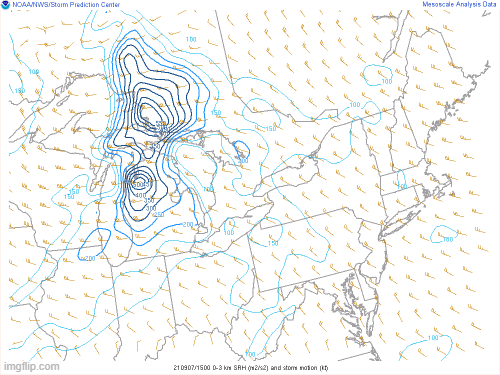
Large hail was certainly possible with these storms, as mid-level lapse rates of 7-7.5 C/km were observed across the CWA (Figure 6); however, the lack of discrete storm development was a limiting factor, and thus only sporadic reports of 1" hail were observed. The lack of discrete supercells also hampered tornadic development, despite 0-3 km SRH in the 150-300 m2/s2 range across portions of the CWA (Figure 7). That said, some embedded storms did exhibit low- and mid-level rotation which prompted the issuance of tornado warnings.
Overall, the severe weather threat lasted from approximately 2 to 10 PM EDT as a well-organized line of strong to severe thunderstorms tracked east-southeast across southeast Michigan. Throughout the afternoon/evening, storms disorganized into more of a cluster, with a lessened widespread severe threat. Across the Detroit/Pontiac CWA, the main impacts were downed trees and power lines due to damaging wind gusts. The majority of the damage was observed north of I-69, with numerous reports from the cities of Midland and Saginaw.
Following the main line of thunderstorms, a short-fused High Wind Warning was issued to account for a swath of strong winds in the Detroit Metro vicinity that developed in the trailing stratiform precipitation region (lasting between approximately 9 and 10 PM). Observed sustained winds of 40-50 mph and gusts to 60 mph were observed in this region. These winds were likely a combination of evaporative cooling and downward motion in the wake of larger-scale subsidence due to the low-level jet. Additional downed trees and power lines were observed, with multiple trained spotters reporting power flashes due to these non-thunderstorm winds.
Click on the images below to see them expanded.
 |
 |
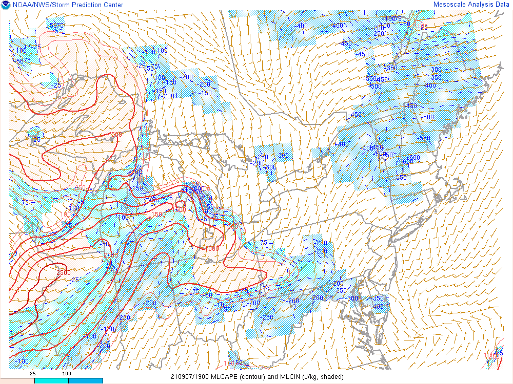 |
| Figure 1. SPC Day 1 Outlook, valid 13 UTC 07 Sep 2021. | Figure 2. Surface dewpoint valid 1800 UTC 07 Sep 2021. | Figure 3. MLCAPE valid 1900 UTC 07 Sep 2021. |
 |
 |
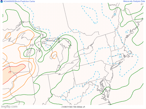 |
| Figure 4. 0-6 km bulk shear valid 2100 UTC 07 Sept 2021. | Figure 5. WPC surface analysis valid 2100 UTC. | Figure 6. 2-6 km AGL layer max lapse rates valid 20 UTC 12 Sep 2021. |
 |
||
| Figure 7. 0-3 km SRH valid 1500 UTC 07 Sep to 0300 UTC 07 Sep 2021. |
 |
Media use of NWS Web News Stories is encouraged! Please acknowledge the NWS as the source of any news information accessed from this site. |
|

