Overview
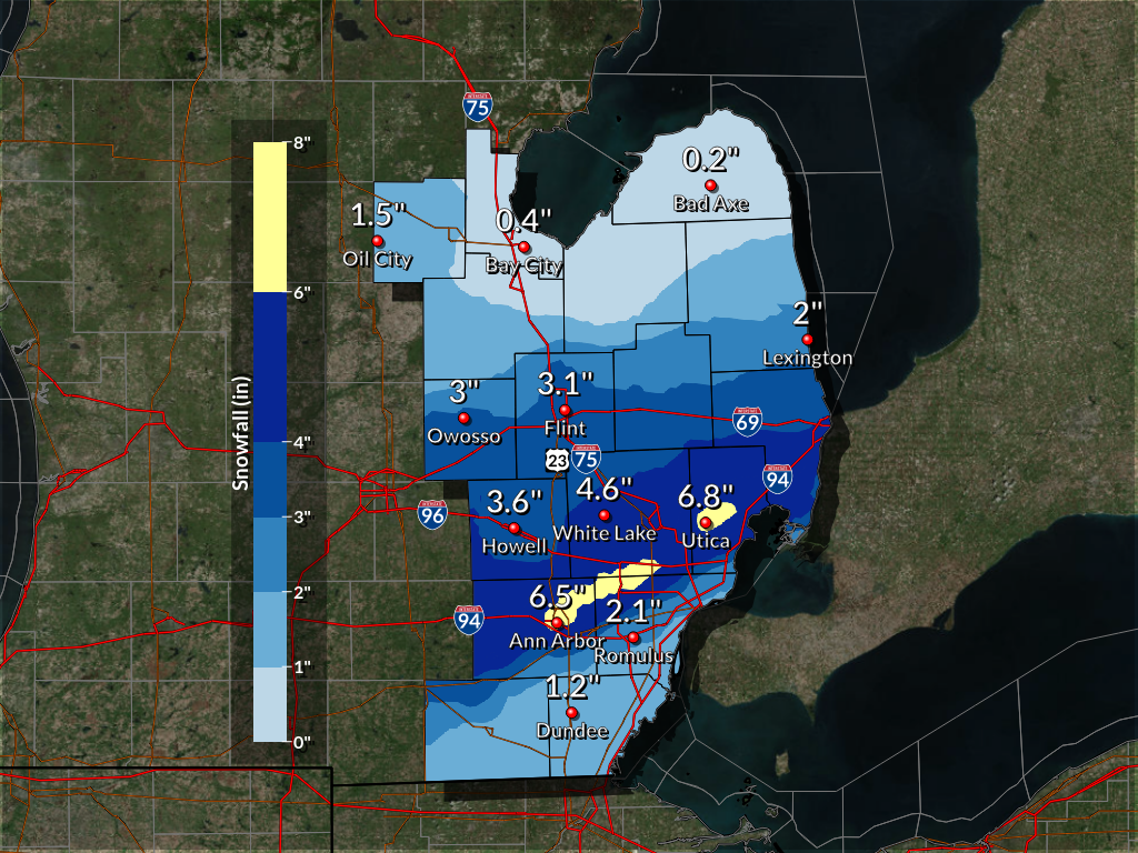
An upper level wave brought overachieving snowfall amounts to southern portions of Southeast Michigan Sunday afternoon and overnight into Monday morning. This convective snow event impacted Ann Arbor and up through most of metro Detroit, along with southern Oakland County where 3 to 6 inches fell. The bulk of the snow occurred Sunday afternoon into the evening where peak intensities likely reached two inches per hour. The snow intensified along the nose of a 130 kt mid-level jet and the lead edge of a mid-level positive potential vorticity feature. Satellite apperance also suggested that a gravity wave was highly influential. This type of event is always a challenge to forecast where exact snowfall amounts will fall given that certain factors have to come into play at the same time.
Snowfall Totals
 |
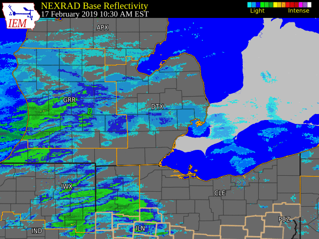
Radar
 |
|
Radar loop from 10:30 AM Sunday through 6 AM Monday (Loop courtesy of Iowa Environmental Mesonet) |
Storm Reports
Public Information Statement...Storm Totals
National Weather Service Detroit/Pontiac MI
903 AM EST Mon Feb 18 2019


STORM TOTAL SNOW REPORTS

Location                  Snowfall     Duration
                          (Inches)      (Hours)        Lat       Lon

...Genesee County...
   4 N Burton              M   3.1           24     43.05N    83.62W
   Flint                   M   3.1           18     43.02N    83.69W

...Lenawee County...
   2 WNW Tipton            M   3.1           24     42.03N    84.10W

...Livingston County...
   1 NE Howell             E   3.6           14     42.62N    83.92W
   Pinckney                M   4.2           15     42.45N    83.95W

...Macomb County...
   4 NNW Richmond          M   3.8           24     42.86N    82.78W
   Warren                  M   3.8           17     42.49N    83.03W
   Sterling Heights        M   4.0           12     42.58N    83.03W
   2 E Utica               M   5.0           24     42.63N    82.98W
   Shelby Township         M   6.8           17     42.67N    83.03W

...Midland County...
   Oil City                M   1.5           24     43.61N    84.59W

...Monroe County...
   Dundee                  M   1.2           24     41.96N    83.66W

...Oakland County...
   Troy                    M   3.8           17     42.58N    83.14W
   Lake Orion              M   4.2           24     42.78N    83.24W
   4 E White Lake          M   4.6           18     42.65N    83.43W
   Troy                    M   4.7           17     42.58N    83.14W
   2 NNE Wixom             M   5.4           13     42.55N    83.52W
   Farmington              M   5.6           24     42.46N    83.38W
   Berkley                 M   6.2         16.5     42.50N    83.19W

...Saginaw County...
   Chesaning               M   1.7           24     43.18N    84.12W

...Sanilac County...
   Lexington               M   2.0           24     43.27N    82.53W

...Shiawassee County...
   Owosso                  M   3.0           24     43.00N    84.18W

...Washtenaw County...
   4 SW Saline             M   3.0           24     42.13N    83.84W
   Manchester              M   5.0           24     42.15N    84.04W
   Ann Arbor               M   6.5           24     42.28N    83.73W

...Wayne County...
   Romulus                 M   2.1           18     42.22N    83.37W
   Garden City             M   4.0           13     42.33N    83.33W
   Northville              M   5.5           10     42.44N    83.49W


M = Measured
E = Estimated
 |
Media use of NWS Web News Stories is encouraged! Please acknowledge the NWS as the source of any news information accessed from this site. |
|

