| Overview | Radar | Additional Resources |
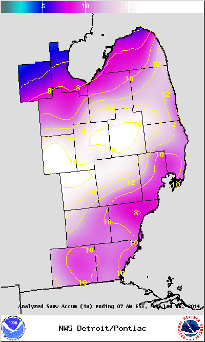
The new year has certainly started off as an active one across Southeast Michigan with this latest winter storm dumping more than a foot of snow across much of the area. Snowfall totals, along with how this winter storm affected other nearby areas can be found below.
So how did this winter storm stack up against other storms in the past? Detroit came in with 10.6 inches, which does just crack the top 25 list and comes in at #24 on the list (records since 1880). Flint received 17.1 inches and put them at the 3rd highest snowfall (records since 1921). Out of the three official climate sites, Saginaw was the only site to not make the top 25 list with this winter storm, but still saw 8.8 inches of snow. At the National Weather Service office in White Lake, while not an official climate site, saw 14.6 inches of snow breaking the record, however records only go back to November 1995. For more details and to see the full lists, click here.
Back to top
|
|
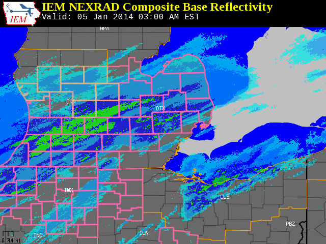
| Radar loop courtesy of Iowa Environmental Mesonet (IEM). Pink outlined counties indicate Winter Storm Warnings and peach outlined coutnies indicate Winter Weather Advisories. |
PUBLIC INFORMATION STATEMENT...STORM TOTALS
NATIONAL WEATHER SERVICE DETROIT/PONTIAC MI
833 PM EST MON JAN 6 2014
STORM TOTAL SNOW REPORTS
LOCATION SNOWFALL DURATION
(INCHES) (HOURS) LAT LON
...BAY COUNTY...
PINCONNING M 5.0 30 43.86N 83.96W
NE BAY CITY M 7.0 30 43.59N 83.89W
...GENESEE COUNTY...
GOODRICH M 11.8 30 42.92N 83.51W
4 N BURTON M 13.2 30 43.05N 83.62W
1 SE GRAND BLANC M 13.9 30 42.92N 83.60W
FLUSHING M 14.5 30 43.06N 83.84W
LINDEN M 16.0 30 42.82N 83.78W
FLINT M 17.1 30 43.02N 83.69W
OTISVILLE M 17.1 30 43.17N 83.52W
2 W SWARTZ CREEK M 18.0 30 42.96N 83.87W
...HURON COUNTY...
PORT AUSTIN M 5.0 30 44.04N 83.00W
BAD AXE M 6.2 30 43.80N 83.00W
GRINDSTONE CITY M 7.5 30 44.05N 82.90W
PORT HOPE M 13.4 30 43.94N 82.72W
...LAPEER COUNTY...
LUM M 14.0 30 43.10N 83.15W
LUM M 14.0 30 43.10N 83.15W
4 W LAPEER M 16.5 30 43.05N 83.40W
NORTH BRANCH M 17.0 30 43.23N 83.19W
...LENAWEE COUNTY...
6 ENE ADRIAN M 8.0 30 41.93N 83.94W
ADRIAN M 8.0 12 41.90N 84.04W
2 WNW TIPTON M 8.9 30 42.03N 84.10W
MORENCI M 12.0 30 41.72N 84.22W
...LIVINGSTON COUNTY...
3 NW PINCKNEY M 11.7 30 42.49N 83.99W
WHITMORE LAKE M 13.0 30 42.43N 83.75W
HOWELL M 14.0 30 42.61N 83.94W
HOWELL M 15.9 30 42.61N 83.94W
2 W FOWLERVILLE M 17.5 30 42.66N 84.11W
...MACOMB COUNTY...
MOUNT CLEMENS M 6.5 24 42.60N 82.88W
CENTER LINE M 7.5 30 42.48N 83.03W
4 NNW RICHMOND M 8.5 30 42.86N 82.78W
SSE NEW BALTIMORE M 9.8 30 42.68N 82.74W
UTICA M 10.0 30 42.63N 83.02W
1 NNW UTICA M 10.5 30 42.64N 83.03W
ARMADA M 11.0 30 42.84N 82.88W
SHELBY TOWNSHIP M 11.0 30 42.67N 83.03W
...MIDLAND COUNTY...
2 ENE MIDLAND M 5.2 30 43.63N 84.19W
MIDLAND M 6.0 30 43.62N 84.23W
...MONROE COUNTY...
3 SE NEWPORT M 8.6 30 41.97N 83.27W
MONROE M 8.9 30 41.92N 83.39W
4 SSE NEWPORT M 9.6 30 41.95N 83.28W
MONROE M 9.8 30 41.92N 83.39W
DUNDEE M 10.0 30 41.96N 83.66W
TEMPERANCE M 11.0 M 41.77N 83.57W
CARLETON M 13.0 30 42.06N 83.39W
...OAKLAND COUNTY...
FARMINGTON M 6.7 30 42.46N 83.38W
2 N FERNDALE M 7.1 30 42.49N 83.13W
FARMINGTON HILLS M 8.1 30 42.49N 83.38W
3 SW BLOOMFIELD HILLS M 8.5 30 42.55N 83.29W
2 SE ROYAL OAK M 8.8 30 42.49N 83.13W
E WHITE LAKE M 9.9 30 42.65N 83.50W
5 N ROCHESTER M 11.1 30 42.76N 83.12W
CLARKSTON M 12.0 30 42.74N 83.42W
4 SSE LAKE ORION M 12.9 30 42.73N 83.21W
FARMINGTON HILLS M 13.2 30 42.49N 83.38W
WATERFORD M 14.5 30 42.66N 83.39W
4 E WHITE LAKE M 14.6 30 42.65N 83.43W
CLARKSTON M 15.3 30 42.74N 83.42W
HOLLY M 15.9 34 42.80N 83.62W
...SAGINAW COUNTY...
5 S MERRILL M 6.8 30 43.34N 84.34W
FREELAND M 8.3 30 43.52N 84.12W
3 NW SAGINAW M 8.4 30 43.45N 83.99W
2 E FREELAND M 8.8 30 43.52N 84.08W
SAGINAW M 8.8 30 43.42N 83.95W
BRIDGEPORT M 9.3 30 43.38N 83.88W
HEMLOCK M 10.5 30 43.42N 84.23W
3 ESE BIRCH RUN M 11.0 24 43.23N 83.74W
...SANILAC COUNTY...
LEXINGTON M 9.7 30 43.27N 82.53W
LEXINGTON M 12.0 30 43.27N 82.53W
SANDUSKY M 13.0 30 43.42N 82.83W
2 W PECK M 16.0 30 43.26N 82.86W
...SHIAWASSEE COUNTY...
CORUNNA M 16.4 30 42.98N 84.12W
OWOSSO M 18.7 30 43.00N 84.18W
...ST. CLAIR COUNTY...
3 E RICHMOND M 9.0 30 42.81N 82.70W
2 W PORT HURON M 10.6 30 42.99N 82.47W
ALGONAC M 10.6 30 42.62N 82.53W
GOODELLS M 11.0 30 42.98N 82.68W
FORT GRATIOT M 13.0 M 43.01N 82.43W
...TUSCOLA COUNTY...
CARO M 9.9 30 43.49N 83.40W
3 E DEFORD M 14.0 30 43.52N 83.13W
MILLINGTON M 16.0 30 43.28N 83.53W
...WASHTENAW COUNTY...
MILAN M 8.0 30 42.09N 83.68W
CHELSEA M 9.5 30 42.31N 84.02W
2 WNW ANN ARBOR M 10.0 30 42.29N 83.77W
SALINE M 10.2 30 42.18N 83.78W
SE ANN ARBOR M 10.3 30 42.28N 83.73W
ANN ARBOR M 10.4 30 42.28N 83.73W
YPSILANTI M 10.5 30 42.24N 83.62W
YPSILANTI M 10.5 30 42.24N 83.62W
DEXTER M 11.7 30 42.33N 83.88W
ENE DEXTER M 12.0 30 42.33N 83.88W
CHELSEA M 14.0 30 42.31N 84.02W
...WAYNE COUNTY...
ALLEN PARK M 7.5 30 42.26N 83.21W
GROSSE POINTE M 7.6 30 42.39N 82.91W
4 NE DEARBORN M 7.8 30 42.35N 83.16W
DETROIT M 7.8 30 42.38N 83.11W
LIVONIA M 8.0 30 42.40N 83.37W
2 NNW LIVONIA M 8.4 30 42.42N 83.39W
N LIVONIA M 8.4 30 42.40N 83.37W
GARDEN CITY M 9.4 M 42.33N 83.33W
BROWNSTOWN TOWNSHIP M 9.5 30 42.15N 83.26W
WYANDOTTE M 9.9 30 42.21N 83.16W
RIVERVIEW M 10.5 30 42.17N 83.19W
ROMULUS M 10.6 30 42.22N 83.37W
M = MEASURED
E = ESTIMATED
Back to top
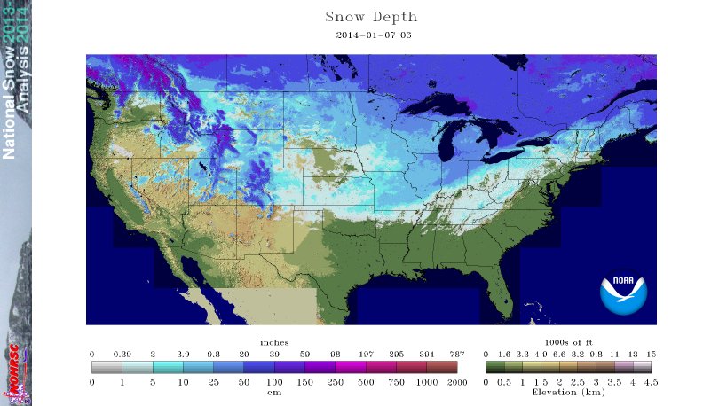
Current snow depth across the Nation as of January 7, 14.
Various summaries of the winter storm from nearby NWS offices can be found by clicking on the following: