| HURON | 06/08/53 | 10:00 PM | Tornado | N/A | 0 | 0 | 0 | 0 |
| HURON | 07/04/74 | 2:00 PM | Tornado | 2 | 0 | 0 | 25000 | 0 |
| HURON | 06/15/75 | 2:40 PM | Tornado | 1 | 0 | 0 | 3000 | 0 |
| HURON | 06/15/75 | 3:00 PM | Tornado | 0 | 0 | 0 | 3000 | 0 |
| HURON | 07/02/75 | 6:45 PM | Tornado | 0 | 0 | 0 | 0 | 0 |
| HURON | 06/12/84 | 6:50 PM | Tornado | 3 | 0 | 0 | 2500000 | N/A |
| HURON | 05/28/91 | 6:10 PM | Tornado | 1 | 0 | 0 | 3000 | 0 |
| HURON | 06/17/92 | 5:37 PM | Tornado | 0 | 0 | 0 | 25000 | 0 |
| HURON | 05/12/00 | 5:50 PM | Tornado | 1 | 0 | 0 | 60000 | 0 |
| HURON | 08/19/01 | 11:00 AM | Tornado | 0 | 0 | 2 | 5000 | 0 |
| HURON | 06/13/04 | 5:00 PM | Tornado | 1 | 0 | 0 | 25000 | 0 |
| HURON | 10/19/2007 | 1:26 AM | Tornado | 1 | 0 | 0 | 250000 | 0 |
| HURON | 7/18/2010 | 9:11 PM | Tornado | 0 | 0 | 0 | 75000 | 0 |
| HURON | 8/2/2015 | 5:39 PM | Tornado | 1 | 0 | 0 | 50000 | 0 |
| HURON | 11/6/2015 | 6:46 AM | Tornado | 0 | 0 | 0 | 15000 | 0 |
| HURON | 6/26/2021 | 4:49 PM | Tornado | 2 | 0 | 6 | 1900000 | 0 |
| HURON | 7/24/2021 | 3:36 PM | Tornado | 0 | 0 | 0 | 100000 | 0 |
| STRONGEST TORNADOES: The strongest tornado in Huron County occurred on June 12, 1984. This tornado was an EF3 (out of 5) on the Fujita scale (see below), and it produced over $500,000 damage. At its widest, the tornado was 1500 feet wide. The following is more detailed information about this tornado from Storm Data: A funnel cloud was observed by 4 spotters 10 minutes prior to touchdown. A semi-trailer was turned over and blown through a warehouse wall at first touchdown 3 miles southwest of Bay City. It lifted as it moved into Bay City. Many trees were downed and autos damaged but the path became indistinct. The Coast Guard at the edge of the Saginaw River reported wind gusts to 81 miles an hour. A sailboat capsized on the Bay. The tornado touched down again on Saginaw Bay and apparently reached maximum intensity as it moved onshore at the south edge of Bay Port at 750 pm. The track was then very narrow for about 5 miles, then broadened and gradually became indistinct, about 1 mile northwest of Pinnebog. The swath of debris was 3 1/2 miles at end of track. 4 homes, 21 barns, 5 silos, 12 outbuildings, 2 mobile homes, and 3 farm machines were destroyed. Thousands of trees were uprooted. Two men driving tractors were cut by broken glass. The second strongest tornado in Huron County occurred on July 26, 1974. This tornado was an EF2 on the Fujita scale, and it produced over $5,000 damage. The tornado developed just south of Owendale, moving just east and northeast of that community with an overall path length of 5.7 miles. The tornado was approximately 100 feet wide. |
||||||||
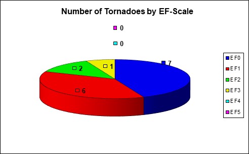
| Enhanced Fujita Tornado Scale: | ||||||||
| EF0 - Gale Tornado (65-85 mph) | ||||||||
| EF1 - Moderate Tornado (86-110 mph) | ||||||||
| EF2 - Significant Tornado (111-135 mph) | ||||||||
| EF3 - Severe Tornado (136-165 mph) | ||||||||
| EF4 - Devastating Tornado (166-200 mph) | ||||||||
| EF5 - Incredible Tornado (Over 200 mph) | ||||||||
| Statistics last updated: July 25,2022 |

