258 AM EDT Tue Jul 14 2026
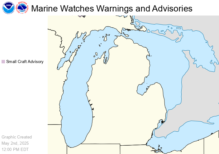
.MARINE...
A hot airmass (850 mb temps in the mid-twenties) will be in place
today over the Central Great Lakes, leading to stable low level
profiles. This should hold the max westerly winds in the 20 to 25
knot range, with the highest winds across northern third of Lake
Huron due to the channeling through the straits. A mainly dry
backdoor cold front dropping south Tuesday night into Wednesday will
allow winds to veer to the northwest behind the front, but still
only topping out around 20 knots Wednesday evening over the north
half of Lake Huron. Northwest winds at or below 20 knots holds on
Thursday. The forecast on Friday and Saturday unravels due to
conflicting model guidance regarding the location and magnitude of a
surface low moving through the Great Lakes region. This has
significant impact not only on wind speeds, but also on wind
direction, along with bringing chances of showers and thunderstorms.
Current Regional Radar
|
Current Hazards
Latest Weather Story
|
(click to enlarge)
 |
 |
 |
(click to enlarge)
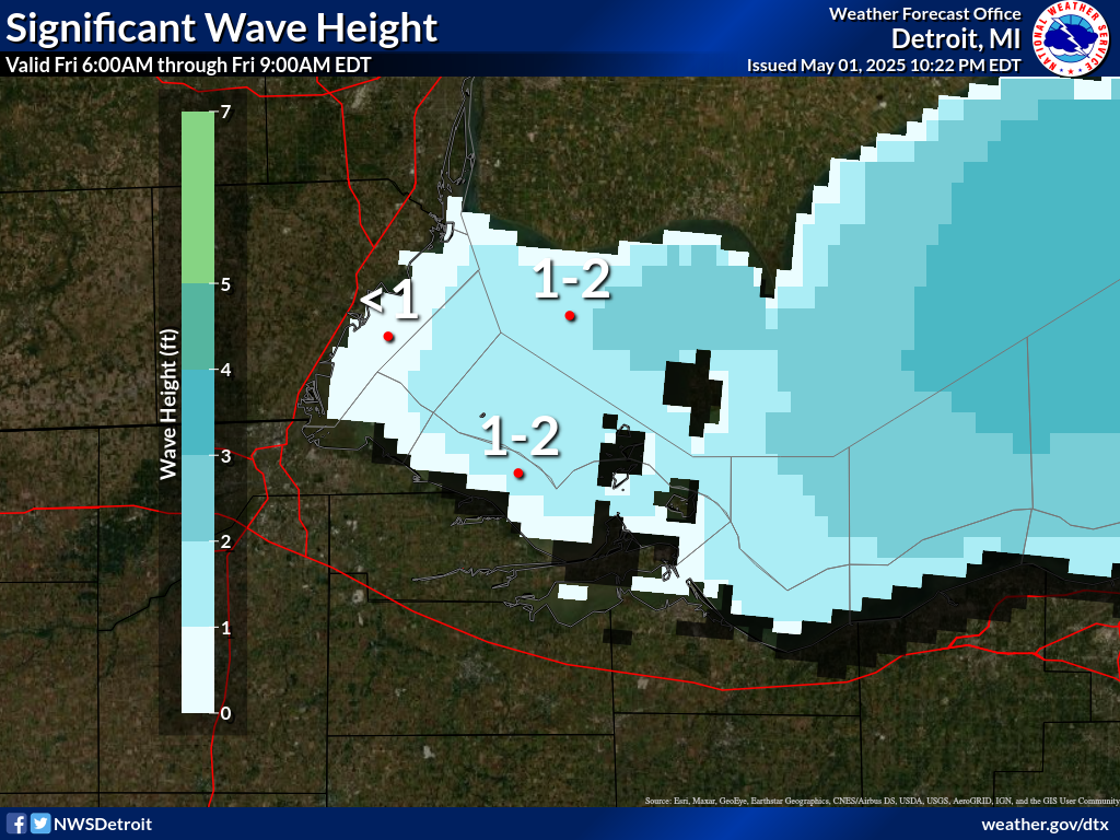
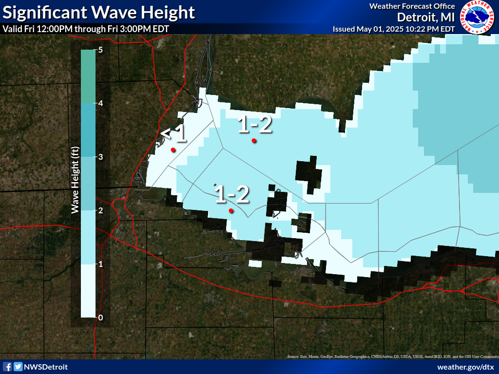
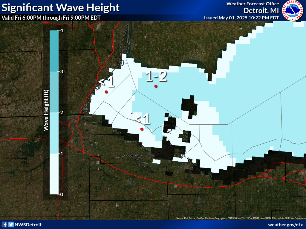
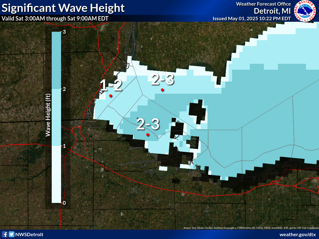
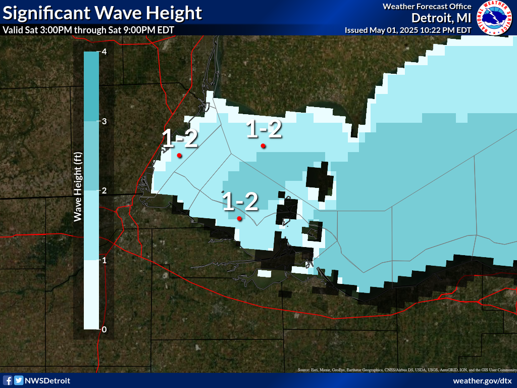
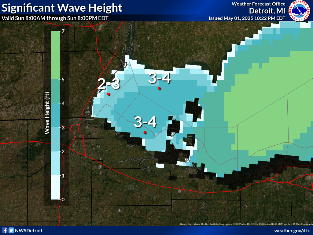
| through tomorrow | ||||||
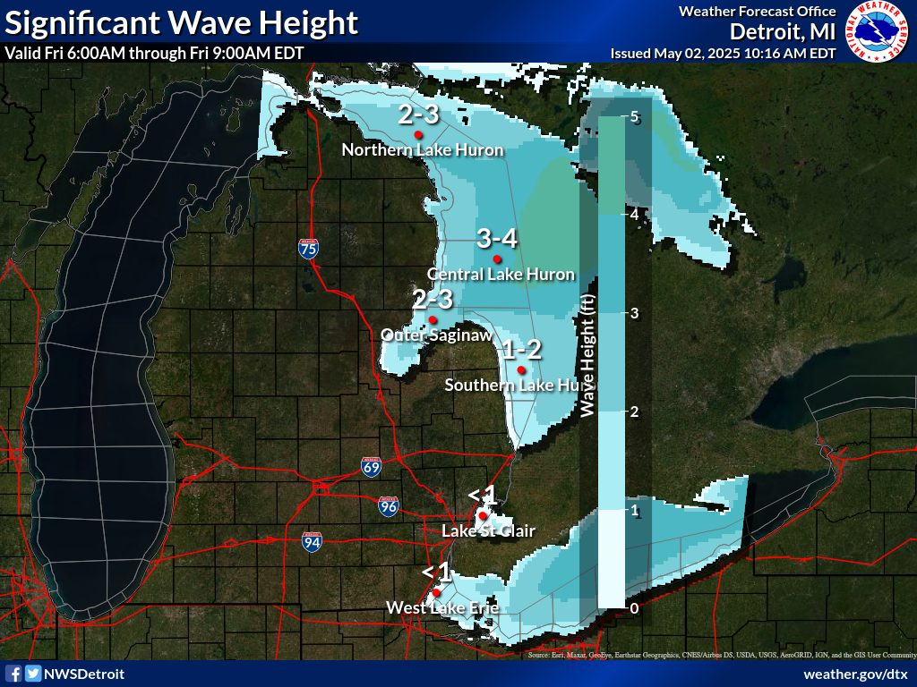
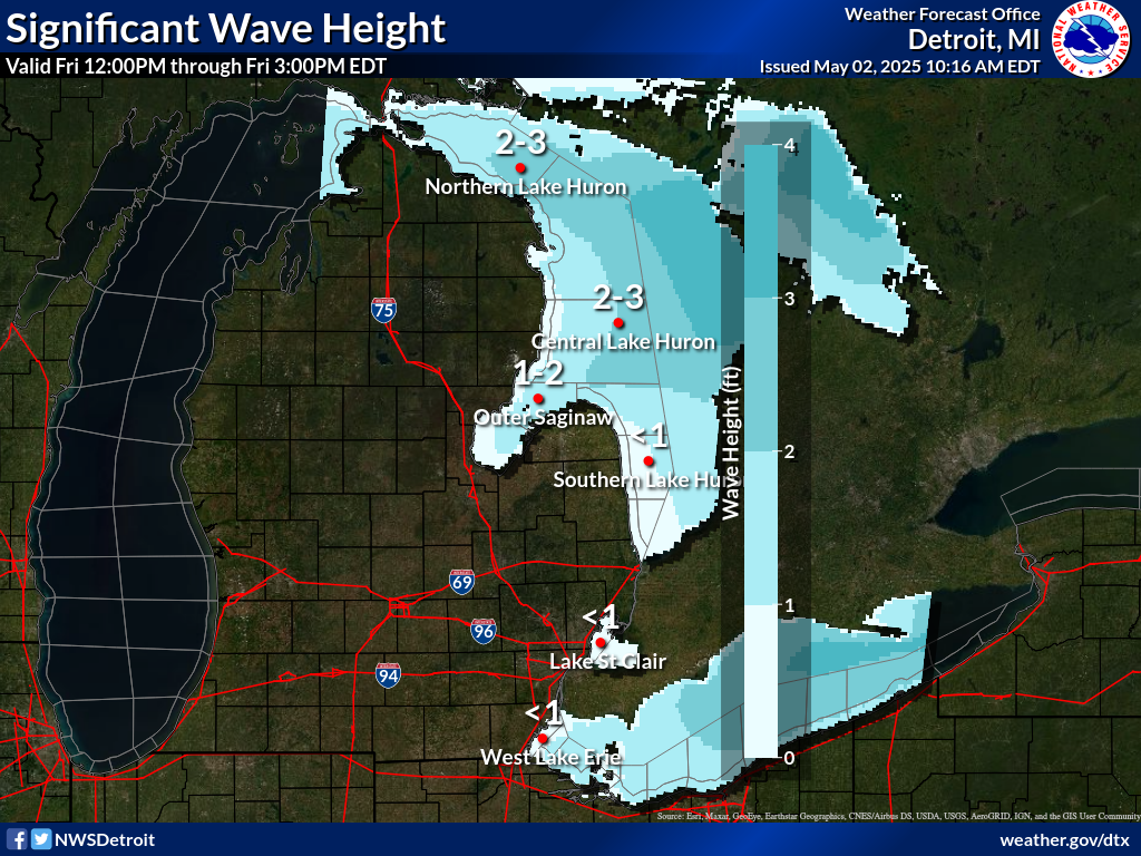
Significant |
 |
 |
 |
 |
 |
 |
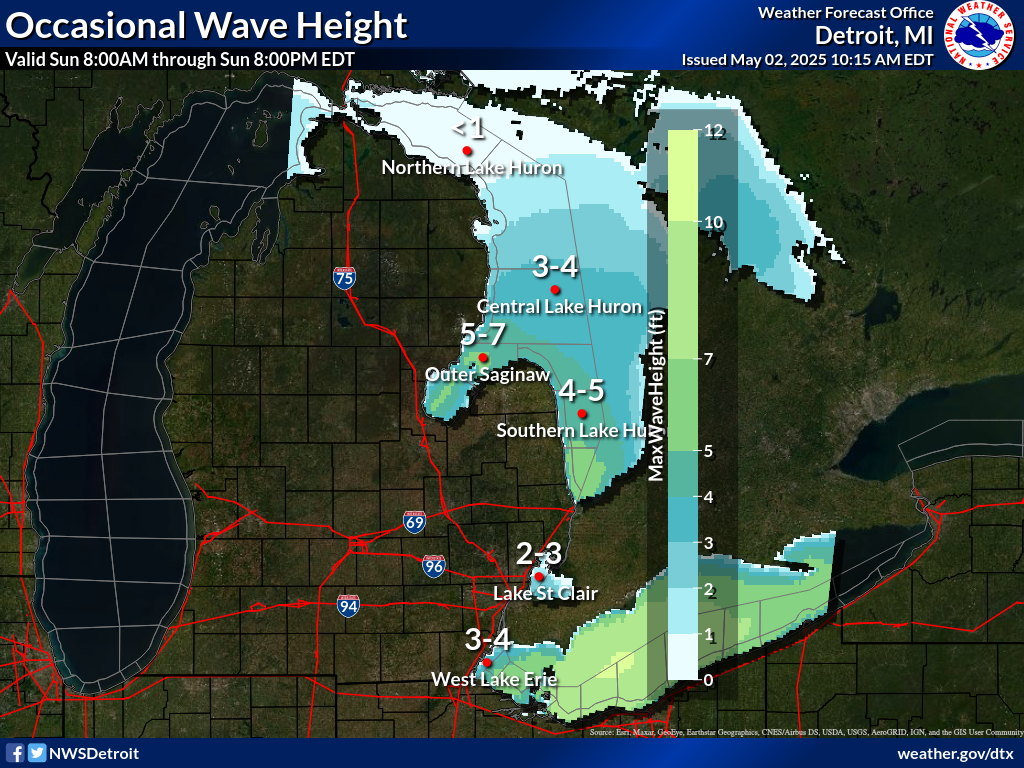
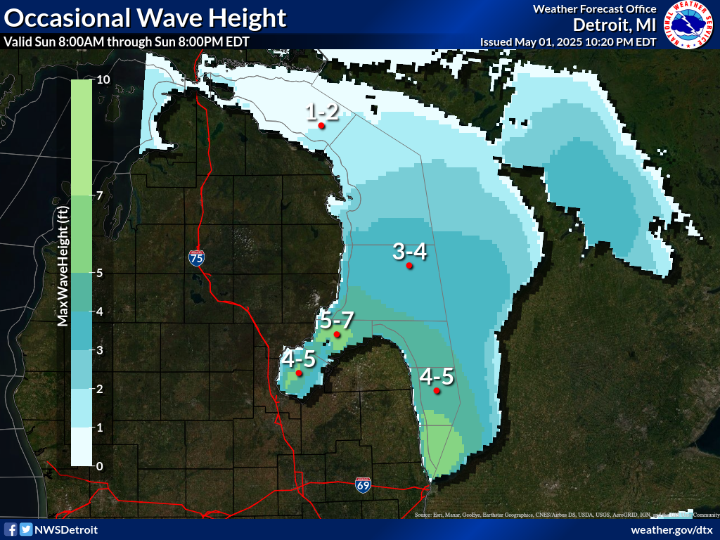
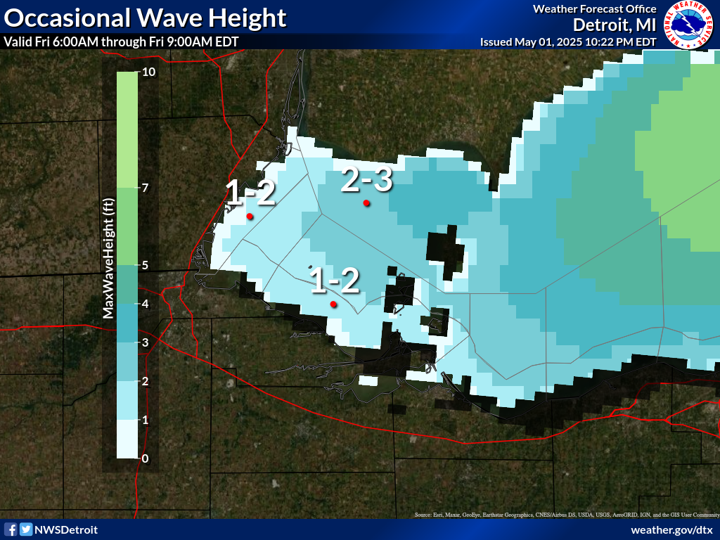
Occasional(top 10%) |
 |
 |
 |
 |
 |
|
679
FZUS63 KDTX 141328
GLFLH
Open Lake Forecast for Lake Huron
National Weather Service Detroit/Pontiac MI
928 AM EDT Tue Jul 14 2026
For waters beyond five nautical miles off shore on Lake Huron
Waves are the significant wave height - the average of the highest
1/3 of the wave spectrum. Occasional wave height is the average of
the highest 1/10 of the wave spectrum.
.SYNOPSIS...High pressure, 30.20 inches, will hold over Iowa
today. A mainly dry cold front will drop south through the
Central Great Lakes tonight and Wednesday. Weak high pressure
follows for Thursday.
LHZ361-142130-
Lake Huron from 5NM east of Mackinac Bridge to Presque Isle Lt
beyond 5 NM off shore-
928 AM EDT Tue Jul 14 2026
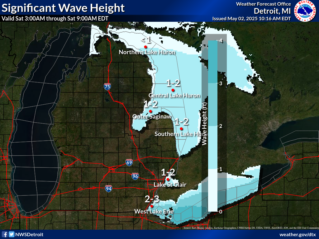
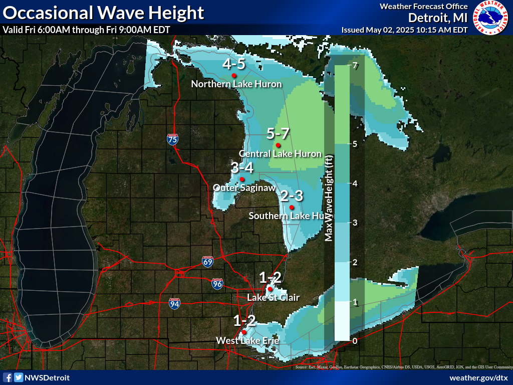
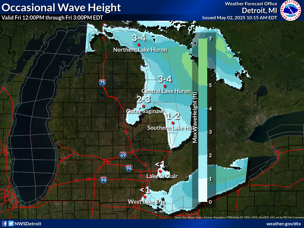
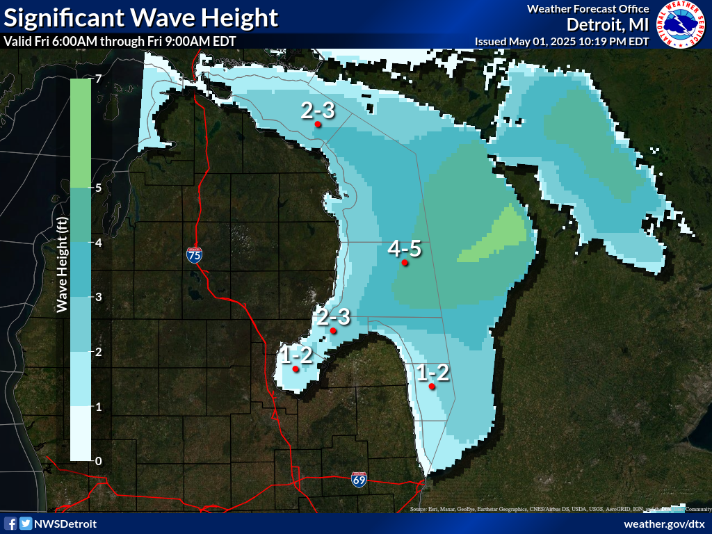
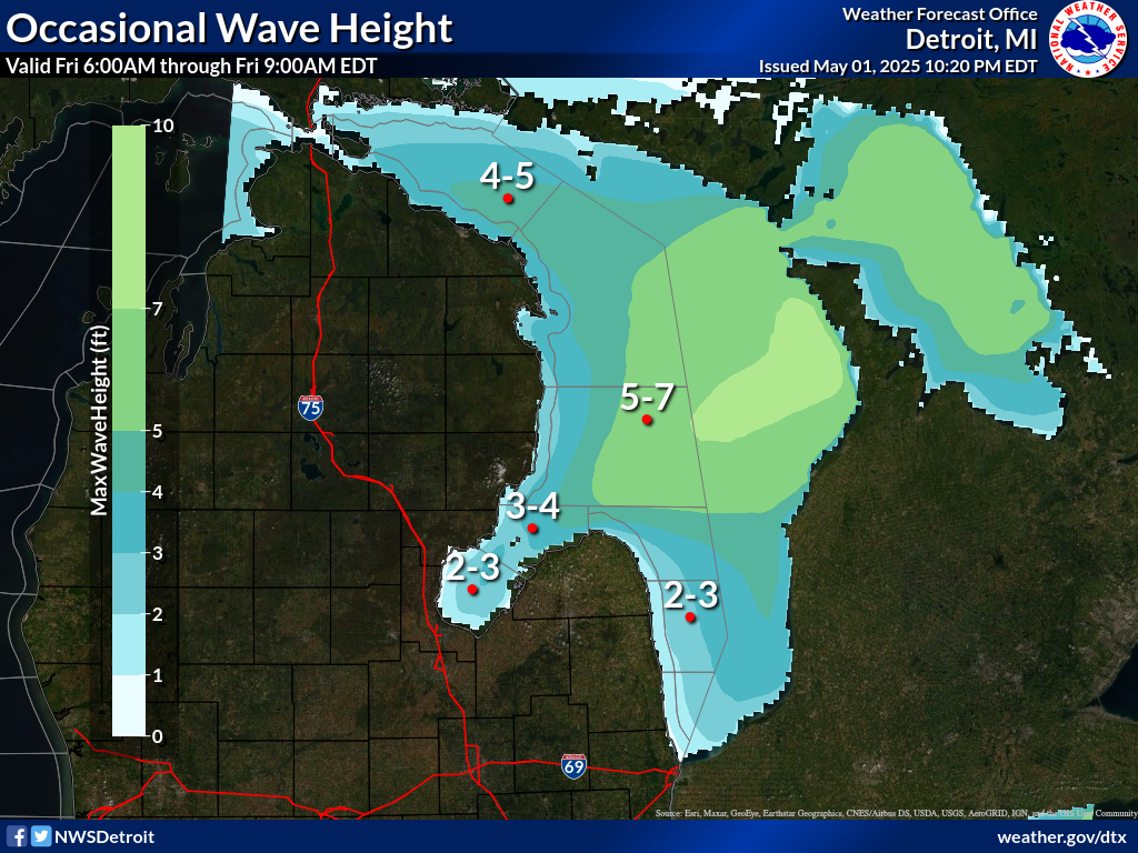
.REST OF TODAY...West winds 15 to 20 knots decreasing to 10 to
15 knots in the afternoon. Waves 2 to 4 feet.
.TONIGHT...West winds 10 to 15 knots becoming northwest 5 to
10 knots after midnight. Waves 2 to 4 feet subsiding to 1 to
3 feet after midnight.
.WEDNESDAY...Northwest winds 5 to 10 knots. Waves 2 feet or less.
.WEDNESDAY NIGHT...Northwest winds 10 to 15 knots. Waves 2 to
4 feet subsiding to 1 to 3 feet after midnight.
.THURSDAY...Northwest winds 10 to 15 knots becoming north 5 to
10 knots late in the evening. Waves 1 to 3 feet.
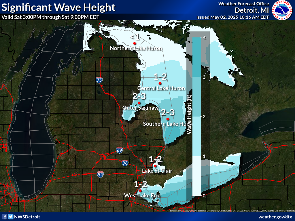
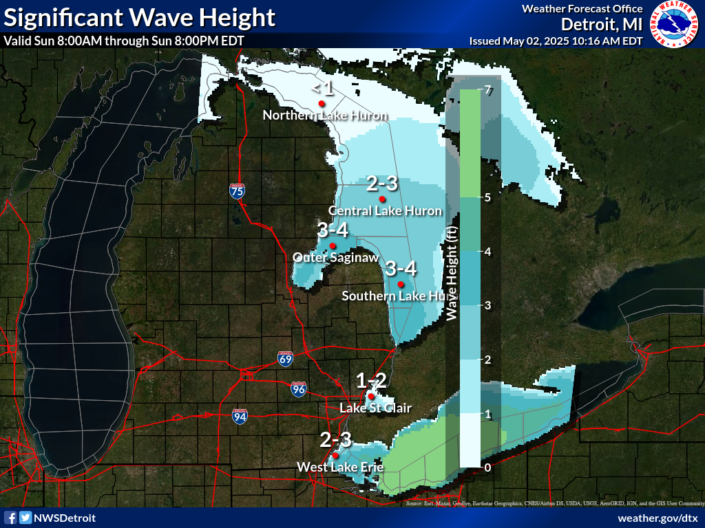
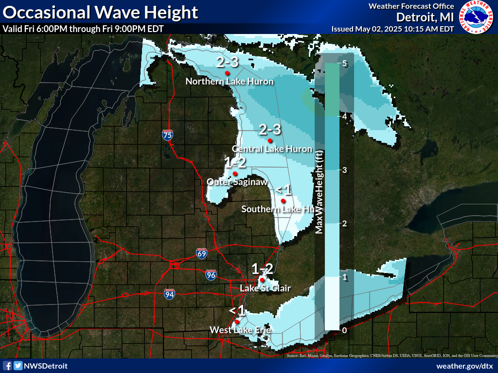
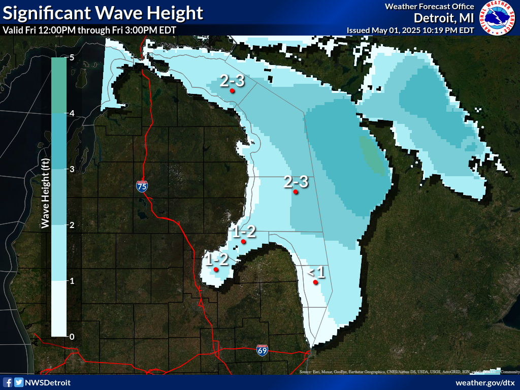
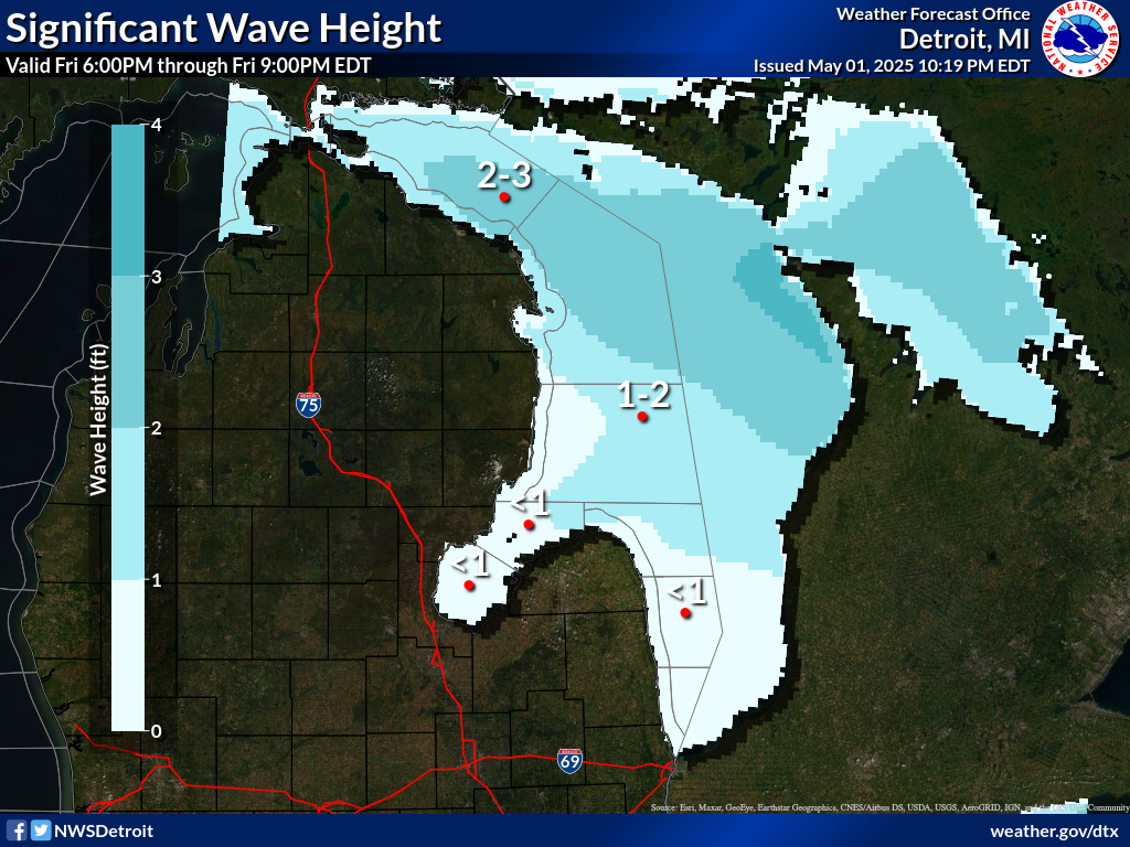
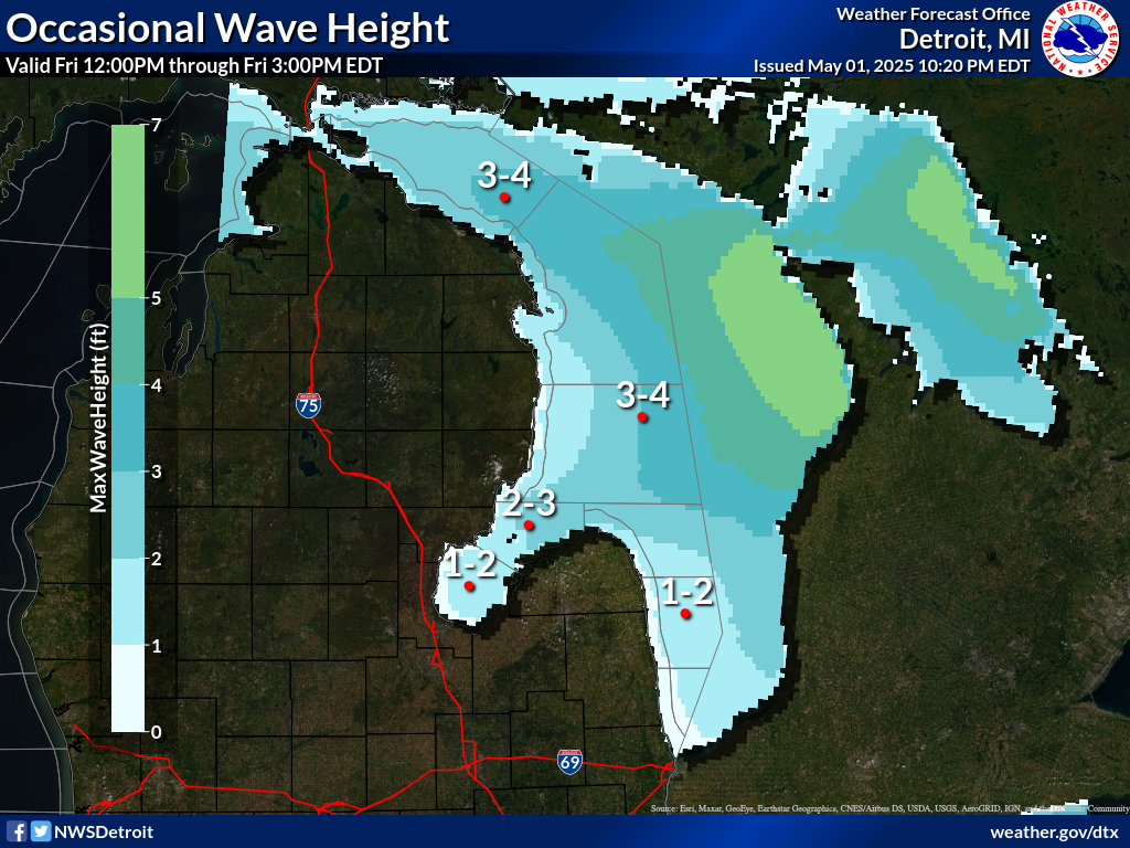
.FRIDAY...East winds 5 to 10 knots veering to the southeast by
midnight. A chance of showers by midnight. Waves 1 to 3 feet.
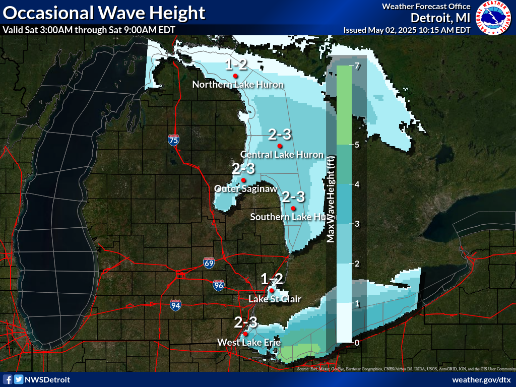
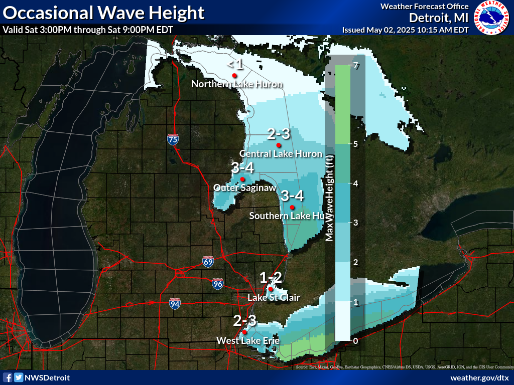
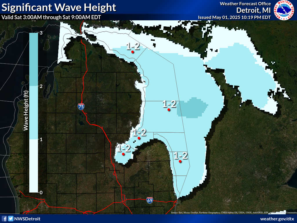
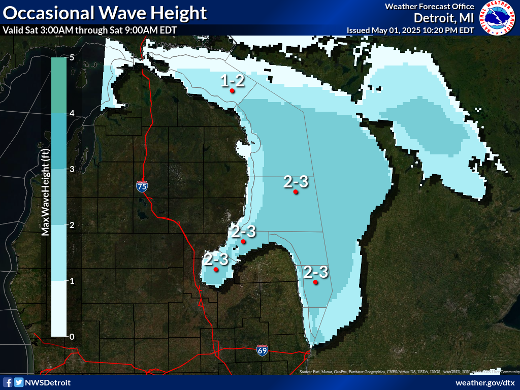
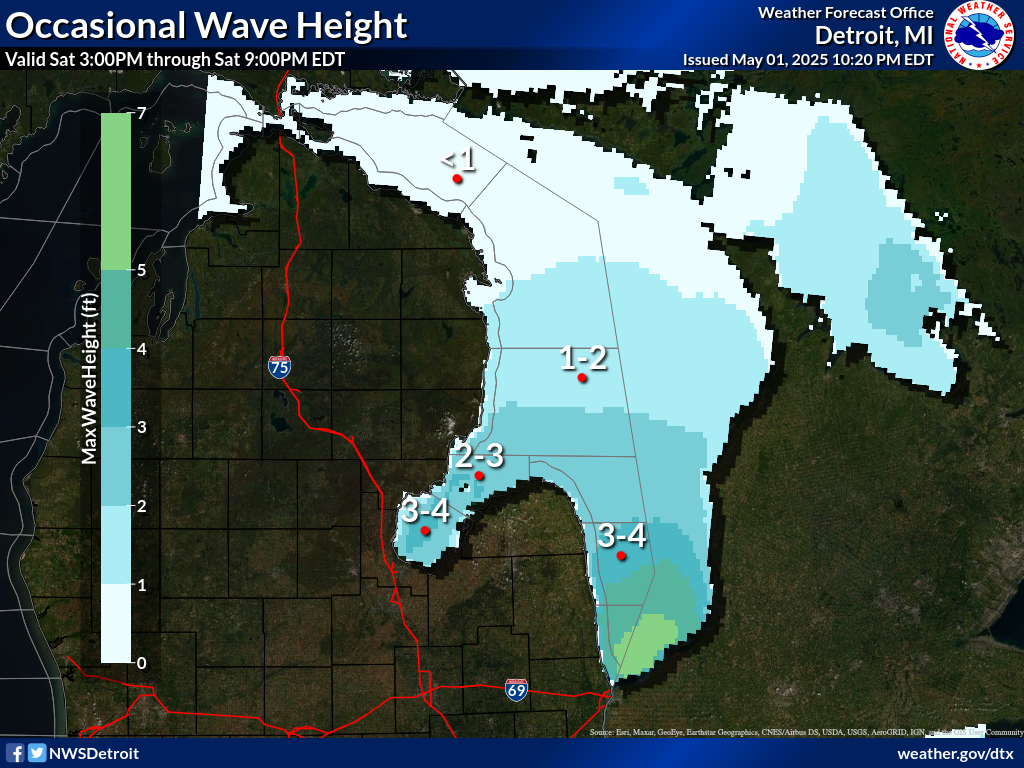
.SATURDAY...South winds 5 to 10 knots increasing to 10 to
15 knots in the late morning and early afternoon...then becoming
east 5 to 10 knots . A chance of showers. Waves 1 to 3 feet.
$$
LHZ362-363-142130-
Lake Huron from Presque Isle Light to Sturgeon Point MI beyond
5NM off shore-
Lake Huron from Sturgeon Point to Alabaster MI beyond 5NM off
shore-
928 AM EDT Tue Jul 14 2026
.REST OF TODAY...Southwest winds 10 to 15 knots decreasing to
5 to 10 knots in the afternoon. Waves 2 to 4 feet.
.TONIGHT...Southwest winds 5 to 10 knots veering to the west in
the late evening and overnight. Waves 2 to 4 feet.
.WEDNESDAY...Northwest winds 5 to 10 knots. Waves 1 to 3 feet.
.WEDNESDAY NIGHT...Northwest winds 10 to 15 knots. Waves 2 to
4 feet.
.THURSDAY...Northwest winds 5 to 10 knots increasing to 10 to
15 knots late in the afternoon...then decreasing to 5 to 10 knots
late in the evening. Waves 1 to 3 feet.
.FRIDAY...Northeast winds 5 to 10 knots veering to the east by
midnight. A chance of showers by midnight. Waves 2 feet or less.
.SATURDAY...Southeast winds 5 to 10 knots becoming north 10 to
15 knots by midnight. A chance of showers. Waves 1 to 3 feet.
$$
LHZ462>464-142130-
Lake Huron from Port Austin to Harbor Beach beyond 5NM Off Shore-
Lake Huron from Harbor Beach to Port Sanilac beyond 5NM Off Shore-
Lake Huron from Port Sanilac to Port Huron beyond 5NM Off Shore-
928 AM EDT Tue Jul 14 2026
.REST OF TODAY...West winds 10 to 15 knots becoming southwest
5 to 10 knots in the afternoon. Waves 1 to 3 feet.
.TONIGHT...Southwest winds 10 to 15 knots veering to the west
late in the evening...then becoming northwest 5 to 10 knots after
midnight. Waves 1 to 3 feet.
.WEDNESDAY...North winds 5 to 10 knots. Waves 2 feet or less.
.WEDNESDAY NIGHT...Light and variable winds becoming northwest
5 to 10 knots after midnight. Waves 2 feet or less.
.THURSDAY...Northwest winds 5 to 10 knots becoming light and
variable...then becoming north 5 to 10 knots late in the evening.
Waves 2 feet or less.
.FRIDAY...North winds 5 to 10 knots veering to the northeast by
midnight. A chance of showers by midnight. Waves 2 feet or less.
.SATURDAY...Southeast winds 5 to 10 knots. A chance of showers. A
chance of thunderstorms early in the evening. Waves 1 to 3 feet
building to 2 to 4 feet by midnight.
$$
LHZ461-142130-
MAFOR 1415/
HURON NORTH 12610 14710 12700. Waves 2 to 4 feet this afternoon
and tonight. Waves 2 feet or less Wednesday morning.
HURON SOUTH 11600 12510 11600 13700 11800. Waves 1 to 3 feet.
$$
SF
Experimental modernized open lake forecast is available online at
weather.gov/dtx/glftable (all lower case)
Graphical marine forecasts are available online at
weather.gov/greatlakes (all lower case)
277
FZUS63 KDTX 141328
GLFSC
Lake St Clair Forecast
National Weather Service Detroit/Pontiac MI
928 AM EDT Tue Jul 14 2026
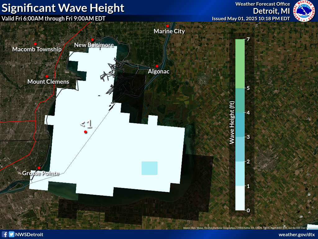
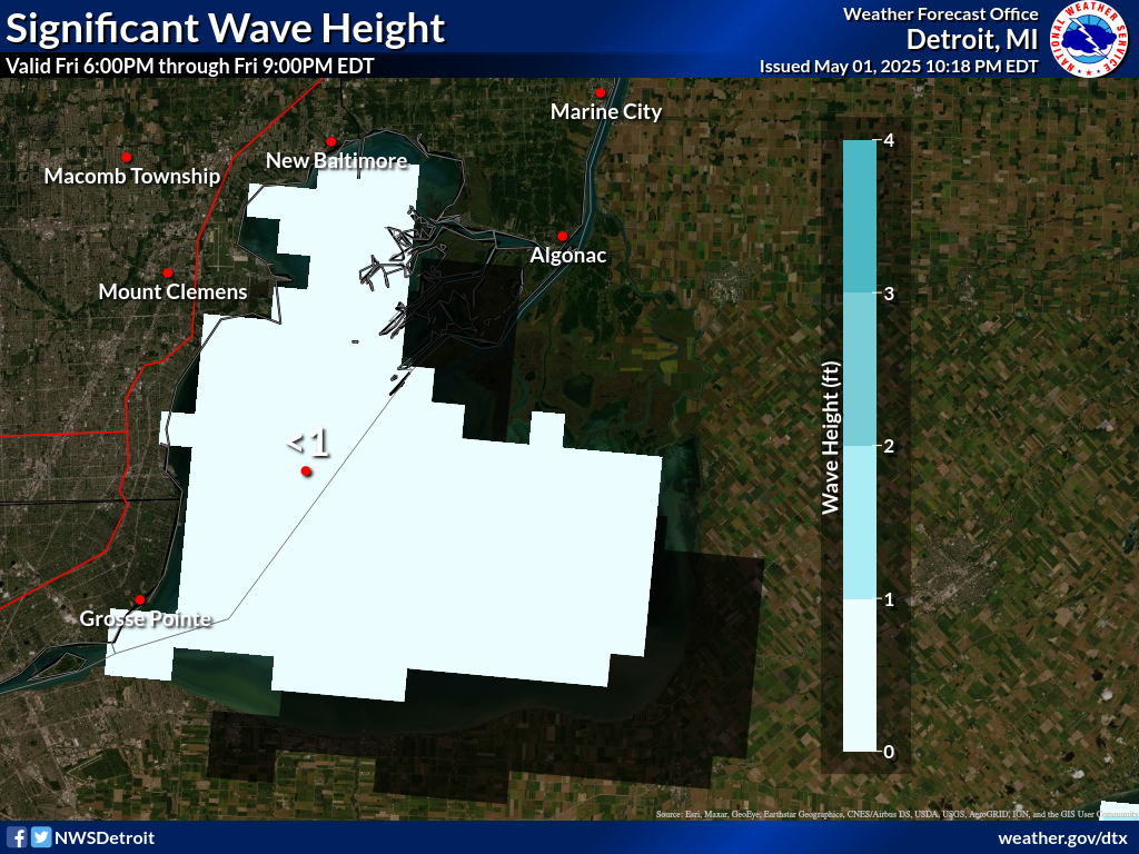
Waves are the significant wave height - the average of the highest
1/3 of the wave spectrum. Occasional wave height is the average of
the highest 1/10 of the wave spectrum.
.SYNOPSIS...High pressure, 30.20 inches, will hold over Iowa
today. A mainly dry cold front will drop south through the
Central Great Lakes tonight and Wednesday. Weak high pressure
follows for Thursday.
LCZ460-142130-
Lake St Clair-
928 AM EDT Tue Jul 14 2026
.REST OF TODAY...Southwest winds 5 to 15 knots. Mostly sunny.
Waves 2 feet or less.
.TONIGHT...Southwest winds 5 to 10 knots becoming west 10 to 15
knots in the late evening and overnight. Mostly clear. Waves 2 feet
or less.
.WEDNESDAY...Northwest winds 5 to 10 knots early in the morning
becoming light and variable...then becoming northeast 5 to 10 knots
early in the afternoon. Mostly sunny. Waves 2 feet or less.
.WEDNESDAY NIGHT...Northeast winds 10 to 15 knots diminishing to 5
to 10 knots in the late evening and overnight. Mostly clear. Waves 2
feet or less.
.THURSDAY...North winds 5 to 10 knots. Mostly clear. Waves 2 feet or
less.
.FRIDAY...East winds 5 to 10 knots. Mostly clear. Waves 2 feet or
less.
.SATURDAY...West winds 10 to 15 knots. Partly cloudy. Showers likely
and a chance of thunderstorms. Waves 2 feet or less.
$$
SF
Experimental modernized open lake forecast is available online at
weather.gov/dtx/glftablesc
Graphical marine forecasts are available at weather.gov/greatlakes
111
FZUS53 KDTX 141329
NSHDTX
Nearshore Marine Forecast for Michigan
National Weather Service Detroit/Pontiac MI
929 AM EDT Tue Jul 14 2026
For waters within five nautical miles of shore
Waves are the significant wave height - the average of the highest
1/3 of the wave spectrum. Occasional wave height is the average of
the highest 1/10 of the wave spectrum.
LHZ422-142130-
Inner Saginaw Bay SW of Point Au Gres to Bay Port MI-
929 AM EDT Tue Jul 14 2026
.REST OF TODAY...Southwest winds 10 to 15 knots. Mostly sunny.
Waves 1 to 3 feet.
.TONIGHT...West winds 15 to 20 knots diminishing to 10 to
15 knots in the late evening and overnight. Mostly clear. Waves
1 to 3 feet.
.WEDNESDAY...North winds 5 to 10 knots becoming northeast 10 to
15 knots early in the afternoon. Mostly sunny. Waves 2 feet or
less.
.WEDNESDAY NIGHT...Northeast winds 10 to 15 knots diminishing to
5 to 10 knots in the late evening and early morning, then backing
to the northwest after midnight. Mostly clear. Waves 2 feet or
less.
See Lake Huron Open Lake Forecast for days 3 through 5.
$$
LHZ421-142130-
Outer Saginaw Bay SW of Alabaster to Port Austin MI to Inner
Saginaw Bay-
929 AM EDT Tue Jul 14 2026
.REST OF TODAY...Southwest winds 10 to 15 knots increasing to
15 to 20 knots late in the afternoon. Sunny. Waves 1 to 3 feet.
.TONIGHT...West winds 10 to 15 knots. Mostly clear. Waves 1 to
3 feet.
.WEDNESDAY...North winds 5 to 10 knots becoming east 10 to
15 knots early in the afternoon. Mostly sunny. Waves 2 feet or
less.
.WEDNESDAY NIGHT...Northeast winds 10 to 15 knots becoming north
5 to 10 knots in the late evening and overnight. Mostly clear.
Waves 2 feet or less.
See Lake Huron Open Lake Forecast for days 3 through 5.
$$
LHZ441-142130-
Port Austin to Harbor Beach MI-
929 AM EDT Tue Jul 14 2026
.REST OF TODAY...West winds 10 to 15 knots increasing to 15 to
20 knots late in the afternoon. Mostly sunny. Waves 1 to 3 feet.
.TONIGHT...West winds 10 to 15 knots. Mostly clear. Waves 1 to
3 feet.
.WEDNESDAY...North winds 5 to 10 knots veering to the northeast
early in the afternoon. Mostly sunny. Waves 2 feet or less.
.WEDNESDAY NIGHT...Light and variable winds becoming northwest
5 to 10 knots in the late evening and overnight. Partly cloudy.
Waves 2 feet or less.
See Lake Huron Open Lake Forecast for days 3 through 5.
$$
LHZ442-142130-
Harbor Beach to Port Sanilac MI-
929 AM EDT Tue Jul 14 2026
.REST OF TODAY...West winds 10 to 15 knots. Mostly sunny. Waves
2 feet or less.
.TONIGHT...West winds 10 to 15 knots. Mostly clear. Waves 2 feet
or less.
.WEDNESDAY...North winds 5 to 10 knots. Mostly sunny. Waves
2 feet or less.
.WEDNESDAY NIGHT...Northeast winds 5 to 10 knots early in the
evening becoming light and variable, then becoming northwest 5 to
10 knots after midnight. Partly cloudy. Waves 2 feet or less.
See Lake Huron Open Lake Forecast for days 3 through 5.
$$
LHZ443-142130-
Port Sanilac to Port Huron MI-
929 AM EDT Tue Jul 14 2026
.REST OF TODAY...West winds 10 to 15 knots. Mostly sunny. Waves
2 feet or less.
.TONIGHT...West winds 10 to 15 knots. Mostly clear. Waves 2 feet
or less.
.WEDNESDAY...Northwest winds 10 to 15 knots becoming north 5 to
10 knots in the late morning and afternoon. Mostly sunny. Waves
2 feet or less.
.WEDNESDAY NIGHT...Northeast winds 5 to 10 knots backing to the
north after midnight. Mostly clear. Waves 2 feet or less.
See Lake Huron Open Lake Forecast for days 3 through 5.
$$
LEZ444-142130-
Michigan Waters of Lake Erie from Detroit River to North Cape MI-
929 AM EDT Tue Jul 14 2026
.REST OF TODAY...Southwest winds 5 to 10 knots. Sunny. Waves
2 feet or less.
.TONIGHT...Southwest winds 5 to 10 knots becoming west 10 to
15 knots in the late evening and early morning, then diminishing
to 5 to 10 knots after midnight. Mostly clear. Waves 2 feet or
less.
.WEDNESDAY...West winds 5 to 10 knots. Mostly sunny. Waves 2 feet
or less.
.WEDNESDAY NIGHT...West winds 5 to 10 knots veering to the north
in the late evening and overnight. Mostly clear. Waves 2 feet or
less.
See Lake Erie Open Lake Forecast for days 3 through 5.
The water temperature at Belle Isle is 74 degrees.
$$
SF
You can obtain your latest National Weather Service forecasts online
a www.weather.gov/greatlakes
584
FZUS61 KCLE 141353
GLFLE
Open Lake Forecast for Lake Erie
National Weather Service Cleveland OH
953 AM EDT Tue Jul 14 2026
For waters beyond five nautical miles of shore on Lake Erie
Waves are the significant wave height - the average of the highest
1/3 of the wave spectrum. Occasional wave height is the average of
the highest 1/10 of the wave spectrum.
.SYNOPSIS...
High pressure 30.20 inches continues to build across the Great
Lakes region and into the Ohio Valley through Wednesday. A cold
front will move south across Lake Erie on Wednesday night with a
secondary cold front pushing south on Saturday.
LEZ162-163-142015-
Detroit River Lt. to Maumee Bay OH to Reno Beach OH beyond 5NM
offshoreline to US-Canadian border-
Reno Beach to The Islands OH beyond 5NM off shoreline to US-
Canadian border-
953 AM EDT Tue Jul 14 2026
.THIS AFTERNOON...West winds 5 to 10 knots becoming southwest.
Waves 1 foot or less.
.TONIGHT...Southwest winds around 10 knots becoming west. Waves
2 feet or less.
.WEDNESDAY...West winds 5 to 10 knots becoming southwest. Waves
2 feet or less.
.WEDNESDAY NIGHT...Southwest winds 5 to 10 knots becoming
northeast. Waves 1 foot or less.
.THURSDAY...Northeast winds 10 knots or less becoming east. Waves
1 foot or less.
.FRIDAY...East winds 5 to 10 knots becoming southeast. A chance
of showers and thunderstorms. Waves 2 feet or less.
.SATURDAY...South winds 10 to 15 knots becoming west. A chance of
showers and thunderstorms during the day, then showers likely
with a chance of thunderstorms Saturday night. Waves 1 to 3 feet.
Winds and waves higher in and near thunderstorms.
$$
LEZ164>166-142015-
The Islands to Vermilion OH beyond 5 nm off shoreline to US-
Canadian border-
Vermilion to Avon Point OH beyond 5 nm off shoreline to US-
Canadian border-
Avon Point to Willowick OH beyond 5 nm off shoreline to US-
Canadian border-
953 AM EDT Tue Jul 14 2026
.THIS AFTERNOON...West winds 10 to 15 knots becoming southwest.
Waves 1 to 3 feet.
.TONIGHT...Southwest winds 10 to 15 knots becoming west. Waves
1 to 3 feet.
.WEDNESDAY...West winds 5 to 15 knots. Waves 1 to 3 feet.
.WEDNESDAY NIGHT...West winds 5 to 10 knots becoming northeast.
Waves 1 foot or less.
.THURSDAY...Northeast winds 10 knots or less becoming east. Waves
1 foot or less.
.FRIDAY...East winds 5 to 10 knots becoming southeast. A chance
of showers and thunderstorms Friday night. Waves 1 foot or less
building to 1 to 3 feet.
.SATURDAY...South winds 10 to 15 knots becoming west 15 to
20 knots. A chance of showers and thunderstorms during the day,
then showers likely with a chance of thunderstorms Saturday
night. Waves 2 to 4 feet subsiding to 1 to 3 feet.
Winds and waves higher in and near thunderstorms.
$$
LEZ061-167>169-142015-
Ripley to Buffalo NY extending from 5NM off shoreline to US-
Canadian border-Willowick to Geneva-on-the-
Lake OH beyond 5NM off shoreline to US-Canadian border-Geneva-on-
the-Lake to Conneaut OH beyond 5 nm off shoreline to US-
Canadian border-
Conneaut OH to Ripley NY beyond 5 nm off shoreline to US-
Canadian border-
953 AM EDT Tue Jul 14 2026
.THIS AFTERNOON...Southwest winds 15 to 20 knots. Waves 2 to
4 feet building to 3 to 6 feet.
.TONIGHT...Southwest winds 15 to 20 knots becoming west 10 to
15 knots. Waves 3 to 6 feet.
.WEDNESDAY...West winds 5 to 15 knots. Waves 2 to 4 feet
subsiding to 1 to 3 feet.
.WEDNESDAY NIGHT...West winds 5 to 10 knots becoming north. Waves
2 feet or less.
.THURSDAY...Northwest winds 5 to 10 knots becoming north. Waves
1 foot or less.
.FRIDAY...Northeast winds 5 to 10 knots becoming southeast. A
chance of showers Friday night. Waves 1 foot or less building to
1 to 3 feet.
.SATURDAY...South winds 5 to 15 knots becoming northwest 15 to
20 knots. A chance of showers and thunderstorms during the day,
then showers likely with a chance of thunderstorms Saturday
night. Waves 2 to 4 feet subsiding to 1 to 3 feet.
Winds and waves higher in and near thunderstorms.
$$
LEZ161-142015-
MAFOR 1415/
ERIE WEST 1/3 14510 13610 11600. Waves 2 feet or less this
afternoon. Waves 1 to 3 feet tonight. Waves 2 feet or less
Wednesday morning.
ERIE CENTRAL 1/3 11510 12520 11510 13610 11600. Waves 1 to 3 feet
building to 2 to 4 feet this afternoon. Waves 2 to 4 feet
tonight. Waves 1 to 3 feet Wednesday morning.
ERIE EAST 1/3 14520 11510 11610 12600. Waves 2 to 4 feet building
to 3 to 6 feet this afternoon. Waves 3 to 6 feet tonight. Waves 2
to 4 feet Wednesday morning.
$$
104
FZUS51 KCLE 141353
NSHCLE
Nearshore Marine Forecast
National Weather Service Cleveland OH
953 AM EDT Tue Jul 14 2026
For waters within five nautical miles of shore
Waves are the significant wave height - the average of the highest
1/3 of the wave spectrum. Occasional wave height is the average of
the highest 1/10 of the wave spectrum.
LEZ142-143-142015-
Maumee Bay to Reno Beach OH-Reno Beach to The Islands OH-
953 AM EDT Tue Jul 14 2026
.THIS AFTERNOON...West winds 5 to 10 knots becoming southwest.
Sunny. Waves 1 foot or less.
.TONIGHT...Southwest winds 5 to 10 knots becoming west. Mostly
clear. Waves 1 foot or less.
.WEDNESDAY...West winds 5 to 10 knots. Sunny. Waves 1 foot or
less.
.WEDNESDAY NIGHT...Southwest winds 5 to 10 knots becoming north.
Partly cloudy. Waves 1 foot or less.
See Lake Erie open lakes forecast for Thursday through Saturday.
The water temperature off Toledo is 79 degrees, off Cleveland 65
degrees, and off Erie 64 degrees.
$$
LEZ144>146-142015-
The Islands to Vermilion OH-Vermilion to Avon Point OH-
Avon Point to Willowick OH-
953 AM EDT Tue Jul 14 2026
.THIS AFTERNOON...West winds 5 to 10 knots. Sunny. Waves 2 feet or
less.
.TONIGHT...Southwest winds 5 to 15 knots becoming west. Mostly
clear. Waves 1 to 3 feet.
.WEDNESDAY...West winds 5 to 15 knots becoming northwest. Sunny.
Waves 1 to 3 feet.
.WEDNESDAY NIGHT...West winds 5 to 10 knots becoming north.
Partly cloudy. Waves 1 foot or less.
See Lake Erie open lakes forecast for Thursday through Saturday.
The water temperature off Toledo is 79 degrees, off Cleveland 65
degrees, and off Erie 64 degrees.
$$
LEZ147>149-142015-
Willowick to Geneva-on-the Lake OH-Geneva-on-the-
Lake to Conneaut OH-Conneaut OH to Ripley NY-
953 AM EDT Tue Jul 14 2026
.THIS AFTERNOON...Southwest winds 15 to 20 knots becoming west.
Sunny. Waves 1 to 3 feet building to 2 to 4 feet.
.TONIGHT...Southwest winds 15 to 20 knots becoming west 10 to
15 knots. Mostly clear. Waves 2 to 4 feet subsiding to 1 to
3 feet.
.WEDNESDAY...West winds 5 to 15 knots. Mostly sunny. Waves 1 to
3 feet.
.WEDNESDAY NIGHT...West winds 10 knots or less becoming north.
Partly cloudy. Waves 2 feet or less.
See Lake Erie open lakes forecast for Thursday through Saturday.
The water temperature off Toledo is 79 degrees, off Cleveland 65
degrees, and off Erie 64 degrees.
$$
Tawas |
Saginaw River |
Harbor Beach |
Port Huron |
(click to enlarge)
| through tomorrow | ||||||
Significant |
 |
 |
 |
 |
 |
 |
Occasional(top 10%) |
 |
 |
 |
 |
 |
 |
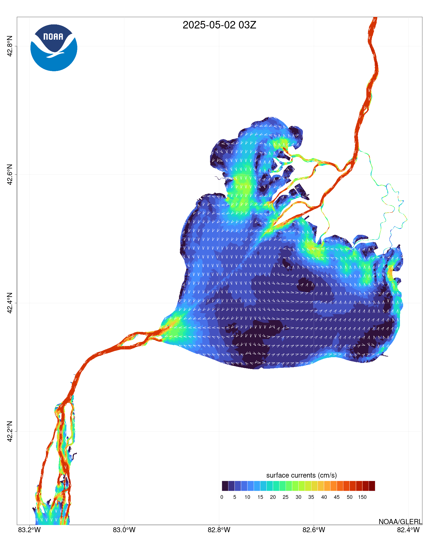
(click image to go to GLERL GLCFS)
679
FZUS63 KDTX 141328
GLFLH
Open Lake Forecast for Lake Huron
National Weather Service Detroit/Pontiac MI
928 AM EDT Tue Jul 14 2026
For waters beyond five nautical miles off shore on Lake Huron
Waves are the significant wave height - the average of the highest
1/3 of the wave spectrum. Occasional wave height is the average of
the highest 1/10 of the wave spectrum.
.SYNOPSIS...High pressure, 30.20 inches, will hold over Iowa
today. A mainly dry cold front will drop south through the
Central Great Lakes tonight and Wednesday. Weak high pressure
follows for Thursday.
LHZ361-142130-
Lake Huron from 5NM east of Mackinac Bridge to Presque Isle Lt
beyond 5 NM off shore-
928 AM EDT Tue Jul 14 2026
.REST OF TODAY...West winds 15 to 20 knots decreasing to 10 to
15 knots in the afternoon. Waves 2 to 4 feet.
.TONIGHT...West winds 10 to 15 knots becoming northwest 5 to
10 knots after midnight. Waves 2 to 4 feet subsiding to 1 to
3 feet after midnight.
.WEDNESDAY...Northwest winds 5 to 10 knots. Waves 2 feet or less.
.WEDNESDAY NIGHT...Northwest winds 10 to 15 knots. Waves 2 to
4 feet subsiding to 1 to 3 feet after midnight.
.THURSDAY...Northwest winds 10 to 15 knots becoming north 5 to
10 knots late in the evening. Waves 1 to 3 feet.
.FRIDAY...East winds 5 to 10 knots veering to the southeast by
midnight. A chance of showers by midnight. Waves 1 to 3 feet.
.SATURDAY...South winds 5 to 10 knots increasing to 10 to
15 knots in the late morning and early afternoon...then becoming
east 5 to 10 knots . A chance of showers. Waves 1 to 3 feet.
$$
LHZ362-363-142130-
Lake Huron from Presque Isle Light to Sturgeon Point MI beyond
5NM off shore-
Lake Huron from Sturgeon Point to Alabaster MI beyond 5NM off
shore-
928 AM EDT Tue Jul 14 2026
.REST OF TODAY...Southwest winds 10 to 15 knots decreasing to
5 to 10 knots in the afternoon. Waves 2 to 4 feet.
.TONIGHT...Southwest winds 5 to 10 knots veering to the west in
the late evening and overnight. Waves 2 to 4 feet.
.WEDNESDAY...Northwest winds 5 to 10 knots. Waves 1 to 3 feet.
.WEDNESDAY NIGHT...Northwest winds 10 to 15 knots. Waves 2 to
4 feet.
.THURSDAY...Northwest winds 5 to 10 knots increasing to 10 to
15 knots late in the afternoon...then decreasing to 5 to 10 knots
late in the evening. Waves 1 to 3 feet.
.FRIDAY...Northeast winds 5 to 10 knots veering to the east by
midnight. A chance of showers by midnight. Waves 2 feet or less.
.SATURDAY...Southeast winds 5 to 10 knots becoming north 10 to
15 knots by midnight. A chance of showers. Waves 1 to 3 feet.
$$
LHZ462>464-142130-
Lake Huron from Port Austin to Harbor Beach beyond 5NM Off Shore-
Lake Huron from Harbor Beach to Port Sanilac beyond 5NM Off Shore-
Lake Huron from Port Sanilac to Port Huron beyond 5NM Off Shore-
928 AM EDT Tue Jul 14 2026
.REST OF TODAY...West winds 10 to 15 knots becoming southwest
5 to 10 knots in the afternoon. Waves 1 to 3 feet.
.TONIGHT...Southwest winds 10 to 15 knots veering to the west
late in the evening...then becoming northwest 5 to 10 knots after
midnight. Waves 1 to 3 feet.
.WEDNESDAY...North winds 5 to 10 knots. Waves 2 feet or less.
.WEDNESDAY NIGHT...Light and variable winds becoming northwest
5 to 10 knots after midnight. Waves 2 feet or less.
.THURSDAY...Northwest winds 5 to 10 knots becoming light and
variable...then becoming north 5 to 10 knots late in the evening.
Waves 2 feet or less.
.FRIDAY...North winds 5 to 10 knots veering to the northeast by
midnight. A chance of showers by midnight. Waves 2 feet or less.
.SATURDAY...Southeast winds 5 to 10 knots. A chance of showers. A
chance of thunderstorms early in the evening. Waves 1 to 3 feet
building to 2 to 4 feet by midnight.
$$
LHZ461-142130-
MAFOR 1415/
HURON NORTH 12610 14710 12700. Waves 2 to 4 feet this afternoon
and tonight. Waves 2 feet or less Wednesday morning.
HURON SOUTH 11600 12510 11600 13700 11800. Waves 1 to 3 feet.
$$
SF
Experimental modernized open lake forecast is available online at
weather.gov/dtx/glftable (all lower case)
Graphical marine forecasts are available online at
weather.gov/greatlakes (all lower case)
St Clair Shores |
Belle Isle |
(click to enlarge)
| through tomorrow | ||||||
Significant |
 |
 |
 |
 |
 |
 |
Occasional(top 10%) |
 |
 |
 |
 |
 |
 |
277
FZUS63 KDTX 141328
GLFSC
Lake St Clair Forecast
National Weather Service Detroit/Pontiac MI
928 AM EDT Tue Jul 14 2026
Waves are the significant wave height - the average of the highest
1/3 of the wave spectrum. Occasional wave height is the average of
the highest 1/10 of the wave spectrum.
.SYNOPSIS...High pressure, 30.20 inches, will hold over Iowa
today. A mainly dry cold front will drop south through the
Central Great Lakes tonight and Wednesday. Weak high pressure
follows for Thursday.
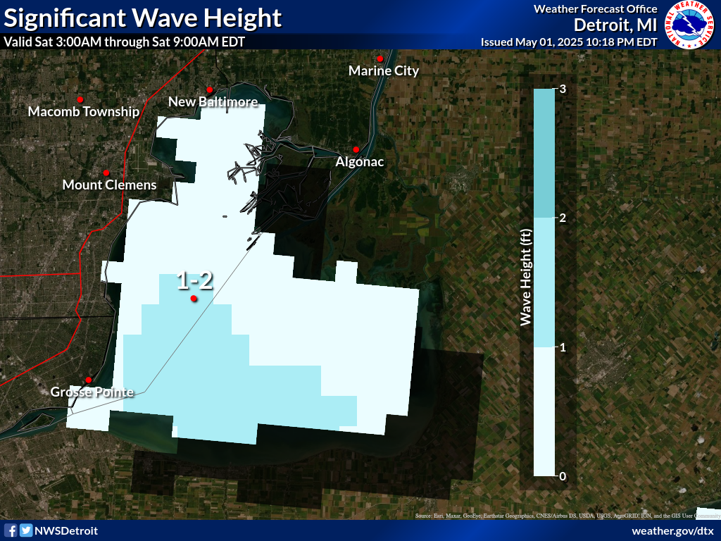
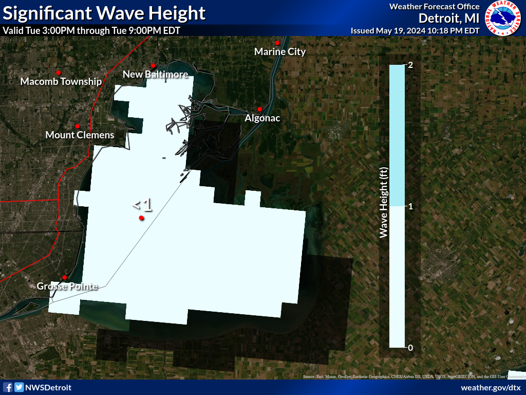
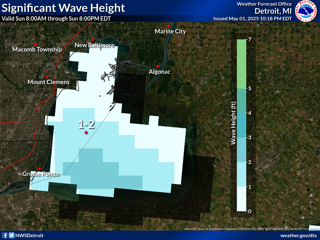
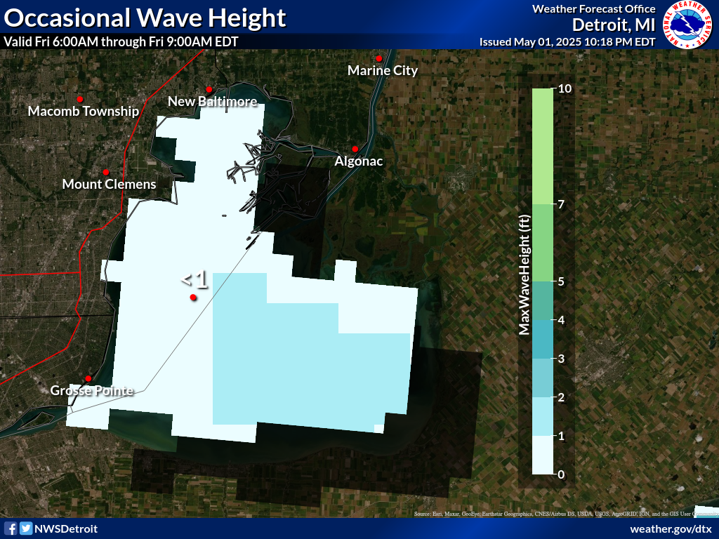
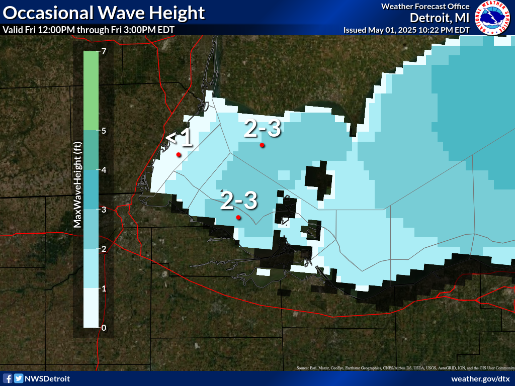
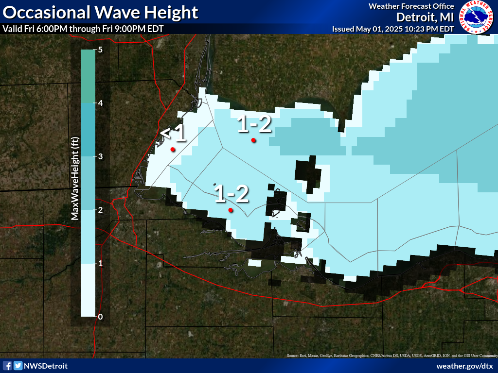
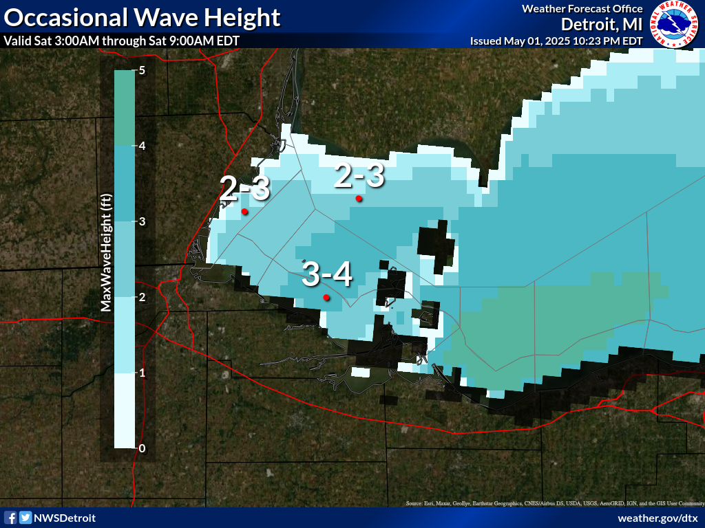
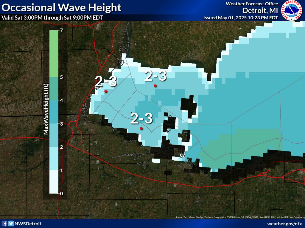
LCZ460-142130-
Lake St Clair-
928 AM EDT Tue Jul 14 2026
.REST OF TODAY...Southwest winds 5 to 15 knots. Mostly sunny.
Waves 2 feet or less.
.TONIGHT...Southwest winds 5 to 10 knots becoming west 10 to 15
knots in the late evening and overnight. Mostly clear. Waves 2 feet
or less.
.WEDNESDAY...Northwest winds 5 to 10 knots early in the morning
becoming light and variable...then becoming northeast 5 to 10 knots
early in the afternoon. Mostly sunny. Waves 2 feet or less.
.WEDNESDAY NIGHT...Northeast winds 10 to 15 knots diminishing to 5
to 10 knots in the late evening and overnight. Mostly clear. Waves 2
feet or less.
.THURSDAY...North winds 5 to 10 knots. Mostly clear. Waves 2 feet or
less.
.FRIDAY...East winds 5 to 10 knots. Mostly clear. Waves 2 feet or
less.
.SATURDAY...West winds 10 to 15 knots. Partly cloudy. Showers likely
and a chance of thunderstorms. Waves 2 feet or less.
$$
SF
Experimental modernized open lake forecast is available online at
weather.gov/dtx/glftablesc
Graphical marine forecasts are available at weather.gov/greatlakes
Toledo |
Marblehead |
(click to enlarge)
| through tomorrow | ||||||
Significant |
 |
 |
 |
 |
 |
 |
Occasional(top 10%) |
 |
 |
 |
 |
 |
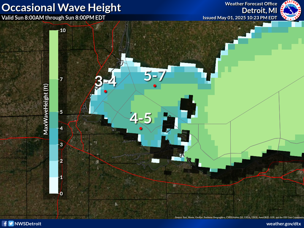 |
(click image to go to GLERL GLCFS)
584
FZUS61 KCLE 141353
GLFLE
Open Lake Forecast for Lake Erie
National Weather Service Cleveland OH
953 AM EDT Tue Jul 14 2026
For waters beyond five nautical miles of shore on Lake Erie
Waves are the significant wave height - the average of the highest
1/3 of the wave spectrum. Occasional wave height is the average of
the highest 1/10 of the wave spectrum.
.SYNOPSIS...
High pressure 30.20 inches continues to build across the Great
Lakes region and into the Ohio Valley through Wednesday. A cold
front will move south across Lake Erie on Wednesday night with a
secondary cold front pushing south on Saturday.
LEZ162-163-142015-
Detroit River Lt. to Maumee Bay OH to Reno Beach OH beyond 5NM
offshoreline to US-Canadian border-
Reno Beach to The Islands OH beyond 5NM off shoreline to US-
Canadian border-
953 AM EDT Tue Jul 14 2026
.THIS AFTERNOON...West winds 5 to 10 knots becoming southwest.
Waves 1 foot or less.
.TONIGHT...Southwest winds around 10 knots becoming west. Waves
2 feet or less.
.WEDNESDAY...West winds 5 to 10 knots becoming southwest. Waves
2 feet or less.
.WEDNESDAY NIGHT...Southwest winds 5 to 10 knots becoming
northeast. Waves 1 foot or less.
.THURSDAY...Northeast winds 10 knots or less becoming east. Waves
1 foot or less.
.FRIDAY...East winds 5 to 10 knots becoming southeast. A chance
of showers and thunderstorms. Waves 2 feet or less.
.SATURDAY...South winds 10 to 15 knots becoming west. A chance of
showers and thunderstorms during the day, then showers likely
with a chance of thunderstorms Saturday night. Waves 1 to 3 feet.
Winds and waves higher in and near thunderstorms.
$$
LEZ164>166-142015-
The Islands to Vermilion OH beyond 5 nm off shoreline to US-
Canadian border-
Vermilion to Avon Point OH beyond 5 nm off shoreline to US-
Canadian border-
Avon Point to Willowick OH beyond 5 nm off shoreline to US-
Canadian border-
953 AM EDT Tue Jul 14 2026
.THIS AFTERNOON...West winds 10 to 15 knots becoming southwest.
Waves 1 to 3 feet.
.TONIGHT...Southwest winds 10 to 15 knots becoming west. Waves
1 to 3 feet.
.WEDNESDAY...West winds 5 to 15 knots. Waves 1 to 3 feet.
.WEDNESDAY NIGHT...West winds 5 to 10 knots becoming northeast.
Waves 1 foot or less.
.THURSDAY...Northeast winds 10 knots or less becoming east. Waves
1 foot or less.
.FRIDAY...East winds 5 to 10 knots becoming southeast. A chance
of showers and thunderstorms Friday night. Waves 1 foot or less
building to 1 to 3 feet.
.SATURDAY...South winds 10 to 15 knots becoming west 15 to
20 knots. A chance of showers and thunderstorms during the day,
then showers likely with a chance of thunderstorms Saturday
night. Waves 2 to 4 feet subsiding to 1 to 3 feet.
Winds and waves higher in and near thunderstorms.
$$
LEZ061-167>169-142015-
Ripley to Buffalo NY extending from 5NM off shoreline to US-
Canadian border-Willowick to Geneva-on-the-
Lake OH beyond 5NM off shoreline to US-Canadian border-Geneva-on-
the-Lake to Conneaut OH beyond 5 nm off shoreline to US-
Canadian border-
Conneaut OH to Ripley NY beyond 5 nm off shoreline to US-
Canadian border-
953 AM EDT Tue Jul 14 2026
.THIS AFTERNOON...Southwest winds 15 to 20 knots. Waves 2 to
4 feet building to 3 to 6 feet.
.TONIGHT...Southwest winds 15 to 20 knots becoming west 10 to
15 knots. Waves 3 to 6 feet.
.WEDNESDAY...West winds 5 to 15 knots. Waves 2 to 4 feet
subsiding to 1 to 3 feet.
.WEDNESDAY NIGHT...West winds 5 to 10 knots becoming north. Waves
2 feet or less.
.THURSDAY...Northwest winds 5 to 10 knots becoming north. Waves
1 foot or less.
.FRIDAY...Northeast winds 5 to 10 knots becoming southeast. A
chance of showers Friday night. Waves 1 foot or less building to
1 to 3 feet.
.SATURDAY...South winds 5 to 15 knots becoming northwest 15 to
20 knots. A chance of showers and thunderstorms during the day,
then showers likely with a chance of thunderstorms Saturday
night. Waves 2 to 4 feet subsiding to 1 to 3 feet.
Winds and waves higher in and near thunderstorms.
$$
LEZ161-142015-
MAFOR 1415/
ERIE WEST 1/3 14510 13610 11600. Waves 2 feet or less this
afternoon. Waves 1 to 3 feet tonight. Waves 2 feet or less
Wednesday morning.
ERIE CENTRAL 1/3 11510 12520 11510 13610 11600. Waves 1 to 3 feet
building to 2 to 4 feet this afternoon. Waves 2 to 4 feet
tonight. Waves 1 to 3 feet Wednesday morning.
ERIE EAST 1/3 14520 11510 11610 12600. Waves 2 to 4 feet building
to 3 to 6 feet this afternoon. Waves 3 to 6 feet tonight. Waves 2
to 4 feet Wednesday morning.
$$
Prototype: Under Development: Not to be relied on for Operational Decision Making.