
Dangerous heat will expand from the Gulf Coast into the Southern Plains and Desert Southwest through week's end. Additional extreme heat impacting the Pacific Northwest will shift to the northern Plains by the weekend. Tropical Storm Bertha is expected to continue to impact portions of the northern Gulf Coast from the western Florida Panhandle to southeastern Louisiana through tonight. Read More >
November 1, 2020 - High Wind, Lakeshore Flooding, and Beach Erosion Event
|
A strong Upper level trough oved through the Great Lakes region on November 1st, 2020. This brought cold air advection and steep low level lapse rates that caused wind gusts to be 50 to 60 mph at times. Along with this push of cold air across the lake, waves reached as high as 12 to 16 feet. This high wave action caused minor flooding along the lake shore and over the piers. |
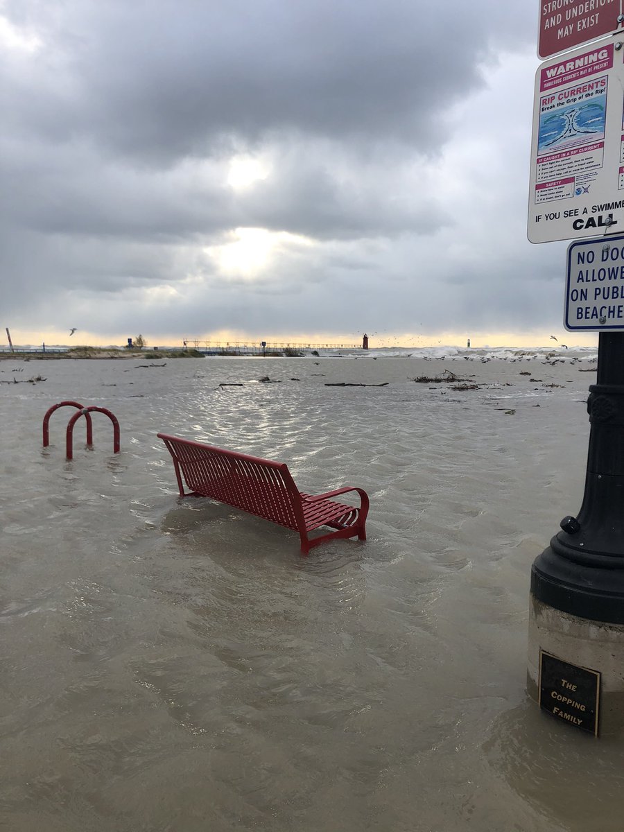 Winds as high as 60 mph pushed waves onshore which caused minor flooding along Lake Michigan as well as some beach and dune erosion. The picture above is North Beach at South Haven. Image courtesy of Issac Polanski |
 |
 |
|
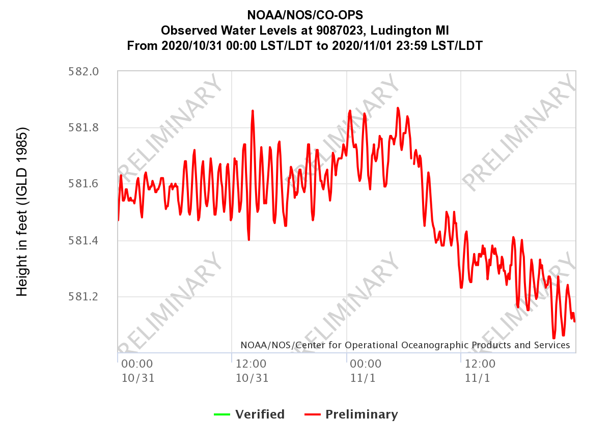
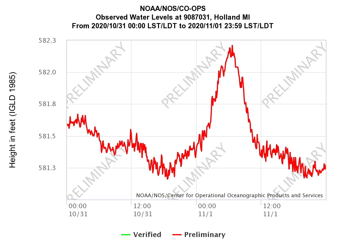
| Water Levels Ludington, MI | Winds and Waves at South Haven | Water Levels Holland, MI |
Storm Reports
Wind and Wave Reports
Increased winds brought strong waves bringing increased water level peaking in the afternoon at Holland and Ludington.
Wind and Wave Reports
PRELIMINARY LOCAL STORM REPORT...SUMMARY
NATIONAL WEATHER SERVICE GRAND RAPIDS MI
1120 AM EST MON NOV 2 2020

..TIME...   ...EVENT...      ...CITY LOCATION...     ...LAT.LON...
..DATE...   ....MAG....      ..COUNTY LOCATION..ST.. ...SOURCE....
            ..REMARKS..

0900 AM     NON-TSTM WND GST 1 W SOUTH HAVEN         42.40N 86.29W
11/01/2020  M51 MPH          LMZ844             MI   MESONET

            MESONET STATION SVNM4 SOUTH HAVEN.

0730 AM     NON-TSTM WND GST 1 W SOUTH HAVEN         42.40N 86.29W
11/01/2020  M49 MPH          LMZ844             MI   MESONET

            MESONET STATION SVNM4 SOUTH HAVEN.

0330 AM     NON-TSTM WND GST 6 W LUDINGTON           43.95N 86.55W
11/01/2020  M47 MPH          LMZ868             MI   MESONET

            MESONET STATION 45024 5 W LUDINGTON.

1100 PM     NON-TSTM WND GST 6 W LUDINGTON           43.95N 86.55W
10/31/2020  M43 MPH          LMZ868             MI   MESONET

            MESONET STATION 45024 5 W LUDINGTON.

1024 AM     NON-TSTM WND GST 4 WNW ROOSEVELT PARK    43.22N 86.35W
11/01/2020  M60 MPH          LMZ847             MI   MESONET

            MESONET STATION XMSK MUSKEGON NORTH
            BREAKWATER LIGHT.

0733 AM     NON-TSTM WND GST 4 WNW ROOSEVELT PARK    43.22N 86.35W
11/01/2020  M59 MPH          LMZ847             MI   MESONET

            MESONET STATION XMSK MUSKEGON NORTH
            BREAKWATER LIGHT.

0104 AM     NON-TSTM WND GST 4 WNW ROOSEVELT PARK    43.22N 86.35W
11/01/2020  M50 MPH          LMZ847             MI   MESONET

            MESONET STATION XMSK MUSKEGON NORTH
            BREAKWATER LIGHT.

1054 PM     NON-TSTM WND GST 4 WNW ROOSEVELT PARK    43.22N 86.35W
10/31/2020  M49 MPH          LMZ847             MI   MESONET

            MESONET STATION XMSK MUSKEGON NORTH
            BREAKWATER LIGHT.

0909 AM     NON-TSTM WND GST 2 NNW SAUGATUCK         42.68N 86.22W
11/01/2020  M54 MPH          LMZ845             MI   MESONET

            MESONET STATION XSTK SAUGATUCK PIER.

0717 AM     NON-TSTM WND GST 2 NNW SAUGATUCK         42.68N 86.22W
11/01/2020  M53 MPH          LMZ845             MI   MESONET

            MESONET STATION XSTK SAUGATUCK PIER.

0111 AM     NON-TSTM WND GST 2 NNW SAUGATUCK         42.68N 86.22W
11/01/2020  M47 MPH          LMZ845             MI   MESONET

            MESONET STATION XSTK SAUGATUCK PIER.

0946 AM     NON-TSTM WND GST 2 W GRAND HAVEN         43.06N 86.26W
11/01/2020  M60 MPH          LMZ846             MI   MESONET

            MESONET STATION XGHL GRAND HAVEN LIGHT.

0909 AM     NON-TSTM WND GST 2 W GRAND HAVEN         43.06N 86.26W
11/01/2020  M55 MPH          LMZ846             MI   MESONET

            MESONET STATION XGHL GRAND HAVEN LIGHT.

0752 AM     NON-TSTM WND GST 2 W GRAND HAVEN         43.06N 86.26W
11/01/2020  M55 MPH          LMZ846             MI   MESONET

            MESONET STATION XGHL GRAND HAVEN LIGHT.

1233 AM     NON-TSTM WND GST 2 W GRAND HAVEN         43.06N 86.26W
11/01/2020  M50 MPH          LMZ846             MI   MESONET

            MESONET STATION XGHL GRAND HAVEN LIGHT.

1031 PM     NON-TSTM WND GST 2 W GRAND HAVEN         43.06N 86.26W
10/31/2020  M45 MPH          LMZ846             MI   MESONET

            MESONET STATION XGHL GRAND HAVEN LIGHT.

0338 PM     NON-TSTM WND GST 1 SSE SPRINGFIELD       42.32N 85.23W
11/01/2020  M39 MPH          CALHOUN            MI   ASOS

            ASOS STATION KBTL BATTLE CREEK EXECUTIVE
            AIRPORT.

0338 PM     NON-TSTM WND GST 3 NNE EDGEMONT PARK     42.78N 84.58W
11/01/2020  M43 MPH          CLINTON            MI   ASOS

            ASOS STATION KLAN LANSING.

0300 PM     LAKESHORE FLOOD  1 NW GANGES             42.59N 86.23W
11/01/2020                   ALLEGAN            MI   PUBLIC

            COLLAPSE OF RETAINING WALL MEANT TO KEEP
            WATER AWAY FROM PROPERTY NEAR PIER COVE ON
            LAKE MICHIGAN. FULL EXTENT OF DAMAGE
            UNKNOWN. TIME IS ESTIMATED.

0300 PM     LAKESHORE FLOOD  1 WNW SOUTH HAVEN       42.40N 86.28W
11/01/2020                   VAN BUREN          MI   PUBLIC

            SIGNIFICANT FLOODING OF A PARK ADJACENT TO
            NORTH BEACH IN SOUTH HAVEN. TIME IS
            ESTIMATED.

0256 PM     NON-TSTM WND GST 3 ENE SANDSTONE         42.27N 84.47W
11/01/2020  M38 MPH          JACKSON            MI   ASOS

            ASOS STATION KJXN JACKSON COUNTY-REYNOLDS
            FIELD AIRPORT.

0255 PM     NON-TSTM WND GST 1 ENE NORTON SHORES     43.17N 86.23W
11/01/2020  M46 MPH          MUSKEGON           MI   ASOS

            ASOS STATION KMKG MUSKEGON COUNTY AIRPORT.

0253 PM     NON-TSTM WND GST 3 NE PORTAGE            42.23N 85.55W
11/01/2020  M36 MPH          KALAMAZOO          MI   ASOS

            ASOS STATION KAZO KZOO/BATTLE CREEK INTL
            AIRPORT.

0253 PM     NON-TSTM WND GST 2 SSW CASCADE           42.88N 85.52W
11/01/2020  M43 MPH          KENT               MI   ASOS

            ASOS STATION KGRR GERALD R FORD INTL.

0253 PM     NON-TSTM WND GST 2 S HOLLAND             42.75N 86.10W
11/01/2020  M46 MPH          ALLEGAN            MI   ASOS

            ASOS STATION KBIV W MICH REGIONAL ARPT.

0909 AM     NON-TSTM WND GST EAST GRAND RAPIDS       42.95N 85.61W
11/01/2020  M46 MPH          KENT               MI   CO-OP OBSERVER


0830 AM     NON-TSTM WND GST 4 WNW ROOSEVELT PARK    43.23N 86.34W
11/01/2020  M52 MPH          MUSKEGON           MI   MESONET

            MESONET STATION MKGM4 3 WNW ROOSEVELT PARK.

0817 AM     NON-TSTM WND GST 1 SSW EAST GRAND RAPIDS 42.94N 85.61W
11/01/2020  E42 MPH          KENT               MI   CO-OP OBSERVER

            .

0746 AM     NON-TSTM WND GST 1 SSE SPRINGFIELD       42.32N 85.23W
11/01/2020  M41 MPH          CALHOUN            MI   ASOS

            ASOS STATION KBTL BATTLE CREEK EXECUTIVE
            AIRPORT.

0740 AM     NON-TSTM WND GST 4 WNW ROOSEVELT PARK    43.23N 86.34W
11/01/2020  M51 MPH          MUSKEGON           MI   MESONET

            MESONET STATION MKGM4 3 WNW ROOSEVELT PARK.

0738 AM     NON-TSTM WND GST 3 NE PORTAGE            42.23N 85.55W
11/01/2020  M40 MPH          KALAMAZOO          MI   ASOS

            ASOS STATION KAZO KZOO/BATTLE CREEK INTL
            AIRPORT.

0736 AM     NON-TSTM WND GST MACATAWA                42.77N 86.20W
11/01/2020  M53 MPH          OTTAWA             MI   BUOY

            BUOY STATION HLNM4 HOLLAND HARBOR.

0733 AM     NON-TSTM WND GST 5 SW WHITEHALL          43.37N 86.42W
11/01/2020  M55 MPH          MUSKEGON           MI   MESONET

            MESONET STATION DW2963 WHITEHALL.

0732 AM     NON-TSTM WND GST 1 ENE NORTON SHORES     43.17N 86.23W
11/01/2020  M48 MPH          MUSKEGON           MI   ASOS

            ASOS STATION KMKG MUSKEGON COUNTY AIRPORT.

0640 AM     NON-TSTM WND GST 3 NE SHELBY             43.64N 86.33W
11/01/2020  M40 MPH          OCEANA             MI   AWOS

            AWOS STATION C049 2 NE SHELBY.

0627 AM     NON-TSTM WND GST 3 ENE SANDSTONE         42.27N 84.47W
11/01/2020  M40 MPH          JACKSON            MI   ASOS

            ASOS STATION KJXN JACKSON COUNTY-REYNOLDS
            FIELD AIRPORT.

0413 AM     NON-TSTM WND GST 3 NNE EDGEMONT PARK     42.78N 84.58W
11/01/2020  M45 MPH          CLINTON            MI   ASOS

            ASOS STATION KLAN LANSING.

0259 AM     NON-TSTM WND GST 2 S HOLLAND             42.75N 86.10W
11/01/2020  M46 MPH          ALLEGAN            MI   ASOS

            ASOS STATION KBIV W MICH REGIONAL ARPT.

0116 AM     NON-TSTM WND GST 5 SW WHITEHALL          43.37N 86.42W
11/01/2020  M51 MPH          MUSKEGON           MI   MESONET

            MESONET STATION DW2963 WHITEHALL.

0116 AM     NON-TSTM WND GST 5 SW WHITEHALL          43.37N 86.42W
11/01/2020  M51 MPH          MUSKEGON           MI   MESONET

            MESONET STATION DW2963 WHITEHALL.

1236 AM     NON-TSTM WND GST MACATAWA                42.77N 86.20W
11/01/2020  M49 MPH          OTTAWA             MI   BUOY

            BUOY STATION HLNM4 HOLLAND HARBOR.

1215 AM     NON-TSTM WND GST 1 SSE REEMAN            43.43N 86.00W
11/01/2020  M45 MPH          NEWAYGO            MI   AWOS

            AWOS STATION KFFX FREMONT MUNICIPAL ARPT.

1200 AM     NON-TSTM WND GST 4 WNW ROOSEVELT PARK    43.23N 86.34W
11/01/2020  M51 MPH          MUSKEGON           MI   MESONET

            MESONET STATION MKGM4 3 WNW ROOSEVELT PARK.

1110 PM     NON-TSTM WND GST 4 WNW ROOSEVELT PARK    43.23N 86.34W
10/31/2020  M47 MPH          MUSKEGON           MI   MESONET

            MESONET STATION MKGM4 3 WNW ROOSEVELT PARK.

1045 PM     NON-TSTM WND GST 5 SW WHITEHALL          43.37N 86.42W
10/31/2020  M40 MPH          MUSKEGON           MI   MESONET

            MESONET STATION DW2963 WHITEHALL.

1045 PM     NON-TSTM WND GST 5 SW WHITEHALL          43.37N 86.42W
10/31/2020  M40 MPH          MUSKEGON           MI   MESONET

            MESONET STATION DW2963 WHITEHALL.

1000 PM     NON-TSTM WND GST 3 NE PENTWATER          43.81N 86.38W
10/31/2020  M47 MPH          OCEANA             MI   MESONET

            MESONET STATION EW6978 PENTWATER
Thank you to everyone who submitted damage reports, photos, and videos!
 |
Media use of NWS Web News Stories is encouraged! Please acknowledge the NWS as the source of any news information accessed from this site. |
|

