
Dry and windy conditions will bring widespread fire weather concerns to the northern/central Plains and portions of the Southwest into the southern Plains. Severe thunderstorms with large hail and damaging wind gusts are possible over the central Plains today into this weekend. Rain and high elevation snow is expected over parts of the Cascades and Northern Intermountain Region through Saturday. Read More >
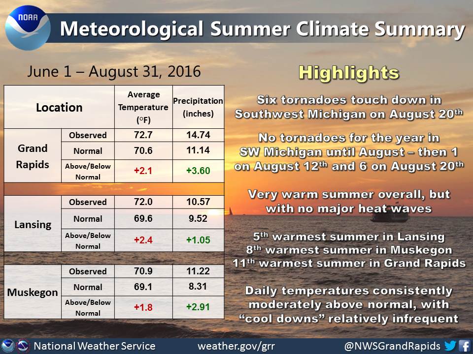
Meteorological summer, which we define as June 1 - August 31, has ended. Here's a look at some of the highlights and climate stats of Summer 2016.
Daily temperatures were consistently moderately above normal, with cool downs during the latter half of summer becoming less frequent and less significant. This resulted in very warm average temperatures for the season. Lansing actually tied their 5th warmest summer since 1863 (1949 and 1921).
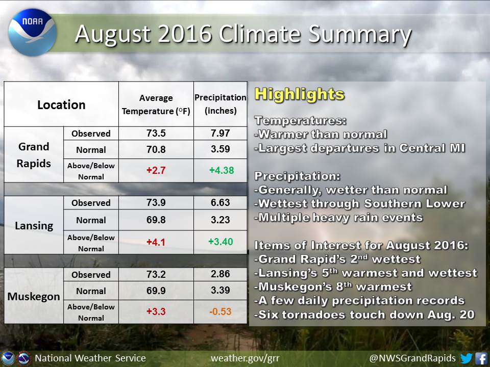
Vegetation began to show signs of the onset of drought during the second half of June, but that was alleviated quickly for most areas with some even seeing minor flooding in August. In fact, Grand Rapids recorded its 2nd wettest August since records began in 1892. It was the 5th wettest August on record in Lansing (since 1863), after the city had its 3rd driest June on record.
Finally, meteorological summer is the peak of the severe weather season in Michigan. There had been no tornadoes this year in Southwest Michigan until August. Then our area had one tornado on August 12th and six tornadoes on August 20th. A complete summary of the August 20th tornadoes can be found here: https://www.weather.gov/grr/summary20160820
A complete summary of the August 20th tornadoes can be found here: https://www.weather.gov/grr/summary20160820
August 2016 will be remembered for the six tornadoes that affected Southwest Lower Michigan on Saturday, August 20th. In the early afternoon hours of the 20th, three separate EF-1 tornadoes impacted Van Buren, Allegan and Ottawa Counties. A multitude of trees sustained significant damage from these three tornadoes and some structural damage occurred in Bangor, Michigan. The day's third tornado tracked from far Northern Allegan County into extreme Southeast Ottawa County. Two EF-0 tornadoes occurred in Kent County. The first sliced through Grandville and Wyoming. The second EF-0 in Kent County touched down near Perkins Avenue in Northeast Grand Rapids. In addition to the two tornadoes, significant straight-line wind damage occurred from Grandville into East Grand Rapids. The sixth tornado was an EF-1, which impacted Ionia and Montcalm Counties.
In terms of general climate trends, August 2016 was warmer and wetter than average across Southwest Lower Michigan. Grand Rapids recorded its 2nd wettest August since records began in 1892. Grand Rapids set daily rainfall records on August 12th and August 16th. A whopping 2.61 inches of rain fell in Grand Rapids on August 12th. Lansing set a daily rainfall record on August 16th. Lansing tied the daily record for the warmest low temperature of 74 degrees on August 12th.
Average temperature was consistently above normal throughout August 2016. Most days featured highs in the 80s and 90s with lows in the 60s and occasionally the 70s. Only a few days featured high temperatures below 80 degrees.
 |
Media use of NWS Web News Stories is encouraged! |
|

