
Record setting heat is expected over the next several days from the Intermountain West through the northern Plains. Furthermore, fire weather concerns increase with dry and breezy conditions. Meanwhile, heavy rainfall and severe thunderstorm threats for the Ohio/Tennessee Valleys, central Appalachians and Southeast today. The threat shifts to central Gulf Coast and across central Texas this week. Read More >
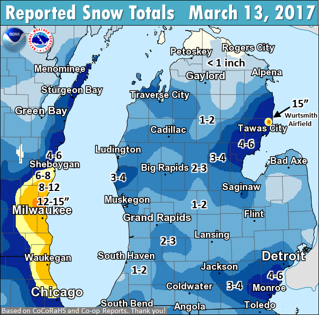
March 13's snow totals. A result of light area-wide snow from a weather system, plus locally heavy lake-effect amid east winds. Milwaukee and Oscoda received up to 15 inches.
Note: Map is a "best guess" based on a limited number of volunteer CoCoRaHS and Co-op observer reports. Thanks to everyone who reported their totals during and after this event!
            SNOW REPORTS

LOCATION                   OBSERVED     TIME/DATE
                            VALUE     OF OBSERVATION    LAT    LON
MICHIGAN

...ALLEGAN COUNTY...
  5 E PLAINWELL                2.2 M   800 AM 03/14   42.44N  85.54W
  2 N HOPKINS                  2.4 M   800 AM 03/14   42.65N  85.76W

...CLARE COUNTY...
  5 ESE HARRISON               2.7 M   800 AM 03/14   43.99N  84.71W

...EATON COUNTY...
  4 WNW LANSING                1.0 M   700 AM 03/14   42.76N  84.62W

...GRATIOT COUNTY...
  BRECKENRIDGE                 3.2 M   700 AM 03/14   43.41N  84.48W

...INGHAM COUNTY...
  1 N HASLETT                  1.6 M   700 AM 03/14   42.76N  84.40W
  4 NW RIVES JUNCTION          2.3 M   900 AM 03/14   42.43N  84.52W

...IONIA COUNTY...
  3 NE SARANAC                 1.6 M   630 AM 03/14   42.96N  85.17W

...ISABELLA COUNTY...
  4 SSE SHEPHERD               1.9 M   600 AM 03/14   43.47N  84.66W

...JACKSON COUNTY...
  3 W JACKSON                  3.0 M   515 AM 03/14   42.25N  84.47W

...KALAMAZOO COUNTY...
  6 SW KALAMAZOO               2.6 M   815 AM 03/14   42.22N  85.68W

...KENT COUNTY...
  1 NNE ROCKFORD               1.2 M   900 AM 03/14   43.13N  85.55W
  5 ESE ROCKFORD               1.7 M   745 AM 03/14   43.09N  85.47W
  4 NNE COMSTOCK PARK          1.9 M   600 AM 03/14   43.09N  85.64W
  2 ENE GRAND RAPIDS           2.0 M   700 AM 03/14   42.97N  85.63W
  1 SSW EAST GRAND RAPIDS      2.6 M   700 AM 03/14   42.93N  85.62W
  2 W ADA                      2.6 M   400 AM 03/14   42.95N  85.53W

...LMZ848 COUNTY...
  8 NW MONTAGUE                2.8 M   700 AM 03/14   43.50N  86.47W

...MASON COUNTY...
  7 WNW SCOTTVILLE             2.1 M   500 AM 03/14   43.99N  86.41W

...MECOSTA COUNTY...
  5 S BIG RAPIDS               2.3 M   700 AM 03/14   43.62N  85.48W
  5 SSW MECOSTA                2.6 M   800 AM 03/14   43.55N  85.27W

...OCEANA COUNTY...
  3 WSW HART                   3.6 M   700 AM 03/14   43.68N  86.42W

...OTTAWA COUNTY...
  3 W HOLLAND                  1.2 M   715 AM 03/14   42.78N  86.17W
  4 NNW HOLLAND                1.8 M   700 AM 03/14   42.84N  86.14W
  SSW ALLENDALE                2.1 M   800 AM 03/14   42.97N  85.95W

...VAN BUREN COUNTY...
  4 NNE PAW PAW                0.8 M   700 AM 03/14   42.27N  85.86W
This spring's weather spotter training schedule has been posted: weather.gov/grr/spottertraining
 |
Media use of NWS Web News Stories is encouraged! |
|

