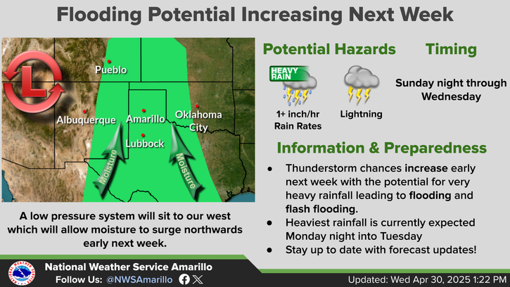
National Weather Service United States Department of Commerce

Severe Thunderstorms and Heavy Rain in the Central Plains and Midwest; Heat Pushes into the South and East

Scattered severe thunderstorms capable of large hail in excess of two inches, strong tornadoes, and damaging wind gusts are likely across parts of the Upper Mississippi Valley and Midwest this evening. Heavy to excessive rainfall may bring a flooding threat to portions of the Central Plains to the Midwest through Thursday. The heatwave in the Central U.S. will begin to push South and East Thursday Read More >

Click a location below for detailed forecast.

Last Map Update: Thu, Jun 11, 2026 at 8:46:25 am CDT

There are very low (10-20%) chances for a storm or two across the southeast this evening ahead of a cold front. These storms could be severe with large hail and damaging wind gusts if they form near Wellington. Additional storms may form very early Friday morning and these storms could become strong to potentially severe, with the primary hazard being large hail if severe storms form. The storm hazards and development overnight are uncertain, so keep up to date with any forecast changes.
Forecast high temperatures should be a bit cooler than they were yesterday with less locations reaching the triple digit mark. A weak cold front will move across the Panhandles today leading to these cooler temperatures.
Storm chances continue each day this weekend, with the highest chances being on Saturday afternoon into the evening. Some of the storms on any of the days this weekend could become strong to severe. Temperatures will remain warm on Friday and Saturday, but will cool off on Sunday behind a stronger cold front.
Hot triple digit heat is expected to continue over Palo Duro Canyon for the next several days. Obey park rules and be prepared for the scorching heat! Hot temperatures are likely to exist even into the evening hours.

Text Product Selector (Selected product opens in current window)


Current Observations ( )
Location Sky/Weather Temp (°F) Dewpt (°F) RH (%) Wind (mph) Pressure (inHg) Remarks
 Amarillo
N/A
N/A
N/A
N/A
N/A
N/A
N/A
 Borger
N/A
N/A
N/A
N/A
N/A
N/A
N/A
 Canadian
N/A
N/A
N/A
N/A
N/A
N/A
N/A
 Dalhart
N/A
N/A
N/A
N/A
N/A
N/A
N/A
 Dumas
N/A
N/A
N/A
N/A
N/A
N/A
N/A
 Guymon
N/A
N/A
N/A
N/A
N/A
N/A
N/A
 Hereford
N/A
N/A
N/A
N/A
N/A
N/A
N/A
 Pampa
N/A
N/A
N/A
N/A
N/A
N/A
N/A
 Perryton
N/A
N/A
N/A
N/A
N/A
N/A
N/A
 Amarillo 9NNE
N/A
N/A
N/A
N/A
N/A
N/A
N/A
 Amarillo 7SSE
N/A
N/A
N/A
N/A
N/A
N/A
N/A
 Bootleg 11WNW
N/A
N/A
N/A
N/A
N/A
N/A
N/A
 Canadian 6E
N/A
N/A
N/A
N/A
N/A
N/A
N/A
 Clarendon 2WSW
N/A
N/A
N/A
N/A
N/A
N/A
N/A
 Claude 12SW
N/A
N/A
N/A
N/A
N/A
N/A
N/A
 Hereford 2NW
N/A
N/A
N/A
N/A
N/A
N/A
N/A
 McLean 1E
N/A
N/A
N/A
N/A
N/A
N/A
N/A
 Palo Duro SP
N/A
N/A
N/A
N/A
N/A
N/A
N/A
 Pampa 2E
N/A
N/A
N/A
N/A
N/A
N/A
N/A
 Umbarger 3NNE
N/A
N/A
N/A
N/A
N/A
N/A
N/A
Note: "N/A" or "MISG" will be displayed if values are not available. In the LOCATION column, click on links for a list of recent observations at sites of interest. In the WIND column, VRB is "variable" and G is "gust". In the REMARKS column, HX is "heat index", WCI is "wind chill index", and VSB is "visibility" (if shown).


Aviation Drought Fire Weather Hydrology Severe Weather Winter Weather
 
Climate Graphs Hourly Forecast Long Range Local Model Data Precip Maps Heat
 
Education Local Research News Skywarn Weather Calculator Weather Radio