Overview
A combination of synoptic snow and lake effect banding characterized the first winter precipitation of the 2025-2026 winter season. Snow initially began during the early morning hours of Sunday, November 9th as low pressure deepened while tracking across the Ohio Valley. SE Michigan was favorably positioned for cooler temperatures within the northern quadrants of the low. Models were initially forecasting a sharp band of frontogenesis to develop over the area, but ultimately the forcing and moisture prospects settled toward a more standard light/steady snowfall for most of the morning hours. Most areas saw around 1 to 2 inches of snow accumulation by mid-day. As the low moved east toward New England, a very cold airmass surged across the Great Lakes while cyclonic north-northeast flow across Lake Huron began to induce a lake response. The lake effect response with this system stole the show in terms of snowfall amounts, in which two convergence axes led to advisory-level snowfall Sunday-Sunday night. The first was downwind of Saginaw Bay, which is a less common lake effect setup in the DTX CWA, in which banding started to develop late in the morning and persisted until flow shifted more northerly Sunday evening. When all was said and done, storm total accumulations were around 2-5 inches under the most intense snow bands. The other location of interest was downwind of southern Lake Huron toward St. Clair and Macomb Counties, where a more organized/linear lake effect snow band developed overnight. Snow accumulations in this area were around 3 to 5 inches by Monday morning.
Some of the challenges with this forecast included warm ground temperatures and air temperatures near freezing, which generally melted the snow in areas that did not see lake effect. There were also questions as to how the warm waters of Lake Huron would impact snow-to-liquid ratios in the lake effect bands. For reference, 24-hour liquid precipitation amount was 0.29" at MBS.
Snow Totals
Public Information Statement...Summary
National Weather Service Detroit/Pontiac MI
603 PM EST Nov 10 2025

...SNOWFALL REPORTS...

Location                     Amount    Time/Date

...Michigan...

...Bay County...
1 NE Bay City                1.9 in    0600 AM 11/10

...Genesee County...
Flint Bishop Airport         1.6 in    1203 AM 11/10
3 WSW Flint                  1.0 in    0700 AM 11/10

...Huron County...
Ubly                         7.5 in    0500 PM 11/10
Bad Axe                      5.0 in    0500 PM 11/10
1 E Port Austin              1.0 in    0830 AM 11/10

...Macomb County...
New Baltimore                5.2 in    0800 AM 11/10
2 W Saint Clair Shores       3.4 in    0737 AM 11/10
2 SW Memphis                 3.0 in    0800 AM 11/10
Eastpointe                   2.5 in    0600 AM 11/10
4 NE Warren                  2.3 in    0800 AM 11/10
2 NNW Saint Clair Shores     2.0 in    0500 AM 11/10
2 E Roseville                2.0 in    0500 AM 11/10
2 N Sterling Heights         1.5 in    0653 AM 11/10
Shelby                       1.0 in    0700 AM 11/10

...Monroe County...
1 SE Dundee                  3.0 in    0800 AM 11/10
1 S Ottawa Lake              2.0 in    0700 AM 11/10

...Oakland County...
1 E Lake Orion               2.1 in    0600 AM 11/10
1 NE Clarkston               1.5 in    0700 AM 11/10
4 E White Lake               1.4 in    1201 AM 11/10

...Saginaw County...
2 SW Saginaw                 5.4 in    1200 AM 11/10
Shields                      4.5 in    0952 PM 11/09
8 NW Saginaw                 3.4 in    0748 PM 11/09
1 SW Saginaw                 2.0 in    0800 AM 11/10
6 W Saginaw                  2.0 in    0900 AM 11/10
1 SE Frankenmuth             1.7 in    0530 AM 11/10

...Sanilac County...
3 NW Croswell                3.0 in    0956 AM 11/10
Lexington                    1.0 in    0709 AM 11/10

...Shiawassee County...
6 W Durand                   2.0 in    0800 AM 11/10
1 NW Owosso                  1.3 in    0700 AM 11/10
2 SW Owosso                  1.2 in    0700 AM 11/10

...St. Clair County...
3 NW Marine City             5.6 in    0719 AM 11/10
Algonac                      4.0 in    0800 AM 11/10
3 W Port Huron               3.0 in    0700 AM 11/10

...Washtenaw County...
Ann Arbor Se                 1.9 in    0730 AM 11/10
7 W Ann Arbor                1.8 in    0700 AM 11/10
2 W Ann Arbor                1.5 in    0730 AM 11/10

...Wayne County...
Grosse Pointe                3.0 in    0800 AM 11/10
2 NE Riverview               2.5 in    0800 AM 11/10
Detroit Metro Airport        2.2 in    1202 AM 11/10
3 SE Detroit                 1.1 in    0900 AM 11/10

Observations are collected from a variety of sources with varying
equipment and exposures. We thank all volunteer weather observers
for their dedication. Not all data listed are considered official.

$$
|
|
|
Estimated snowfall totals across Southeast Michigan from November 9-10th, 2025. |
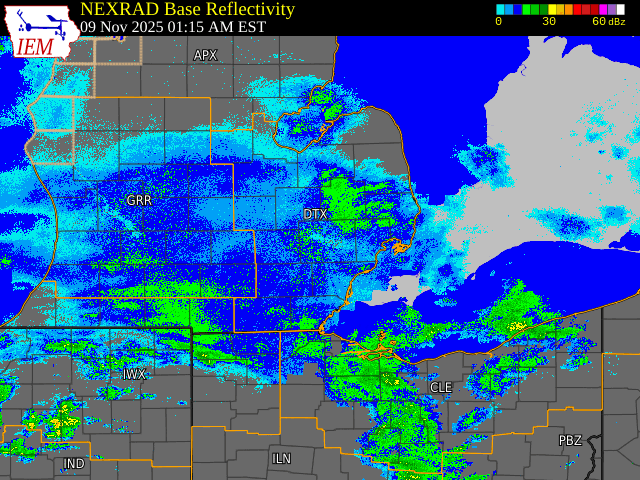
Radar
|
|
|
Radar: NEXRAD mosaic base reflectivity radar loop from November 9-10, 2025 |
Radar loop courtesy of Iowa Environmental Mesonet (IEM)
 |
Media use of NWS Web News Stories is encouraged! Please acknowledge the NWS as the source of any news information accessed from this site. |
|


.png)