
A significant heat wave is underway for the Intermountain West, Northern Plains, and Upper Great Lakes, peaking in intensity through midweek and lingering across parts of the Northern Plains and Midwest until this weekend. In southwest Texas, excessive rainfall may bring a risk for potentially life-threatening flash and arroyo flooding through Thursday. Read More >
March 10-11, 2026 Severe Weather Overview
|
A total of 6 tornadoes have been determined from the March 10-11 severe storms - 3 EF-1s & 3 EF-0s An unseasonably warm and humid airmass surged north during the afternoon of March 10th, pushing high temperatures into the upper 70s and lower 80s across central Illinois. Record highs were set at Springfield (84° F), Peoria (83° F), and Lincoln (82° F) -- all topping their previous highs set back in 1955. Late afternoon/early evening surface analysis showed a stationary front extending from southeast Iowa into northwest Indiana, with a sharp temperature gradient from north to south across the boundary. A highly unstable airmass was in place south of the boundary with low-level wind shear maximized just north of it. Thunderstorms were initially slow to develop due to a capping inversion and lack of upper-level support. As a shortwave trough tracked into the Upper Midwest late in the afternoon, the cap gradually eroded and the first supercell rapidly developed along the McLean/Woodford county line. This storm brought quarter-size hail (1" diameter) to far eastern Woodford county before lifting into Iroquois County and becoming significantly stronger as it curved eastward along the frontal boundary. It dropped destructive hail (4"+ diameter) north of Pontiac in Livingston County, then produced a long-track tornado that began in Kankakee County and continued into northwest Indiana. Further west, additional thunderstorms quickly developed along a stationary front. While most of these cells were just north of NWS Lincoln's county warning area, a couple strong to severe supercells tracked across northern Knox, Stark, and Marshall counties. Several reports of funnel clouds were received, with one EF-1 tornado determined near West Jersey near the Knox/Stark county line and two EF-0 tornadoes determined in central Stark county north of Toulon and northern Marshall county north of Lacon. Later that night, another round of storms developed from northeast Missouri into west-central Illinois along an advancing cold front. One of the thunderstorms produced strong downdraft winds estimated between 80-90 mph in Havana, causing extensive damage to trees and some buildings. The storms surged forward and spun up two EF-1 tornadoes east of Havana to Topeka (Macon County) and the other south of Forest City to Green Valley (Macon/Tazewell Counties). These tornadoes snapped several trees and power poles, overturned a few irrigation systems, and partially destroyed a horse barn. Storms continued into east-southeast Illinois during the overnight hours, producing scattered wind damage. heavy rain, and a another brief EF-0 tornado north of Yale in Jasper county. |
Tornadoes
Select a tornado from the table to zoom into the track and view more information. The default table view is limited to 8 tracks, but can be scrolled by a mouse wheel or dynamically expanded. Additionally, the table can fill the entire window by clicking the small circular expanding arrow icon at the very top right of the table and returned to its original size by clicking the button again. The side information panel that opens over the map can be closed using the "X" on the upper right corner of the pop-up. Zoom into the map and click damage points to see detailed information and pictures from the surveys.
|
NOTE: times shown below are local to your device's time zone. |

The Enhanced Fujita (EF) Scale classifies tornadoes into the following categories:
| EF0 Weak 65-85 mph |
EF1 Moderate 86-110 mph |
EF2 Significant 111-135 mph |
EF3 Severe 136-165 mph |
EF4 Extreme 166-200 mph |
EF5 Catastrophic 200+ mph |
 |
|||||
| Tornadoes that fail to impact any ratable damage indicators on the EF-Scale are rated EF-Unknown (EF-U) | |||||
Storm Reports
Preliminary Local Storm Report...Summary
National Weather Service Lincoln IL
938 PM CDT Wed Mar 11 2026

..TIME...   ...EVENT...      ...CITY LOCATION...     ...LAT.LON...
..DATE...   ....MAG....      ..COUNTY LOCATION..ST.. ...SOURCE....
            ..REMARKS..

0412 PM     Hail             6 SE Minonk             40.86N 88.95W
03/10/2026  M1.00 Inch       Woodford           IL   Emergency Mngr

            Near the intersection of 1800 North and 3100
            East.

0718 PM     Tstm Wnd Dmg     3 E Victoria            41.04N 90.04W
03/10/2026                   Knox               IL   Emergency Mngr

            Multiple power lines were blown down, a
            carport was snapped, and a shipping
            container was flipped into a house north of
            the IL-180 and IL-167 intersection.

0722 PM     Tstm Wnd Dmg     4 E Victoria            41.04N 90.01W
03/10/2026                   Knox               IL   Public

            Delayed report. Steel post in a concrete
            setting ripped out of the ground. Time
            estimated by radar.

0722 PM     Tstm Wnd Dmg     4 W West Jersey         41.03N 89.99W
03/10/2026                   Knox               IL   Public

            Delayed report. Shipping container type
            storage building flipped onto its side. Time
            estimated by radar.

0722 PM     Tstm Wnd Dmg     4 E Victoria            41.04N 90.01W
03/10/2026                   Knox               IL   Public

            Delayed report. Report with pictures of
            damage to a grain silo. Time estimated by
            radar.

0801 PM     Tornado          3 N Sparland            41.07N 89.44W
03/10/2026                   Marshall           IL   NWS Storm Survey

            Video evidence from an Illinois River barge
            operator confirmed the starting point of a
            tornado 3.5 miles NW of Lacon. The EF-0
            tornado crossed the IL river and continued
            eastward where it damaged numerous trees
            north of Lake Wildwood. Photo evidence from
            a spotter showed the tornado still occurring
            2 miles south of Magnolia before it
            dissipated just east of Highway 89 after
            12.6 miles.

0811 PM     Hail             Henry                   41.11N 89.36W
03/10/2026  E0.88 Inch       Marshall           IL   Trained Spotter


1147 PM     Tstm Wnd Dmg     2 E Havana              40.30N 90.03W
03/10/2026                   Mason              IL   Emergency Mngr

            Power lines were blown down along US-136
            east of Havana.

1147 PM     Tstm Wnd Dmg     Havana                  40.30N 90.06W
03/10/2026                   Mason              IL   Emergency Mngr

            A few trees, power lines, and traffic lights
            were blown down.

1152 PM     Tornado          1 E Havana              40.30N 90.04W
03/10/2026                   Mason              IL   NWS Storm Survey

            The tornado touched down on the far east
            edge of Havana near Laurel Hill Cemetery,
            and moved northeast to near Topeka. A number
            of tree trunks were snapped along the path,
            and several power poles were snapped along
            county road 2130. The worst damage was about
            a mile west-northwest of Topeka, where a
            horse barn was partially destroyed, killing
            one horse.

1206 AM     Tornado          1 SSE Forest City       40.36N 89.82W
03/11/2026                   Mason              IL   NWS Storm Survey

            A number of irrigation pivots were
            overturned along the path, and several trees
            had branches damaged. The tornado moved
            northeast toward Green Valley where it
            snapped off 8 power poles before dissipating
            a short time later.

1216 AM     Tstm Wnd Dmg     1 W Green Valley        40.41N 89.66W
03/11/2026                   Tazewell           IL   Emergency Mngr

            Power poles were snapped near the
            intersection of Toboggan Avenue and Chapel
            Road.

1220 AM     Tstm Wnd Dmg     South Pekin             40.49N 89.66W
03/11/2026                   Tazewell           IL   Emergency Mngr

            A street lamp pole was blown down.

1222 AM     Tstm Wnd Dmg     Pekin                   40.57N 89.64W
03/11/2026                   Tazewell           IL   Emergency Mngr

            Part of a large tree was blown down onto a
            garage.

1228 AM     Hail             Tremont                 40.53N 89.49W
03/11/2026  M1.25 Inch       Tazewell           IL   Broadcast Media


1230 AM     Hail             1 ENE Tremont           40.53N 89.48W
03/11/2026  E1.00 Inch       Tazewell           IL   Emergency Mngr


1240 AM     Tstm Wnd Gst     Goodfield               40.63N 89.28W
03/11/2026  M57 MPH          Woodford           IL   Trained Spotter


0147 AM     Tstm Wnd Dmg     2 SE Decatur            39.83N 88.93W
03/11/2026                   Macon              IL   911 Call Center

            Power lines down on Florida Court. Time
            estimated by radar.

0155 AM     Hail             2 S Forsyth             39.89N 88.96W
03/11/2026  E1.50 Inch       Macon              IL   Broadcast Media


0444 AM     Tstm Wnd Dmg     1 NE Pana               39.39N 89.07W
03/11/2026                   Christian          IL   Public

            Large tree down on garage relayed by
            broadcast media. Time estimated from radar.

0444 AM     Tstm Wnd Dmg     1 NE Pana               39.39N 89.07W
03/11/2026                   Christian          IL   Public

            Report of a fence destroyed relayed by
            broadcast media. Time estimated via radar.

0524 AM     Tstm Wnd Dmg     Altamont                39.06N 88.75W
03/11/2026                   Effingham          IL   Trained Spotter

            Power lines down. Time estimated from radar.

0524 AM     Tstm Wnd Dmg     Mattoon                 39.48N 88.37W
03/11/2026                   Coles              IL   Public

            Report relayed by broadcast media of air
            conditioner units ripped off a building in
            town. Time estimated by radar.

0524 AM     Tstm Wnd Dmg     1 SSE Mattoon           39.47N 88.36W
03/11/2026                   Coles              IL   Emergency Mngr

            Multiple smaller trees snapped at their base
            and a pine tree uprooted. A house has a
            damaged fence. Time estimated from radar.

0524 AM     Tstm Wnd Dmg     1 SSW Mattoon           39.47N 88.38W
03/11/2026                   Coles              IL   Public

            Report relayed by broadcast media of a shed
            flipped upside down in the middle of the
            road. Time estimated by radar.

0600 AM     Tstm Wnd Gst     Xenia                   38.64N 88.64W
03/11/2026  M60 MPH          Clay               IL   Law Enforcement


0600 AM     Tstm Wnd Gst     2 WNW Xenia             38.64N 88.67W
03/11/2026  M67 MPH          Clay               IL   Fire Dept/Rescue


0605 AM     Tstm Wnd Dmg     3 WSW Flora             38.66N 88.53W
03/11/2026                   Clay               IL   Public

            Tree uprooted across the road at old US 50
            and Fox Creek Rd. Time estimated by radar.

0615 AM     Flood            Decatur                 39.85N 88.96W
03/11/2026                   Macon              IL   Emergency Mngr

            Viaduct flooded with 2 cars stalled out.

0615 AM     Flood            1 S Decatur             39.84N 88.95W
03/11/2026                   Macon              IL   Emergency Mngr

            Viaduct flooded with 3 cars stalled out.

0621 AM     Tstm Wnd Dmg     2 N Annapolis           39.17N 87.82W
03/11/2026                   Crawford           IL   Emergency Mngr

            Delayed report: Two houses have outbuildings
            with roof damage, trees snapped, power lines
            down, and one grain bin knocked over. Time
            estimated from radar.

0624 AM     Tstm Wnd Gst     Dundas                  38.84N 88.09W
03/11/2026  M70 MPH          Richland           IL   Public

            Reported from a personal weather station.

0625 AM     Rain             2 W Decatur             39.84N 88.99W
03/11/2026  M1.60 Inch       Macon              IL   Trained Spotter

            Overnight rainfall report from SWOP
            observer.

0645 AM     Flood            Tolono                  39.98N 88.26W
03/11/2026                   Champaign          IL   Fire Dept/Rescue

            Viaduct flooded due to the rain and traffic
            was being diverted.
Rain Reports

Beneficial rain fell over much of the area March 10-11, with the heaviest swath near the I-72 corridor into east-central IL. Some flash flooding was reported in Macon and Champaign counties with overnight thunderstorms.
Radar
Header
 |
 |
 |
| Base Reflectivity (left) & Storm Relative Velocity (right) showing tornadic rotation north of Lacon at 8 pm March 10. | Base Reflectivity (left) & Base Velocity (right) showing a strong rear flank downdraft winds of ~70 kts / 80-90 mph around 11:48 pm March 10. | Base Reflectivity (left) & Storm Relative Velocity (right) showing a reflectivity nub paired with cyclonic rotation just east of Havana at 11:52 pm March 10. |
Photos & Video
Header
 |
 |
 |
 |
| Wind damage in Havana, IL. (NWS Damage Survey) |
Structural and tree damage from the Havana-Topeka EF-1 tornado. (NWS Damage Survey) |
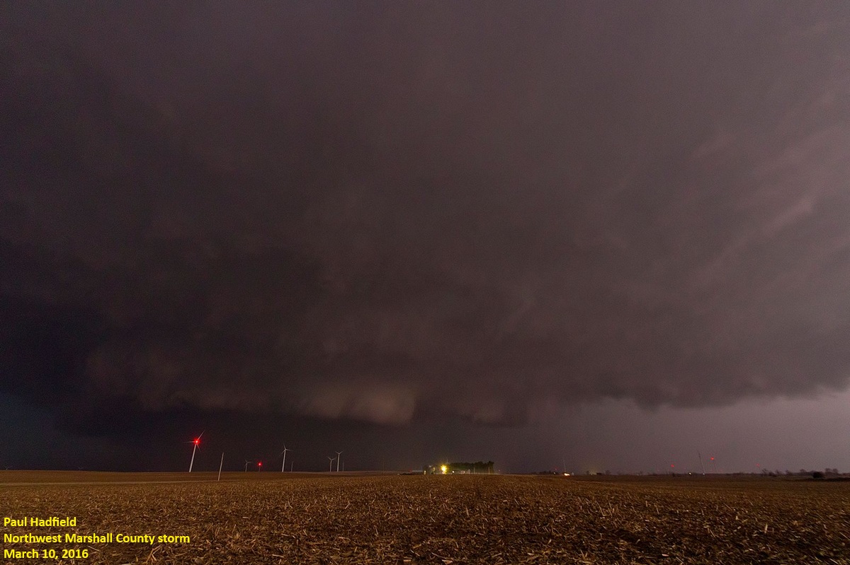
View of the NW Marshall Co storm (Source: SWOP Observer, Paul Hadfield) |
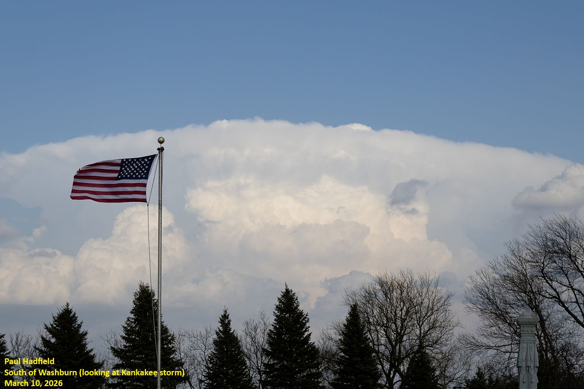
View of the Kanakakee tornadic supercell from S of Washburn (Source: SWOP Observer, Paul Hadfield) |
Additional Information
The Forecast
 |
 |
 |
 |
| SPC Day 3 Categorical Outlook | SPC Day 2 Categorial Outlook | 12Z SPC Day 1 Categorical Outlook | 16Z SPC Day 1 Categorial Outlook Upgraded to a Moderate Risk (Level 4 out of 5) |
 |
 |
 |
 |
| 16Z SPC Day 1 Tornado Outlook, showing a Level 2 Intensity over north-central IL | 16Z SPC Day 1 Wind Outlook | 16Z SPC Day 1 Hail Outlook | Tornado Watch issued around 4 PM on March 10, 2026 |
 |
 |
 |
|
| 6 PM surface analysis showing the warm front (red dashed) & a secondary wind shift (yellow highlighted) | 18Z Mar 10 KILX sounding | 00Z Mar 11 KILX Sounding |
Surrounding Office Event Summaries:
 |
Media use of NWS Web News Stories is encouraged! Please acknowledge the NWS as the source of any news information accessed from this site. |
|


