Overview
|
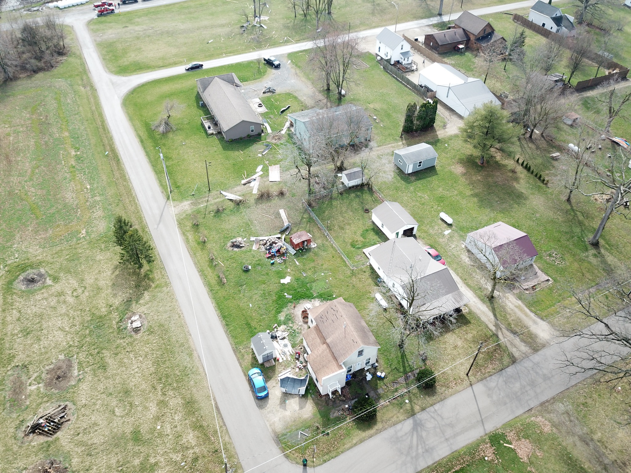
Several rounds of storms moved through the IWX county warning area on Thursday, March 14th. The first early morning round of sub-severe storms was mainly elevated along and north of a warm front with reports of locally heavy rainfall (1-2") and pea sized hail. There were several reports of water ponding in low-lying areas and on roads. A second linear segment (QLCS) followed through from an upstream convective complex in the mid morning through early afternoon hours. Most of this activity remained elevated with primarily sub-severe hail and heavy rainfall. There were a few severe wind damage reports within stronger storms near Bluffton, IN and Wren, OH. A new daily record rainfall was recorded at the Fort Wayne International Airport (KFWA) with a total of 2.12" The previous record was 0.94" set in 1994. Storm redevelopment by late afternoon led to several supercells and multicell clusters south of US 24, with large hail up to 2.5" and a few reports of wall clouds in Wells and Grant Counties. There was also some isolated wind damage reports in Putnam County, OH in Columbus Grove. An EF-1 tornado was confirmed in Adams County, IN that then crossed the Indiana/Ohio stateline (also the CWA border between our office and NWS Wilmington OH) into Mercer County, OH. All of the severe weather in the afternoon and early evening of March 14th was confined to south of the US 24 corridor. Just across our county warning area borders, in the NWS Indianapolis, NWS Wilmington OH, and NWS Cleveland areas, there were multiple reports of strong tornadoes and large hail. |
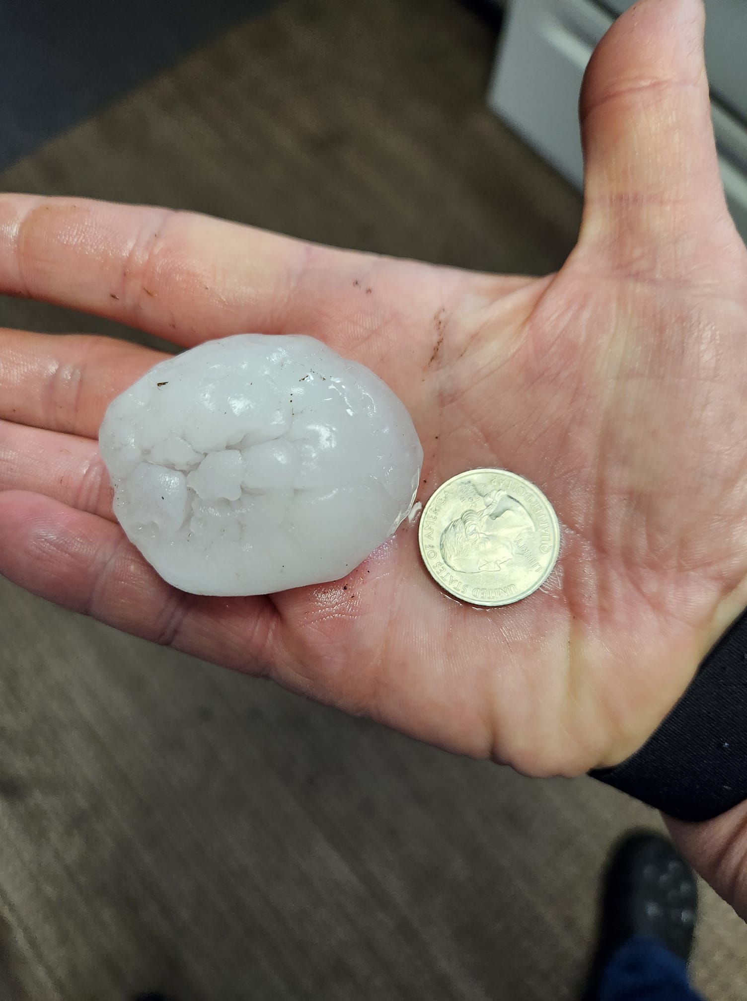
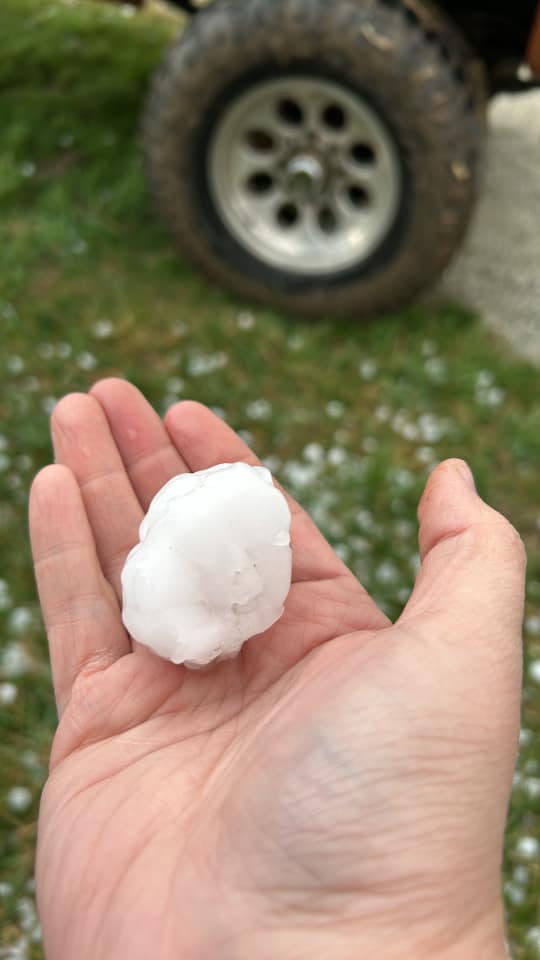
 Several hailstones that fell in Poneto, IN in Wells County. The largest of these hailstones was measured at 2.5 inches, which was the largest hailstone report we received during the event (Peg Mansfield) |
Tornado:
|
Tornado - New Corydon, Indiana to Celina, Ohio
Track Map 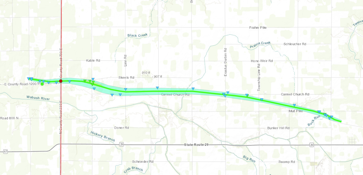 
Downloadable KMZ File |
||||||||||||||||
 |
 |
 |
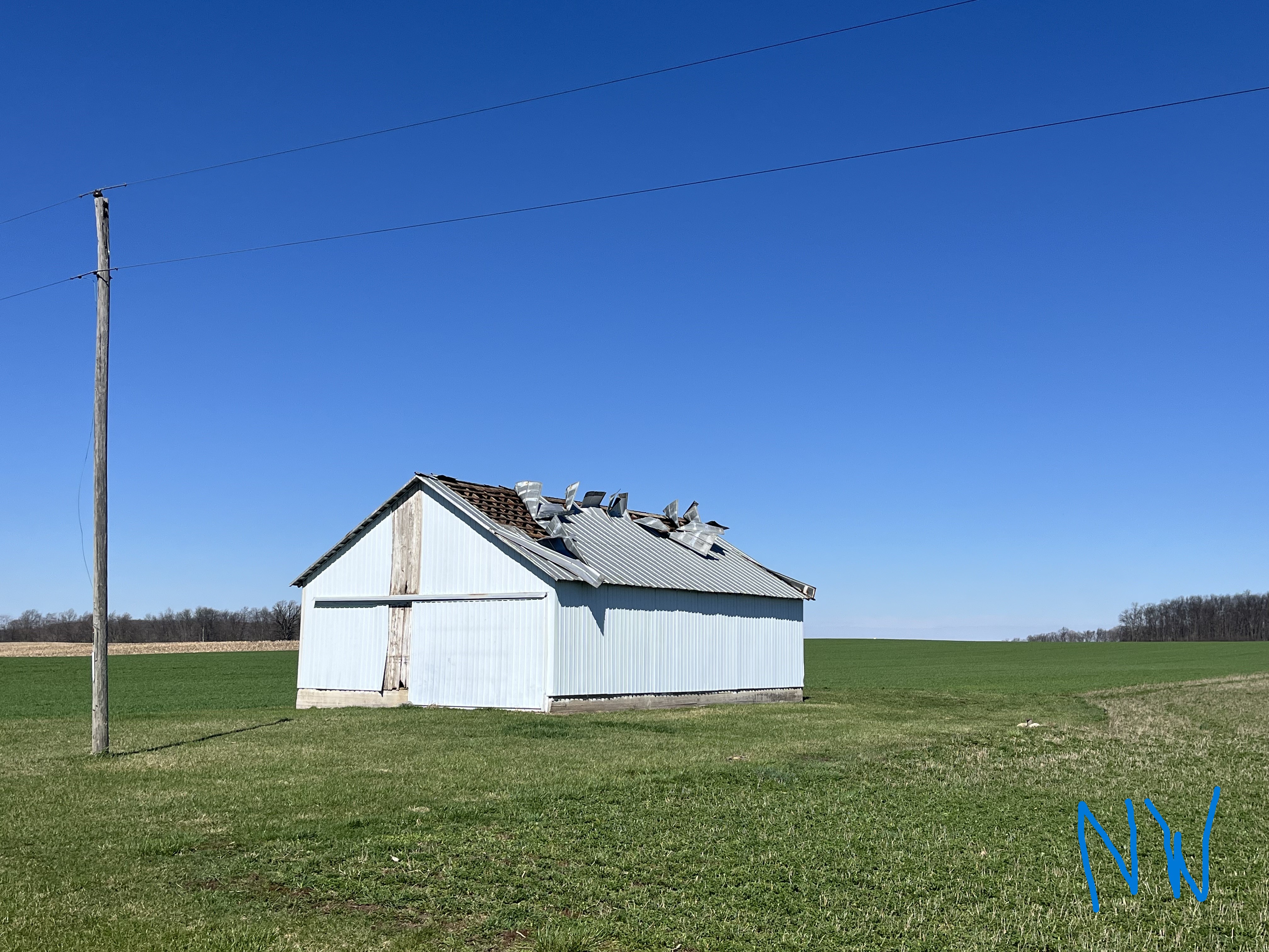 |
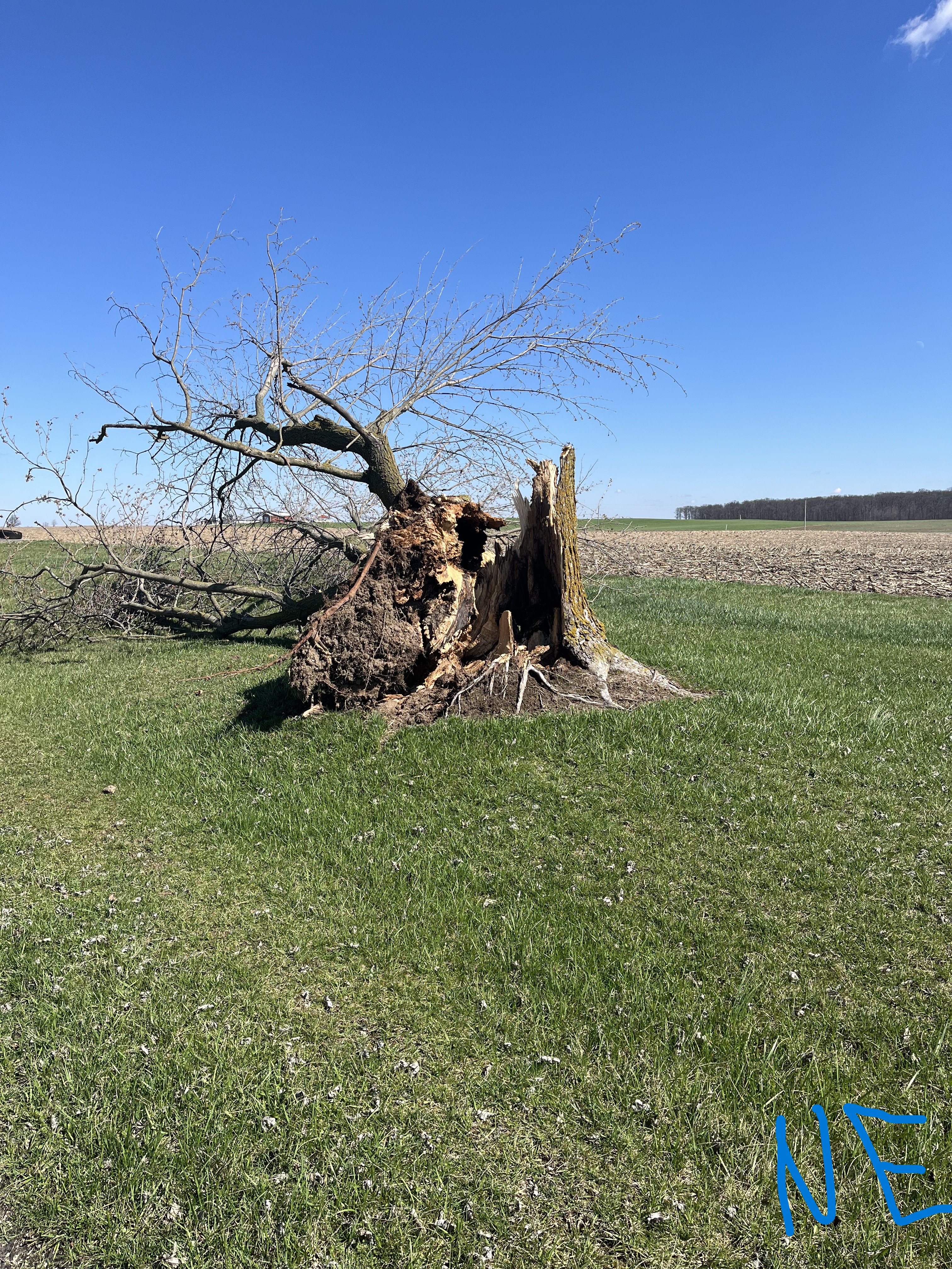
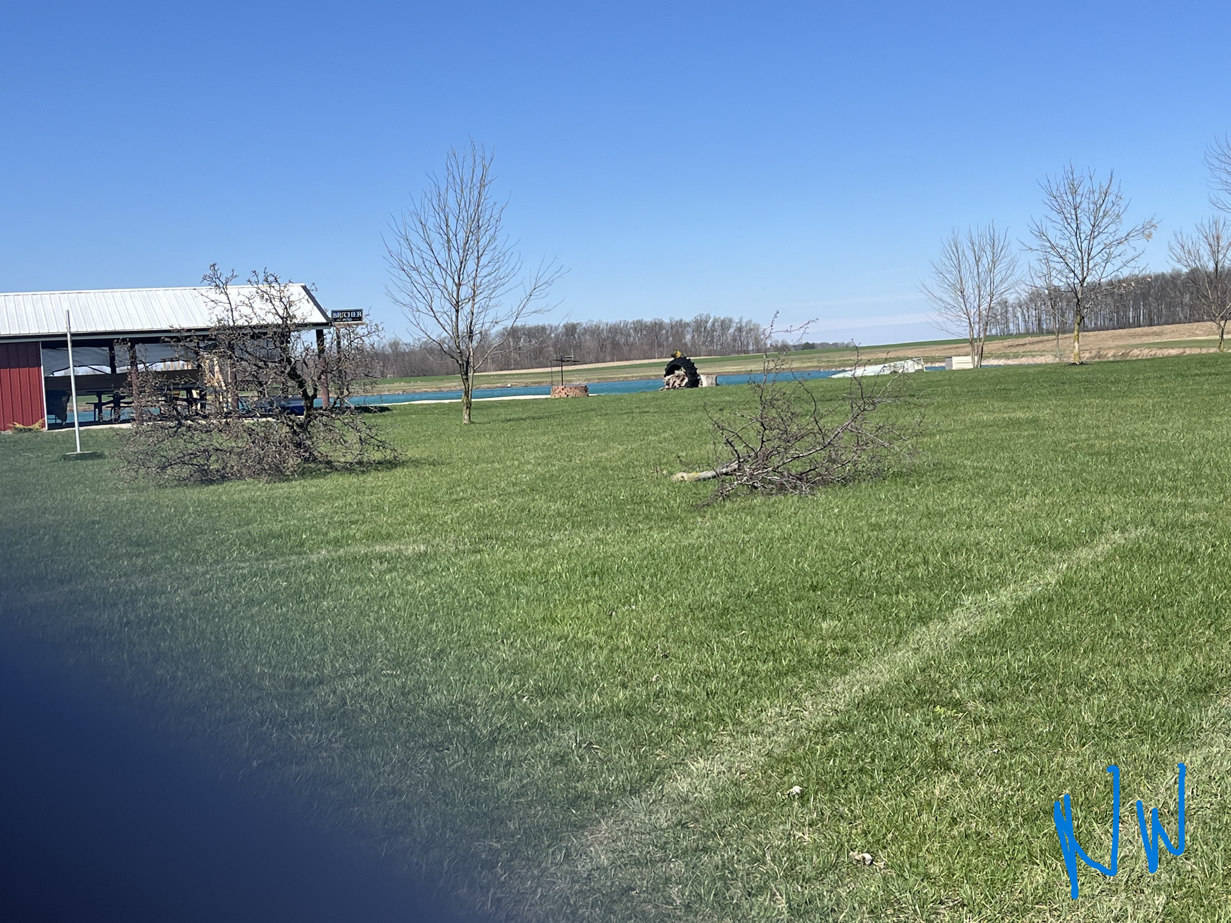
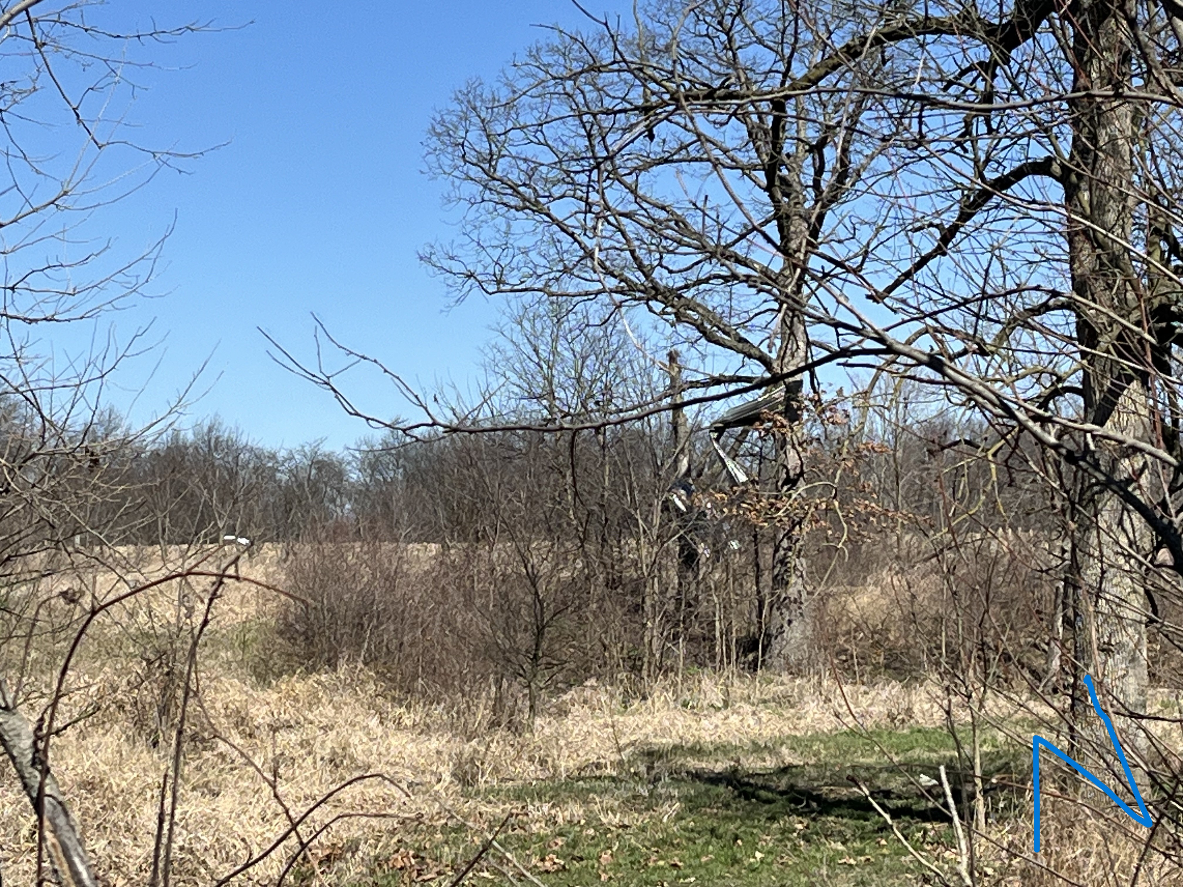
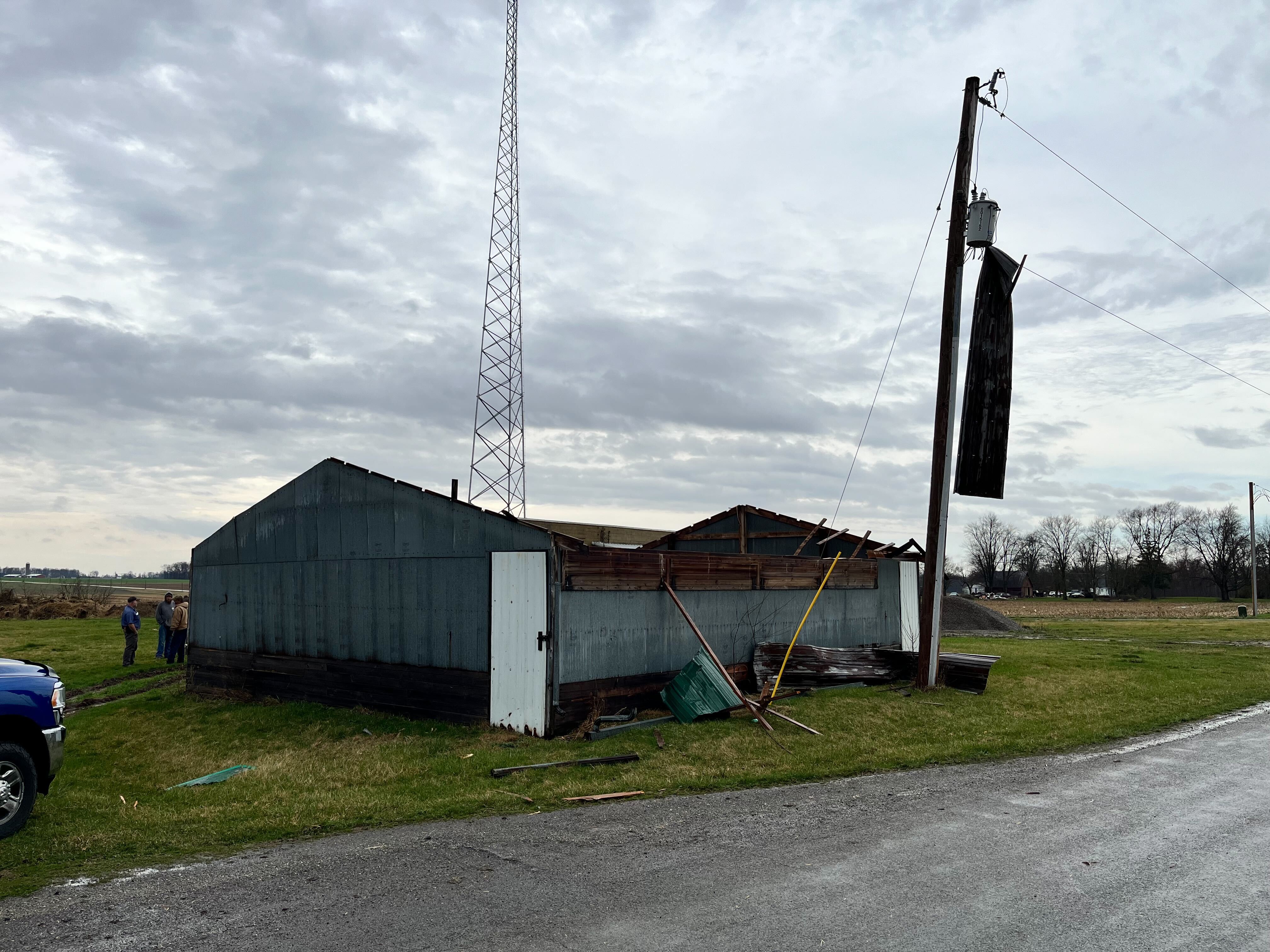
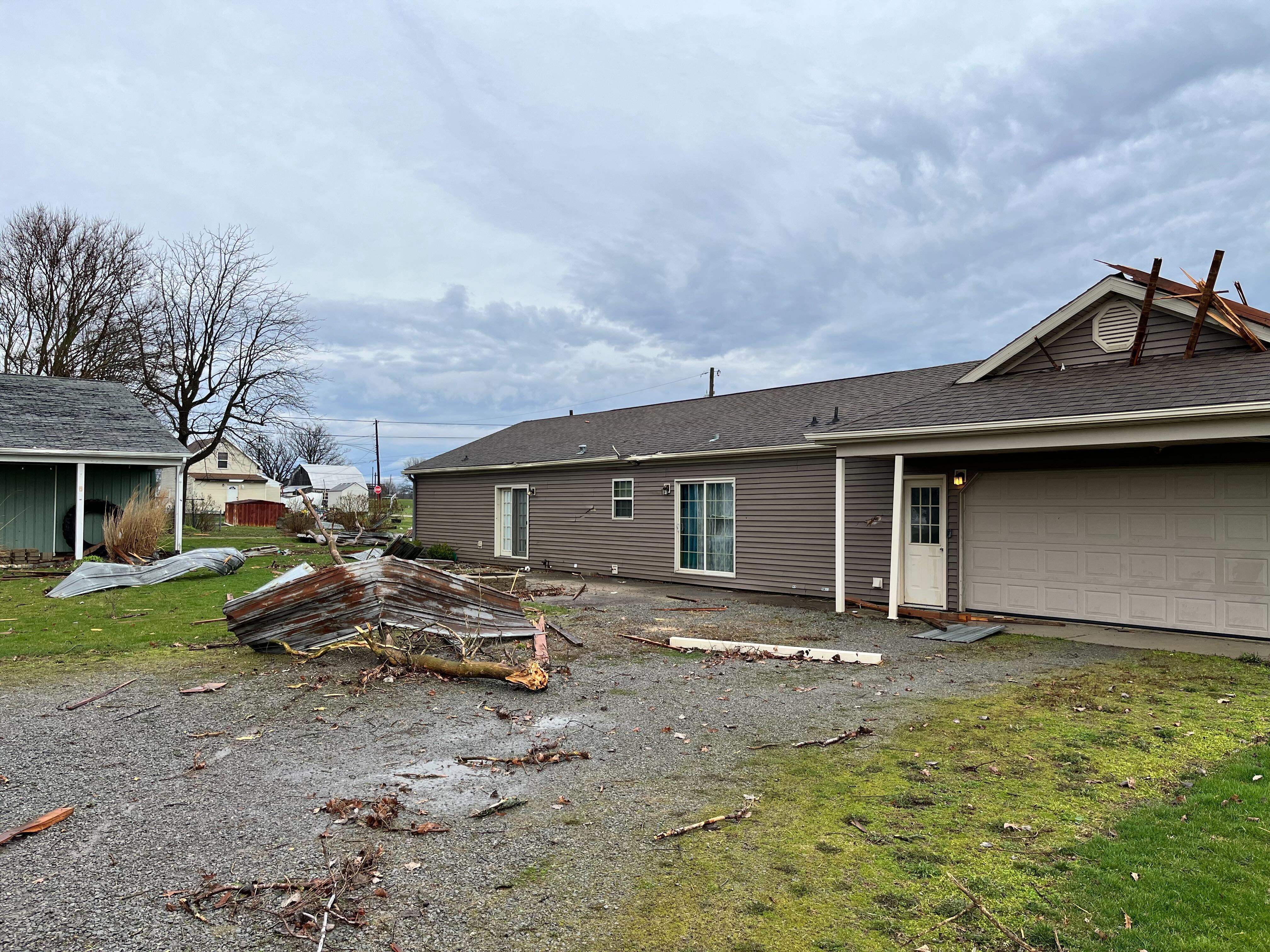
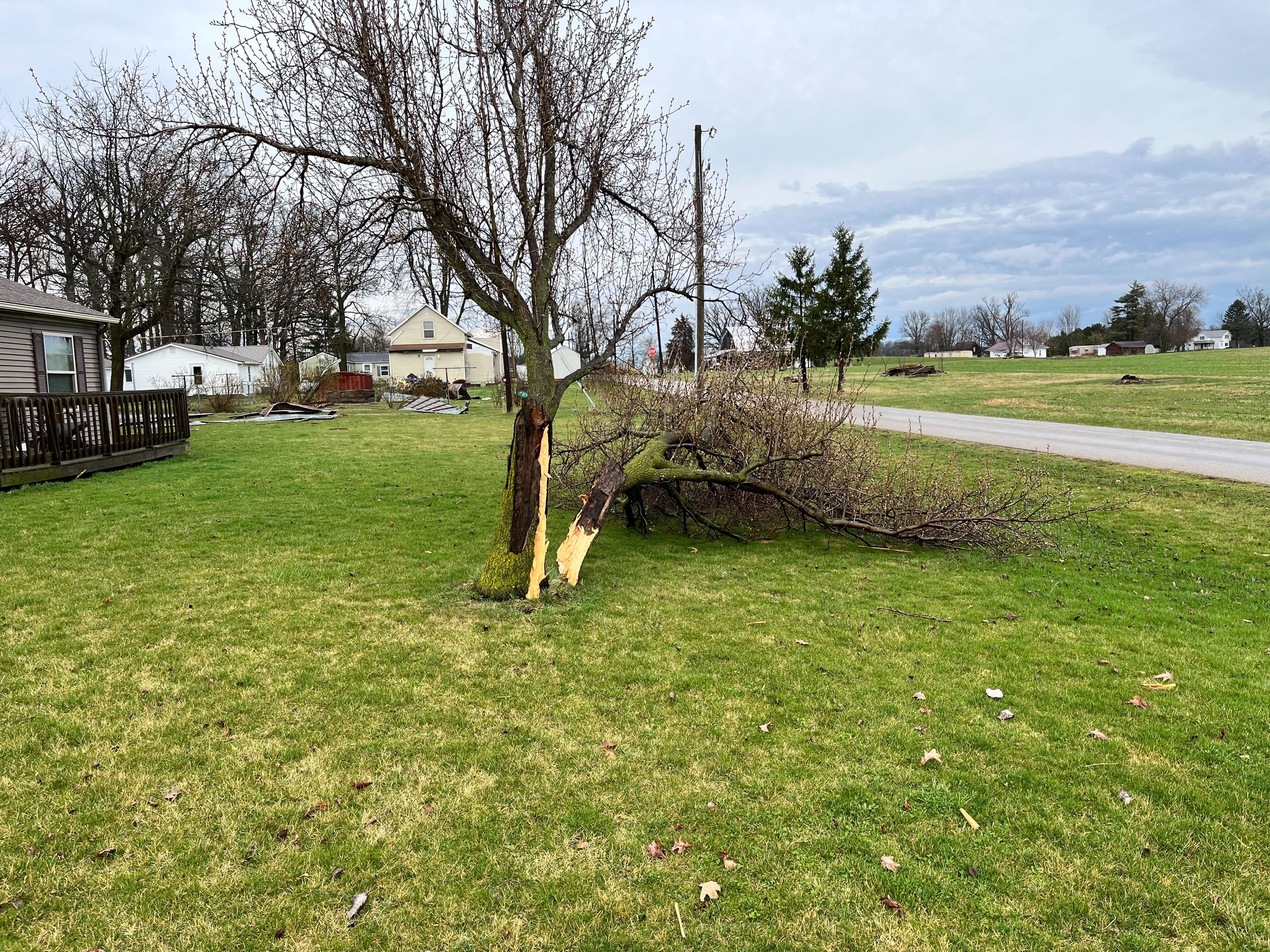
| A large tree (2+ ft in diameter) was snapped on E County Road 1200 S near the Indiana/Ohio stateline (Jay County EMA) | Several trees and large branches snapped on E County Road 1200 S near the Indiana/Ohio stateline (Jay County EMA) | Sheet metal was found twisted into a grove of trees just north of E County Road 200 S. (Jay County EMA) | Damage to sheet metal roof on the east facing side of an outbuilding. Building located on the Adams/Jay County line on E County Road 1200 S. (Jay County EMA) |
The Enhanced Fujita (EF) Scale classifies tornadoes into the following categories:
| EF0 Weak 65-85 mph |
EF1 Moderate 86-110 mph |
EF2 Significant 111-135 mph |
EF3 Severe 136-165 mph |
EF4 Extreme 166-200 mph |
EF5 Catastrophic 200+ mph |
 |
|||||
Wind and Hail Photos
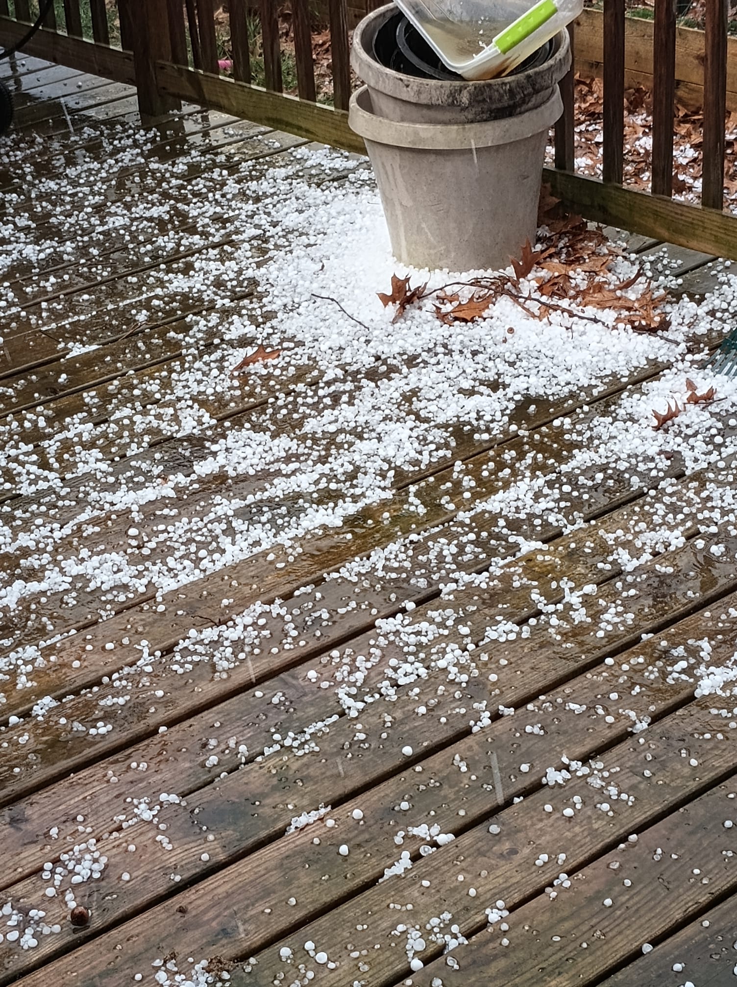
Significant 2"+ Hail in the northeast portion of north-central Indiana
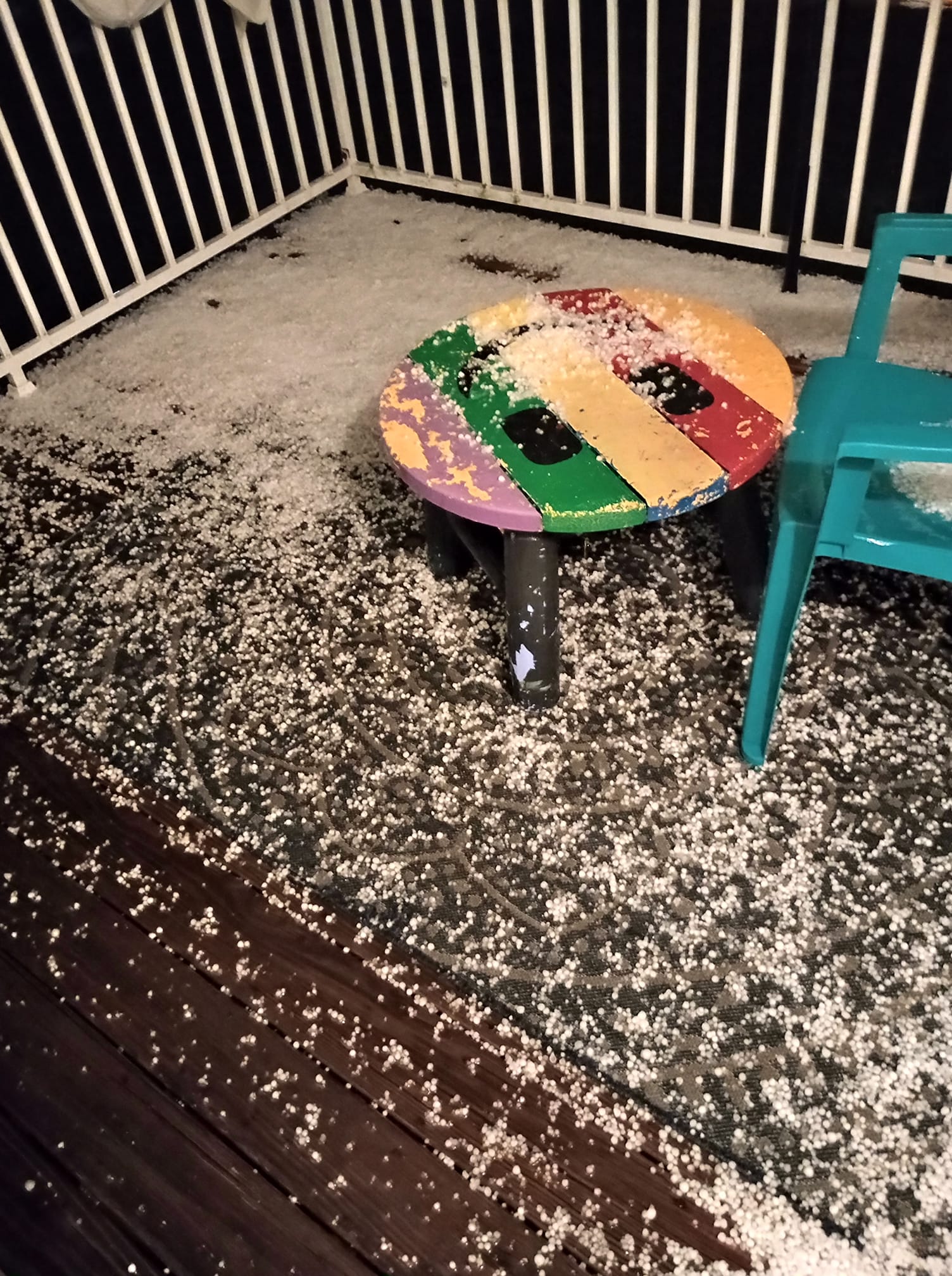
Isolated thunderstorm wind damage occurred in Bluffton, IN and Wren, OH during the midday round of storms. Another round of storms later in the afternoon and evening of March 14th yield large hail across the far southwest portion of our forecast area. The largest hailstones were observed in southern Wells County, IN, especially in and around Poneto, IN, where several 2" to 2.5" hailstones were observed and photographed.
 |
 |
 |
 |
| A 2 inch hailstone near Mount Zion, IN in Wells County (Matthew Hartman) | Several photos of hailstones up to 1" in diameter covering the ground in Bluffton, IN in Wells County. (Chuck Belanger) | A 2 inch hailstone in Poneto, IN in Wells County. (Cindy Johnson - relayed by Liz Braden WPTA) | Damage to a home in Poneto, IN in Wells County. A window was smashed and siding was damaged by 1-2" hailstones. (Rebeca Neely - relayed by Liz Braden WPTA) |
 |
 |
 |
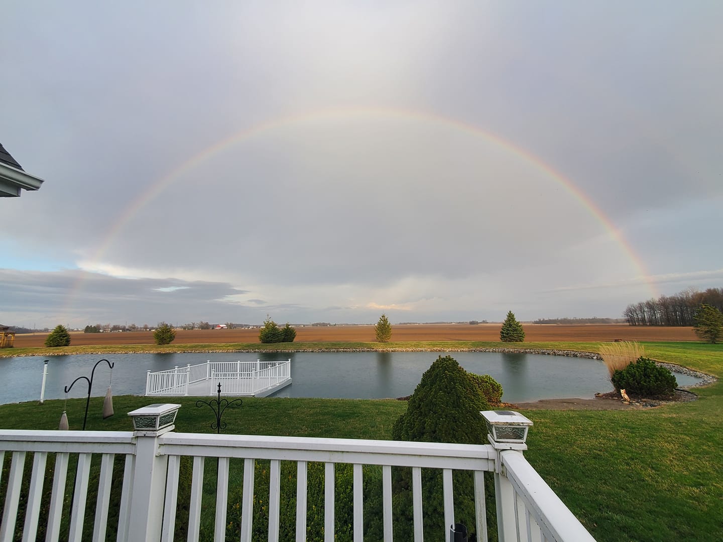 |
| A 2 inch hailstone near Poneto, IN in Wells County (Abigail Hardin Schoeff) | Small hailstones covering the ground in Wabash, IN in Wabash County. (Stephanie Page) | A hailstone much larger than a quarter in Poneto, IN in Wells County. We estimate this hailstone was 2"+ in diameter. (Drizzy Jagger) | A rainbow in Bluffton, IN after the storms moved through (Holly Johnson) |
.jpg) |
 |
 |
|
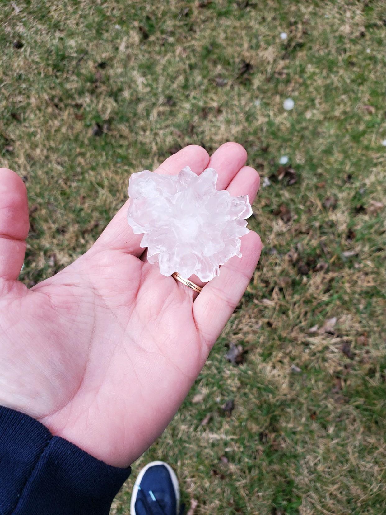
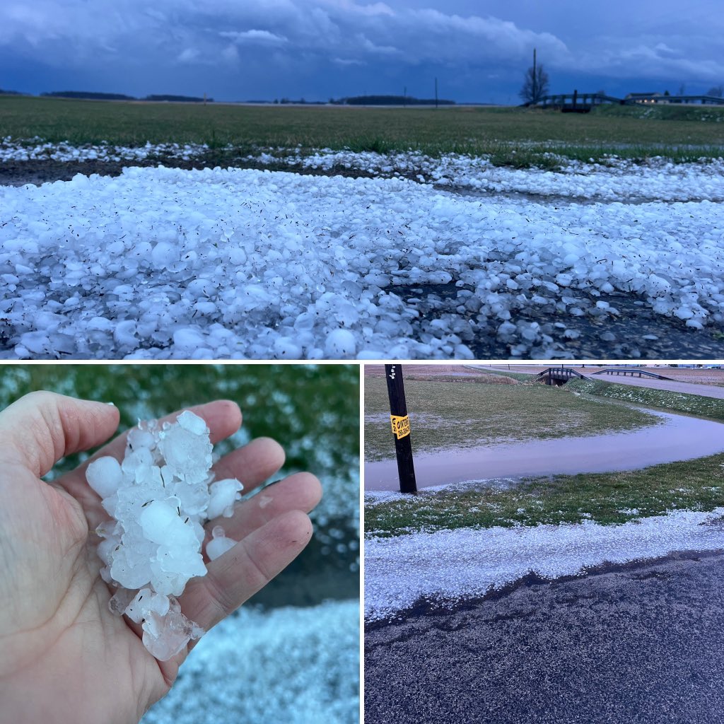
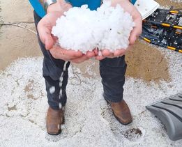
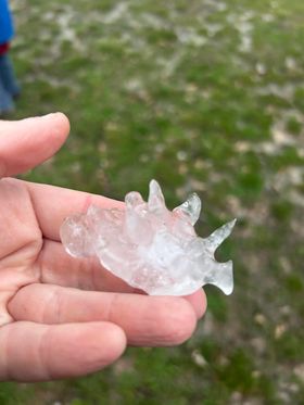
| Numerous hailstones covering the ground in Poneto, IN (Cindy Johnson - relayed by Liz Braden WPTA) | Handfuls of small hail were able to be scooped up in Marion, IN in Grant County after severe storms moved through the area. (Shelby Smith) | A large 2"+ diameter hailstone that fell between Poneto and Montpelier, IN near the Wells/Blackford County line. (Sheila Ruley) | Several 2 to 2.5" hailstones fell in Poneto, IN in Wells County. (Peg Mansfield) |
%20Poneto1%20hail%20damage.jpg) |
%20Poneto%20hail%20damage.jpg) |
 |
 |
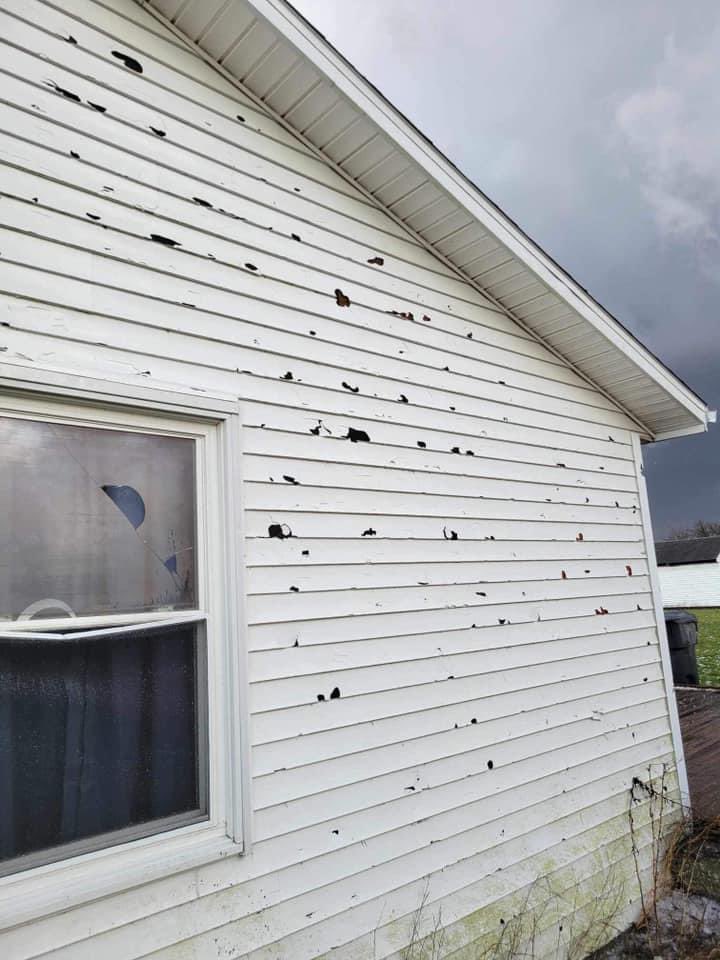
| Hail left holes in the ground in Poneto, IN. (Ralph and Connie Warner Johnson - relayed by Matthew Hartman) | Siding on a home in Poneto, IN was left damaged by hail. (Ralph and Connie Warner Johnson - relayed by Matthew Hartman) | Hail covered the ground in Huntington, IN after sub-severe storms moved through on the morning of March 14th. (Todd Huston) | 2" hailstones fell near the intersection of SR 1 and IN 218 in Wells County, causing damage to homes and cracking car windshields. (Jessie Jones) |
 |
 |
 |
 |
| Drone footage showing straightline wind damage to several homes in Wren, OH that occurred on the morning of March 14 (Van Wert County EMA) | Damage to a building in Wren, OH. Part of the building's metal roof is in the adjacent powerlines. (Van Wert County EMA) | Damage to a home in Wren, OH (Van Wert County EMA) | Straightline winds left trees and branches down in Wren, OH on the morning of March 14 (Van Wert County EMA) |
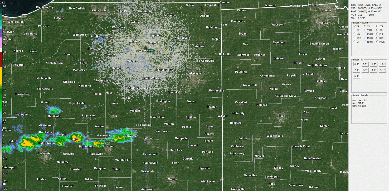
Radar
Here are radar loops and images of the severe storms that moved through the southwest portion of our forecast area in the late afternoon and early evening of March 24th. Storms stayed mainly along and south of the US 24 corridor.
 |
 |
 |
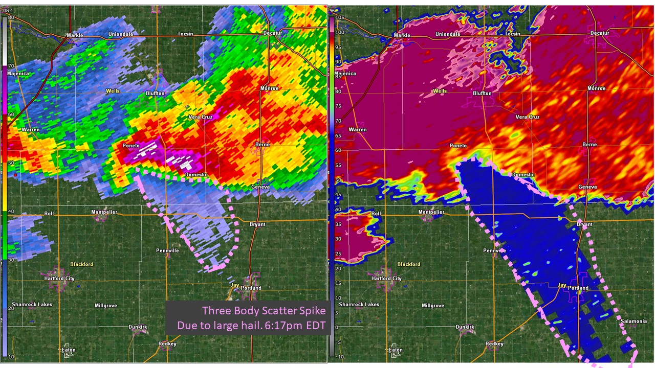 |
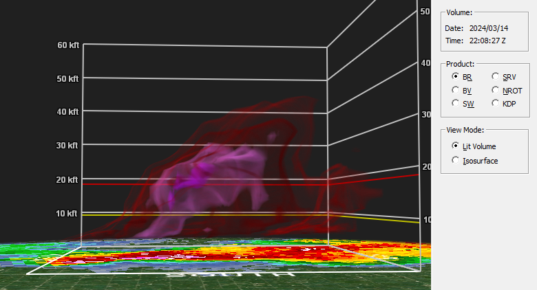
| Summary of radar and reports through the bulk of the severe weather from 4:45pm to 7:45pm ET. Via GR2Analyst | The strong storm near Poneta, IN in Wells county around 6:08pm ET lofted between 65 and 75 dBZ reflectivity to -20C before the core dropped its hail. Via GR2Analyst | Radar base reflectivity (left) and storm relative velocity (right) of the hail-producing storm over Poneto, IN. | Radar base reflectivity (left) and Correlation Coefficient (right). A Three Body Scatter Spike is outlined in pink. This occurs when a portion of the radar beam are forward-scattered to the ground and then back. This is a strong signal for large hail. |
Storm Reports & Rainfall Reports
223
NWUS53 KIWX 150029
LSRIWX

Preliminary Local Storm Report...Summary
National Weather Service Northern Indiana
829 PM EDT Thu Mar 14 2024

..TIME...   ...EVENT...      ...CITY LOCATION...     ...LAT.LON...
..DATE...   ....MAG....      ..COUNTY LOCATION..ST.. ...SOURCE....
            ..REMARKS..

1036 AM     Hail             1 WSW Monticello        40.74N 86.78W
03/14/2024  E0.75 inch       White              IN   Public

            Report from mPING: Dime (0.75 in.).

1240 PM     Tstm Wnd Dmg     1 N Bluffton            40.75N 85.17W
03/14/2024                   Wells              IN   Trained Spotter

            Damage to a power pole on SR-1 in Bluffton.

1258 PM     Tstm Wnd Dmg     Wren                    40.80N 84.78W
03/14/2024                   Van Wert           OH   Emergency Mngr

            Roof damage to a home in Wren.
0540 PM     Hail             Warren                  40.69N 85.43W
03/14/2024  E1.75 inch       Huntington         IN   Public
0542 PM     Hail             1 NW Jalapa             40.64N 85.76W
03/14/2024  M1.00 inch       Grant              IN   Trained Spotter


0550 PM     Hail             Santa Fe                40.65N 85.99W
03/14/2024  E1.50 inch       Miami              IN   Public


0604 PM     Hail             Decatur                 40.83N 84.93W
03/14/2024  M1.00 inch       Adams              IN   Amateur Radio


0604 PM     Hail             1 S Bluffton            40.73N 85.17W
03/14/2024  M1.00 inch       Wells              IN   Storm Chaser


0605 PM     Hail             Mount Zion              40.65N 85.33W
03/14/2024  M2.00 inch       Wells              IN   Public


0612 PM     Hail             Poneto                  40.65N 85.22W
03/14/2024  E2.00 inch       Wells              IN   Public

            Corrects time of previous hail report from
            Poneto.
0613 PM     Hail             Poneto                  40.66N 85.22W
03/14/2024  M2.50 inch       Wells              IN   Public

            Photo received on Facebook of a measured 2.5
            hailstone in Poneto. Time estimated by
            radar.

0615 PM     Hail             2 N Dillman             40.64N 85.25W
03/14/2024  M1.00 inch       Wells              IN   Trained Spotter

            Quarter size hail reported 2 SW of Poneto.
            Time estimated from radar.

0618 PM     Hail             2 N Dillman             40.64N 85.25W
03/14/2024  M1.50 inch       Wells              IN   Storm Chaser


0618 PM     Hail             1 N Wellsburg           40.68N 85.22W
03/14/2024  E1.00 inch       Wells              IN   Public

            Report from mPING: Quarter (1.00 in.).

0625 PM     Hail             2 N Wells               40.75N 86.11W
03/14/2024  M1.50 inch       Miami              IN   Emergency Mngr


0627 PM     Hail             Berne                   40.66N 84.95W
03/14/2024  M1.00 inch       Adams              IN   Public

            Quarter size hail photo on Twitter. Time
            estimated from radar.

0640 PM     Hail             1 N Fiat                40.56N 85.15W
03/14/2024  E1.50 inch       Jay                IN   Public


0649 PM     Hail             Ottoville               40.93N 84.34W
03/14/2024  M1.00 inch       Putnam             OH   Emergency Mngr


0704 PM     Hail             1 SSE Marion            40.54N 85.66W
03/14/2024  M1.00 inch       Grant              IN   Trained Spotter


0718 PM     Tstm Wnd Dmg     Columbus Grove          40.92N 84.06W
03/14/2024                   Putnam             OH   Emergency Mngr

            Semi blown over and several road signs
            downed.

0730 PM     Hail             2 W Trenton             40.45N 85.28W
03/14/2024  M1.00 inch       Blackford          IN   Storm Chaser
0735 PM     Hail             Center                  40.45N 85.08W
03/14/2024  E1.25 inch       Jay                IN   Public
629
NOUS43 KIWX 141850
PNSIWX
INZ005>009-012>015-017-018-020-022>027-032>034-103-104-116-203-204-216-MIZ078>081-
177-277-OHZ001-002-004-005-015-016-024-025-150650-

Public Information Statement
National Weather Service Northern Indiana
250 PM EDT Thu Mar 14 2024

...24 HOUR RAINFALL REPORTS AS OF 250 PM EDT...

Location                     Amount    Time/Date       Provider

...Indiana...

...Allen County...
Fort Wayne International Ap  2.11 in   0154 PM 03/14   ASOS
SPENCERVILLE                 1.46 in   0230 PM 03/14   CWOP
Fort Wayne 7.6 SE            0.92 in   0700 AM 03/14   COCORAHS
Monroeville 0.2 ESE          0.88 in   0700 AM 03/14   COCORAHS
Fort Wayne 9.1 SE            0.88 in   0700 AM 03/14   COCORAHS
Harlan 2.2 ENE               0.84 in   0700 AM 03/14   COCORAHS
Hoagland 1.5 SSW             0.76 in   0700 AM 03/14   COCORAHS

...Cass County...
Walton                       0.83 in   0230 PM 03/14   CWOP

...Elkhart County...
Jamestown                    1.62 in   0238 PM 03/14   CWOP
Goshen                       1.12 in   0238 PM 03/14   ASOS
Elkhart Municipa             0.85 in   0235 PM 03/14   AWOS

...Fulton County...
Rochester                    1.31 in   0235 PM 03/14   AWOS
Rochester 2.4 NW             1.02 in   0700 AM 03/14   COCORAHS

...Huntington County...
1.7 E Bowerstown             2.76 in   0200 PM 03/14   HADS
Huntington 0.3 W             1.58 in   0700 AM 03/14   COCORAHS
Huntington                   0.93 in   0238 PM 03/14   CWOP
2.4 NW Warren                0.83 in   0145 PM 03/14   HADS

...Kosciusko County...
1 SW Sevastopol              2.29 in   0244 PM 03/14   AWS
1 NE Beaver Dam Lake         2.25 in   0913 AM 03/14   Mesonet
Winona Lake 0.9 SW           1.37 in   0630 AM 03/14   COCORAHS
Warsaw Muni                  1.24 in   0235 PM 03/14   AWOS
1 SSE Clunette               1.22 in   0240 PM 03/14   AWS
Warsaw 3.0 SE                1.12 in   0730 AM 03/14   COCORAHS
Warsaw 3.7 E                 0.95 in   0730 AM 03/14   COCORAHS
Leesburg 0.1 WNW             0.94 in   0730 AM 03/14   COCORAHS

...La Porte County...
New Carlisle 3.0 WNW         1.10 in   0900 AM 03/14   COCORAHS
La Porte                     1.05 in   0235 PM 03/14   AWOS
La Crosse 1.2 W              0.80 in   0800 AM 03/14   COCORAHS
La Porte 2.3 ESE             0.76 in   0930 AM 03/14   COCORAHS

...Marshall County...
Tippecanoe 0.8 S             1.18 in   0700 AM 03/14   COCORAHS

...Miami County...
Peru                         1.46 in   0230 PM 03/14   HADS
Grissom AFB Peru             0.88 in   0235 PM 03/14   AWOS

...Pulaski County...
1.3 SW Ora                   2.06 in   0145 PM 03/14   COOP
Monterey 1.3 WNW             1.41 in   0800 AM 03/14   COCORAHS
Monterey 2.2 WNW             1.32 in   0800 AM 03/14   COCORAHS

...St. Joseph County...
South Bend                   2.00 in   1258 PM 03/14   Trained Spotter
0.9 W Roseland               1.50 in   0215 PM 03/14   COOP
South Bend International Ap  1.44 in   0224 PM 03/14   ASOS
Walkerton 4.1 ENE            0.92 in   0930 AM 03/14   COCORAHS
Lakeville 1.5 SSW            0.80 in   0853 AM 03/14   COCORAHS

...Starke County...
3.5 N Brems                  1.71 in   0200 PM 03/14   HADS

...Steuben County...
0.7 E Hamilton               1.36 in   0145 PM 03/14   HADS

...Wabash County...
0.7 SE Wabash                1.16 in   0230 PM 03/14   HADS

...Wells County...
Bluffton                     0.90 in   0145 PM 03/14   HADS

...Michigan...

...Berrien County...
Niles                        0.82 in   0237 PM 03/14   CWOP

...Branch County...
1 SSW Coldwater              0.94 in   0242 PM 03/14   AWS
QUINCY                       0.93 in   0240 PM 03/14   CWOP

...St. Joseph County...
2.0 SE Mendon                0.85 in   0200 PM 03/14   UCOOP
Sturgis Kirsch               0.79 in   0235 PM 03/14   AWOS

...Ohio...

...Defiance County...
Defiance                     0.96 in   0211 PM 03/14   ASOS

...Paulding County...
Paulding 5.6 ESE             0.78 in   0700 AM 03/14   COCORAHS

...Van Wert County...
1 WNW Convoy                 1.46 in   0240 PM 03/14   AWS
Van Wert                     0.83 in   0236 PM 03/14   CWOP
Van Wert                     0.77 in   0240 PM 03/14   CWOP

...Williams County...
3 S Nettle Lake              1.43 in   0240 PM 03/14   AWS

...HAIL REPORTS...

Location                     Size      Time/Date       Provider

...Indiana...

...Noble County...
4 WSW Lisbon                 1.00 in   1141 AM 03/14
Environment
Synoptic and mesoscale parameters indicated a favorable environment for large hail (2"+) and tornadoes
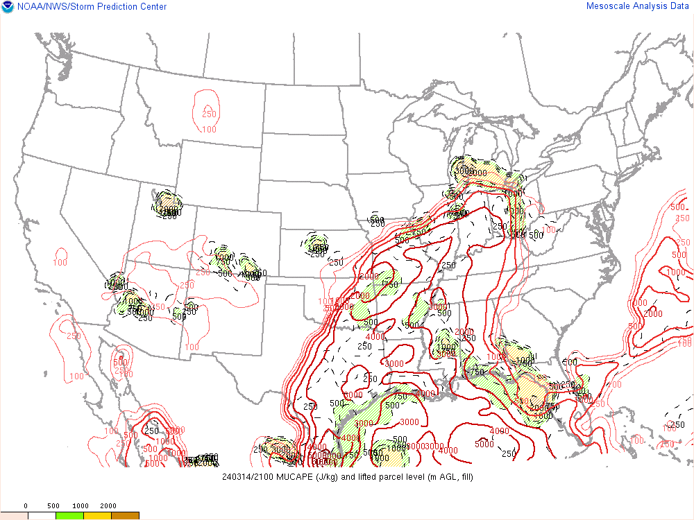
In the morning and early afternoon of March 14th, MUCAPE was into the 500-1000 j/kg range into areas mainly along/south of US 30 with stable near surface conditions north of the surface warm front. Deep layer shear in excess of 50 kts and decent mid level lapse rates aided in producing some more intense cores with pea to nickel size hail reported. The 1630Z and 20Z Day 1 Outlooks from the NWS Storm Prediction Center (SPC) maintained a Slight Risk (level 2 of 5) across the southern half of the CWA (south of US 30) in anticipation of storm redevelopment in the late afternoon/evening of March 14th.
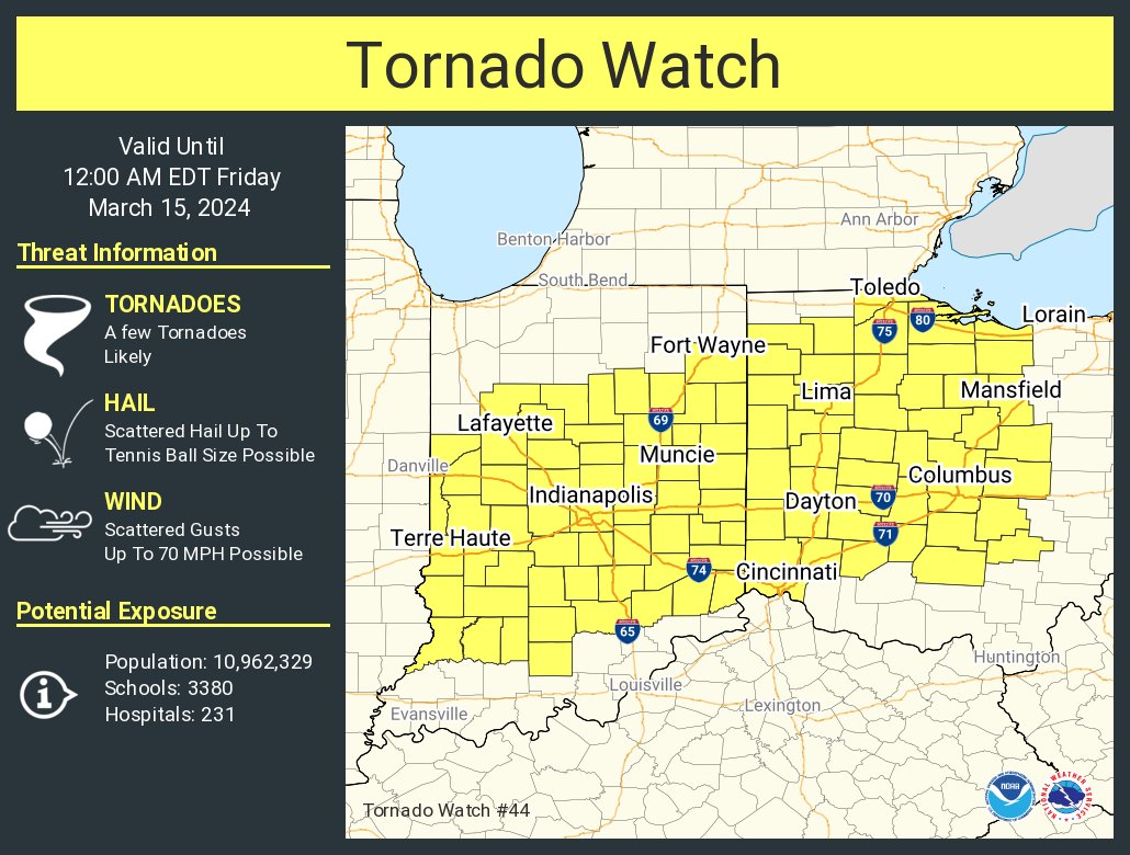
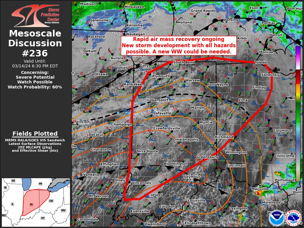
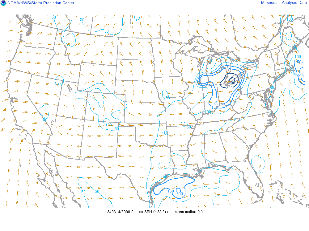
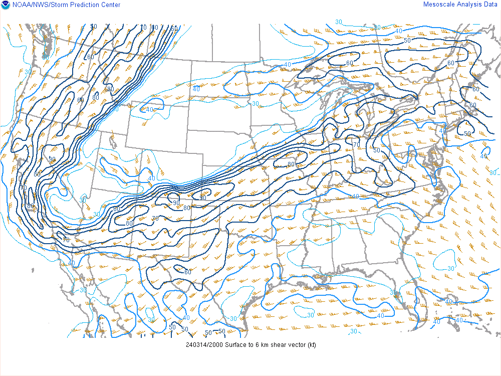
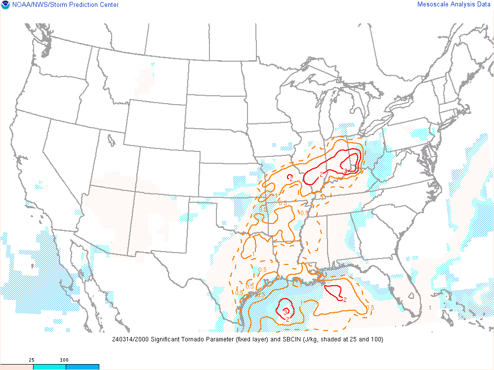
By late afternoon (around 20-21Z), there were favorable mesoscale parameters in place for large hail (up to 2") and an isolated tornado or two. Favorable mesoscale parameters for tornadoes included, 60-70 kts of 0-6 km shear, 20-30 kts of 0-1 km shear, STP values of 0.5 to 1 (especially in Grant, Blackford, and Jay counties), MLCAPE of up to 1000 J/kg, LCL heights were between 750-1000 meters, and 0-1 km SRH between 50-100 m2/s2. The SRH was the only mesoscale parameter that was determined to be lacking before and during the event, as preferred SRH values should be closer to 150 m2/s2. We did have several reports of wall clouds within the severe storms that moved through Wells and Grant Counties. Several of the aforementioned mesoscale parameters met the necessary values but weren't as high as they could have been. As for large hail, many of the mesoscale parameters indicated large hail up to 2" would be the primary threat on the evening of March 14th. This includes MUCAPE between 1000 to 1750 J/kg, 60-70 kts of 0-6 km shear, mid level lapse rates of 6.5-7 C/km (occasionally up to 8C/km after 20Z), and a significant hail parameter (SHIP) of 1.5 to 2. A Tornado Watch was issued at 515 PM EDT. Many of these parameters met the criteria for 2". Ultimately, hail up to 2.5" did verify, with many hailstones in the Poneto, IN (Wells County) area measuring between 1-2" (a few hailstones were 2.5") around 6:15-6:30 PM EDT on March 14, 2024.
 |
 |
 |
| Figure 1: Tornado Watch #44 was issued by the NWS SPC at 515 PM EDT. Hazards included a few tornadoes, scattered tennis ball sized hail (2.5"), and scattered wind gusts up to 70 MPH. | Figure 2: Mesoscale Discussion #236 was issued by the NWS SPC at 438 PM EDT. The watch probability was 60% as the threat for severe storms was increasing by the afternoon hours. | Figure 3: The 20Z NWS SPC Day 1 Outlook had a Slight Risk (level 2 of 5) across much of our forecast area. The Slight Risk extended along and south of US 30. |
 |
 |
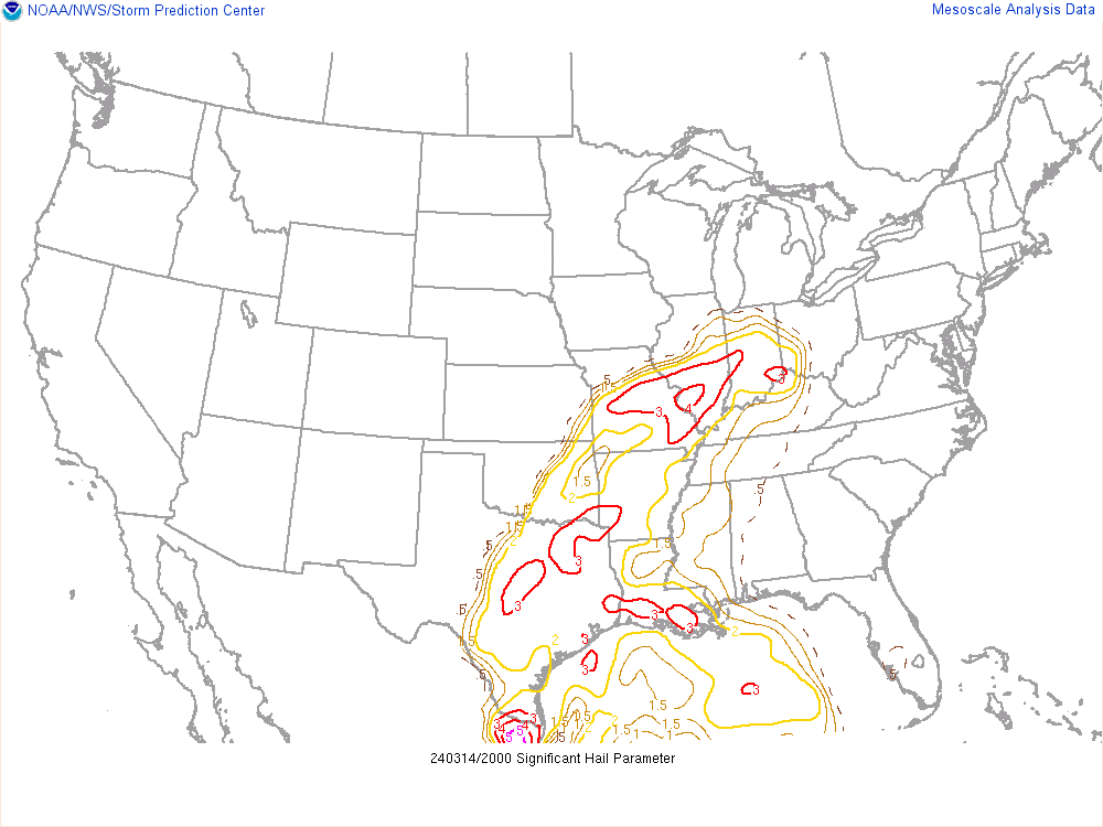 |
| Figure 4: 20Z 0-1 km SRH | Figure 5: 20Z 0-6 km shear | Figure 6: 20Z Significant Hail Parameter |
 |
 |
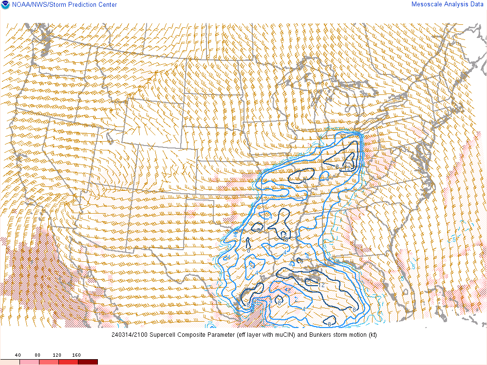 |
| Figure 7: 20Z Significant Tornado Parameter | Figure 8: 21Z MUCAPE | Figure 9: 21Z Supercell Composite Parameter |
 |
Media use of NWS Web News Stories is encouraged! Please acknowledge the NWS as the source of any news information accessed from this site. |
|

