
A prolonged atmospheric river will continue to impact the Pacific Northwest into the Northern Rockies with heavy rainfall, areas of urban and river flooding, landslides, heavy mountain snow, and gusty winds into Thursday. A strong clipper system will bring the threat of heavy snow and high winds across the Upper Midwest/Great Lakes as well as portions of the interior Northeast and Appalachians. Read More >
Northern Indiana
Weather Forecast Office
Welcome to the NWS Northern Indiana (IWX) COOP Page
What is the Cooperative Observing Program?


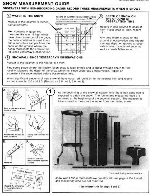
FPR-D Rain Gage instructions 8-inch Standard Rain Gage (SRG) MMTS temperature sensor

Additional Snow Measuring Videos

IV-ROCS version 2 additional instructions
IV-ROCS version 2 -- Missing Days Feature flow chart
NWS Cooperative Observer Newsletter
Hazards
Heat Related
Winter Related
Watch/Warning
Outlook
Storm Reports
Storm Prediction Center
Submit a Report
Event Ready
Climate
CoCoRaHS
FWA Daily
SBN Daily
FWA Monthly
SBN Monthly
Cliplot
Spring Frost Climatology
Fall Frost Climatology
Severe Climatology
Tornado Climatology
Local Information
Public Information Statement
Probabilistic Snowfall
Storm Data
Skywarn
COOP
Our Office
WSR-88D
Headline Criteria
NOAA Weather Radio
Weather History
Social Media Feeds
Weather Events Page
US Dept of Commerce
National Oceanic and Atmospheric Administration
National Weather Service
Northern Indiana
7506 E 850 N
Syracuse, IN 46567
574-834-1104
Comments? Questions? Please Contact Us.

