Overview
A potent upper level system allowed showers and isolated thunderstorms to form along a cold front. These showers progressed from northwest Indiana Sunday morning to northwest Ohio by mid afternoon. Several reports of wind damage wind wind gusts in excess of 60 mph were reported as these showers and isolated thunderstorms reached the Interstate 69 corridor across northeast Indiana and northwest Ohio. A thunderstorm wind gust of 77 mph was reported at the Fort Wayne International Airport.
Wind & Hail:
As the line of showers and isolated thunderstorms tracked eastward Sunday afternoon, reports of high wind gusts and wind damage were received across northeast Indiana including the Fort Wayne area and also across portions of northwest Ohio. A few reports of small hail were also received.
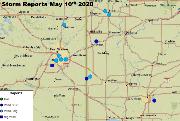 |
| Storm Reports from May 10th 2020 (Courtesy of SPC Storm Reports page) |
Storm Reports
PRELIMINARY LOCAL STORM REPORT...SUMMARY
NATIONAL WEATHER SERVICE NORTHERN INDIANA
843 PM EDT SUN MAY 10 2020

..TIME...   ...EVENT...      ...CITY LOCATION...     ...LAT.LON...
..DATE...   ....MAG....      ..COUNTY LOCATION..ST.. ...SOURCE....
            ..REMARKS..

1226 PM     TSTM WND GST     3 E CHAIN-O-LAKES       41.71N 86.32W
05/10/2020  M43 MPH          ST. JOSEPH         IN   ASOS


1226 PM     TSTM WND GST     GRISSOM AFB             40.66N 86.15W
05/10/2020  M47 MPH          MIAMI              IN   ASOS


1251 PM     HAIL             1 SW GOSHEN             41.57N 85.85W
05/10/2020  E0.25 INCH       ELKHART            IN   COCORAHS

            PEA SIZE HAIL FELL FOR 1 MINUTE.

1252 PM     TSTM WND GST     2 WSW SIMONTON LAKE     41.73N 86.00W
05/10/2020  M41 MPH          ELKHART            IN   AWOS


1253 PM     TSTM WND GST     1 N ELKHART             41.70N 85.97W
05/10/2020  E45 MPH          ELKHART            IN   PUBLIC

            SMALL BRANCHES DOWN, PEA-SIZED HAIL ALSO.

1255 PM     TSTM WND GST     2 ESE MONOQUET          41.27N 85.83W
05/10/2020  M41 MPH          KOSCIUSKO          IN   AWOS

            OBSERVATION AT THE WARSAW MUNICIPAL AIRPORT.

1256 PM     TSTM WND GST     2 NW BENTON             41.52N 85.79W
05/10/2020  M45 MPH          ELKHART            IN   ASOS

            45 MPH WIND GUST MEASURED AT GOSHEN AIRPORT.

0127 PM     HAIL             1 W COLUMBIA CITY       41.16N 85.50W
05/10/2020  E0.25 INCH       WHITLEY            IN   PUBLIC


0137 PM     TSTM WND GST     3 NNE NINE MILE         41.01N 85.20W
05/10/2020  M77 MPH          ALLEN              IN   ASOS

            CORRECTS PREVIOUS REPORT OF THE ASOS
            OBSERVATION AT THE FORT WAYNE AIRPORT.

0140 PM     TSTM WND DMG     2 E FORT WAYNE          41.07N 85.10W
05/10/2020                   ALLEN              IN   PUBLIC

            WIRES DOWNED, TREES INTO HOSES. PRIMARILY
            EAST SIDE OF FORT WAYNE INTO NEW HAVEN.

0140 PM     TSTM WND DMG     1 SW NEW HAVEN          41.06N 85.05W
05/10/2020                   ALLEN              IN   EMERGENCY MNGR

            2 POWER POLES SNAPPED.

0150 PM     TSTM WND DMG     2 NNE FORT WAYNE        41.10N 85.12W
05/10/2020                   ALLEN              IN   EMERGENCY MNGR

            LARGE TREE DOWN.

0210 PM     TSTM WND DMG     1 S FORT WAYNE          41.05N 85.14W
05/10/2020                   ALLEN              IN   AMATEUR RADIO

            15-20 FOOT TREE DOWNED AT ARCADIA CT. AND
            HOAGLAND AVE. TREE PARTIALLY BLOCKING
            ARCARDIA CT.

0213 PM     TSTM WND DMG     AUBURN                  41.37N 85.06W
05/10/2020                   DE KALB            IN   911 CALL CENTER

            DELAYED REPORT OF A TREE DOWNED ON A GARAGE
            ON 9TH STREET IN AUBURN, IN. NO INFORMATION
            ON THE SIZE OR HEALTH OF THE TREE. NO
            INJURIES REPORTED.

0229 PM     TSTM WND GST     4 NE ANTWERP            41.22N 84.69W
05/10/2020  M61 MPH          PAULDING           OH   MESONET


0230 PM     TSTM WND GST     5 NW MIDDLEBURY         40.90N 84.80W
05/10/2020  E60 MPH          VAN WERT           OH   EMERGENCY MNGR

            REPORT RELAYED BY THE EMERGENCY MANAGER,
            TIME ESTIMATED BY RADAR.

0233 PM     TSTM WND DMG     3 W CONVOY              40.92N 84.76W
05/10/2020                   VAN WERT           OH   EMERGENCY MNGR

            TWO MAPLE TREES 2 1/2 FEET IN DIAMETER
            UPROOTED. SHINGLES OFF NEARBY ROOFS. TIME
            ESTIMATED BY RADAR.

0245 PM     TSTM WND GST     3 NW BRUNERSBURG        41.34N 84.43W
05/10/2020  M47 MPH          DEFIANCE           OH   ASOS


0249 PM     TSTM WND DMG     3 WNW BRYAN             41.48N 84.59W
05/10/2020                   WILLIAMS           OH   EMERGENCY MNGR

            WITNESSED A LARGE TREE GO DOWN DURING THE
            STORM. ESTIMATED THE DIAMETER OF THE TREE
            WAS ABOUT 2 TO 2.5 FT, BUT THE HEALTH OF THE
            TREE IS UNKNOWN.

0302 PM     TSTM WND GST     3 NE YODER              40.71N 84.03W
05/10/2020  M60 MPH          ALLEN              OH   ASOS


&&

$$
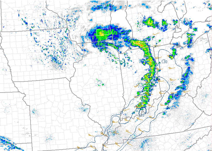
Radar
.5_ref_vel_1737.png) |
| Radar Reflectivity/Velocity 1:37 PM EDT 5/10/20 |
Environment
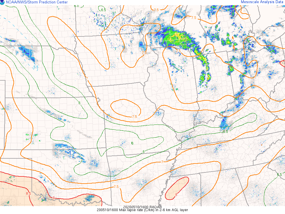
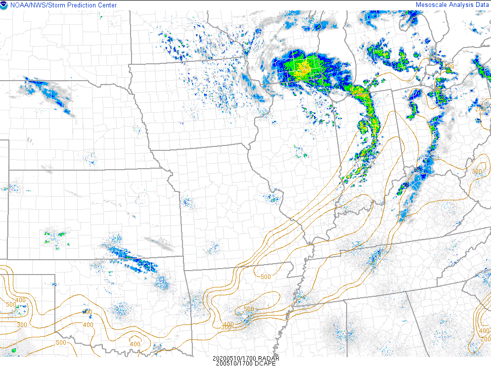
A vigorous upper level trough approached the southern Great Lakes and Ohio Valley on Sunday afternoon providing strong forcing. The low level air mass was quite dry ahead of an associated cold front with surface dew points only in the upper 30s to lower 40s ahead the front. Despite this very dry air mass, very cold mid level temperatures allowed for a narrow axis of instability to develop which proved sufficient to allow this line of showers and isolated storms to develop.
 |
 |
 |
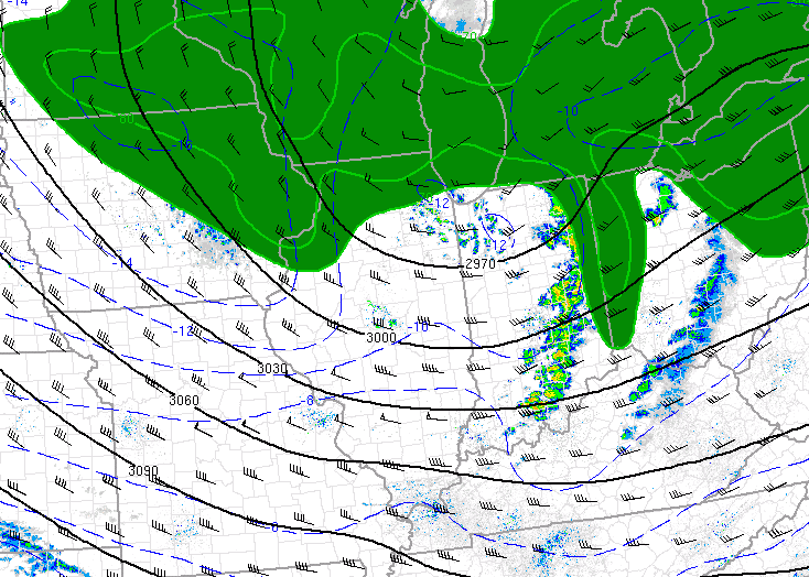
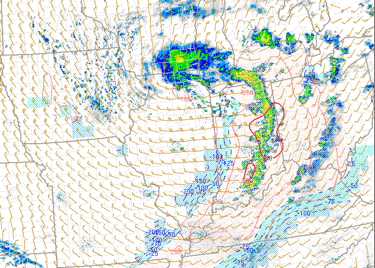
| Figure 1: SPC RAP analysis of 700 mb heights and temperatures valid 2 PM EDT. 700 mb temperatures were cold, on the order of -10 to -12 deg C | Figure 2: SPC RAP analysis of surface based CAPE valid at 2 PM EDT. A narrow of axis of 400-700 J/kg of surface based CAPE. | Figure 3: SPC RAP analysis of effective shear valid at 2 PM EDT. Shear values were quite marginal, only on the order of 20 to 30 knots. |
 |
 |
|
| Figure 4: As a result of the cold mid levels of the atmosphere (as described in figure 1), low and mid level lapse rates were very unstable as depicted in this 2-6 km lapse rate image. | Figure 5: DCAPE, a measure of the strength of rain-cooled downdrafts, was fairly low (only 200 to 400 J/kg) despite the very strong wind gust that was produced. | Figure 6: (Placeholder). |
 |
Media use of NWS Web News Stories is encouraged! Please acknowledge the NWS as the source of any news information accessed from this site. |
|

