Overview
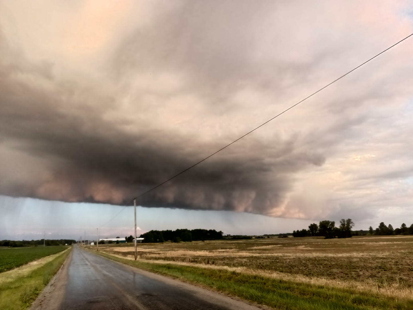
On Sunday June 25, 2023, an approaching cold front encountered a moist and unstable environment resulting in severe thunderstorms that produced very large hail and damaging wind gusts. The largest hailstones were observed in Starke County, IN near the town of Knox, where several 2 to 3" hailstones were measured. Steuben County, IN saw concentrated areas of significant damage due to straightline winds of up to 70 MPH.
Photos & Video
 |
 |
 |
 |
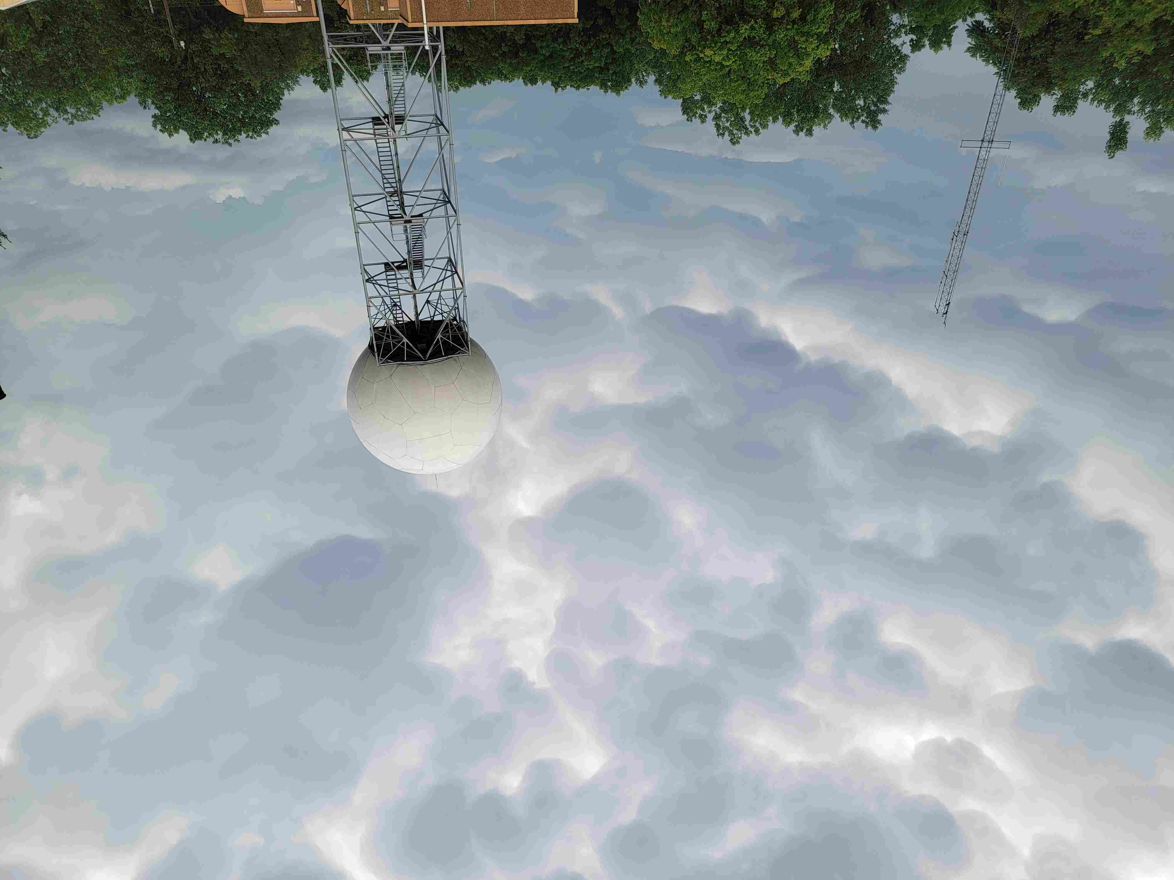
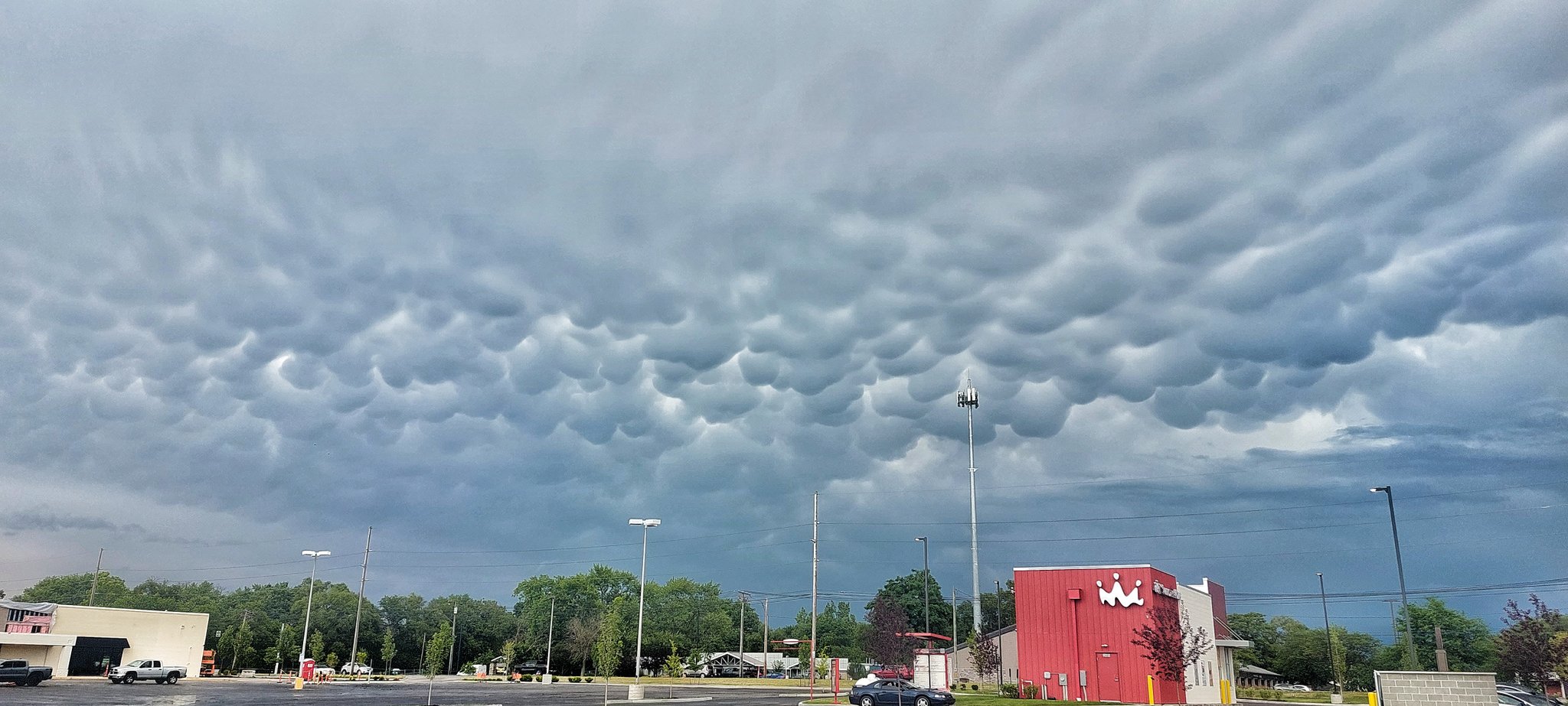
| Mammatus clouds at NWS Northern Indiana (NWS Northern Indiana Lead Meteorologist Pat Murphy) |
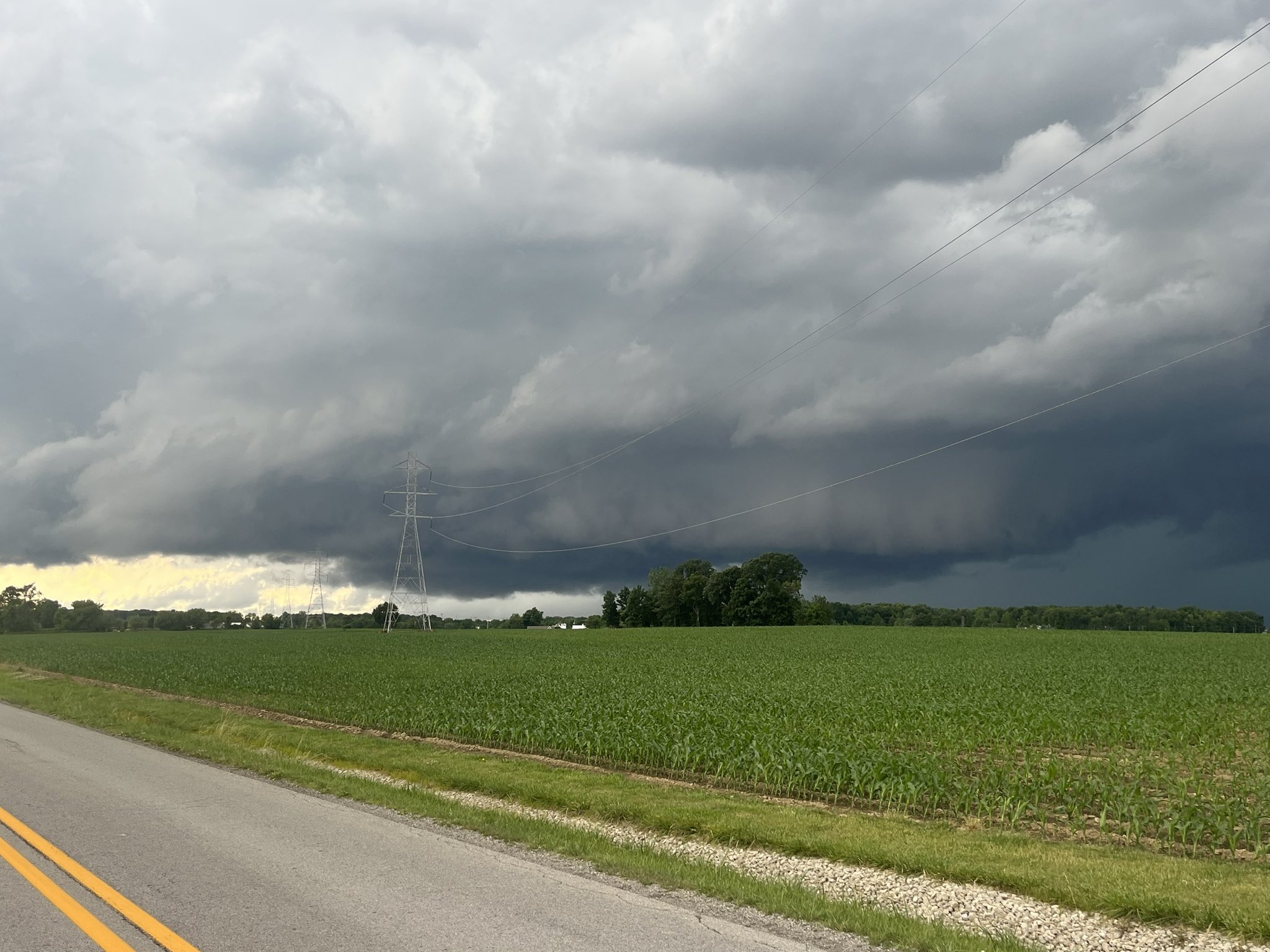
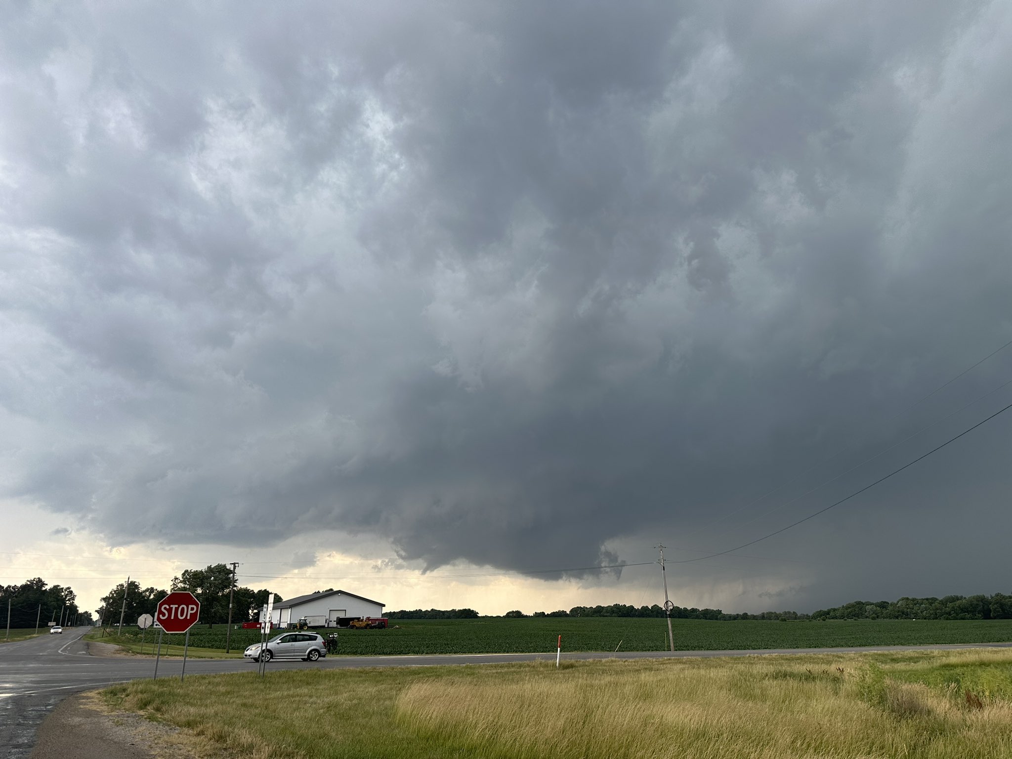
Wall cloud in Zainsville, IN (Helicity Hunters via Twitter) |
Wall cloud in Roann, IN (Northwest Ohio Storm Chasers via Twitter) |
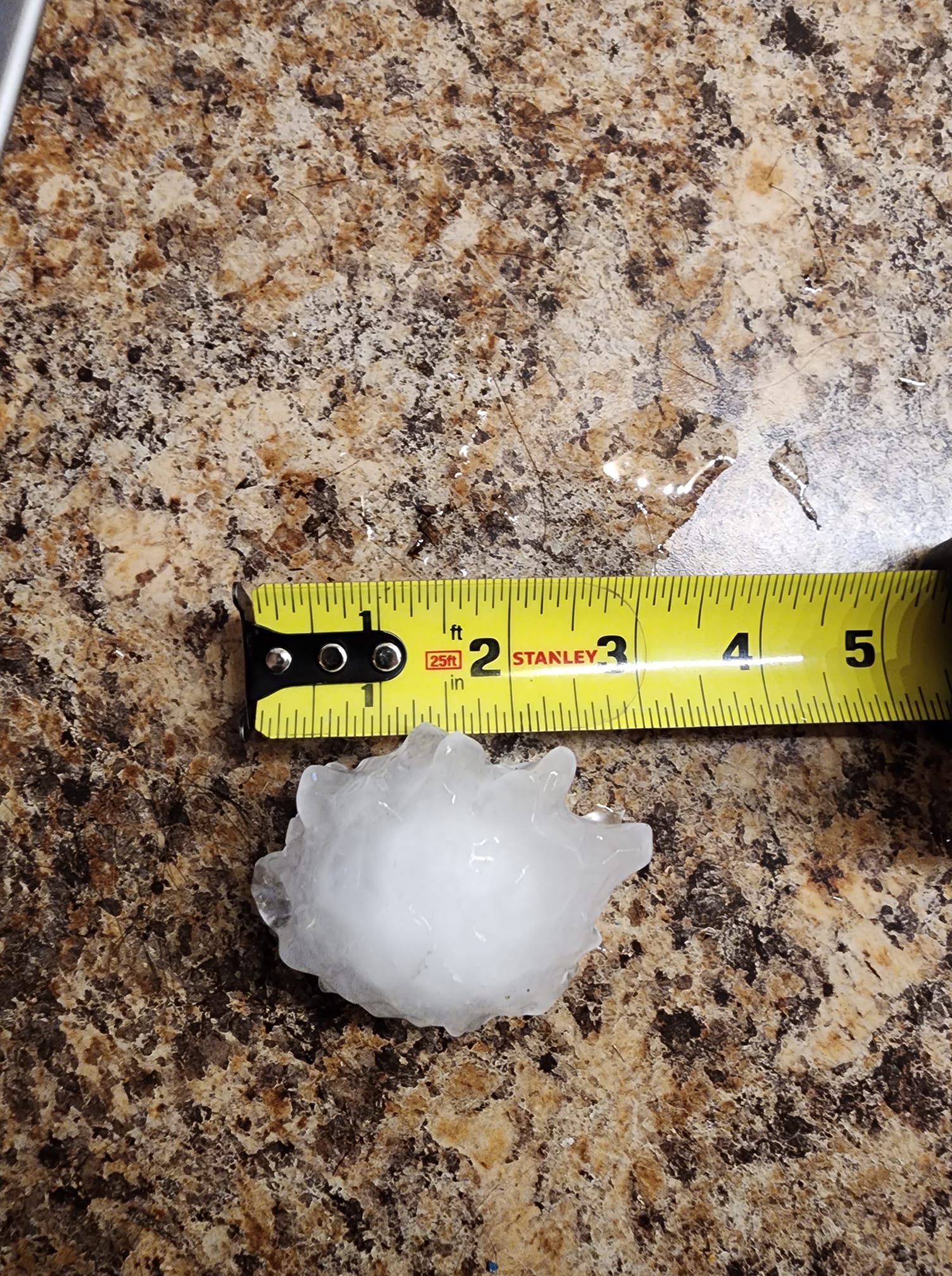
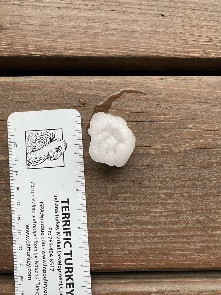
3 inch hailstone measured in Knox, IN in Starke County (Elijah Magiera) |
 |
 |
 |
 |
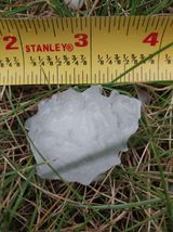
| 1.5 inch hail in La Crosse, IN in La Porte County (Natalie Vernon) |
1 to 1.5 inch hail in North Manchester, IN in Wabash County (Sarah Longanecker) |
Golf ball size hail in Argos, IN in Marshall County (Ryan Jackson) |
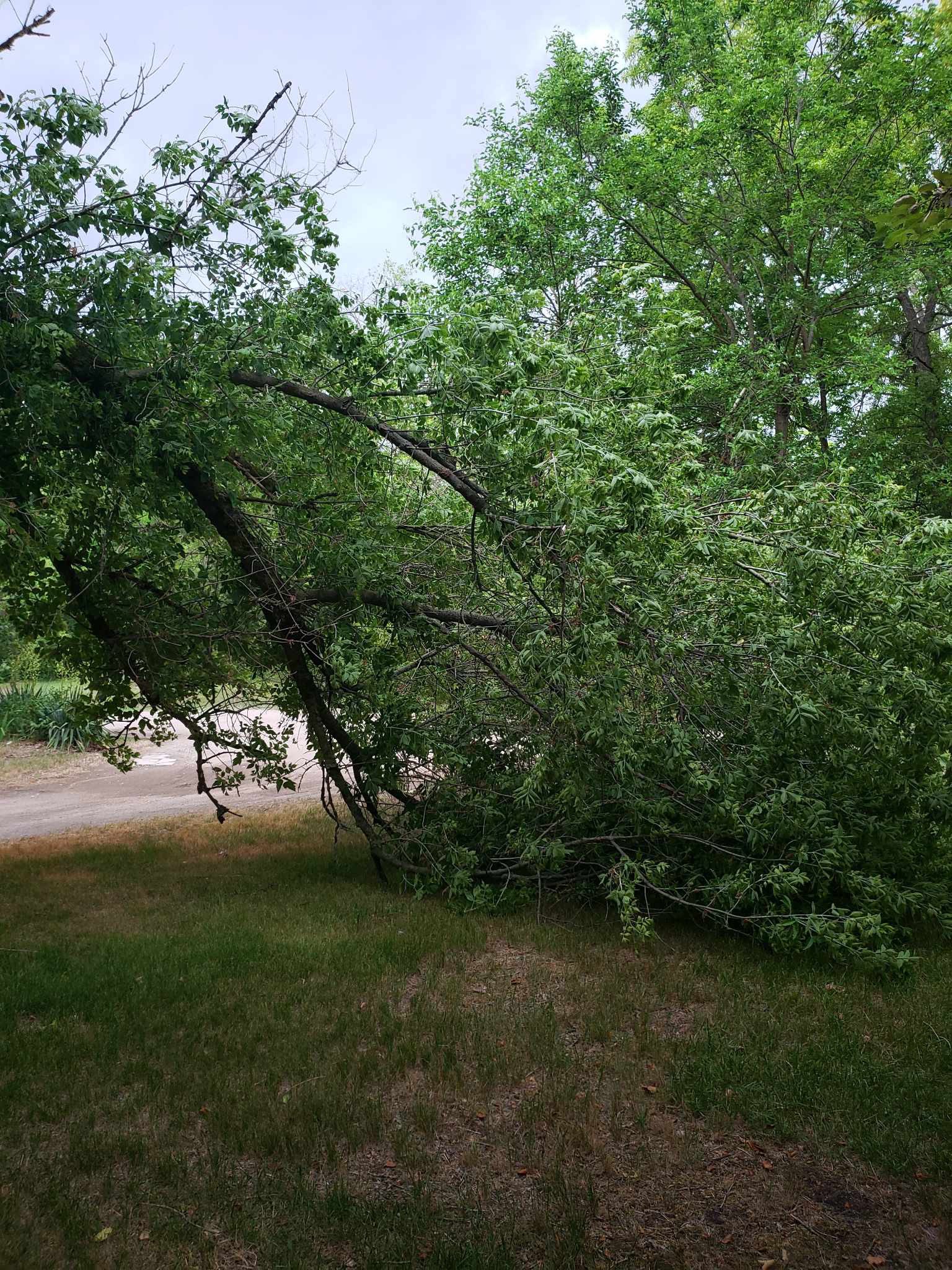
Tree limbs snapped in Rome City, IN in Noble County (Debbie Chapman) |
 |
 |
 |
 |
| Golf ball size hail near Knox, IN in Starke County (Melissa Fletcher) |
Lots of 1" diameter hail in North Manchester, IN in Wabash County (John Spangle) |
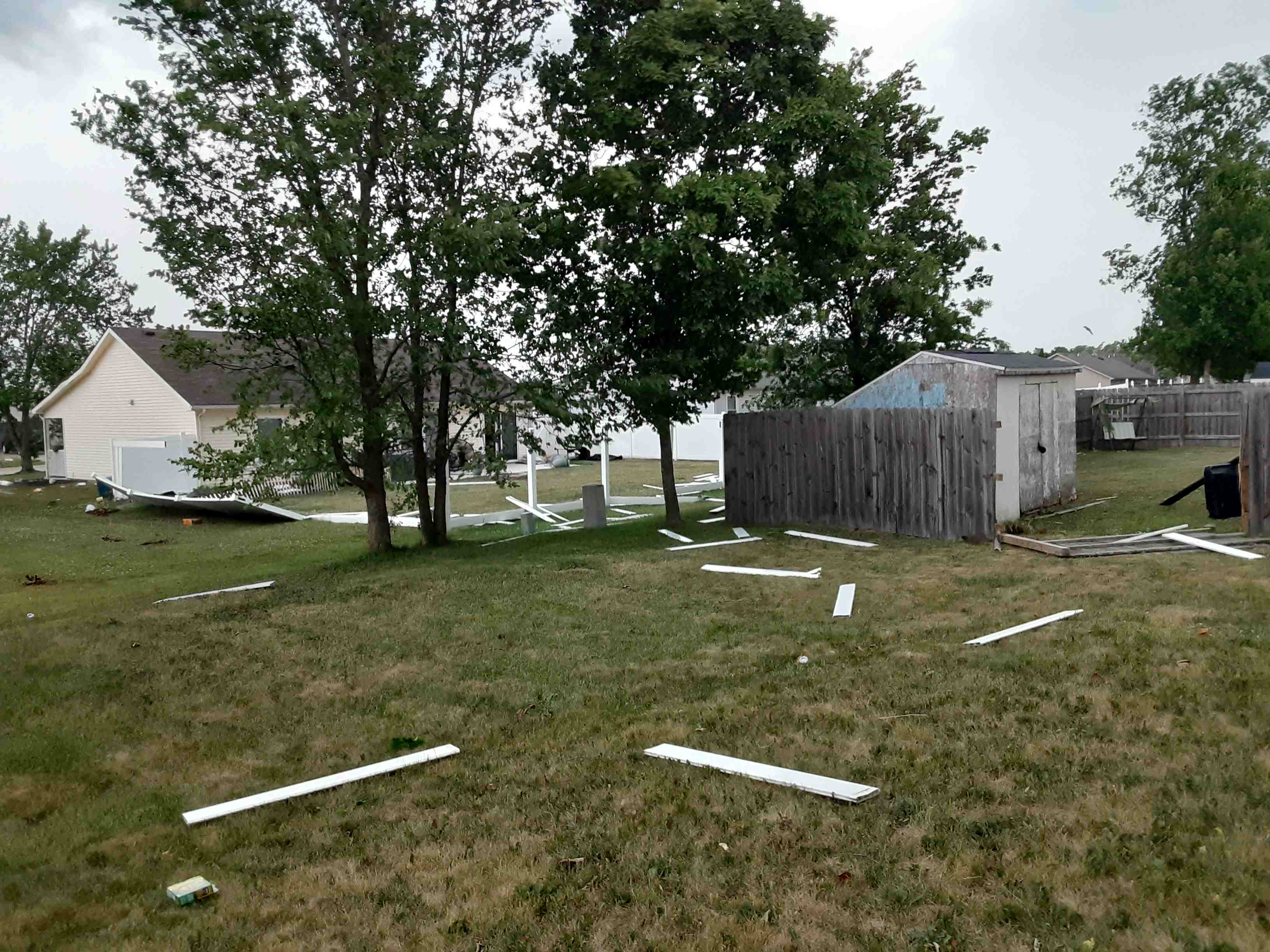
Homes in Auburn, IN sustained damage to siding and roofs from straightline winds (John Culler) |
Shelf cloud in Blackford County, IN (Tara Rice) |
 |
 |
 |
 |
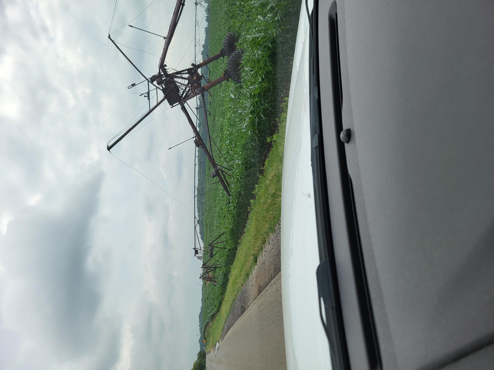
| Damage to a center pivot in Pleasant Lake, IN in Steuben County (Steuben County EM Lee Greenmeyer) |
Lots of 1" diameter hail fell on the northeast side of Fort Wayne, IN in Allen County (AJ Boyer) |
Power poles snapped in Niles, MI (Byron Wx via Twitter) |
Mammatus clouds in South Bend, IN in St. Joseph County (SB Spotter Girl via Twitter) |
Radar
 |
 |
 |
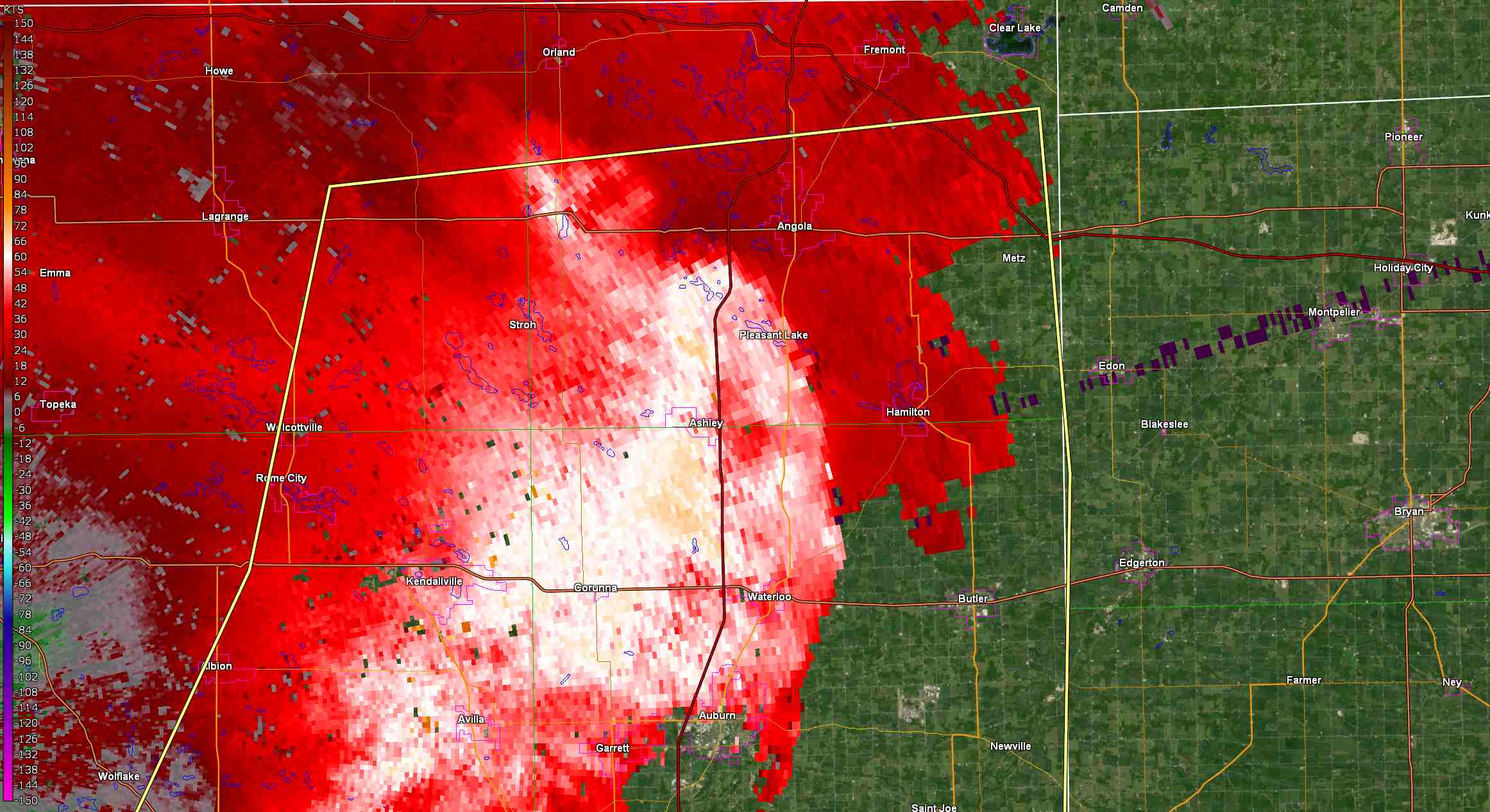 |
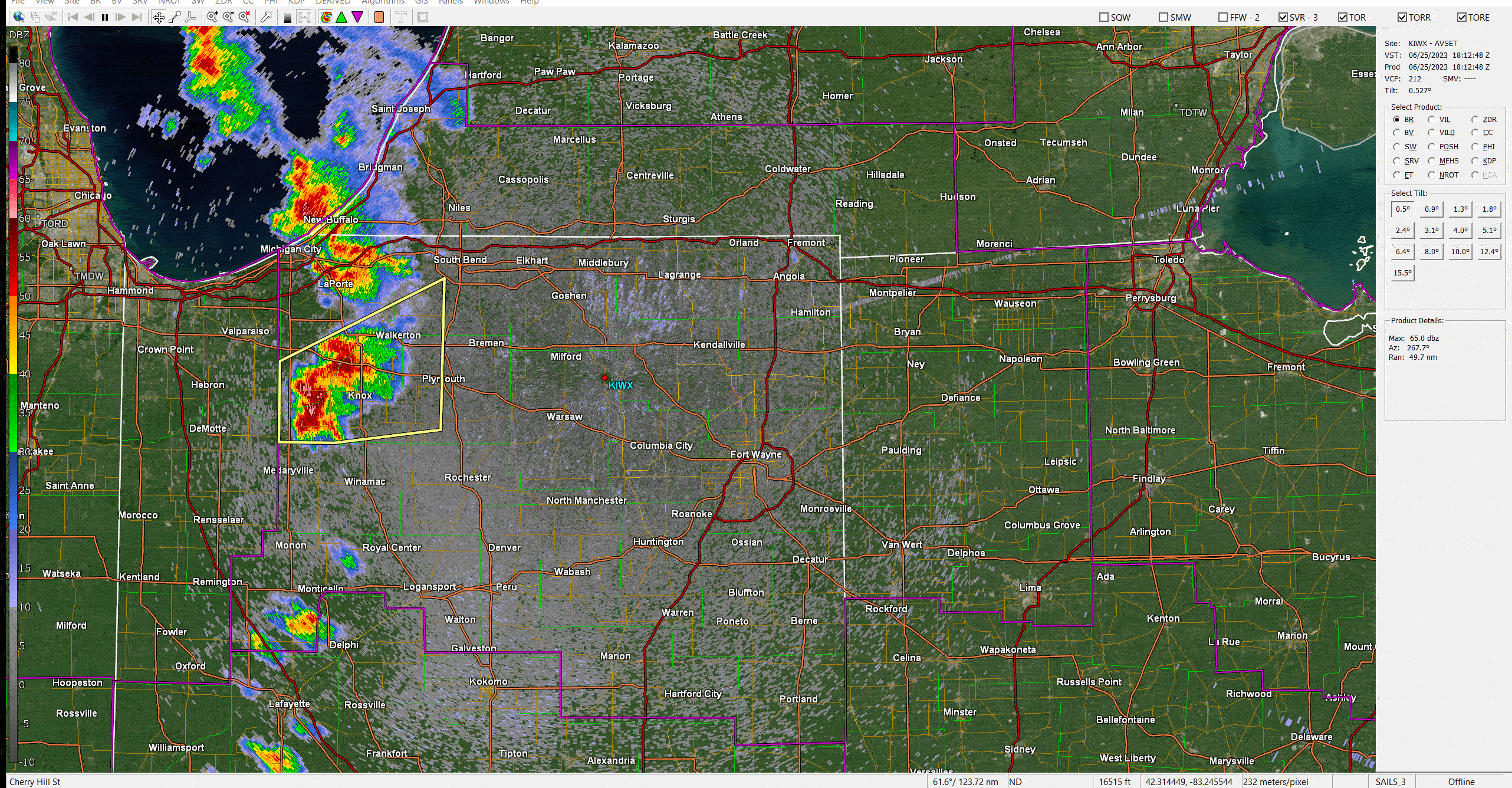
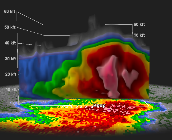
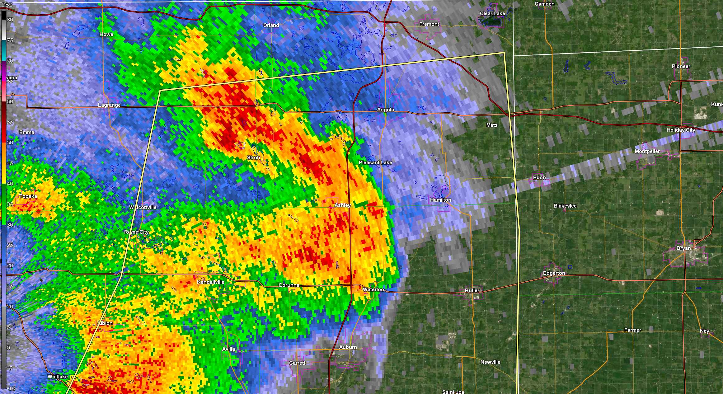
| Base reflectivity loop of the event from 2-6PM EDT with warnings overlaid. Images from GR2Analyst. | Vertical cross section of the storm that produced 3" hail in Knox. This storm had >60 dBZ above 30,000ft! Images from GR2Analyst. | Reflectivity image showing the rear inflow jet that caused damage in Steuben County. Images from GR2Analyst. | IWX Doppler radar measured winds over 70 mph around 2,000 ft above the surface in Steuben County. Images from GR2Analyst. |
Storm Reports
PUBLIC INFORMATION STATEMENT
NATIONAL WEATHER SERVICE NORTHERN INDIANA
542 AM EDT MON JUN 26 2023

...HAIL REPORTS FROM JUNE 25TH 2023...

LOCATION                     SIZE      TIME/DATE       LAT/LON

...INDIANA...

...ALLEN COUNTY...
4 S LEO-CEDARVILLE           1.75 IN   0831 PM 06/25   41.16N/85.02W
4 N NEW HAVEN                1.25 IN   0840 PM 06/25   41.13N/85.01W
2 S ARCOLA                   1.00 IN   0515 PM 06/25   41.08N/85.30W
5 N NEW HAVEN                1.00 IN   0830 PM 06/25   41.14N/85.03W
3 SW WALLEN                  0.88 IN   0515 PM 06/25   41.13N/85.20W
2 N WOODBURN                 0.88 IN   0845 PM 06/25   41.15N/84.85W
3 WSW WOODBURN               0.50 IN   0524 PM 06/25   41.12N/84.91W

...CASS COUNTY...
ROYAL CENTER                 1.00 IN   0254 PM 06/25   40.87N/86.50W

...FULTON COUNTY...
AKRON                        1.00 IN   0330 PM 06/25   41.04N/86.02W
3 N DISKO                    1.00 IN   0412 PM 06/25   41.04N/85.95W
3 SE TIOSA                   1.00 IN   0432 PM 06/25   41.11N/86.17W
ROCHESTER                    0.88 IN   0314 PM 06/25   41.06N/86.20W
4 SW TIOSA                   0.88 IN   0315 PM 06/25   41.11N/86.26W
3 SW TIOSA                   0.88 IN   0319 PM 06/25   41.12N/86.24W

...KOSCIUSKO COUNTY...
MENTONE                      1.00 IN   0345 PM 06/25   41.17N/86.04W
WARSAW                       0.88 IN   0400 PM 06/25   41.24N/85.85W
1 S WARSAW                   0.88 IN   0405 PM 06/25   41.23N/85.85W
1 SW WINONA LAKE             0.75 IN   0400 PM 06/25   41.21N/85.83W
1 SW BURKET                  0.50 IN   0350 PM 06/25   41.14N/85.98W

...LA PORTE COUNTY...
LA CROSSE                    1.50 IN   0212 PM 06/25   41.32N/86.89W

...MARSHALL COUNTY...
PLYMOUTH                     2.75 IN   0306 PM 06/25   41.35N/86.31W
3 E ARGOS                    1.75 IN   0333 PM 06/25   41.24N/86.19W
3 NW TWIN LAKES              1.00 IN   0310 PM 06/25   41.33N/86.40W
ARGOS                        1.00 IN   0317 PM 06/25   41.24N/86.24W
BREMEN                       1.00 IN   0312 PM 06/25   41.45N/86.16W
BOURBON                      0.88 IN   0324 PM 06/25   41.30N/86.12W
1 SE PLYMOUTH                0.75 IN   0307 PM 06/25   41.34N/86.31W

...MIAMI COUNTY...
MACY                         0.88 IN   0350 PM 06/25   40.96N/86.13W

...STARKE COUNTY...
KNOX                         3.00 IN   0240 PM 06/25   41.29N/86.62W
3 NE KNOX                    2.00 IN   0234 PM 06/25   41.32N/86.58W
1 E KNOX                     1.75 IN   0235 PM 06/25   41.29N/86.60W
2 E KNOX                     1.75 IN   0247 PM 06/25   41.29N/86.58W
KNOX                         1.50 IN   0236 PM 06/25   41.29N/86.62W
TOTO                         1.00 IN   0236 PM 06/25   41.26N/86.70W
1 WNW OAK GROVE              0.50 IN   0257 PM 06/25   41.29N/86.51W

...WABASH COUNTY...
NORTH MANCHESTER             1.00 IN   0430 PM 06/25   41.00N/85.77W
1 NE NORTH MANCHESTER        1.00 IN   0501 PM 06/25   41.01N/85.76W

...WHITE COUNTY...
IDAVILLE                     0.88 IN   0238 PM 06/25   40.76N/86.65W

...WHITLEY COUNTY...
COLUMBIA CITY                1.00 IN   0423 PM 06/25   41.16N/85.48W

...OHIO...

...WILLIAMS COUNTY...
BRYAN                        0.75 IN   0519 PM 06/25   41.47N/84.55W
&&

OBSERVATIONS ARE COLLECTED FROM A VARIETY OF SOURCES WITH VARYING
EQUIPMENT AND EXPOSURES. WE THANK ALL VOLUNTEER WEATHER OBSERVERS
FOR THEIR DEDICATION. NOT ALL DATA LISTED ARE CONSIDERED OFFICIAL.

$$
PUBLIC INFORMATION STATEMENT
NATIONAL WEATHER SERVICE NORTHERN INDIANA
615 AM EDT MON JUN 26 2023

...THUNDERSTORM WIND GUSTS FROM JUNE 25TH 2023...

LOCATION                     SPEED     TIME/DATE       LAT/LON

...INDIANA...

...ALLEN COUNTY...
FORT WAYNE INTERNATIONAL AP  41 MPH    0509 PM 06/25   40.98N/85.18W

...CASS COUNTY...
LOGANSPORT                   39 MPH    0520 PM 06/25   40.72N/86.37W
WALTON                       35 MPH    0345 PM 06/25   40.66N/86.22W

...DE KALB COUNTY...
AUBURN DEKALB C              43 MPH    0455 PM 06/25   41.30N/85.07W
GARRETT                      40 MPH    0420 PM 06/25   41.33N/85.13W

...ELKHART COUNTY...
ELKHART MUNICIPA             39 MPH    0317 PM 06/25   41.72N/86.00W

...FULTON COUNTY...
4 W ROCHESTER                62 MPH    0315 PM 06/25   41.05N/86.27W
ROCHESTER                    40 MPH    0315 PM 06/25   41.07N/86.18W

...GRANT COUNTY...
GRANT COUNTY MUNICIPAL APT   35 MPH    0435 PM 06/25   40.48N/85.68W

...HUNTINGTON COUNTY...
HUNTINGTON                   35 MPH    0455 PM 06/25   40.85N/85.45W

...MIAMI COUNTY...
GRISSOM AFB PERU             39 MPH    0355 PM 06/25   40.63N/86.15W

...NOBLE COUNTY...
KENDALLVILLE                 43 MPH    0435 PM 06/25   41.47N/85.25W

...STEUBEN COUNTY...
3 WNW HAMILTON LAKE          70 MPH    0438 PM 06/25   41.57N/84.96W
ANGOLA                       44 MPH    0435 PM 06/25   41.63N/85.08W

...WHITE COUNTY...
MONTICELLO - WHITE COUNTY AR 35 MPH    0555 PM 06/25   40.72N/86.77W

...WHITLEY COUNTY...
NORTHEAST PURDUE AGRICULTURA 60 MPH    0500 PM 06/25   41.11N/85.40W

...MICHIGAN...

...BERRIEN COUNTY...
I94 MM0372                   51 MPH    0259 PM 06/25   42.17N/86.33W
BENTON HARBOR                45 MPH    0246 PM 06/25   42.13N/86.42W

...HILLSDALE COUNTY...
HILLSDALE                    36 MPH    0515 PM 06/25   41.92N/84.58W

...ST. JOSEPH COUNTY...
1.1 S CONSTANTINE (MAWN)     33 MPH    0400 PM 06/25   41.82N/85.66W

...OHIO...

...DEFIANCE COUNTY...
DEFIANCE                     43 MPH    0509 PM 06/25   41.33N/84.43W

...HENRY COUNTY...
DESHLER                      55 MPH    0630 PM 06/25   41.21N/83.91W

...VAN WERT COUNTY...
VAN WERT                     35 MPH    0318 PM 06/25   40.87N/84.59W
VAN WERT                     35 MPH    0555 PM 06/25   40.85N/84.48W

...WILLIAMS COUNTY...
EDON                         55 MPH     0445 PM 06/25   41.54N/84.79W

...MICHIGAN...

...MARITIME STATIONS...
4 NW BRIDGMAN                43 MPH    0240 PM 06/25   41.98N/86.62W
Preliminary Wind Damage Storm Reports...Summary
National Weather Service Northern Indiana
624 AM EDT Mon Jun 26 2023

..TIME...   ...EVENT...      ...CITY LOCATION...     ...LAT.LON...
..DATE...   ....MAG....      ..COUNTY LOCATION..ST.. ...SOURCE....
            ..REMARKS..

0238 PM     Tstm Wnd Dmg     2 SE Shoreham           42.03N 86.49W
06/25/2023                   Berrien            MI   Trained Spotter

            Trained spotter reports small branches 1 to
            3 inches in diameter brought down by gusty
            winds.

0245 PM     Tstm Wnd Dmg     Buchanan                41.83N 86.37W
06/25/2023                   Berrien            MI   Broadcast Media

            Broadcast media reports tree down on Dayton
            Road in Buchanan, MI. Time estimated by
            radar.

0255 PM     Tstm Wnd Dmg     4 WSW Edwardsburg       41.77N 86.16W
06/25/2023                   Cass               MI   Trained Spotter

            Utility pole snapped in half.

0310 PM     Tstm Wnd Dmg     3 SE Edwardsburg        41.77N 86.05W
06/25/2023                   Cass               MI   Public

            Powerlines snapped in Niles, MI on Fir Road
            between Redfield Road and US-12. Time
            estimated from radar.

0312 PM     Tstm Wnd Dmg     Bremen                  41.45N 86.16W
06/25/2023                   Marshall           IN   Public

            Public report on Twitter of quarter size
            hail in Bremen. Time estimated from radar.

0314 PM     Tstm Wnd Dmg     2 E Bremen              41.45N 86.12W
06/25/2023                   Marshall           IN   Public

            Report from mPING: 1-inch tree limbs broken;
            Shingles blown off.

0315 PM     Tstm Wnd Dmg     4 WSW Edwardsburg       41.77N 86.16W
06/25/2023                   Cass               MI   Broadcast Media

            Trees and powerlines down on Fir Rd and
            Redfield Rd.

0324 PM     Tstm Wnd Dmg     Twin Lakes              41.30N 86.36W
06/25/2023                   Marshall           IN   Trained Spotter

            Large tree down, powerlines down, and 1 to 3
            inch tree limbs snapped near Twin Lakes, IN.
            Near the intersection of 13th Road and South
            Rose Road. Time estimated by radar.

0336 PM     Tstm Wnd Dmg     Syracuse                41.43N 85.75W
06/25/2023                   Kosciusko          IN   Broadcast Media

            Broadcast media reports tree and powerlines
            down at the intersection of W Main Street
            and N Dolan Drive in Syracuse, IN. Time
            estimated by radar.

0340 PM     Tstm Wnd Dmg     3 SSW Milford           41.38N 85.87W
06/25/2023                   Kosciusko          IN   Trained Spotter

            Trained spotter reports tree snapped in half
            on their property. Multiple large branches
            across Pinkerton and Price Roads.

0357 PM     Tstm Wnd Dmg     1 WNW Rome City         41.50N 85.38W
06/25/2023                   Noble              IN   Trained Spotter

            Several 1 ft diameter tree limbs downed.
            Appear healthy from photos.

0400 PM     Tstm Wnd Dmg     Larwill                 41.18N 85.62W
06/25/2023                   Whitley            IN   Emergency Mngr

            Emergency Manager reports tree down onto
            vehicle in Larwill. No known injuries. Time
            estimated from radar.

0400 PM     Tstm Wnd Dmg     1 NNE Brushy Prairie    41.66N 85.24W
06/25/2023                   Lagrange           IN   Broadcast Media

            Multiple trees with snapped limbs 6 to 12
            inches in diameter in Rome City. Photos from
            Twitter. Time estimated from radar.

0403 PM     Tstm Wnd Dmg     Larwill                 41.18N 85.62W
06/25/2023                   Whitley            IN   Broadcast Media

            Powerlines down in Larwill. Time estimated
            by radar.

0425 PM     Tstm Wnd Dmg     2 SSE York              41.66N 84.81W
06/25/2023                   Steuben            IN   Emergency Mngr

            Emergency manager reports damage to a barn.
            Part of barn roof in the roadway at CR 950 E
            and CR 100 N. Time estimated from radar.

0425 PM     Tstm Wnd Dmg     1 SSW Salem Center      41.57N 85.15W
06/25/2023                   Steuben            IN   Emergency Mngr

            EMA volunteer reports structural damage to a
            large barn and a small outbuilding destroyed
            by strong winds. Time estimated from radar.

0425 PM     Tstm Wnd Dmg     2 SSW Salem Center      41.56N 85.16W
06/25/2023                   Steuben            IN   Emergency Mngr

            Salem Township Fire Department has wind
            damage to their building including a portion
            of the roof missing and damage to a wall.
            Reported by Steuben County emergency
            manager.

0430 PM     Tstm Wnd Dmg     1 S Angola              41.63N 85.00W
06/25/2023                   Steuben            IN   Fire Dept/Rescue

            Damage at a car dealership at 1006 South
            Wayne Street in Angola, IN. Damage to
            vehicles and structures. Reported by Angola
            FD, relayed by emergency manager. Time
            estimated via radar.

0430 PM     Tstm Wnd Dmg     1 SE Hamilton Lake      41.54N 84.91W
06/25/2023                   Steuben            IN   Public

            Powerlines down in northeast Hamilton, IN.
            Time estimated from radar.

0435 PM     Tstm Wnd Dmg     Angola                  41.64N 85.00W
06/25/2023                   Steuben            IN   Amateur Radio

            10 inch diameter tree branches down in
            Angola.

0444 PM     Tstm Wnd Dmg     Ligonier                41.46N 85.60W
06/25/2023                   Noble              IN   Broadcast Media

            Kenny Park. 18 Inch diameter tree snapped,
            appears healthy. Several limbs downed.

0452 PM     Tstm Wnd Dmg     Pioneer                 41.68N 84.55W
06/25/2023                   Williams           OH   Public

            Several limbs downed that were between 3-8
            inches in diameter, estimated wind gust of
            50 to 60 mph.

0501 PM     Tstm Wnd Dmg     3 SW Leo-Cedarville     41.17N 85.06W
06/25/2023                   Allen              IN   Amateur Radio

            Report of 3 inch tree limbs down at the
            intersection of Newnum Rd and St. Joe Rd.
            Time estimated from radar.

0501 PM     Tstm Wnd Dmg     New Haven               41.07N 85.03W
06/25/2023                   Allen              IN   Amateur Radio

            18 inch tree down on Hatzel Road in New
            Haven, IN.

0512 PM     Tstm Wnd Dmg     3 NNW Fort Wayne        41.11N 85.15W
06/25/2023                   Allen              IN   Broadcast Media

            3 to 6 inch tree limb down on Sherman Blvd.
            Time estimated from radar.

0536 PM     Tstm Wnd Dmg     2 SW Edon               41.54N 84.79W
06/25/2023                   Williams           OH   Trained Spotter

            Several 6 to 8 inch diameter limbs downed,
            minor crop damage from strong winds.
            Estimated wind gust to 50 to 60 mph.

0539 PM     Tstm Wnd Dmg     2 NE Colton             41.49N 83.92W
06/25/2023                   Fulton             OH   Emergency Mngr

            Per county dispatch, emergency manager
            reports a tree that fell onto an occupied
            van with 3 kids and 1 adult female inside.
            No major injuries reported but occupants
            were covered in broken glass.

0606 PM     Tstm Wnd Dmg     New Bavaria             41.21N 84.17W
06/25/2023                   Henry              OH   Emergency Mngr

            Powerlines and tree limbs down on 830 Walnut
            Street in New Bavaria, OH. Time estimated
            from radar.

0819 PM     Tstm Wnd Dmg     1 NNE Wauseon           41.56N 84.13W
06/25/2023                   Fulton             OH   Public

            Report from mPING: 3-inch tree limbs broken;
            Power poles broken.

0834 PM     Tstm Wnd Dmg     3 NW New Haven          41.10N 85.05W
06/25/2023                   Allen              IN   Public

            Report from mPING: 1-inch tree limbs broken;
            Shingles blown off.
Rain Reports
Public Information Statement
National Weather Service Northern Indiana
1038 AM EDT Mon Jun 26 2023

...PRECIPITATION REPORTS FOR PAST 48 HOURS...

Location                     Amount    Time/Date       Lat/Lon

...Indiana...

...Adams County...
0.8 N Linn Grove             0.73 in   0245 AM 06/26   40.66N/85.03W
1.8 E Berne                  0.68 in   0800 AM 06/26   40.67N/84.92W

...Allen County...
Fort Wayne 10.4 N            2.10 in   0700 AM 06/26   41.22N/85.14W
Fort Wayne 8.0 N             1.71 in   0700 AM 06/26   41.19N/85.11W
4 ENE Wallen                 1.70 in   0915 AM 06/26   41.18N/85.10W
Harlan 2.2 ENE               1.53 in   0700 AM 06/26   41.20N/84.88W
Woodburn 2.6 NNW             1.47 in   0900 AM 06/26   41.16N/84.88W
Spencerville                 1.46 in   0445 AM 06/26   41.25N/84.89W
Fort Wayne 6.8 NE            1.45 in   0700 AM 06/26   41.13N/85.03W
Fort Wayne 2.6 NW            1.42 in   0700 AM 06/26   41.10N/85.18W
Fort Wayne 4.1 NE            1.33 in   0700 AM 06/26   41.12N/85.09W
Woodburn 2.8 WSW             1.25 in   0700 AM 06/26   41.12N/84.91W
Fort Wayne 5.7 NE            1.00 in   0700 AM 06/26   41.13N/85.06W
Fort Wayne 2.6 NE            1.00 in   0700 AM 06/26   41.10N/85.11W
Fort Wayne 1.0 NE            0.94 in   0557 AM 06/26   41.08N/85.13W
Fort Wayne 9.3 W             0.94 in   0700 AM 06/26   41.05N/85.31W
Fort Wayne 7.1 WSW           0.85 in   0800 AM 06/26   41.05N/85.27W
Fort Wayne 10.1 WSW          0.75 in   0700 AM 06/26   41.03N/85.32W
Ellisville 0.3 W             0.57 in   0730 AM 06/26   41.02N/85.29W
Fort Wayne 1.9 SSW           0.55 in   0630 AM 06/26   41.05N/85.15W
Fort Wayne 9.1 SE            0.41 in   0700 AM 06/26   40.99N/85.00W
Hoagland 1.5 SSW             0.38 in   0800 AM 06/26   40.93N/85.00W
Fort Wayne 1.9 S             0.34 in   0445 AM 06/26   41.05N/85.14W
Fort Wayne 1.6 S             0.33 in   0800 AM 06/26   41.05N/85.14W
Fort Wayne International Ap  0.33 in   0354 AM 06/26   40.98N/85.18W
Monroeville 0.2 ESE          0.26 in   0700 AM 06/26   40.97N/84.86W

...Blackford County...
Hartford City 4 ESE          0.63 in   0800 AM 06/26   40.44N/85.29W
(KA9VIS) Hartford City 0.7 N 0.60 in   0700 AM 06/26   40.46N/85.37W

...Cass County...
Walton                       0.28 in   0446 AM 06/26   40.66N/86.22W
Young America                0.27 in   0800 AM 06/26   40.57N/86.33W
Galveston                    0.12 in   0445 AM 06/26   40.56N/86.19W

...De Kalb County...
0.6 S Garrett                1.46 in   0700 AM 06/26   41.34N/85.13W
1.7 SE Butler                0.82 in   0840 AM 06/26   41.41N/84.85W
Hamilton 3.0 ESE             0.80 in   0630 AM 06/26   41.52N/84.86W
Garrett                      0.78 in   0930 AM 06/26   41.33N/85.13W

...Elkhart County...
New Paris 1.0 SW             1.13 in   0700 AM 06/26   41.49N/85.84W
Syracuse 4.4 NNW             0.95 in   0700 AM 06/26   41.48N/85.77W
Ligonier 4.3 WNW             0.90 in   0800 AM 06/26   41.48N/85.67W
Nappanee 4.8 NE              0.87 in   0700 AM 06/26   41.50N/85.92W
Middlebury 2.6 WSW           0.82 in   0700 AM 06/26   41.66N/85.76W
Goshen 2.3 WNW               0.81 in   0700 AM 06/26   41.59N/85.88W
Goshen 1.2 SW                0.76 in   0700 AM 06/26   41.57N/85.85W
Goshen 3.0 WSW               0.75 in   0700 AM 06/26   41.56N/85.88W
Goshen 1.8 SE                0.71 in   0800 AM 06/26   41.56N/85.81W
Wakarusa 2.4 NNE             0.70 in   0700 AM 06/26   41.57N/85.99W
Goshen 1.4 SSE               0.70 in   0700 AM 06/26   41.56N/85.83W
Goshen 2.8 NW                0.70 in   0925 AM 06/26   41.60N/85.88W
Jamestown                    0.70 in   0928 AM 06/26   41.64N/86.04W
Jamestown                    0.69 in   0908 AM 06/26   41.64N/86.04W
Elkhart 4.8 SW               0.68 in   0700 AM 06/26   41.64N/86.04W
Goshen 4.6 N                 0.56 in   0700 AM 06/26   41.64N/85.83W
Goshen 3.5 NNW               0.56 in   0745 AM 06/26   41.62N/85.87W
Elkhart Municipa             0.53 in   0915 AM 06/26   41.72N/86.00W

...Fulton County...
Rochester                    0.85 in   0700 AM 06/26   41.07N/86.21W
Kewanna 4.9 S                0.77 in   0700 AM 06/26   40.95N/86.41W
Akron                        0.55 in   0628 AM 06/26   41.05N/86.03W

...Grant County...
(KC9QCJ) Shamrock Lakes 3.0  0.65 in   0700 AM 06/26   40.45N/85.45W
Upland 2.4 SSE               0.61 in   0700 AM 06/26   40.43N/85.50W
Marion 5.6 NE                0.40 in   0600 AM 06/26   40.60N/85.59W
2.2 N Marion                 0.37 in   0701 AM 06/26   40.58N/85.66W
(KB9CRA)Gas City 0.3 N       0.28 in   0700 AM 06/26   40.49N/85.61W
Grant County Municipal Apt   0.09 in   0435 AM 06/26   40.48N/85.68W

...Huntington County...
2.4 NW Warren                1.11 in   0245 AM 06/26   40.71N/85.45W
Huntington 0.3 W             0.79 in   0700 AM 06/26   40.88N/85.51W
Huntington                   0.77 in   0855 AM 06/26   40.85N/85.45W
1.7 E Bowerstown             0.62 in   0400 AM 06/26   40.90N/85.41W

...Jay County...
(W9JKL) Portland 0.6 SSW     1.15 in   0700 AM 06/26   40.42N/84.99W
Portland 2.3 S               1.04 in   0700 AM 06/26   40.40N/84.98W
(KC9LQY) Portland 5.4 SW     1.00 in   0700 AM 06/26   40.39N/85.06W
Redkey 0.6 SE                0.64 in   0705 AM 06/26   40.34N/85.14W

...Kosciusko County...
Silver Lake                  1.80 in   1051 PM 06/25   41.07N/85.89W
Cromwell 2.9 W               1.79 in   0700 AM 06/26   41.40N/85.67W
Claypool 1.2 E               1.77 in   0655 AM 06/26   41.13N/85.86W
Warsaw 5 SW                  1.77 in   0700 AM 06/26   41.17N/85.92W
Milford 2.7 SSW              1.61 in   0600 AM 06/26   41.38N/85.87W
Syracuse 3.0 ESE             1.61 in   0800 AM 06/26   41.41N/85.70W
NWS Northern Indiana         1.59 in   0800 AM 06/26   41.36N/85.70W
Milford 0.9 N                1.54 in   0700 AM 06/26   41.42N/85.85W
Warsaw 3.0 SE                1.52 in   0700 AM 06/26   41.21N/85.80W
Leesburg 0.1 WNW             1.50 in   0600 AM 06/26   41.33N/85.85W
Warsaw 5.3 WNW               1.50 in   0926 AM 06/26   41.27N/85.94W
Leesburg 6.7 ESE             1.26 in   0700 AM 06/26   41.31N/85.72W
Warsaw 3.7 E                 1.23 in   0730 AM 06/26   41.23N/85.78W
Warsaw 1.2 NNE               1.03 in   0700 AM 06/26   41.25N/85.84W
Warsaw 1.4 N                 1.00 in   0630 AM 06/26   41.26N/85.85W
1 SW Sevastopol              0.81 in   0449 AM 06/26   41.11N/86.04W
Warsaw Muni                  0.50 in   0915 AM 06/26   41.27N/85.83W

...La Porte County...
La Porte 5.9 NW              1.40 in   0800 AM 06/26   41.66N/86.80W
0.8 W La Porte               1.35 in   1258 AM 06/26   41.61N/86.73W
Trail Creek 3.0 SE           1.34 in   0800 AM 06/26   41.67N/86.81W
La Porte 6.8 SW              1.19 in   0800 AM 06/26   41.55N/86.82W
Trail Creek 1.0 NNW          1.07 in   0800 AM 06/26   41.71N/86.86W
La Porte 2.3 ESE             0.96 in   0930 AM 06/26   41.59N/86.68W
Mill Creek 1.9 NNE           0.95 in   0715 AM 06/26   41.61N/86.52W
Wanatah 4.4 ESE              0.84 in   0900 AM 06/26   41.41N/86.81W
New Carlisle 3.0 WNW         0.84 in   0900 AM 06/26   41.72N/86.57W
La Porte                     0.76 in   0915 AM 06/26   41.57N/86.73W
La Crosse 3.2 NW             0.72 in   0800 AM 06/26   41.35N/86.93W
La Crosse 1.2 W              0.53 in   0800 AM 06/26   41.32N/86.91W

...Lagrange County...
Wolcottville 1.1 WNW         1.06 in   0809 AM 06/26   41.53N/85.39W
Lagrange 4.6 ESE             0.87 in   0850 AM 06/26   41.62N/85.34W
LaGrange 1.3 ENE             0.77 in   0808 AM 06/26   41.65N/85.40W
LaGrange 9.9 E               0.62 in   0632 AM 06/26   41.65N/85.23W

...Marshall County...
Tippecanoe 0.8 S             1.25 in   0700 AM 06/26   41.20N/86.11W
Plymouth 2.5 WSW             1.19 in   0430 AM 06/26   41.33N/86.36W

...Miami County...
Macy 3.6 SSE                 0.71 in   0800 AM 06/26   40.91N/86.10W
Denver 1.3 NE                0.59 in   0700 AM 06/26   40.88N/86.06W
Peru                         0.57 in   0430 AM 06/26   40.75N/86.07W
Denver 0.5 SSE               0.55 in   0700 AM 06/26   40.86N/86.07W
0.8 NW Peru                  0.47 in   0700 AM 06/26   40.76N/86.07W
Peru 4.6 SSE                 0.39 in   0600 AM 06/26   40.70N/86.02W
Amboy                        0.22 in   0445 AM 06/26   40.59N/85.98W

...Noble County...
Albion 3.7 S                 1.10 in   0930 AM 06/26   41.34N/85.42W
Albion 2.8 ENE               0.97 in   0800 AM 06/26   41.40N/85.37W
Cosperville                  0.74 in   0400 AM 06/26   41.48N/85.48W
Kendallville 4.5 NW          0.68 in   0700 AM 06/26   41.50N/85.31W
Kendallville                 0.44 in   0915 AM 06/26   41.47N/85.25W

...Pulaski County...
Francesville                 0.77 in   0800 AM 06/26   40.98N/86.89W
1.3 SW Ora                   0.60 in   0345 AM 06/26   41.16N/86.56W

...St. Joseph County...
South Bend 4.0 SSW           0.94 in   0800 AM 06/26   41.63N/86.31W
South Bend International Ap  0.80 in   0439 AM 06/26   41.70N/86.32W
New Carlisle                 0.74 in   0800 AM 06/26   41.71N/86.50W
South Bend 4.6 SSE           0.70 in   0847 AM 06/26   41.61N/86.24W
Mishawaka 3.9 ENE            0.69 in   0710 AM 06/26   41.68N/86.10W
Granger 1.8 ENE              0.67 in   0700 AM 06/26   41.75N/86.11W
South Bend                   0.66 in   1158 PM 06/25   41.70N/86.25W
South Bend 3.3 SE            0.65 in   0645 AM 06/26   41.64N/86.23W
South Bend 4.6 SE            0.64 in   0800 AM 06/26   41.62N/86.22W
Mishawaka 2.0 E              0.53 in   0700 AM 06/26   41.66N/86.13W
0.9 W Roseland               0.33 in   0915 AM 06/26   41.72N/86.27W

...Starke County...
Winona                       0.68 in   0843 AM 06/26   41.24N/86.57W
3.5 N Brems                  0.13 in   0400 AM 06/26   41.39N/86.71W

...Steuben County...
0.7 E Hamilton               0.89 in   0445 AM 06/26   41.53N/84.90W
Hudson 6.4 WNW               0.87 in   0800 AM 06/26   41.58N/85.19W
Pigeon Creek                 0.87 in   0915 AM 06/26   41.63N/85.11W
Angola                       0.82 in   0925 AM 06/26   41.63N/85.09W
0.7 E Hamilton               0.74 in   0845 AM 06/26   41.53N/84.90W
Pigeon Creek                 0.66 in   0400 AM 06/26   41.63N/85.11W
Angola 8.7 ESE               0.65 in   0700 AM 06/26   41.61N/84.84W
Angola 1.2 S                 0.62 in   0600 AM 06/26   41.62N/85.00W
Pigeon Creek                 0.59 in   0815 AM 06/26   41.63N/85.11W
Angola 8.8 ESE               0.58 in   0800 AM 06/26   41.62N/84.83W
Hudson 4.1 NNW               0.52 in   0700 AM 06/26   41.59N/85.10W
Angola 4.5 NW                0.50 in   0700 AM 06/26   41.68N/85.07W
Hudson 4.6 N                 0.50 in   0715 AM 06/26   41.60N/85.09W
Angola 4.1 N                 0.41 in   0545 AM 06/26   41.70N/84.99W
Hudson 0.3 SE                0.36 in   0530 AM 06/26   41.53N/85.08W
Angola 6.2 NW                0.30 in   0700 AM 06/26   41.71N/85.07W

...Wabash County...
La Fontaine 1.1 NW           0.55 in   0600 AM 06/26   40.68N/85.74W
0.7 SE Wabash                0.44 in   0430 AM 06/26   40.79N/85.82W

...Wells County...
Markle 5.1 NE                0.73 in   0700 AM 06/26   40.89N/85.28W
Craigville 2.7 NW            0.66 in   0800 AM 06/26   40.80N/85.13W

...White County...
Monticello - White County Ar 0.94 in   0355 AM 06/26   40.72N/86.77W
Monticello 0.9 E             0.92 in   0700 AM 06/26   40.75N/86.75W
Monticello 5.5 NNW           0.80 in   0800 AM 06/26   40.82N/86.79W
Norway                       0.80 in   0445 AM 06/26   40.78N/86.76W
Monticello - White County Ar 0.79 in   0855 AM 06/26   40.72N/86.77W
Norway                       0.78 in   0845 AM 06/26   40.78N/86.76W
5.6 N Badger Grove           0.66 in   0700 AM 06/26   40.67N/86.95W

...Whitley County...
1 WSW Columbia City          2.26 in   0955 PM 06/25   41.16N/85.49W
Columbia City 0.2 NE         2.03 in   0719 AM 06/26   41.16N/85.48W
Columbia City 4.6 S          1.99 in   0600 AM 06/26   41.09N/85.47W
Columbia City 6.8 NNE        1.47 in   0700 AM 06/26   41.25N/85.42W
Tri-Lakes 3.0 N              1.43 in   0605 AM 06/26   41.26N/85.49W
Columbia City 7.4 N          1.30 in   0709 AM 06/26   41.26N/85.50W
Columbia City 5.4 N          1.28 in   0600 AM 06/26   41.24N/85.49W

...Michigan...

...Berrien County...
Bertrand                     1.17 in   0800 AM 06/26   41.77N/86.26W
Buchanan 1.4 ESE             0.93 in   0700 AM 06/26   41.82N/86.34W
Niles 2.7 W                  0.74 in   0800 AM 06/26   41.84N/86.30W
St. Joseph 2.8 SSE           0.56 in   0700 AM 06/26   42.06N/86.47W
Shoreham 2.0 SE              0.49 in   0800 AM 06/26   42.03N/86.49W
Niles                        0.49 in   0909 AM 06/26   41.83N/86.25W
Stevensville 1.7 SSE         0.46 in   0545 AM 06/26   41.99N/86.51W
Benton Harbor                0.46 in   0853 AM 06/26   42.13N/86.42W
3.7 S Watervliet             0.40 in   0900 AM 06/26   42.13N/86.25W
St. Joseph 1.5 SSE           0.35 in   0700 AM 06/26   42.08N/86.48W

...Branch County...
Quincy 0.3 NE                0.40 in   0700 AM 06/26   41.95N/84.88W

...Cass County...
2 NNW Edwardsburg            1.04 in   0700 AM 06/26   41.84N/86.10W
Cassopolis 9.0 SSE           0.81 in   0700 AM 06/26   41.79N/85.95W
Niles 3.5 E                  0.45 in   0900 AM 06/26   41.84N/86.18W

...Hillsdale County...
Jonesville 5.9 ENE           0.35 in   0700 AM 06/26   42.01N/84.56W
Osseo 2.7 NE                 0.23 in   0830 AM 06/26   41.90N/84.49W
Hillsdale 2.5 ESE            0.22 in   0800 AM 06/26   41.91N/84.59W
Hillsdale                    0.15 in   0435 AM 06/26   41.92N/84.58W
Jonesville 0.2 WSW           0.14 in   0652 AM 06/26   41.98N/84.67W

...St. Joseph County...
Constantine 1.9 E            0.66 in   0742 AM 06/26   41.84N/85.63W
2.0 SE Mendon                0.43 in   0400 AM 06/26   41.98N/85.43W
Three Rivers 2.4 NE          0.38 in   0700 AM 06/26   41.97N/85.60W
Sturgis Kirsch               0.31 in   0915 AM 06/26   41.80N/85.43W
2.0 SE Mendon                0.29 in   0900 AM 06/26   41.98N/85.43W
1 SE Mottville               0.22 in   0710 AM 06/26   41.79N/85.74W

...Ohio...

...Allen County...
Lima 3.0 SSE                 0.39 in   0600 AM 06/26   40.70N/84.10W
Delphos 2.3 ESE              0.27 in   0600 AM 06/26   40.83N/84.30W
Lima 2.7 NE                  0.26 in   0700 AM 06/26   40.77N/84.08W
Elida 1.4 WNW                0.23 in   0650 AM 06/26   40.80N/84.22W
Lima                         0.22 in   0853 AM 06/26   40.70N/84.02W
Lima 7.3 SE                  0.21 in   0700 AM 06/26   40.66N/84.03W
Lima 1 N                     0.19 in   0450 AM 06/26   40.78N/84.12W
Bluffton                     0.06 in   0910 AM 06/26   40.89N/83.89W

...Defiance County...
Defiance                     1.09 in   0853 AM 06/26   41.33N/84.43W

...Fulton County...
Wauseon 1.8 S                1.09 in   0700 AM 06/26   41.53N/84.14W
Fayette 4.3 ESE              0.83 in   0700 AM 06/26   41.65N/84.25W
4.6 SW Morenci  (R2)  (R2)   0.82 in   0900 AM 06/26   41.66N/84.25W
Archbold 4.7 NW              0.75 in   0630 AM 06/26   41.57N/84.36W
Swanton 4.0 S                0.68 in   0707 AM 06/26   41.53N/83.91W

...Henry County...
Napoleon 4.5 NNW             0.87 in   0700 AM 06/26   41.46N/84.15W
Liberty Center 0.3 NE        0.86 in   0700 AM 06/26   41.45N/84.00W
Napoleon 0.6 WSW             0.72 in   0800 AM 06/26   41.39N/84.14W
Napoleon 1 SW                0.68 in   0700 AM 06/26   41.38N/84.15W
McClure 3.4 SSE              0.48 in   0700 AM 06/26   41.33N/83.91W

...Paulding County...
Paulding 1.4 NNE             0.71 in   0700 AM 06/26   41.15N/84.57W

...Putnam County...
Ottawa 1.0 N                 0.25 in   0700 AM 06/26   41.04N/84.04W
Vaughnsville                 0.19 in   0445 AM 06/26   40.88N/84.15W

...Van Wert County...
Van Wert                     1.21 in   0445 AM 06/26   40.87N/84.59W
2 W Delphos                  0.61 in   1100 PM 06/25   40.84N/84.38W

...Williams County...
Alvordton 0.5 E              1.38 in   0700 AM 06/26   41.67N/84.42W
Pioneer 2.3 S                1.35 in   0700 AM 06/26   41.65N/84.55W
1.2 E Bryan                  0.83 in   0800 AM 06/26   41.46N/84.53W

&&
Preliminary Local Storm Report...Summary of Flooding Reports from June 25th, 2023
National Weather Service Northern Indiana
631 AM EDT Mon Jun 26 2023

..TIME...   ...EVENT...      ...CITY LOCATION...     ...LAT.LON...
..DATE...   ....MAG....      ..COUNTY LOCATION..ST.. ...SOURCE....
            ..REMARKS..

0531 PM     Flash Flood      1 NNW Columbia City     41.17N 85.49W
06/25/2023                   Whitley            IN   Amateur Radio

            Amateur Radio operator reports 6 inches of
            water on the roadway at the intersection of
            109 and US-30 in Columbia City, IN.

0346 PM     Flood            3 NE Old Tip Town       41.25N 86.07W
06/25/2023                   Marshall           IN   Public

            Report from mPING: River/Creek overflowing;
            Cropland Flooding.
 |
Media use of NWS Web News Stories is encouraged! Please acknowledge the NWS as the source of any news information accessed from this site. |
|

