Overview
A strong fall cyclone crossing the upper midwest combined with an unseasonable surge of moisture into the Ohio valley set the stage for a fall tornado outbreak. Numerous tornadoes were observed across the deep south, Tennessee valley and Ohio valley. Several killer tornadoes were observed including 2 in the Ohio valley. The strongest tornado recorded on this day was the Van Wert F4.
Due to the magnitude of this event, a service assessment team was formed to examine the warning and forecast services provided to emergency managers (EMs), government agencies, and the public. Service assessments provide a valuable contribution to ongoing efforts to improve the quality and timeliness of our products and services. Findings and recommendations from this assessment will help improve techniques, products, services, and the information provided to the American public.
Tornadoes: Ohio valley tornado tracks
|
Tornado - Hardford City, Indiana
Track Map 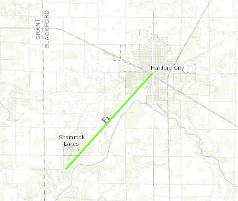 
|
||||||||||||||||
|
Tornado - Near Petroleum, Indiana
Track Map 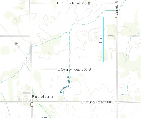
|
||||||||||||||||
|
Tornado - Berne, Indiana
Track Map 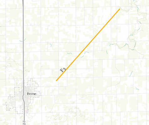
|
||||||||||||||||
|
Tornado - Van Wert, Ohio
Track Map 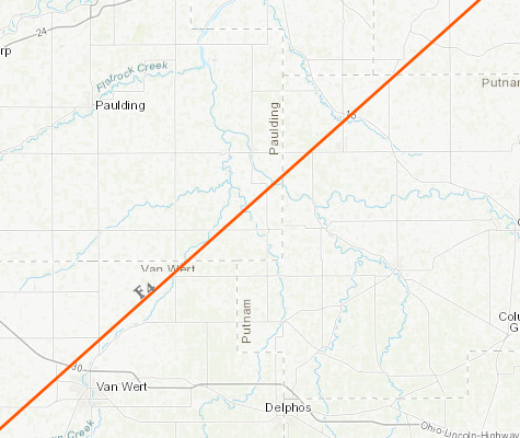
|
||||||||||||||||
The Enhanced Fujita (EF) Scale classifies tornadoes into the following categories:
| EF0 Weak 65-85 mph |
EF1 Moderate 86-110 mph |
EF2 Significant 111-135 mph |
EF3 Severe 136-165 mph |
EF4 Extreme 166-200 mph |
EF5 Catastrophic 200+ mph |
 |
|||||
Photos & Video
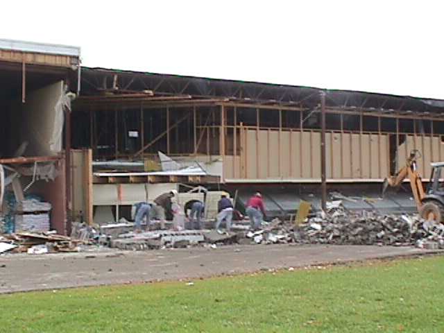
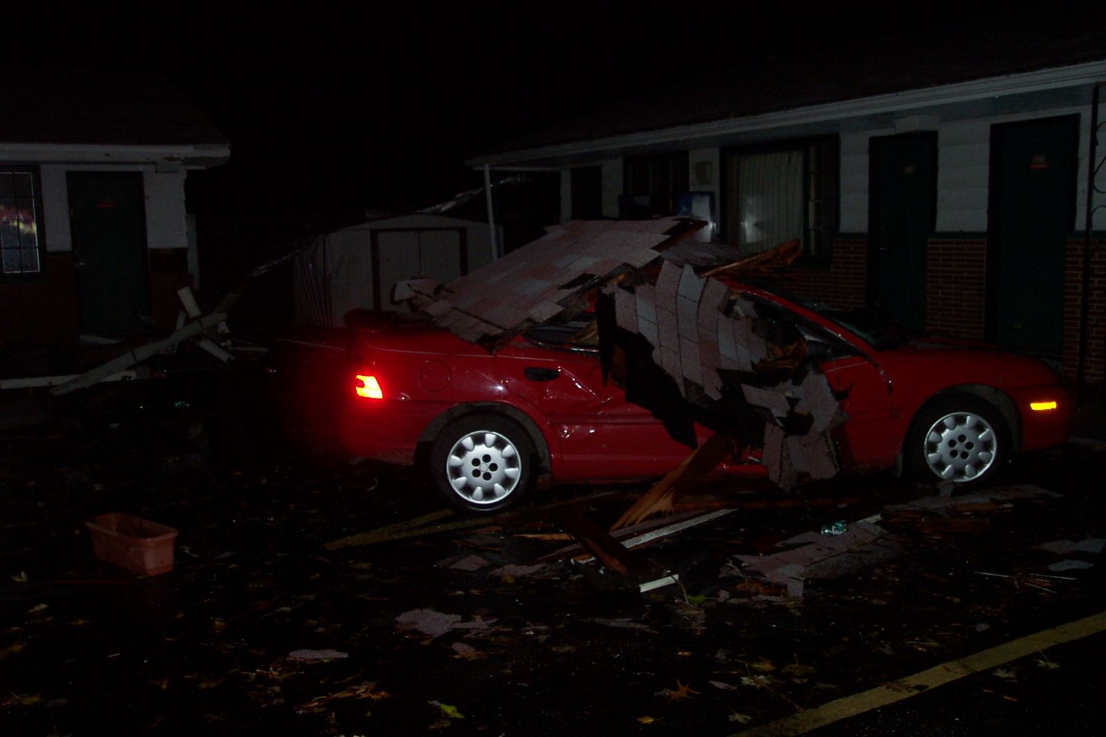
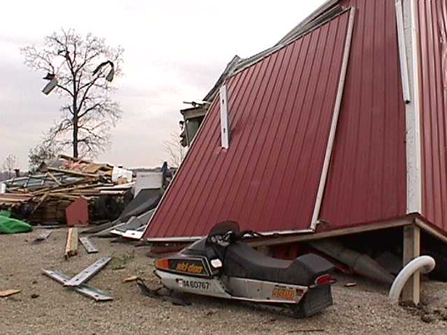
Hartford City Indiana
 |
 |
 |
| Marsh supermarket heavily damaged | Hotel and car damaged | Mobile home damaged |
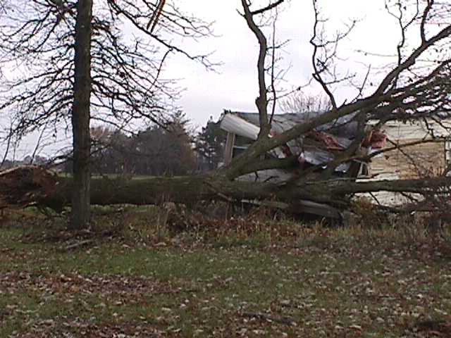
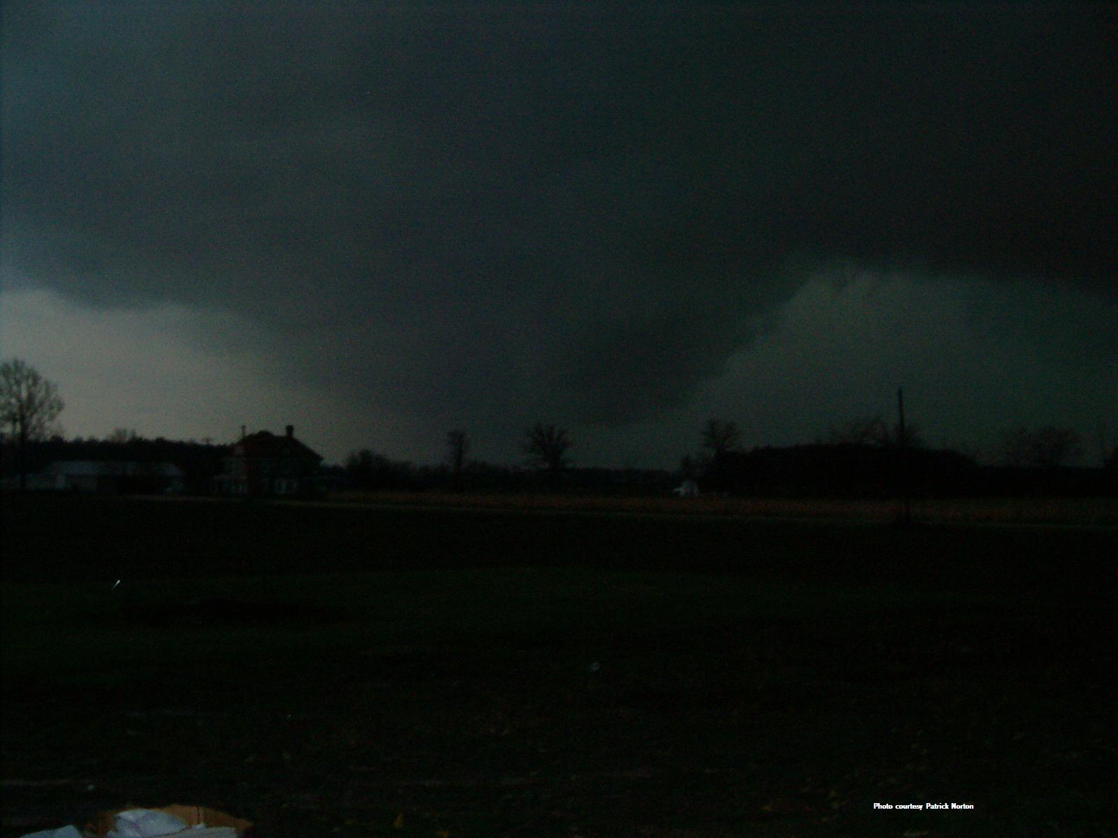
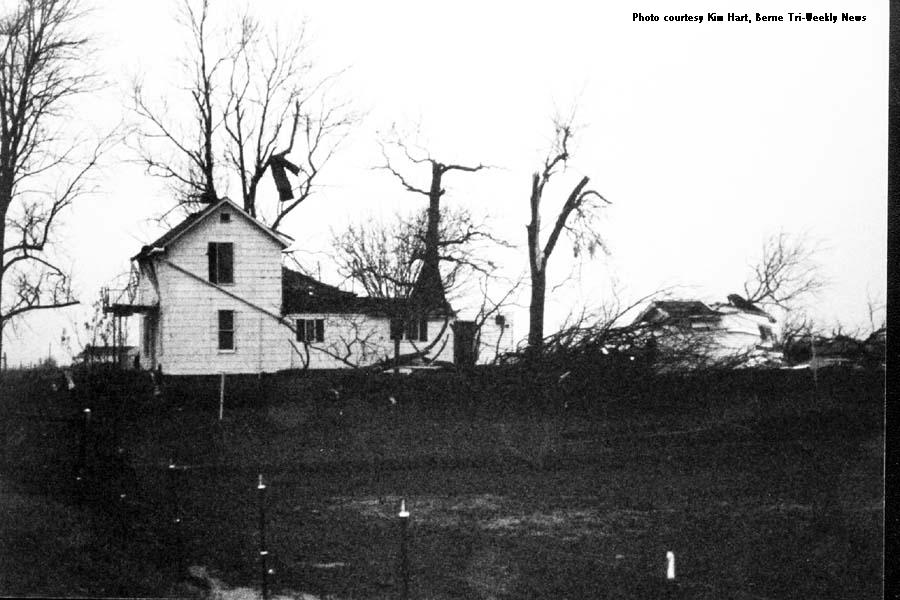
Berne Indiana
 |
 |
 |
 |
| Ominous view from Pleasant Mills (Patrick Morton) |
Barn destroyed | House damaged (Berne Tri-Weekly News) |
Twisted debris (Berne Tri-Weekly News) |
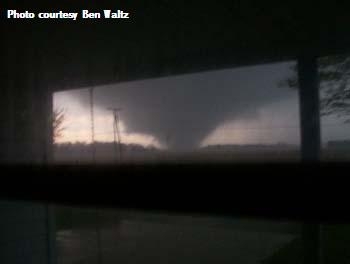
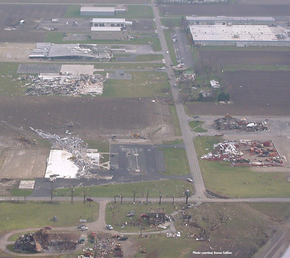
Van Wert Ohio
 |
 |
 |
 |
| Tornado bearing down on Van Wert (Ben Waltz) |
Van Wert industrial park devastated (Aaron Collins) |
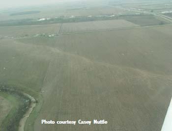
Suction vortices scour marks (Casey Nuttle) |
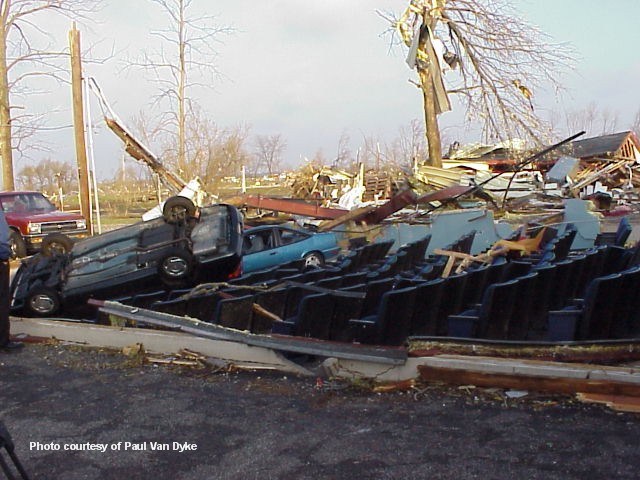
Iconic image of the Van Wert Cinema (Paul Van Dyke) |
 |
 |
 |
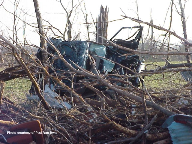 |
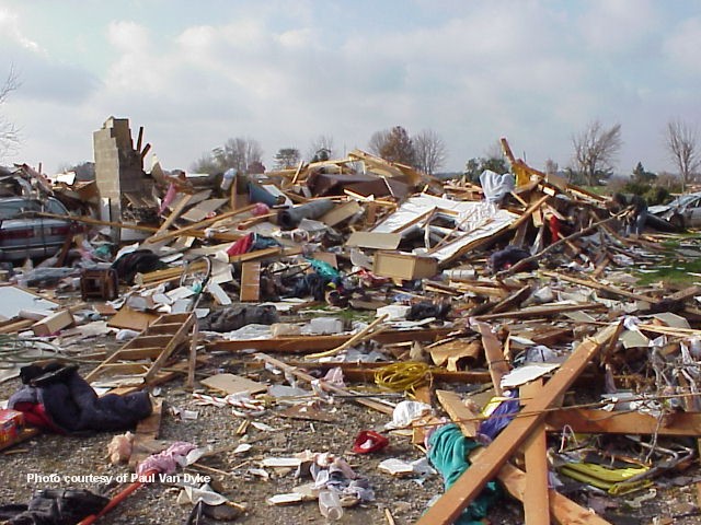
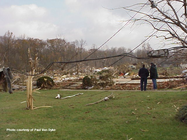
| Homes obliterated (Paul Van Dyke) |
Unimaginable damage (Paul Van Dyke) |
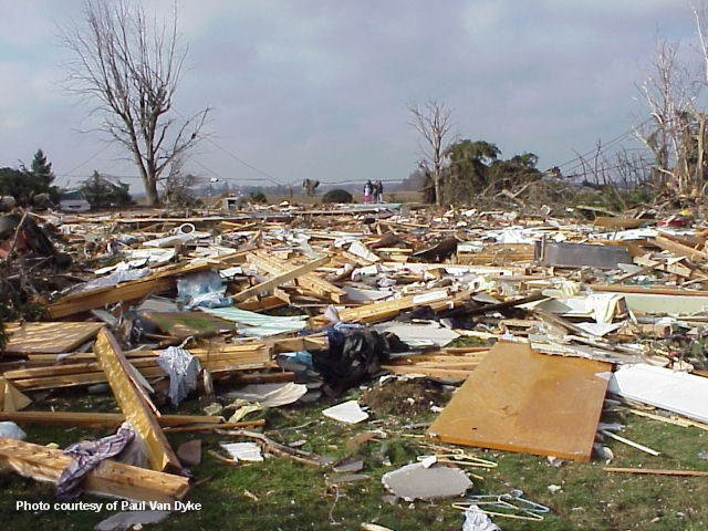
Home foundation swept clean (Paul Van Dyke) |
Mangled car impaled on a tree (Paul Van Dyke) |
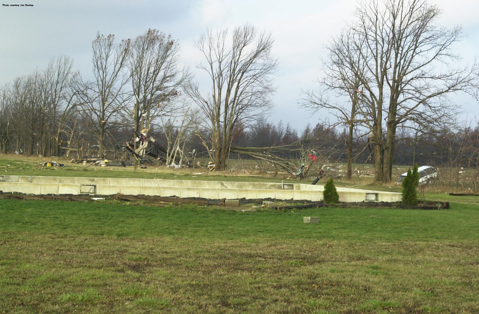
Roselms Ohio
 |
 |
 |
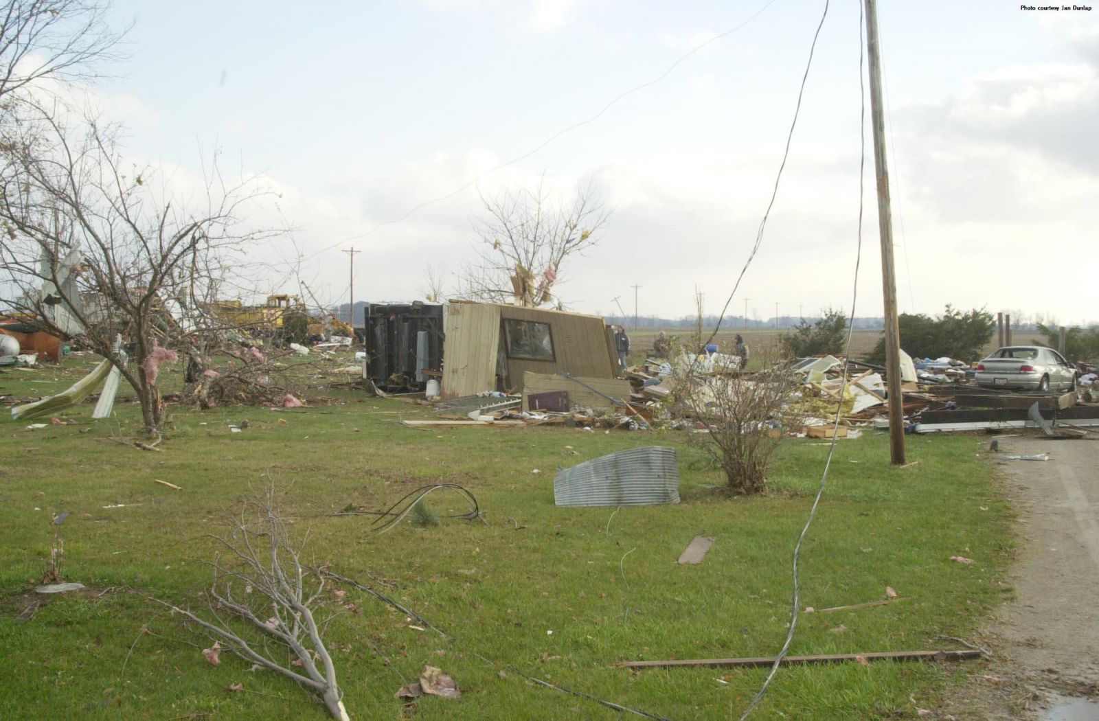 |
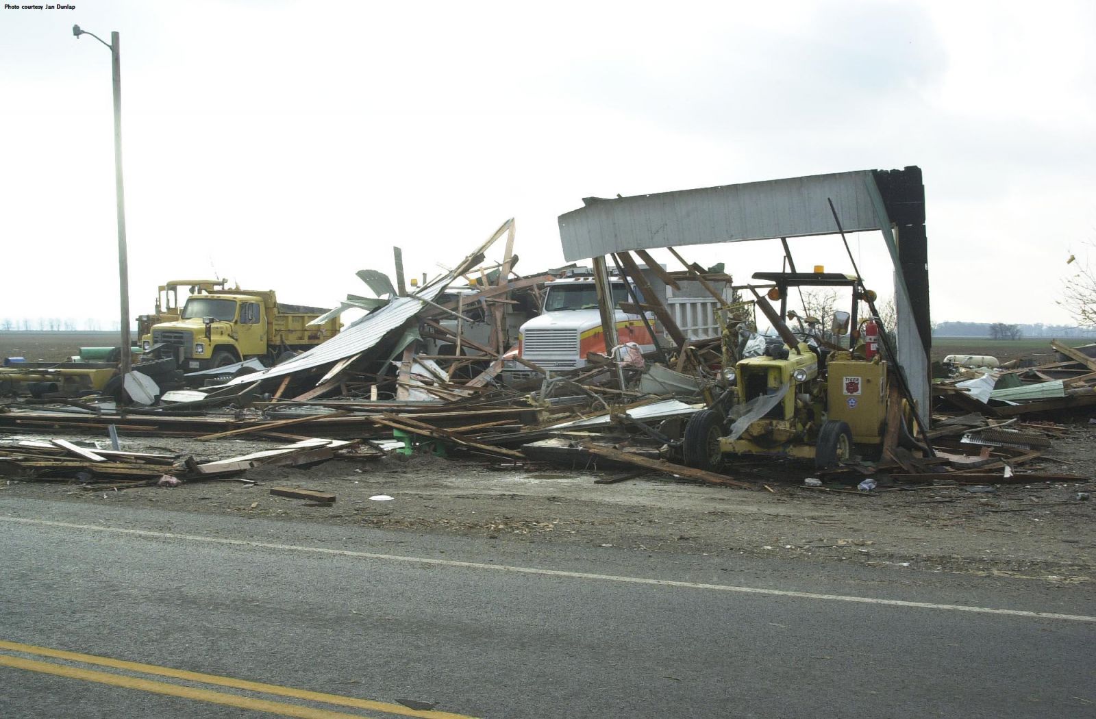
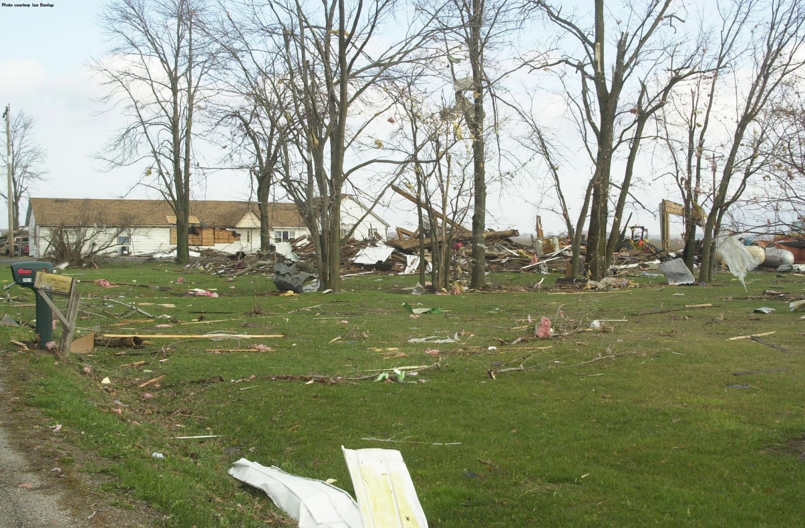
| DOT garage destroyed (Jan Dunlop) |
Farmstead heavily damaged, barn destroyed (Jan Dunlop) |
Home swept away (Jan Dunlop) |
Home destroyed (Jan Dunlop) |
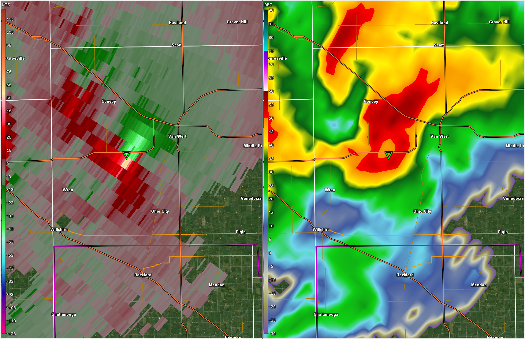
Radar
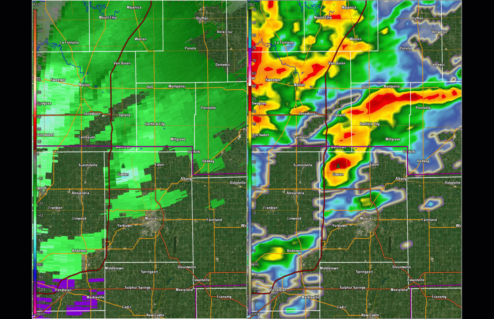 |
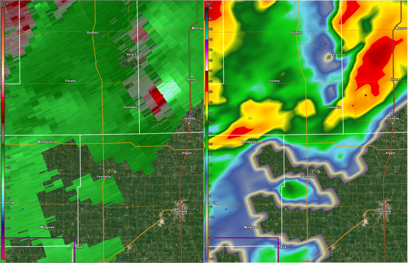 |
 |
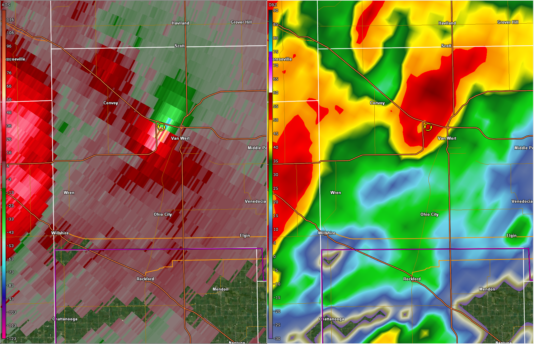 |
| 0.5 degree vel/ref feature following loop of the track of this tornadic supercell from 210 - 400 pm EST. | 0.5 degree vel/ref showing very strong rotation in this supercell approaching Van Wert Ohio | 0.5 degree vel/ref showing a very strong mesocyclone southwest of Van Wert Ohio | 0.5 degree vel/ref showing a very strong mesocyclone moving through Van Wert Ohio |
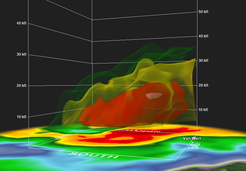
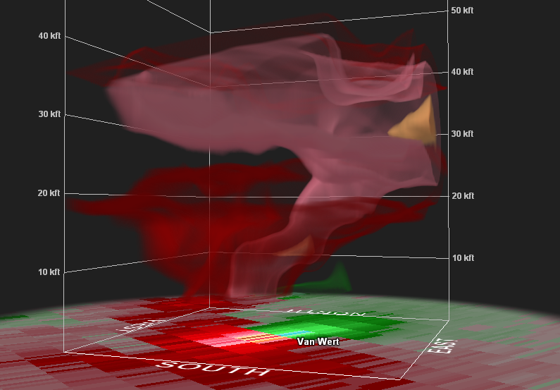 |
 |
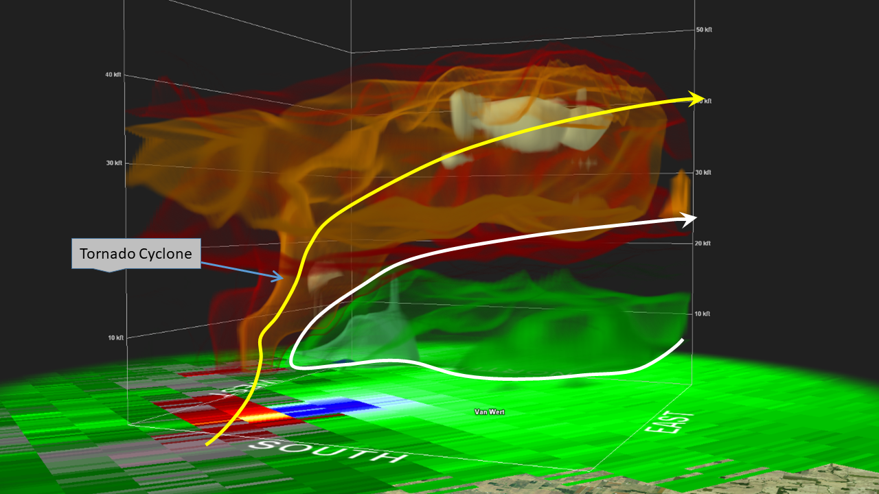 |
| 3D velocity. Pink colors denote a very strong tornado cyclone associated with this low topped supercell moving over Van Wert Ohio | 3D reflectivity. Yellow/red colors indicate a shallow, low centroid updraft in this low topped supercell moving over Van Wert Ohio | 3D storm relative velocity. White trajectory line denotes strong storm inflow within the green to aqua colors. Yellow trajectory line denotes strong flow within the updraft. Orange colors within what looks like a tube represent the intense tornado cyclone present in this tornadic supercell storm moving into Van Wert Ohio. |
Storm Reports
PRELIMINARY LOCAL STORM REPORT
NATIONAL WEATHER SERVICE NORTHERN INDIANA
1129 PM EST SUN NOV 10 2002

TIME(EST)  .....CITY LOCATION..... STATE  ...EVENT/REMARKS...
           ....COUNTY LOCATION....

0230 PM    HARTFORD CITY             IN   TORNADO
11/10/02   BLACKFORD                      DAMAGE TO MARSH GROCERY
                                          STORE.  TREE DAMAGE.
                                          REPORTED BY LAW
                                          ENFORCEMENT OFFICIAL.

0300 PM    1 N DECATUR               IN   WIND DAMAGE
11/10/02   ADAMS                          NUMEROUS TREES DOWN.
                                          REPORTED BY STORM
                                          SPOTTER.

0305 PM    5 NE BERNE                IN   TORNADO
11/10/02   ADAMS                          HOUSES AND TRAILER
                                          DESTROYED. REPORTED BY
                                          EMERGENCY MANAGEMENT.

0305 PM    6 NE BERNE                IN   TORNADO
11/10/02   ADAMS                          BARNS DESTROYED.
                                          REPORTED BY EMERGENCY
                                          MANAGEMENT.

0305 PM    2 NE BERNE                IN   TORNADO
11/10/02   ADAMS                          HOUSE DAMAGED.
                                          REPORTED BY LAW
                                          ENFORCEMENT OFFICIAL.

0317 PM    2 S UPLAND                IN   .88 INCH HAIL
11/10/02   GRANT                          REPORTED BY STORM
                                          SPOTTER.

0330 PM    VAN WERT                  OH   TORNADO
11/10/02   VAN WERT                       NUMEROUS STRUCTURES
                                          DOWN.  REPORTED BY
                                          EMERGENCY MANAGEMENT.

0340 PM    5 NE VAN WERT             OH   TORNADO
11/10/02   VAN WERT                       DAMAGED STRUCTURES.
                                          REPORTED BY HAM RADIO
                                          OPERATOR.

0345 PM    WETSEL                    OH   TORNADO
11/10/02   VAN WERT                       DAMAGED STRUCTURES.
                                          REPORTED BY HAM RADIO
                                          OPERATOR.

0353 PM    GROVER HILL               OH   TORNADO
11/10/02   PAULDING                       NUMEROUS STRUCTURES
                                          DOWN. REPORTED BY LAW
                                          ENFORCEMENT OFFICIAL.

0355 PM    2 SE GROVER HILL          OH   TORNADO
11/10/02   PAULDING                       *** 5 INJ ***
                                          HOUSE BLOWN DOWN.
                                          REPORTED BY EMERGENCY
                                          MANAGEMENT.

0355 PM    ROSELMS                   OH   TORNADO
11/10/02   PAULDING                       CHURCH LEVELED.
                                          MULTIPLE STRUCTURES
                                          DAMAGED. REPORTED BY
                                          EMERGENCY MANAGEMENT.

0400 PM    2 WNW CONTINENTAL         OH   TORNADO
11/10/02   PUTNAM                         HOMES DAMAGED. REPORTED
                                          BY HAM RADIO OPERATOR.

0400 PM    AYERSVILLE                OH   TORNADO
11/10/02   DEFIANCE                       BARN AND SILO BLOWN
                                          DOWN.  TREES DOWN.
                                          CAMPER BLOWN OVER.
                                          REPORTED BY DISPATCH.

0400 PM    3 W CONTINENTAL           OH   TORNADO
11/10/02   PUTNAM                         *** 2 DEAD, 1 INJ ***
                                          TRAILER DESTROYED.
                                          REPORTED BY EMERGENCY
                                          MANAGEMENT.

0420 PM    HOLGATE                   OH   WIND DAMAGE
11/10/02   HENRY                          TREES AND POWER LINES
                                          BLOWN DOWN COUNTYWIDE.
                                          REPORTED BY DISPATCH.

0434 PM    CAIRO                     OH   WIND DAMAGE
11/10/02   ALLEN                          TREES AND POWER LINES
                                          DOWN. REPORTED BY
                                          SHERIFF.

0440 PM    LIMA                      OH   WIND DAMAGE
11/10/02   ALLEN                          TREES AND POWER LINES
                                          BLOWN DOWN COUNTYWIDE.
                                          REPORTED BY SHERIFF.

&&
Environment
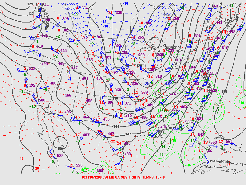
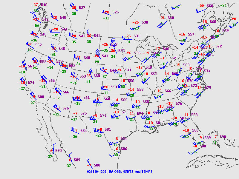
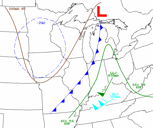
Strong zonal flow aloft undergoes significant amplification ahead of a potent disturbance ejecting out of the central plains. Deep sfc low pressure across southern Wisconsin the morning of November 10th, lifted northeast into southeast Ontario by evening as a strong cold front swept eastward across the Ohio valley. Strong southerly flow at low levels allowed for a surge of moisture, characterized by dewpoints in the 60s, to spread into the lower Great Lakes by afternoon. As a powerful mid to upper level jet, accentuated by 100kt 500 millibar flow, ejected out into a rapidly destabilizing warm sector during the afternoon, explosive thunderstorm development occurred.
 |
 |
 |
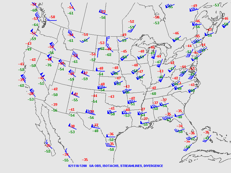 |
| Figure 1: 12Z analysis of 850mb height, wind, temp, dewpoint | Figure 2: 12Z analysis of 700mb height, wind, temp, dewpoint | Figure 3: 12Z analysis of 500mb height, wind, temp | Figure 4: 12Z analysis of 300mb wind, temp |
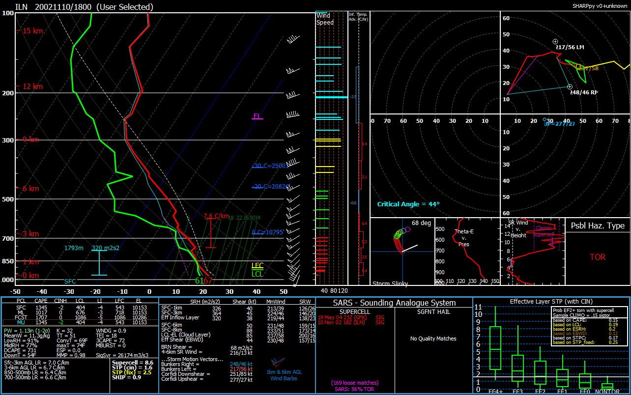
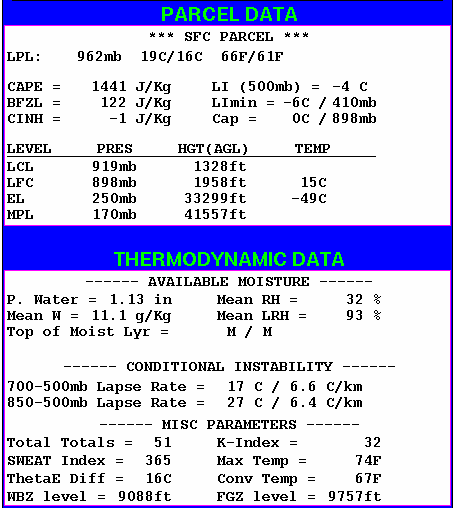
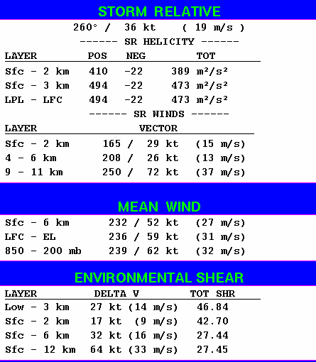
Ensuing rapid destabilization in the afternoon ahead of enlarging low level hodographs in response to intense mid level jet ejecting out across the warm sector through the Ohio valley set the stage for a regional tornado outbreak. 18Z special sounding from Wilmington Ohio shows the development of a volatile airmass by early afternoon, primed for tornadic supercells.
 |
 |
 |
 |
| Figure 5: 18Z ILN special sounding | Figure 6: 18Z ILN derived thermodynamic parameters | Figure 7: 18Z ILN derived kinematic parameters | Figure 8: 18Z Composite Chart |
Surface fronts and observation progression on November 10 2002
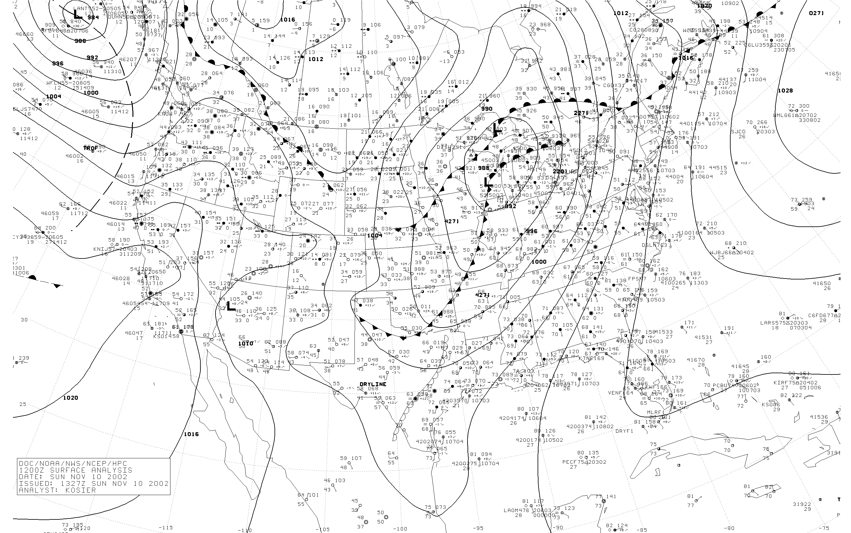 |
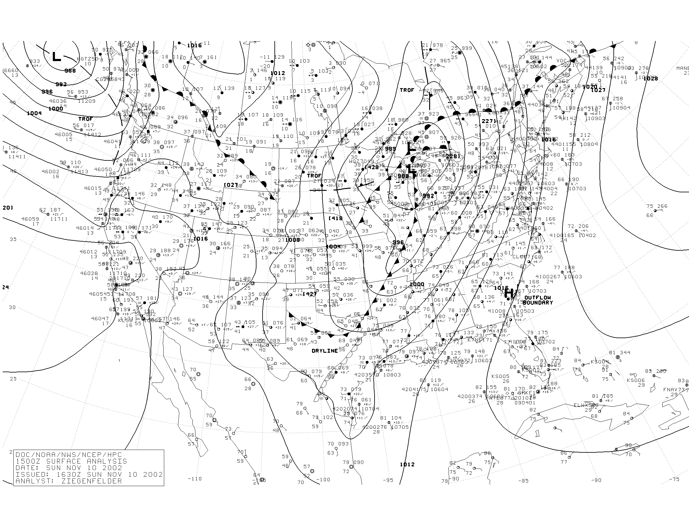 |
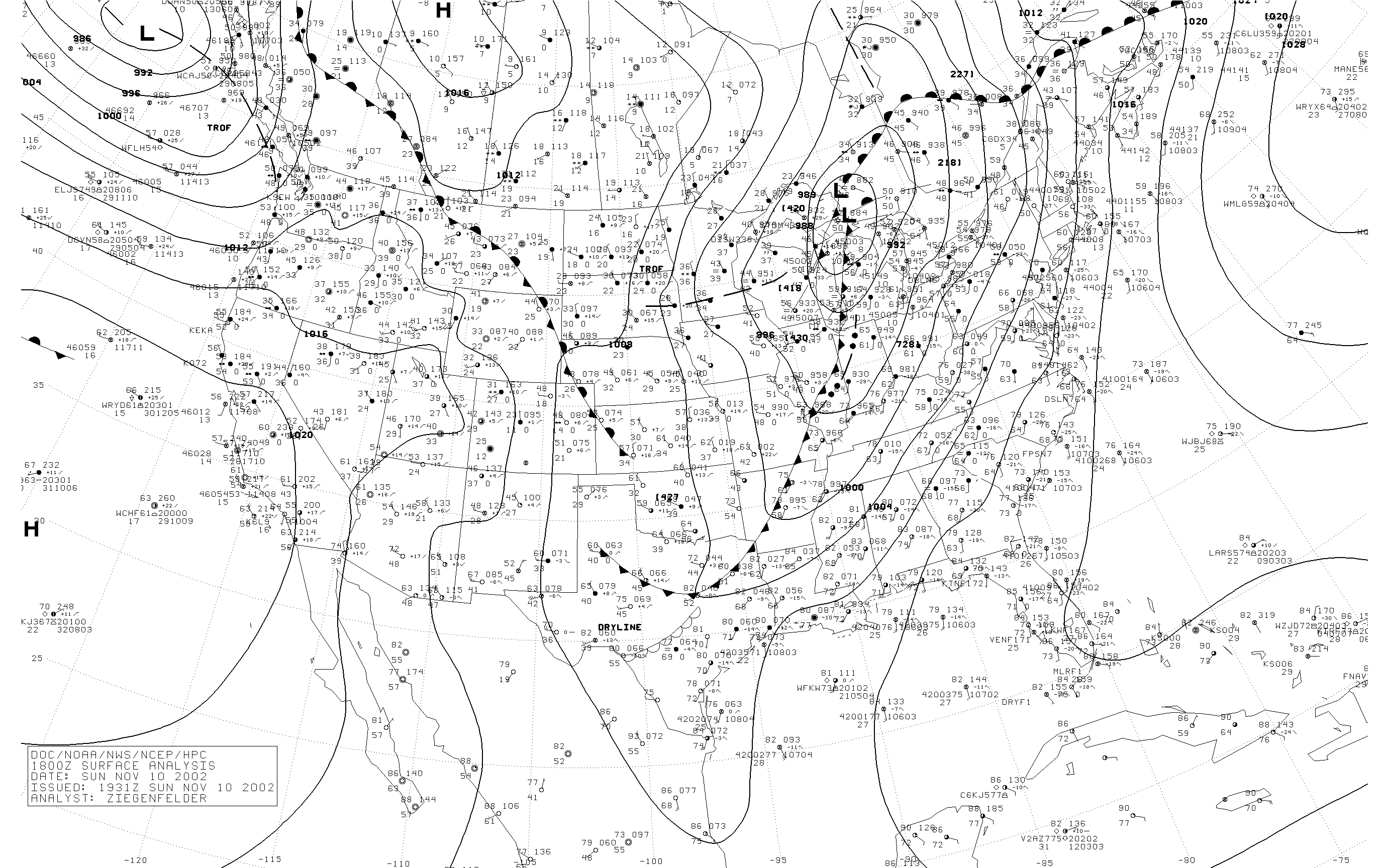 |
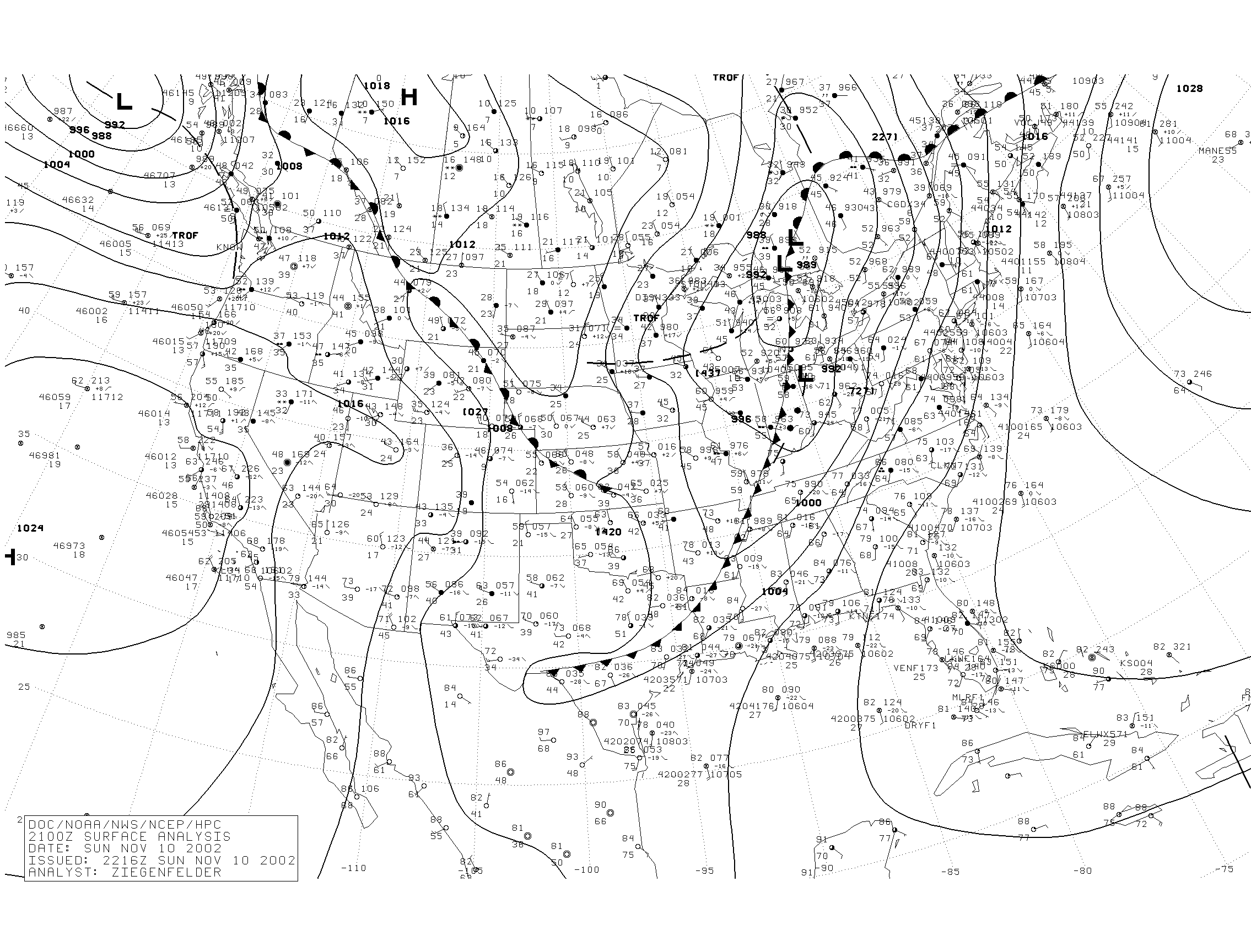 |
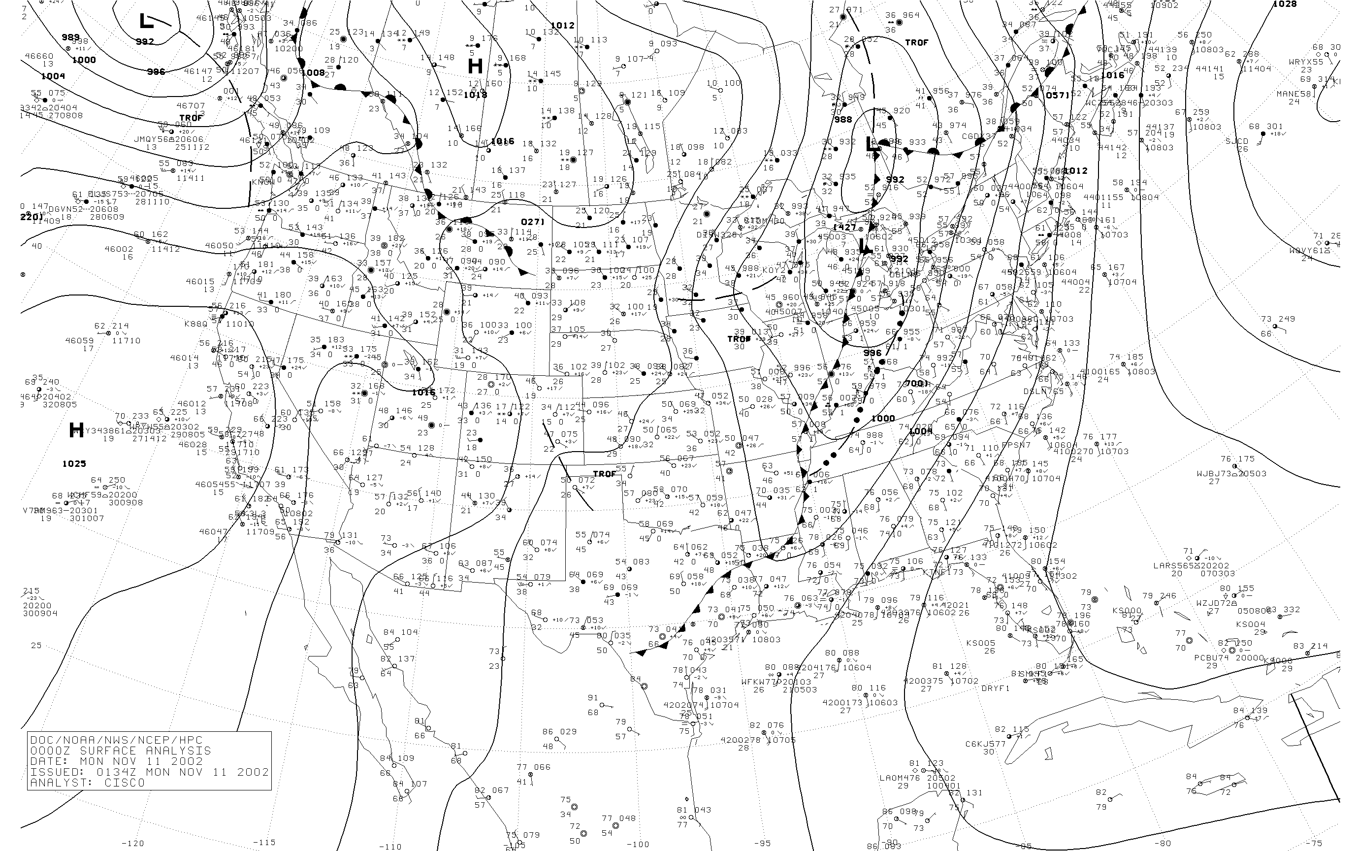 |
| Figure 9: 12Z sfc map | Figure 10: 15Z sfc map | Figure 11: 18Z sfc map | Figure 12: 21Z sfc map | Figure 13: 00Z sfc map |
 |
Media use of NWS Web News Stories is encouraged! Please acknowledge the NWS as the source of any news information accessed from this site. |
|

