Northern Indiana
Weather Forecast Office
A fast moving squall line blasted portions of northern Indiana and northwest Ohio the afternoon of June 22nd with widespread wind damage noted over a large area streching along an west-east line from Logansport Indiana to Lima Ohio.
PRELIMINARY LOCAL STORM REPORT...CORRECTED SUMMARY
NATIONAL WEATHER SERVICE NORTHERN INDIANA
1100 AM EDT FRI JUN 23 2006
..TIME.. ...EVENT... ...CITY LOCATION... ...LAT.LON...
..DATE.. ....MAG.... ..COUNTY LOCATION..ST.. ...SOURCE....
..REMARKS..
1250 AM TSTM WND DMG LOGANSPORT 40.75N 86.36W
06/22/2006 CASS IN LAW ENFORCEMENT
LARGE TREES DOWN.
1220 PM TSTM WND DMG 1 SW MONTICELLO 40.74N 86.78W
06/22/2006 WHITE IN LAW ENFORCEMENT
SEVERAL TREES DOWN AROUND MONTICELLO.
0102 PM TSTM WND DMG 3 SW LOGANSPORT 40.72N 86.40W
06/22/2006 CASS IN EMERGENCY MNGR
5 HOMES WITH TREES BLEW OVER ON THEM AND STRUCTURAL
DAMAGE.
0102 PM TSTM WND DMG LOGANSPORT 40.75N 86.36W
06/22/2006 CASS IN EMERGENCY MNGR
APPROXIMATELY A DOZEN HOMES IN THE SOUTHEAST CASS AREA
WITH TREES BLEW ON THEM AND STRUCTURAL DAMAGE.
0102 PM TSTM WND DMG LOGANSPORT 40.75N 86.36W
06/22/2006 CASS IN EMERGENCY MNGR
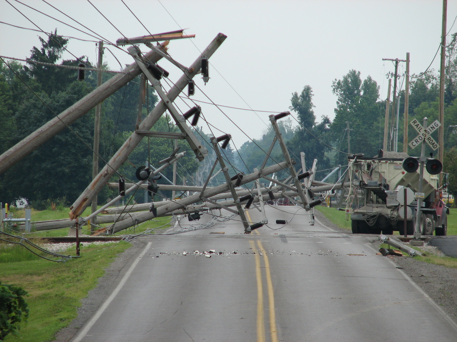
POWERLINES AND POWER POLES DOWN. WIDESPREAD POWER
OUTAGES IN SOUTHEAST CASS.
0112 PM HAIL 1 S LOGANSPORT 40.74N 86.36W
06/22/2006 M0.75 INCH CASS IN EMERGENCY MNGR
0114 PM TSTM WND DMG 2 SE WALTON 40.64N 86.22W
06/22/2006 CASS IN EMERGENCY MNGR
0114 PM TSTM WND DMG 2 SE WALTON 40.64N 86.22W
06/22/2006 CASS IN EMERGENCY MNGR
NUMEROUS LARGE TREES DOWN IN THE GALVESTON AREA.
0117 PM TSTM WND DMG BUNKER HILL 40.66N 86.10W
06/22/2006 MIAMI IN LAW ENFORCEMENT
STATE TROOPER HAD CAR WINDOW BROKEN OUT BY AIRBORNE
UPROOTED SIGN.
0117 PM TSTM WND DMG 9 SSW PERU 40.63N 86.13W
06/22/2006 MIAMI IN TRAINED SPOTTER
MOBILE HOME DAMAGE WITH TREES AND POWER LINES DOWN.
0120 PM TSTM WND DMG PERU 40.75N 86.07W
06/22/2006 MIAMI IN TRAINED SPOTTER
NUMEROUS TREES AND POWERLINES DOWN.
0125 PM TSTM WND DMG 1 SSW BUNKER HILL 40.65N 86.11W
06/22/2006 MIAMI IN TRAINED SPOTTER
TRACTOR TRAILER BLEW OFF ROAD ON 31
0127 PM HAIL 2 WSW PERU 40.74N 86.10W
06/22/2006 M1.00 INCH MIAMI IN TRAINED SPOTTER
SEVERAL HOMES IN WILLOW CREEK SUBDIVISION HAVE DAMAGE
0130 PM HAIL 2 WSW PERU 40.74N 86.10W
06/22/2006 M1.00 INCH MIAMI IN TRAINED SPOTTER
SEVERAL HOMES IN WILLOW CREEK SUBDIVISION HAVE HAIL
DAMAGE
0135 PM TSTM WND GST BUNKER HILL 40.66N 86.10W
06/22/2006 M70 MPH MIAMI IN AMATEUR RADIO
PENNY SIZE HAIL
0140 PM HAIL PERU 40.75N 86.07W
06/22/2006 M1.00 INCH MIAMI IN EMERGENCY MNGR
DOWNTOWN ALSO DIME SIZE HAIL 1 N
0150 PM TSTM WND GST HUNTINGTON 40.88N 85.51W
06/22/2006 E70 MPH HUNTINGTON IN TRAINED SPOTTER
0157 PM TSTM WND DMG 8 SE WABASH 40.72N 85.72W
06/22/2006 WABASH IN LAW ENFORCEMENT
TREE BLOWN DOWN.
0200 PM TSTM WND DMG MARION 40.55N 85.67W
06/22/2006 GRANT IN SPOTTER
PART OF GRANT COUNTY COURTHOUSE ROOF BLEW OFF.
0200 PM TSTM WND DMG MARION 40.55N 85.67W
06/22/2006 GRANT IN EMERGENCY MNGR
SEVERAL POWER LINES DOWN IN THE AREA.
0202 PM TSTM WND DMG MARION 40.55N 85.67W
06/22/2006 GRANT IN NWS EMPLOYEE
TREES DOWN WITH SOME OVER POWER LINES.
0206 PM HAIL HUNTINGTON 40.88N 85.51W
06/22/2006 M1.00 INCH HUNTINGTON IN EMERGENCY MNGR
HAIL REPORTED IN HUNTINGTON.
0206 PM TSTM WND DMG 4 W WARREN 40.69N 85.50W
06/22/2006 HUNTINGTON IN AMATEUR RADIO
6 SEMIS BLOWN OVER
0211 PM HAIL 2 N WARREN 40.72N 85.42W
06/22/2006 M1.00 INCH HUNTINGTON IN TRAINED SPOTTER
2 MI. NORTH OF WARREN, INTERSECTION OF I69 AND INDIANA
5.
0215 PM TSTM WND DMG 10 SW BLUFFTON 40.64N 85.31W
06/22/2006 WELLS IN NWS EMPLOYEE
TREES, POWERLINES AND LIMBS DOWN CITYWIDE
0215 PM TSTM WND DMG FORT WAYNE 41.07N 85.14W
06/22/2006 ALLEN IN BROADCAST MEDIA
TREES AND POWERLINES DOWN
0219 PM TSTM WND GST 7 SW BLUFFTON 40.67N 85.27W
06/22/2006 E80 MPH WELLS IN SPOTTER
TREES BROKEN OFF AND BENTER OVER AROUND LIBERTY CENTER.
0229 PM HAIL ANTWERP 41.18N 84.74W
06/22/2006 M0.75 INCH PAULDING OH EMERGENCY MNGR
0230 PM TSTM WND DMG 1 S MONROE 40.73N 84.94W
06/22/2006 ADAMS IN TRAINED SPOTTER
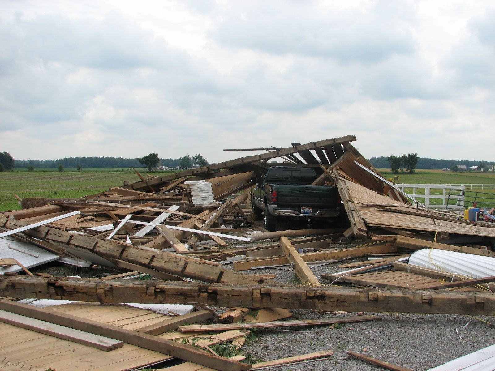
100-200 YARD WIDE DAMAGE PATH WITH MULTIPLE TREES DOWN
UP TO 20" DIAMETER AND BARN ROOFS BLOWN OFF.
0235 PM TSTM WND DMG PORTLAND 40.43N 84.98W
06/22/2006 JAY IN TRAINED SPOTTER
TREES UPROOTED AND LIMBS BLOWN DOWN.
0238 PM TORNADO 2 E WILLSHIRE 40.75N 84.75W
06/22/2006 VAN WERT OH NWS STORM SURVEY
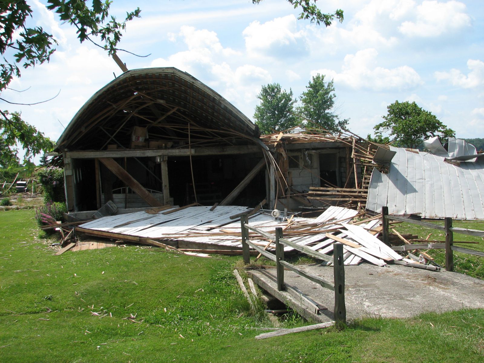
F0 TORNADO. BARNS DAMAGED WITH DEBRIS CARRIED ACROSS
AN ADJACENT FIELD.
0240 PM TSTM WND DMG WILLSHIRE 40.75N 84.79W
06/22/2006 VAN WERT OH EMERGENCY MNGR
ALL STREETS IN TOWN CLOSED DUE TO DOWNED TREES AND
POWERLINES.
0242 PM TSTM WND DMG 5 E MONROE 40.74N 84.84W
06/22/2006 ADAMS IN TRAINED SPOTTER
TREE SNAPPED OFF 18" DIAMETER
0242 PM TSTM WND DMG 5 E MONROE 40.74N 84.84W
06/22/2006 ADAMS IN TRAINED SPOTTER
18" TREE IN DIAMETER SNAPPED OFF
0243 PM TORNADO 5 E WILLSHIRE OH 40.75N 84.70W
06/22/2006 VAN WERT NWS STORM SURVEY
0245 PM TSTM WND DMG VAN WERT 40.86N 84.58W
06/22/2006 VAN WERT OH EMERGENCY MNGR
SEVERAL TREE AND POWER LINES DOWN AND BARN WAS BLEW
OVER.
0247 PM FUNNEL CLOUD VAN WERT 40.86N 84.58W
06/22/2006 VAN WERT OH EMERGENCY MNGR
0250 PM TSTM WND GST 5 S CONVOY 40.84N 84.71W
06/22/2006 E80 MPH VAN WERT OH TRAINED SPOTTER
0258 PM TORNADO 4 SW DELPHOS 40.80N 84.39W
06/22/2006 VAN WERT NWS STORM SURVEY
F0 TORNADO. DESTROYED A WELL BUILT SHED.
0305 PM TSTM WND DMG KALIDA 40.99N 84.20W
06/22/2006 PUTNAM OH EMERGENCY MNGR
SEVERAL LARGE TREES DOWN.
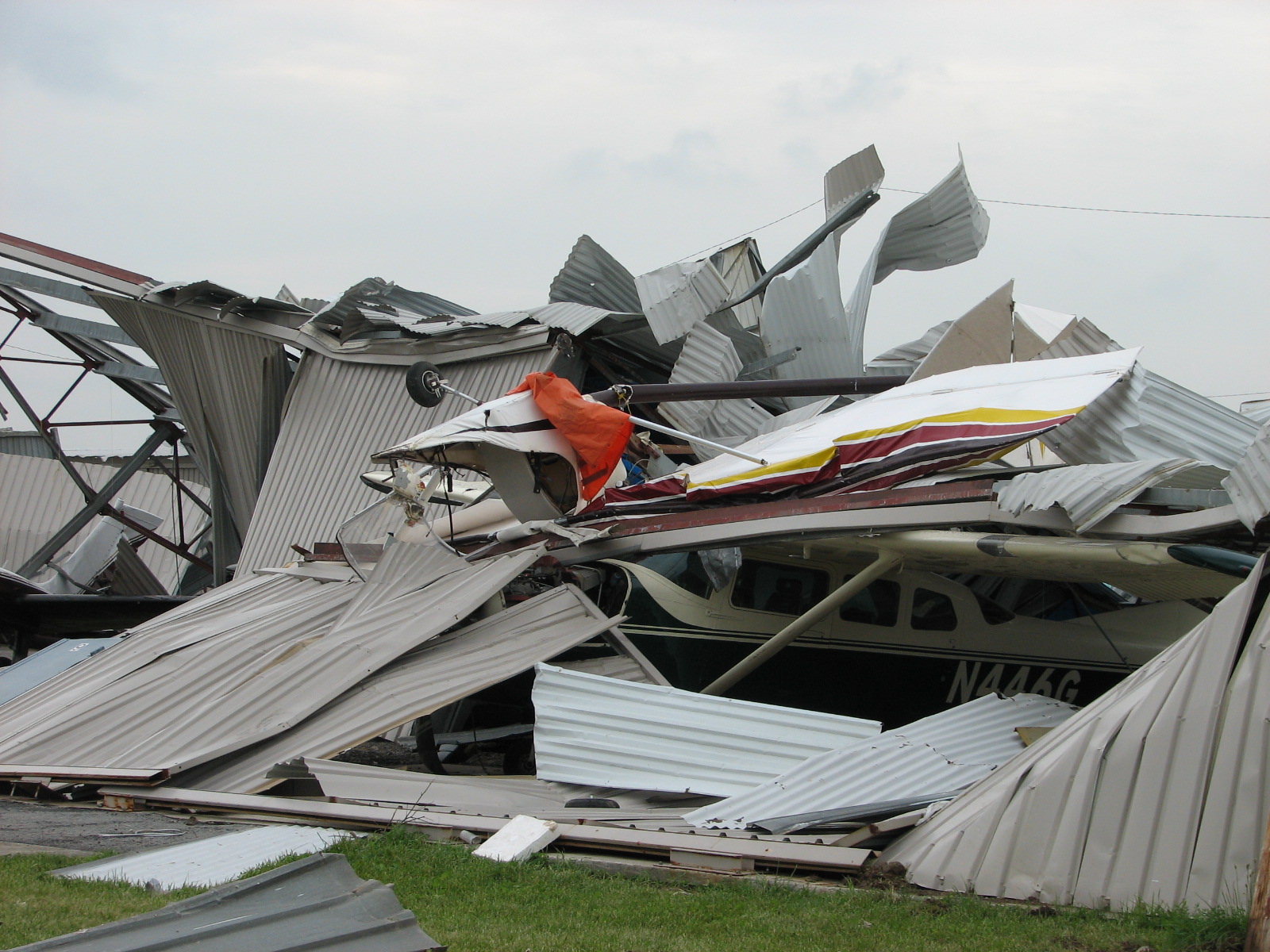
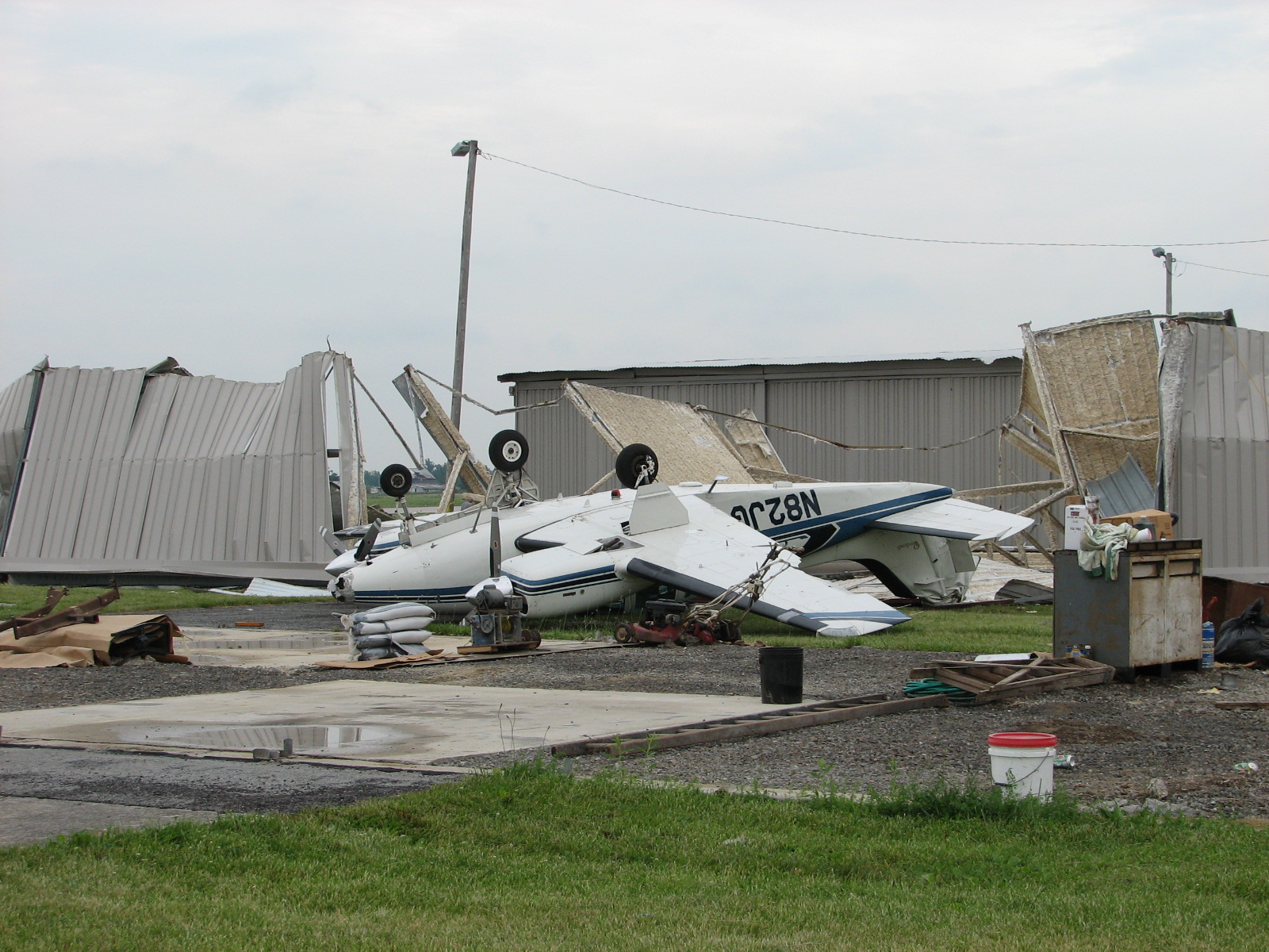
0315 PM TSTM WND DMG 1 E LIMA 40.74N 84.09W
06/22/2006 ALLEN OH EMERGENCY MANAGER
SEVERAL AIRCRAFT DAMAGED TWO BUILDINGS DESTROYED AND 2/3
OF COUNTY WITHOUT POWER
0315 PM TSTM WND DMG LIMA 40.74N 84.11W
06/22/2006 ALLEN OH AMATEUR RADIO
ROOF OF MOTEL 6 COLLAPSED.
0318 PM TORNADO 3 E BEAVERDAM 40.83N 83.92W
06/22/2006 ALLEN OH NWS STORM SURVEY
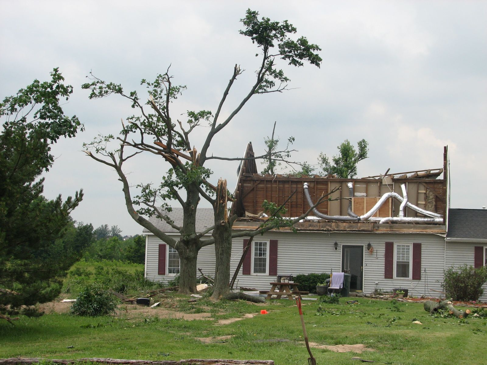
F1 TORNADO. 50 YARDS WIDE AND 200 YARDS LONG. DESTROYED
ROOF ON ONE HOME AND DAMAGED ROOF ON ANOTHER HOME.
0320 PM TSTM WND DMG PANDORA 40.95N 83.96W
06/22/2006 PUTNAM OH EMERGENCY MNGR
TREES AND POWER LINES DOWN.
0322 PM TSTM WND DMG LIMA 40.74N 84.11W
06/22/2006 ALLEN OH AMATEUR RADIO
TREES AND POWER LINES DOWN AND ROOF DAMAGE TO A SHOPPING
CENTER.
0323 PM TORNADO 3 E LIMA 40.74N 84.05W
06/22/2006 ALLEN OH AMATEUR RADIO
LAW ENFORCEMENT REPORTED POSSIBLE TOUCH DOWN.
$$
NWSFO NORTHERN INDIANA
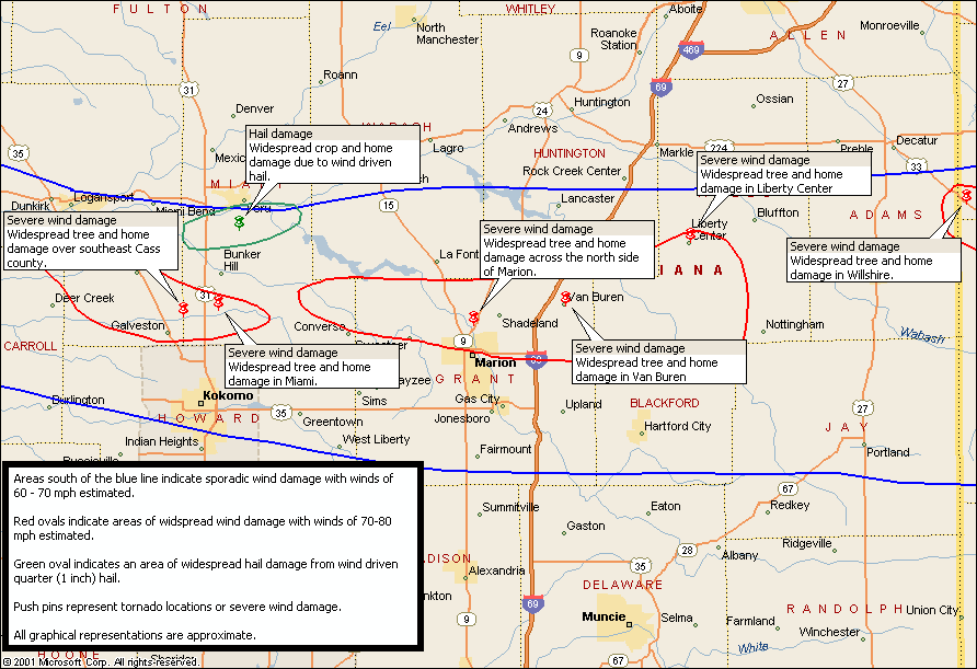
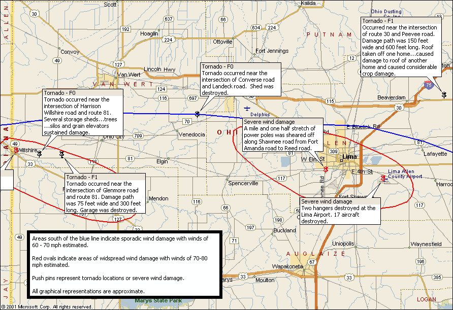
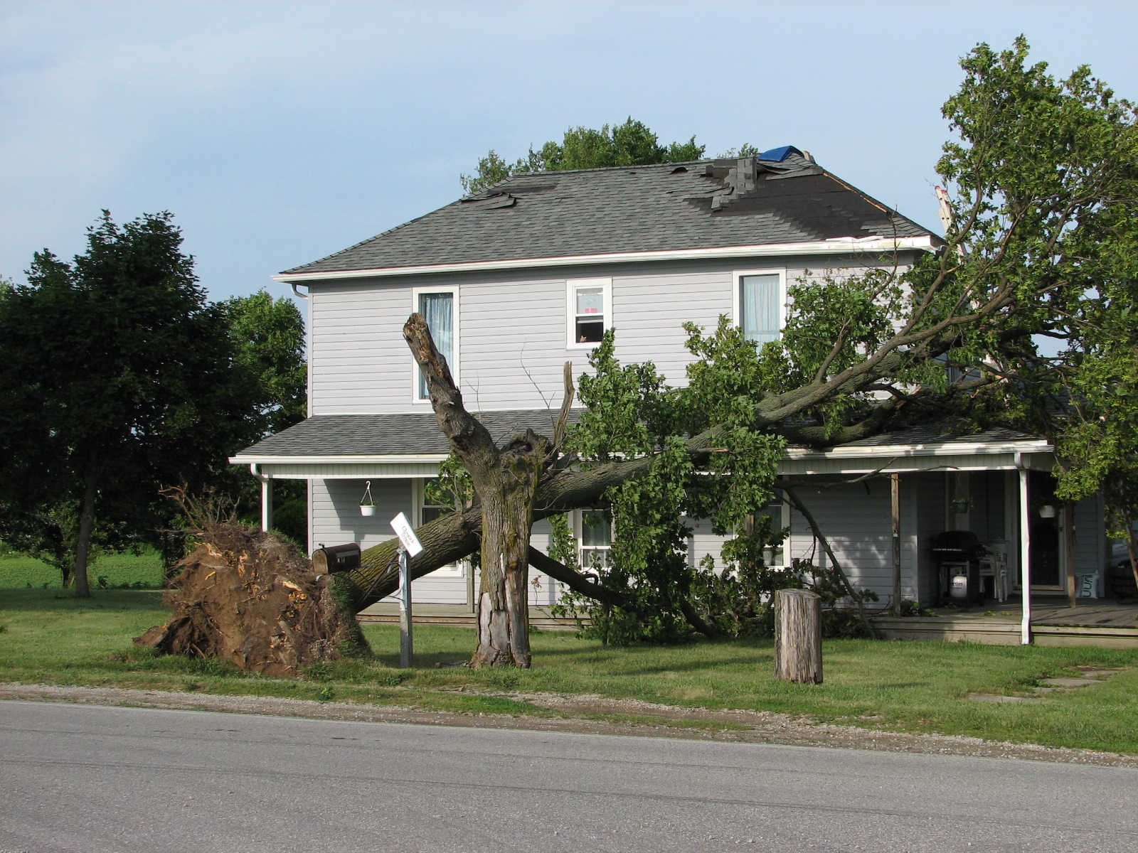
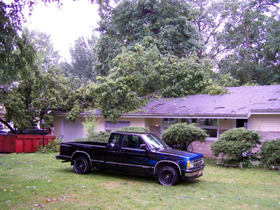
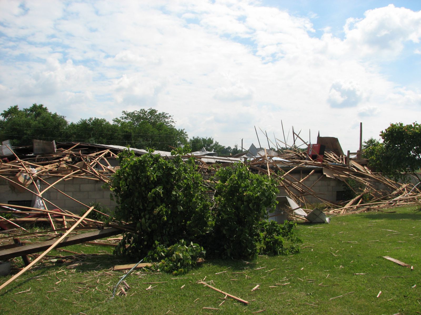
Peak winds up to 85 mph within the macroburst area were estimated to have occurred with widespread damage to trees, crops and homes. Particularly hard hit areas included southeast Cass county, the towns of Miami, Marion, Van Buren, Liberty Center, Willshire and Lima. In addition, several weak, brief tornadoes occurred in Van Wert and Allen counties.
PUBLIC INFORMATION STATEMENT...CORRECTION
NATIONAL WEATHER SERVICE NORTHERN INDIANA
600 PM EDT FRI JUN 23 2006

...SEVERAL TORNADO TOUCHDOWNS WERE CONFIRMED IN NORTHWEST OHIO...

ALTHOUGH THE BULK OF THE DAMAGE FROM THURSDAY AFTERNOON`S STORM WAS
CAUSED BY STRAIGHT LINE WINDS ASSOCIATED WITH OUTFLOW FROM A LINE OF
THUNDERSTORMS... A NATIONAL WEATHER SERVICE DAMAGE SURVEY TEAM HAS
DETERMINED THAT SEVERAL WEAK TORNADOES ALSO OCCURRED.

AN F0 TORNADO WITH WINDS UP TO 72 MPH OCCURRED 2 MILES EAST OF
WILLSHIRE IN SOUTHWEST VAN WERT COUNTY NEAR THE INTERSECTION OF
HARRISON WILLSHIRE ROAD AND ROUTE 81. A BARN WAS DAMAGED IN THIS
AREA WITH DEBRIS CARRIED ACROSS AN ADJACENT FIELD.

AN F1 TORNADO WITH WINDS OF 73 TO 112 MPH OCCURRED 5 MILES EAST OF
THE TOWN OF WILLSHIRE IN SOUTHWEST VAN WERT COUNTY... NEAR THE
INTERSECTION OF ROUTE 81 AND GLENMORE ROAD. THE DAMAGE PATH FROM
THIS TORNADO WAS 25 YARDS WIDE AND 100 YARDS LONG. THE MOST NOTABLE
DAMAGE IN THIS AREA WAS TO A GARAGE WHICH WAS BUILT INTO A HILLSIDE.
SOME BLOCKS OF THE FOUNDATION WERE DISLODGED AS THE WALLS OF THE
GARAGE BLEW DOWN.

AN F0 TORNADO WITH WINDS UP TO 72 MPH OCCURRED 4 MILES SOUTHWEST OF
DELPHOS IN EASTERN VAN WERT COUNTY NEAR THE INTERSECTION OF CONVERSE
ROAD AND LANDECK ROAD. A WELL BUILT SHED WAS DESTROYED IN THIS AREA.

AN F1 TORNADO WITH WINDS OF 73 TO 112 MPH OCCURRED ABOUT 3 MILES
EAST OF THE TOWN OF BEAVERDAM IN NORTHEAST ALLEN COUNTY OHIO NEAR
THE INTERSECTION OF ROUTE 30 AND PEEVEE ROAD.  THE TORNADO WAS ON
THE GROUND FOR 200 YARDS AND WAS 50 YARDS WIDE. THE TORNADO
DESTROYED THE ROOF ON ONE HOME... CAUSED DAMAGE TO THE ROOF OF
ANOTHER HOME... AND CAUSED CROP DAMAGE.

THIS IS YET ANOTHER EXAMPLE OF STRAIGHT LINE THUNDERSTORM WINDS
PRODUCING FAR MORE SIGNIFICANT, AND MUCH MORE WIDESPREAD DAMAGE
THAN THE WEAK TORNADOES WHICH WERE ASSOCIATED WITH THIS EVENT.

$$

NWSFO NORTHERN INDIANA
Damage maps, including some pictures of the damage, are shown below.
 |
 |
 |
 |
 |
 |
 |
 |
 |
 |
 |
06/24/2006 TH
Hazards
Heat Related
Winter Related
Watch/Warning
Outlook
Storm Reports
Storm Prediction Center
Submit a Report
Event Ready
Climate
FWA Daily
SBN Daily
FWA Monthly
SBN Monthly
CoCoRaHS
Spring Frost Climatology
Fall Frost Climatology
Severe Climatology
Local Information
Skywarn
COOP
Our Office
WSR-88D
Headline Criteria
NOAA Weather Radio
Weather History
Probabilistic Snowfall
Public Information Statement
Social Media Feeds
Weather Events Page
US Dept of Commerce
National Oceanic and Atmospheric Administration
National Weather Service
Northern Indiana
7506 E 850 N
Syracuse, IN 46567
574-834-1104
Comments? Questions? Please Contact Us.

