Northern Indiana
Weather Forecast Office
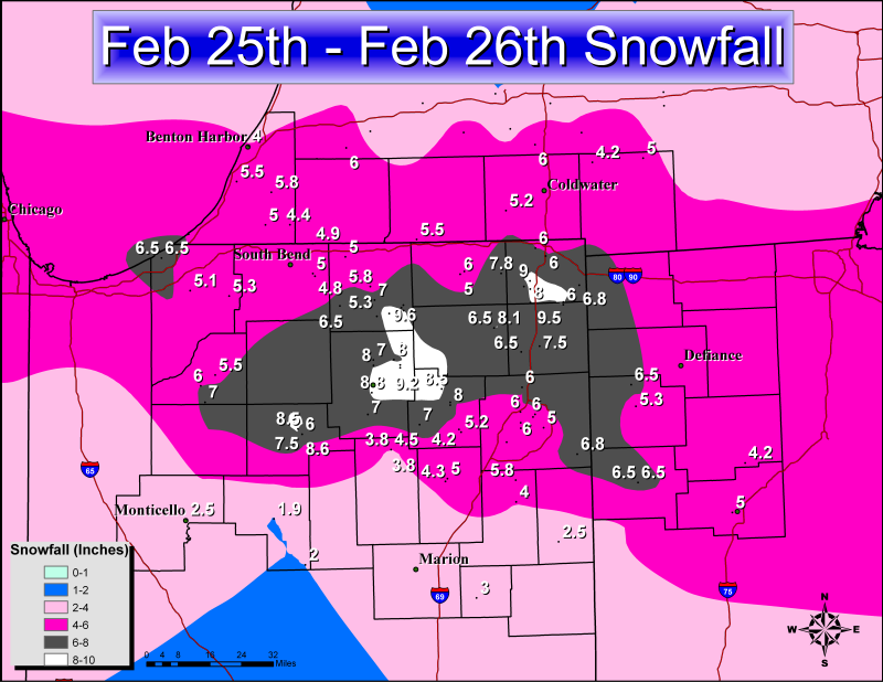
Heavy snow fell over the area Monday night and Tuesday morning as a strong area of low pressure moved up the Ohio Valley. A Winter Storm Watch was issued by the National Weather Service in Northern Indiana for this event over a day in advance and was upgraded to a Winter Storm Warning several hours before the event. 4-8 inches of snowfall was forecast with locally higher amounts possible. A band of heavy snow set up along a Knox to Warsaw to Auburn line dropping 6-8 inches with a few reports of over 9 inches of snow. A map of snow amounts can be seen below.
PUBLIC INFORMATION STATEMENT
NATIONAL WEATHER SERVICE NORTHERN INDIANA
536 PM EST TUE FEB 26 2008

...PRELIMINARY SNOWFALL TOTALS...

PRELIMINARY SNOWFALL TOTALS FOR FEBRUARY 25-26 ARE LISTED
BELOW.

LOCATION                      SNOWFALL    COMMENTS
                               IN/S/

CULVER IN                      11.5       02/26/08 1030 AM
WARSAW IN                      10.0       02/26/08 0700 AM
MICHIGAN CITY IN               10.0       02/26/08 0443 PM
3 E NEW PARIS IN                9.6       02/26/08 0900 AM
HAMILTON IN                     9.5       02/26/08 0140 PM
1 E WARSAW IN                   9.4       02/26/08 1043 AM
2 SW NORTH WEBSTER IN           9.2       02/26/08 1150 AM
5 N HUDSON IN                   9.0       02/26/08 0900 AM
ROCHESTER IN                    8.6       02/26/08 0900 AM
3 SE SYRACUSE IN                8.5       02/26/08 0700 AM
2 W TRI-LAKES IN                8.5       02/26/08 1233 PM
2 NW ROCHESTER IN               8.5       02/26/08 0900 AM
6 SW ANGOLA IN                  8.4       02/26/08 1114 AM
1 SSW MILLERSBURG IN            8.2       02/26/08 0700 AM
KENDALLVILLE IN                 8.1       02/26/08 1100 AM
HUDSON IN                       8.0       02/26/08 0915 AM
COLUMBIA CITY IN                8.0       02/26/08 0800 AM
5 N WARSAW IN                   8.0       02/26/08 0750 AM
5 E LEESBURG IN                 8.0       02/26/08 0700 AM
2 SSW WARSAW IN                 8.0       02/26/08 0915 AM
7 SSW ORLAND IN                 7.8       02/26/08 0900 AM
MILLERSBURG IN                  7.5       02/26/08 0800 AM
1 SW MILLERSBURG IN             7.5       02/26/08 0700 AM
1 NE AUBURN IN                  7.5       02/26/08 0700 AM
1 SSW NEW PARIS IN              7.1       02/26/08 0700 AM
SOUTH WHITLEY IN                7.0       02/26/08 1202 PM
LEESBURG IN                     7.0       02/26/08 0700 AM
CLAYPOOL IN                     7.0       02/26/08 0700 AM
6 ESE NORTH JUDSON IN           7.0       02/26/08 0700 AM
2 S GOSHEN IN                   7.0       02/26/08 0700 AM
MONROEVILLE IN                  6.8       02/26/08 1107 AM
9 ESE ANGOLA IN                 6.8       02/26/08 0700 AM
WAKARUSA IN                     6.5       02/26/08 0700 AM
VAN WERT OH                     6.5       02/26/08 1249 PM
GARRETT IN                      6.5       02/26/08 0800 AM
CECIL OH                        6.5       02/26/08 0800 AM
LAGRANGE IN                     6.0       02/26/08 0851 AM
6 W FREMONT IN                  6.0       02/26/08 0700 AM
5 SW KNOX IN                    6.0       02/26/08 0700 AM
4 N ANGOLA IN                   6.0       02/26/08 0639 AM
2 ESE HUNTERTOWN IN             6.0       02/26/08 0700 AM
1 S HAMILTON IN                 6.0       02/26/08 0140 PM
1 N FORT WAYNE IN               6.0       02/26/08 0637 AM
OSSIAN IN                       5.8       02/26/08 0941 AM
DUNLAP IN                       5.8       02/26/08 0817 AM
BERRIEN SPRINGS MI              5.8       02/26/08 0702 AM
2 NW GOSHEN IN                  5.8       02/26/08 0700 AM
1 NNE COLUMBIA CITY IN          5.6       02/26/08 0700 AM
7 NNW SHIPSHEWANA IN            5.5       02/26/08 0700 AM
2 SSE STEVENSVILLE MI           5.5       02/26/08 0700 AM
1 S KNOX IN                     5.5       02/26/08 0700 AM
PAULDING OH                     5.3       02/26/08 0500 AM
FISH LAKE IN                    5.3       02/26/08 0107 PM
BRONSON MI                      5.2       02/26/08 0700 AM
7 SSE COLUMBIA CITY IN          5.2       02/26/08 0700 AM
4 NE FORT WAYNE IN              5.2       02/26/08 0700 AM
LA PORTE IN                     5.1       02/26/08 0633 AM
2 SW LA PORTE IN                5.1       02/26/08 0700 AM
NEW HAVEN IN                    5.0       02/26/08 0806 AM
MOSCOW MI                       5.0       02/26/08 0213 PM
BUCHANAN MI                     5.0       02/26/08 0800 AM
2 SE MISHAWAKA IN               5.0       02/26/08 0741 AM
2 NNW ELKHART IN                5.0       02/26/08 0700 AM
1 W LIMA OH                     5.0       02/26/08 0926 AM
1 NNE HUNTINGTON IN             5.0       02/26/08 0700 AM
4 ENE MISHAWAKA IN              4.9       02/26/08 0700 AM
2 N GRANGER IN                  4.9       02/26/08 0700 AM
3 SE MISHAWAKA IN               4.8       02/26/08 0700 AM
1 ENE LAGRANGE IN               4.8       02/26/08 0700 AM
NILES MI                        4.4       02/26/08 0647 AM
5 SW FORT WAYNE IN              4.4       02/26/08 0703 AM
HUNTINGTON IN                   4.3       02/26/08 0700 AM
LITCHFIELD MI                   4.2       02/26/08 1225 PM
COLUMBUS GROVE OH               4.2       02/26/08 0200 PM
KINGSBURY IN                    4.0       02/26/08 0700 AM
BENTON HARBOR MI                4.0       02/26/08 1030 AM
4 N BLUFFTON IN                 4.0       02/26/08 0700 AM
3 ESE SOUTH BEND IN             3.5       02/26/08 0700 AM
MONTICELLO IN                   2.5       02/26/08 0700 AM
1 WSW BERNE IN                  2.5       02/26/08 0700 AM
GALVESTON IN                    2.0       02/26/08 0700 AM
1 E LOGANSPORT IN               1.9       02/26/08 0700 AM


$$

LMK
Hazards
Heat Related
Winter Related
Watch/Warning
Outlook
Storm Reports
Storm Prediction Center
Submit a Report
Event Ready
Climate
FWA Daily
SBN Daily
FWA Monthly
SBN Monthly
CoCoRaHS
Spring Frost Climatology
Fall Frost Climatology
Severe Climatology
Local Information
Skywarn
COOP
Our Office
WSR-88D
Headline Criteria
NOAA Weather Radio
Weather History
Probabilistic Snowfall
Public Information Statement
Social Media Feeds
Weather Events Page
US Dept of Commerce
National Oceanic and Atmospheric Administration
National Weather Service
Northern Indiana
7506 E 850 N
Syracuse, IN 46567
574-834-1104
Comments? Questions? Please Contact Us.

