Northern Indiana
Weather Forecast Office
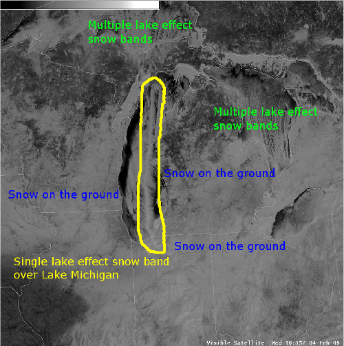
A band of heavy lake effect snow formed on Tuesday night over Lake Michigan, affecting parts of northwest Indiana and extreme southwest lower Michigan. The visible satellite image below shows how the single band extended along the length of Lake Michigan in contrast to the multiple bands over Lake Superior and Lake Huron.
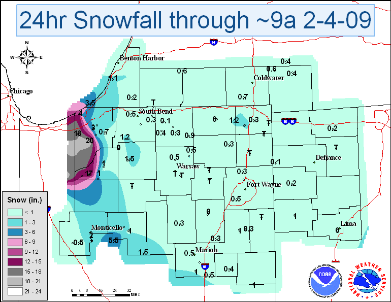
The heaviest snow fell in Indiana in Porter and La Porte counties, where several locations reported more than 16 inches of snow through around 9a on Wednesday. Snowfall rates of 1-3" per hour and whiteout conditions were also reported on Tuesday night. The map below includes official and unofficial reports from emergency managers, co-op program observers, CoCoRaHS, snow spotters, and amateur radio operators through around 9a on Wednesday. Much appreciation is extended to everyone who measured snowfall and made those reports available.
Kanofsky
Hazards
Heat Related
Winter Related
Watch/Warning
Outlook
Storm Reports
Storm Prediction Center
Submit a Report
Event Ready
Climate
FWA Daily
SBN Daily
FWA Monthly
SBN Monthly
CoCoRaHS
Spring Frost Climatology
Fall Frost Climatology
Severe Climatology
Local Information
Skywarn
COOP
Our Office
WSR-88D
Headline Criteria
NOAA Weather Radio
Weather History
Probabilistic Snowfall
Public Information Statement
Social Media Feeds
Weather Events Page
US Dept of Commerce
National Oceanic and Atmospheric Administration
National Weather Service
Northern Indiana
7506 E 850 N
Syracuse, IN 46567
574-834-1104
Comments? Questions? Please Contact Us.

