Cyclogenesis off the New England coast anchored by strong blocking ridge over Greenland allowed for the first shot of true arctic air southward across the Great Lakes behind an Alberta Clipper December 4th and set the stage for the first significant Lake Effect Snow event across northwest Indiana and southwest Michigan. Lake Effect Snow bands developed in earnest Saturday evening December 4th and continued into Tuesday night on the 7th.
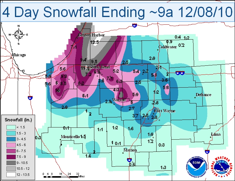
Below is a table highlighting the highest snowfall amounts.
| LOCATION | SNOW AMT | LOCATION | SNOW AMT | |
| Wanatah 4.4 ESE | 10.0 | Hudson 4.6 N | 5.8 | |
| Leesburg 6.7 ESE | 9.7 | La Porte 6.2 N | 5.6 | |
| Granger 2.9 W | 9.7 | Valparaiso 3.9 ENE | 5.6 | |
| Granger 1.6 N | 9.5 | LaGrange 1.3 ENE | 5.4 | |
| La Porte 1.2 E | 9.3 | Mishawaka 2.5 SE | 5.4 | |
| La Porte 1.6 SW | 9.1 | Middlebury 2.6 WSW | 5.2 | |
| Goshen 1.2 WNW | 8.8 | Wakarusa 2.4 NNE | 5.1 | |
| Kingsbury 0.3 WNW | 8.5 | Plymouth 1.1 SSE | 5.1 | |
| Goshen 3.0 WSW | 8.4 | Westville 4.7 ESE | 5.0 | |
| Walkerton 5.7 ENE | 8.2 | Columbia City 5.4 N | 5.0 | |
| La Porte 2.3 ESE | 7.5 | Kingsbury 5.0 ENE | 4.9 | |
| South Bend 4.6 SE | 7.2 | Valparaiso 4.6 NNE | 4.9 | |
| Goshen 1.9 NW | 7.1 | Valparaiso 0.9 NNW | 4.9 | |
| Elkhart 3.1 SSE | 6.9 | Plymouth 2.5 WSW | 4.8 | |
| Mishawaka 3.9 ENE | 6.9 | Valparaiso 1.8 N | 4.5 | |
| Elkhart 4.8 SW | 6.8 | Mishawaka 5.9 SE | 4.5 | |
| Millersburg 0.5 SW | 6.3 | Fort Wayne 9.0 WSW | 4.4 | |
| Albion 3.7 S | 5.9 | Syracuse 0.9 SW | 4.3 | |
| Chesterton 4.2 E | 5.9 | Valparaiso 1.3 NNE | 4.3 | |
| Butler 0.5 NNE | 5.8 | Valparaiso 0.4 SSW | 4.2 |
TH

