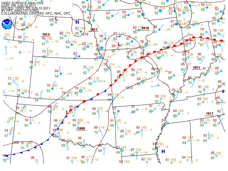
Showers and thunderstorms developed rapidly during the overnight hours late Thursday night into early Friday morning producing very heavy rainfall in excess of 3 inches across portions of the area as a low level warm front lifted northward across the area. The surface warm front began to lift northward during the day Friday. The following is a surface analysis from approximately 330 PM EDT Friday afternoon indicating the approximate position of the surface warm front:
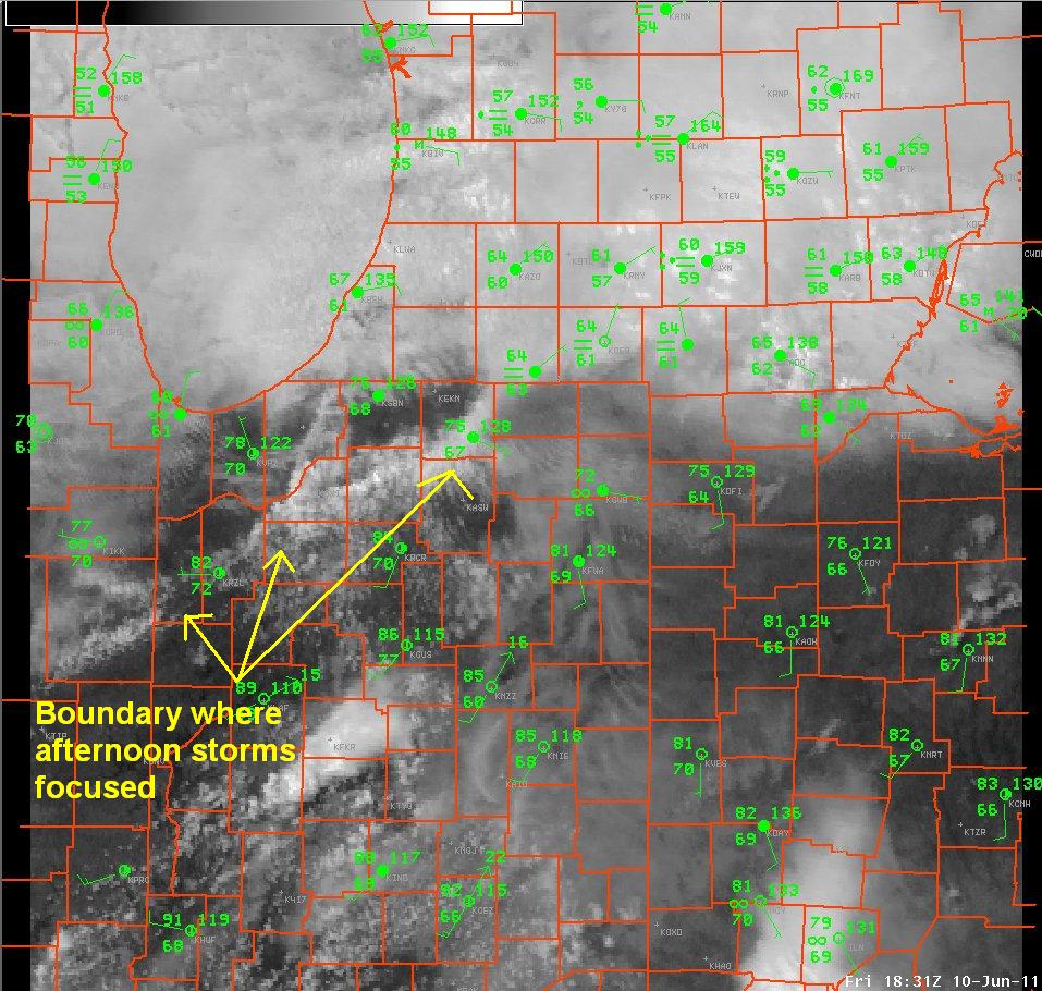
An outflow boundary from dissipating storms in north central and northeast Illinois combined with this frontal boundary to focus afternoon thunderstorm development. The following is visible satellite imagery from approximately 230pm EDT highlighting this boundary. Note the lack of clouds north of this boundary indicating more stable conditions:
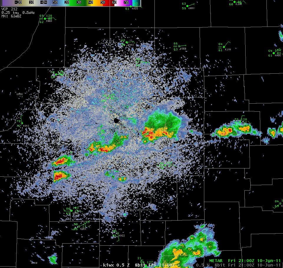
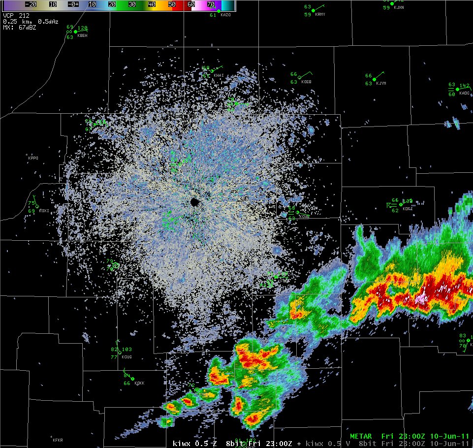
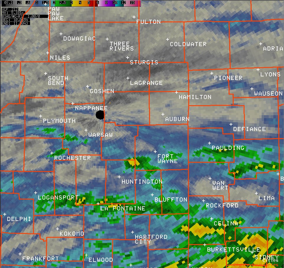
Storm intensified as moderately unstable conditions developed with the afternoon heating. The following are radar images of reflectivity from 500 pm EDT and 700 pm EDT indicating the expanding coverage of the storms as this boundary dropped southeastward. Isolated large hail and wind damage accompanied the strongest storms.
In addition to hail and high winds, very high moisture content also led to very heavy rainfall and flooding in a few instances. The map below shows radar estimated storm total precipitation from late Thursday night through Friday evening encompassing the two rounds of showers and thunderstorms. Note the two bands of higher rainfall, with the yellow colors indicative of radar estimated totals in excess of 3 inches.
The following is a summary of storm reports from Friday afternoon and evening:
PRELIMINARY LOCAL STORM REPORT...SUMMARY
NATIONAL WEATHER SERVICE NORTHERN INDIANA
1048 PM EDT FRI JUN 10 2011
..TIME... ...EVENT... ...CITY LOCATION... ...LAT.LON...
..DATE... ....MAG.... ..COUNTY LOCATION..ST.. ...SOURCE....
..REMARKS..
0235 PM HAIL SOMERSET 42.05N 84.38W
06/10/2011 E0.75 INCH HILLSDALE MI EMERGENCY MNGR
0410 PM HAIL OLD TIP TOWN 41.22N 86.12W
06/10/2011 M1.00 INCH MARSHALL IN PUBLIC
0426 PM HAIL MENTONE 41.17N 86.03W
06/10/2011 M0.88 INCH KOSCIUSKO IN EMERGENCY MNGR
0532 PM HAIL FORT WAYNE 41.08N 85.13W
06/10/2011 M0.25 INCH ALLEN IN PUBLIC
REPORTED AT THE INTERSECTION OF DUPONT AND BETHEL RD.
0535 PM HAIL FORT WAYNE 41.08N 85.13W
06/10/2011 M0.25 INCH ALLEN IN PUBLIC
REPORTED AT DUPONT AND COLDWATER RD.
0537 PM HAIL FORT WAYNE 41.08N 85.13W
06/10/2011 M0.25 INCH ALLEN IN AMATEUR RADIO
OCCURRED ABOUT A QUARTER MILE SOUTH OF DUPONT AND LIMA
RD.
0551 PM HAIL NEW HAVEN 41.07N 85.01W
06/10/2011 M0.50 INCH ALLEN IN TRAINED SPOTTER
0551 PM HAIL MELROSE 41.09N 84.42W
06/10/2011 M0.25 INCH PAULDING OH EMERGENCY MNGR
0554 PM HAIL ROANOKE 40.96N 85.37W
06/10/2011 M0.50 INCH HUNTINGTON IN TRAINED SPOTTER
SLIGHTLY LARGER THAN HALF INCH HAIL REPORTED NEAR HWY
114 AND COUNTY RD 200 E.
0600 PM HAIL FORT WAYNE 41.08N 85.13W
06/10/2011 M0.25 INCH ALLEN IN AMATEUR RADIO
REOPRTED NEAR INTERSECTION OF STILLHORN AND MAPLECREST.
0617 PM HAIL MARION 40.56N 85.66W
06/10/2011 M0.70 INCH GRANT IN PUBLIC
REPORTED ON THE SOUTHEAST SIDE OF TOWN.
0639 PM FLASH FLOOD 1 NNW ROANOKE 40.97N 85.38W
06/10/2011 HUNTINGTON IN AMATEUR RADIO
WATER ONE FOOT DEEP AT INTERSECTION OF SMITH AND CLARK
ST.
0646 PM TSTM WND DMG FORT JENNINGS 40.91N 84.30W
06/10/2011 PUTNAM OH LAW ENFORCEMENT
TREES DAMAGE REPORTED NEAR FORT JENNINGS.
0705 PM TSTM WND DMG POINT ISABEL 40.42N 85.82W
06/10/2011 GRANT IN EMERGENCY MNGR
TREES AND POWER LINES DOWN NEAR 325 W AND SR 26.
0827 PM FLASH FLOOD ROANOKE 40.96N 85.37W
06/10/2011 HUNTINGTON IN LAW ENFORCEMENT
WATER OVER COUNTY ROAD 900N NEAR ROANOKE.

